Showing 1117 items
matching stamp show
-
 Glenelg Shire Council Cultural Collection
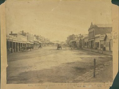
Photograph - Photograph - Casterton, Victoria, n.d
Sourced from Casterton Town Hall (Former Shire of Glenelg)Black and white photo. View of Casterton from elevated position. Shows street running through centre of townBack: Black stamp - 001434 -
 Halls Gap & Grampians Historical Society
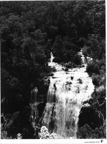
Photograph - B/W, C 1960s
A Forestry Commission photo of MacKenzie Falls.Photo shows a large waterfall (MacKenzie Falls), taken from a fairly high vantage point. The river comes into the falls in two separate streams and there is a large volume of water flowing. The falls are surrounded by thick bush."Publicity & Public Relations branch. When reproducing please Acknowledge FORESTS COMMISSION, VICTORIA. Negative No. 322-2" stamped on rear (except negative number, which is hand written in pen)scenery, mackenzie falls -
 Halls Gap & Grampians Historical Society
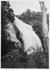
Photograph - B/W, C 1940s (?)
This photo is part of promotional material for tourism, and was produced by Victorian Railways.The photo shows four people scrambling down rocks at the side of a large waterfall (MacKenzie Falls).'Copyright Photograph. This photograph may be reproduced on condition that it is acknowledged as "Victorian Railways Photograph".' stamped on back. "P. 3504" written on back in pencil. "MacKenzie Falls" written on back in blue ink.scenery, mackenzie falls -
 Halls Gap & Grampians Historical Society
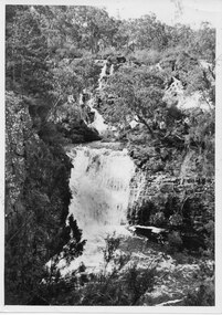
Photograph - B/W
This is a photo of Broken and Drummond Falls. It is part of promotional material for tourism, and was produced by Victorian Railways.The photo shows a series of cascades leading down to a wider set of falls, all surrounded by bush.'Copyright Photograph. This photograph may be reproduced on condition that it is acknowledged as "Victorian Railways Photograph".' stamped on back. "P. 3500" written on back in pencil. "Broken & Drummond Falls" written on back in blue ink.scenery, waterfalls -
 Halls Gap & Grampians Historical Society
Photograph - B/W, C 1960s
This photo was taken in the Mt William area and was material for a Ministry of Tourism campaign.The photo shows a man seated on a rock and looking out over a valley (Mt William area, south west)'This Photograph is with, The Compliments of The . . . ,Ministry of Tourism, Government of Victoria, Please acknowledge, Photo: Michael Chesire' stamped on back. 'Grampians Mt. William' written on back in red pen.scenery, mount william -
 Halls Gap & Grampians Historical Society
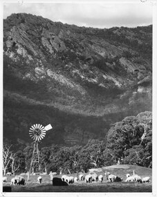
Photograph - B/W, C 1960s
This photo was taken at the foot of the range at Glen Isla. It was material for a Ministry of Tourism campaign.The photo shows sheep grazing in a cleared area with a rocky range rising behind. There is a wind mill in the left foreground and a fence behind the front group of sheep.'This Photograph is with, The Compliments of The . . . ,Ministry of Tourism, Government of Victoria, Please acknowledge, Photo: Michael Chesire' stamped on back. 'Glen Isla, Grampians' written on back in black pen.scenery, grampians ranges -
 Halls Gap & Grampians Historical Society
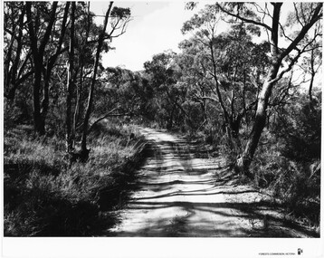
Photograph - B/W, C 1960s
Location unknown.The photo shows a sandy track through bushland.'Forests Commission, Victoria' inscribed on bottom, right of border. 'Publicity & Public relations Branch, When reproducing please Acknowledge Forests Commission, Victoria, Negative No. 322-14' stamped on back.access routes, roads, scenery, grampians ranges -
 Halls Gap & Grampians Historical Society
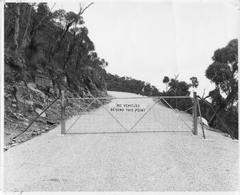
Photograph - B/W, C 1960s (?)
A photo of the gate barring vehicle access to the top portion of the Mt William Road. The photo is part of a Ministry of Tourism campaign.The photo shows an iron gate across a road (Mt William Road). There is a man standing on the edge of the road in the background. A sign on the gate reads 'No vehicles beyond this point'.'Ministry of Tourism of Victoria, 276 Collins St., Melbourne, Nag. No.... , Date ..., Locality Grampians, Subject Gate-Mount William Road.' stamped on back.access routes, roads, scenery, mount william -
 Halls Gap & Grampians Historical Society
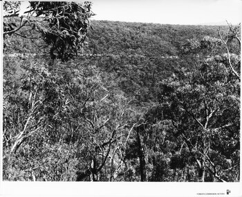
Photograph - B/W, C 1960s (?)
The location in the photo is unknown.The photo shows a road, seen on a slope, in the distance, crossing through bushland'Forests Commission, Victoria' inscribed on bottom, right of border. 'Publicity & Public relations Branch, When reproducing please Acknowledge Forests Commission, Victoria, Negative No. 322-1' stamped on back.access routes, roads, scenery, grampians ranges -
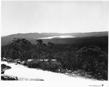
 Halls Gap & Grampians Historical Society
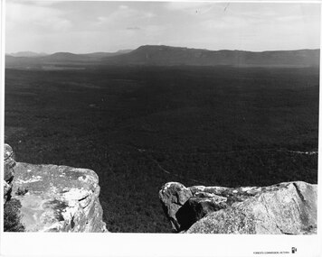
Photograph - B/W, C 1960s (?)
The photo is taken from Reed's Lookout.The photo shows the view across a valley from a (Reed's Lookout). The foreground is two large rock platforms. A reservoir (Moora Moora) and ranges can be seen in the background. Roads can be seen in the valley in the foreground.'Forests Commission, Victoria' inscribed on bottom, right of border. 'Publicity & Public relations Branch, When reproducing please Acknowledge Forests Commission, Victoria, Negative No. 322-23' stamped on back.scenery, lookouts -
 Halls Gap & Grampians Historical Society
Photograph - B/W, C 1960s (?)
This photo is a view from the road at Reed's Lookout.The photo shows the view from beside a road (the road at Reed's Lookout), across bushland to a large reservoir (Lake Wartook). There is a range of peaks in the background. The road forms the foreground.'Forests Commission, Victoria' inscribed on bottom, right of border. 'Publicity & Public relations Branch, When reproducing please Acknowledge Forests Commission, Victoria, Negative No. 322-34' stamped on back.scenery, lookouts -
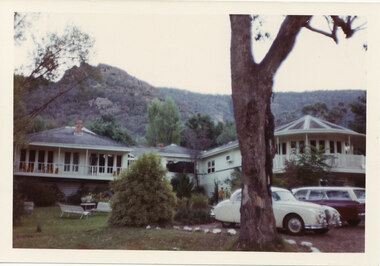 Halls Gap & Grampians Historical Society
Photograph - Coloured, C early 1970s
The photo is of Mountain Grand guesthouse.Photo shows a large building with verandahs in front of the on the left and right wings. Verandah on the right is semi-circular to accommodate the design of the room behind it. A large eucalyptus tree stands in the foreground. Two cars are parked beside the tree."Kodacolor print, Kodak, April-71M" stamped on back in pink.accommodation, mountain grand -
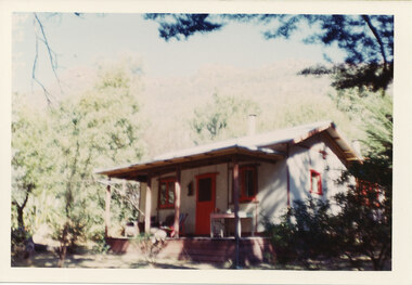 Halls Gap & Grampians Historical Society
Photograph - Coloured, C early 1970s
The cottage was called "Hexham" and was a tourist 'rental' property. It was situated on Mackey's Peak Rd, Halls Gap. It was eventually demolished to make way for a private home.The photo shows a cottage with a verandah, surronded by trees which partly shade the right side. The window frames and door are painted red. A table and chair stand to the right side of the door and a deck chair and an arm chair are on the left side. "Kodacolor print, Kodak, April-71M" stamped on back in pink.buildings, houses -
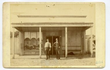 Ararat & District Historical Society (operating the Langi Morgala Museum)
Photograph, c. late19thC
This was the first police station built in Watgania, and it was probably built during the goldrush era of late19C to early 20C.The photo is of local significance to Watgania and the Ararat district because of its rarity and because of its subject. There is now (in the year 2023) little or nothing left of the township of Watgania, north of Willaura, though there are still several inhabited properties in this area, which shelters close under the eastern face of the Grampians mountains. The figures in the photo add to its significance, since a good deal of information about the goldfields can be gleaned from their manner and their dress.Black and white photograph mounted on cardboard. Photo shows two men standing outside a building. The man on the right is dressed in a suit and is wearing a hat. The other man is dressed in suits pants and a vest. The window to the right of the front door of the building is boarded up.Inscription: on front: "4216 / MH". Stamped on back: "F.W HARGREAVES". Inscription: on back: 592P (this is its Osborne nbr, and corresponds to a photo-negative taken of the original photo).goldfields, police, watgania, ararat, gold rush, mount william, grampians, police station -
 Ararat & District Historical Society (operating the Langi Morgala Museum)
Currency - coin, Untitled, 1603
This coin was the first shilling minted during the reign of King James I of England (James VI of Scotland), being produced from 1603 to1604. Born on the 19 June 1566, James became King James VI of Scotland at a little over twelve months of age, on the abdication of his mother Mary Queen of Scots. He succeeded to the English Throne as James I on the death of the childless Queen Elizabeth I on 24 March 1603. He was crowned on 25 July 1603, ruling over a united England, Scotland and Wales for 22 years until his death in 1625 at the age of 58.Small, hammered silver coin with a portrait of a male head facing to the right and a value of XII (12) stamped to the left of the portrait. There is an inscription stamped around the perimeter of the coin, which also shows a Thistle mintmark. The reverse side of the coin shows a shield (centred) divided into four sections. A hole has been pierced through the top of the coin between the Thistle mintmark and the King's Crown. "EXVRGAT DEVS DISSIPENTVR INIMICI" "IACOBVS DG ANG SCO FRA ET HIB REX" coin, shilling, king james 1, 1600s, british monarchy, ararat, langi morgala museum -
 Ararat & District Historical Society (operating the Langi Morgala Museum)
Barkly Street, Ararat, perhaps 1870s
This is one of a dozen or so pictures of very early Ararat held by Langi Morgala Museum, and can be compared to a succession of later photographs to illustrate the growth of the town of Ararat. The date suggested by the inscription on the front is probably a reference to some other occurrence, since the street seems far to built-up for 1856-1860. The date is more likely the 1870s, or even the 1880sThis photograph, though not in good condition, is one of the few in the possession of Langi Morgala Museum that shows very early Ararat. It is of regional significance, which would be enhanced if a firmer date could be established. This cardboard-mounted large photograph is not in very good condition, but some parts of the image are still clear. There are permanent inscriptions on both front and back, not done in sympathy with the age and importance of the item.On front: "Note hitching posts and the old Turf Hotel, Barkly Street cont[illegible] / 1856-60". On back: museum stamp and photo numbers.barkly-street, ararat, horse, horse-driven, early-ararat, business, commercial -
 Kiewa Valley Historical Society
Black and White photograph of Road Making Machinery, Kiewa Road Making, 25/08/1938
Construction of the main road from South Tawonga to the Bogong High Plains, to provide access to the construction sites for the new Kiewa Hydro Electric Scheme, was commenced early in 1938, the work being undertaken on behalf of the Commission by the Country Roads Board. For the construction work, the Commission purchased three Caterpillar - model R07 - diesel crawler tractors equipped with Kay Brunerei (Brunner) hydraulically operated trailbuilders (angle dozers). This acquisition resulted from a visit to the United States of America in May, 1937 by the Construction Engineer ( Mr. C.H. Kernot) and Assistant Civil Engineer (Mr. J.F. Douglas) where they saw this relatively new type of equipment in use. With the co-operation of the CRB, the Commission demonstrated the operation of these machines at Fishermen's Bend on 6th April, 1938. They were then sent to Kiewa where they commenced operation towards the end of the month. From South Tawonga, the route led immediately across the Western Branch of the Kiewa River necessitating the construction of a bridge 100 feet long. By the end of 1939, the excavation had been 'opened up' for a distance of 19 1/2 miles (approx. 31 km) and of this length, 10 miles (approx. 16 km) had been surfaced.The purchase and use of this type of mechanical equipment in road making was a huge investment, as prior to this most of the work would have been done manually with the use of picks and shovels. Not only were many months of hard manual labour saved, but a very significant amount of time in providing access to the proposed work sites for the new Kiewa Hydro Scheme. This photo is an excellent reminder of how primitive the early machinery was compared to the present but also represents the forward thinking of the State Electricity Commissions engineers in purchasing such innovative equipment . A black and white photograph showing the type of machinery used for road making in the 1930's. It shows a grader being towed by a caterpillar tractor.On the top left hand corner of the photograph , hand written in black ink is the words 'Kiewa Road Making 25/8/1938'. On the right hand side of the photo has been stamped in blue the Number 1. It has been developed on Velox paper (marked on back of photo) with a gloss finish.road making, state electricity commission, caterpillar tractor, kiewa -
 Kiewa Valley Historical Society
Black and white photograph of Surveyor's Camp, 1938, Kiewa River and surveyor's Camp 25/8/38, 25/08/1938
Surveying under the prevailing conditions at this time was an arduous and demanding task. There were no roads beyond Tawonga and access was by bridle tracks, on foot or horseback. This camp was to provide accommodation to those men who were surveying the road from South Tawonga to the Bogong High Plains which was commenced in April, 1938. The actual work was undertaken by the Country Roads Board, on behalf of the State Electricity Commission, using three Caterpillar diesel crawler tractors equipped with Kay Bruneriei (Brunner) lhydraulically operated trailbuilders (angle dozers)This photograph shows the primitive living conditions that were endured by those carrying out the initial field investigations and surveys for the Kiewa Hydro Electric Scheme. It is possibly one of the few photographs in existence of this camp and of the very rustic timber foot bridge across the West Kiewa river. It has been taken from approx. 100m up Simmonds Creek Road. A black and white photograph showing a small, timber foot bridge across the West Kiewa River. There is a man standing on the bridge and two small huts on the far side of the river, against a backdrop of Mt. Beauty and Mt. Bogong.At the top of the photograph, handwritten in black ink is the inscription "Kiewa River and Surveyor's Camp 25/8/38". The number 4 is stamped towards the right upper corner. On the back, in a circle, about 1.3cm in diameter, are the words "Kodak Print". The word "Velox" is faintly discernible on the back as well.surveyor, tawonga, west kiewa river, bridge, camp, secv -
 Kiewa Valley Historical Society
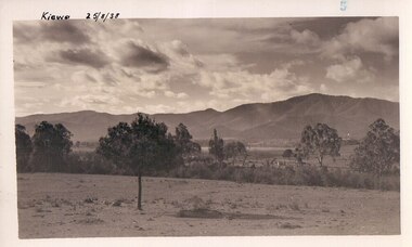
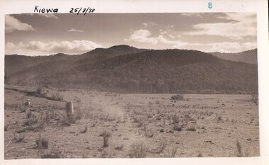
Black and white photograph of farmland, Kiewa, 25/8/38, circa 1938
This photograph was taken in August, 1938 some eight years prior to the establishment of Mt. Beauty as a township. The area was still being used for grazing, and the land was eventually acquired from the local land owners by the State Electricity Commission. The construction of the road, from Tawonga to the High Plains, was commenced in April of this year. This allowed men and heavy equipment to be transported to the work sites for the construction of the Kiewa Hydro Electric Scheme This photograph is important as it shows the upper Kiewa Valley as it was before the establishment of the town of Mt. Beauty. The land has been cleared of natural growth and has been used for grazing cattle. By 1946 housing construction had commenced for the new town of Mt. Beauty and by 1948 street construction in the southern part of the town was completed as far as Hill Street.A black and white photograph of farmland with Mt. Emu in the background. This has been taken from where Mt. Beauty township now stands prior to road making and the erection of houses. A line of trees below the hill line indicates the position of the East Kiewa River. (No. 5 in a set of 8) Handwritten in black ink on the upper left corner of the photograph is the inscription 'Kiewa 25/8/38' and the number 5 has been stamped on the upper right hand corner. On the back is the word 'Velox' which is the name of the photographic paper on which the photo was developed.road construction, kiewa, tawonga, mt. beauty, secv -
 Kiewa Valley Historical Society
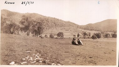
Black and white photograph of farmland, Kiewa, 25/8/38, circa 1938
This photograph was taken in August, 1938 at the time of road making in the area and some eight years prior to the establishment of Mt. Beauty township. The area was still being used for grazing, and the land was eventually acquired from the local land owners by the State Electricity Commission. The construction of the road, from Tawonga to the High Plains, was commenced in April of this year. This allowed men and heavy equipment to be transported to the work sites for the construction of the Kiewa Hydro Electric Scheme. An important photograph as it shows the upper Kiewa Valley as it was before the establishment of the town of Mt. Beauty. The land had been cleared of natural growth and has been used for grazing cattle. By 1946 housing construction had commenced for the new town of Mt. Beauty and by 1948 street construction in the southern part of the town was completed as far as Hill Street.A black and white photograph taken in the upper Kiewa Valley showing farmland with a group of three unidentified people sitting on the grass.Handwritten in black ink is the inscription 'Kiewa 25/8/1938'. In the right corner of the photograph has been stamped the number 6. On the back in a circle, some 14mm across, are the words 'Kodak Print'. The word Velox is also printed on the back.kiewa, mt. beauty, construction, grazing, secv -
 Kiewa Valley Historical Society
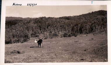
Black and white photograph of farmland, Kiewa, 25/8/38, circa 1938
This photograph was taken in August, 1938, some eight years prior to the establishment of Mt. Beauty a a township. The area was still being used for grazing, and the land was eventually acquired from the local land owners by the State Electricity Commission. The construction of the road, from Tawonga to the High Plains, was commenced in April, 1938 and this photograph was taken August, 1938. This allowed men and heavy equipment to be transported to the work sites for the construction of the Kiewa Hydro Electric Scheme. Prior to this access was by bridle trail, either on horse back or on foot. By 1946 housing construction had commenced for the new town of Mt. Beauty and by 1948 street construction in the southern part of the town was completed as far as Hill Street.This photograph is important as it shows the upper Kiewa Valley as it was before the establishment of the town of Mt. Beauty. The land has been cleared of natural vegetation to allow grazing of cattle. Black and white photograph of grazing farmland with one animal standing in the paddock. The area could possibly be where the golf course now stands with the road to the high plains not yet commenced.Handwritten in the upper left hand corner 'Kiewa 25/8/38'. The number 7 has been stamped in the upper right hand corner. It is part of a set of 8 photographs. On the back are the words Velox repeated several times, indicating the type of photographic papergrazing, kiewa, mt. beauty, secv -
 Kiewa Valley Historical Society
Photograph Farm Land, Kiewa, 25/8/38, circa 1938
This photograph was taken in august, 1938 some eight years prior to the establishment of Mt. Beauty as a township. The area was still being used for grazing cattle and the land was eventually acquired from the local land owners by the State Electricity Commission. The construction of the road, from Tawonga to the High Plains, was commenced in April of 1938. This allowed men and heavy equipment to be transported to the work sites for the construction of the Kiewa Hydro Electric Scheme. Prior to this access was by bridle trail, either on horse back or by foot. By 1946 housing construction had commenced for the new town of Mt. Beauty and by 1948 street construction in the southern part of the town was completed as far as Hill Street.This is an important photograph as it shows the upper Kiewa Valley and the site for Mt. Beauty as it was before the establishment of the town. The land has been cleared of natural vegetation and used for grazing cattle.Black and white photograph of farmland, cattle in the distance, hills in the backgroundHandwritten in the upper left hand corner, in black ink, 'Kiewa 25/8/38'. The number 8 has been stamped in the upper right hand side of the photograph. On the back have been stamped the words Velox, indicating the type of photographic paper.kiewa, mt. beauty, construction, grazing, secv -
 Eltham District Historical Society Inc
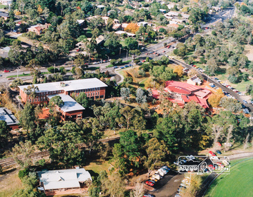
Photo album, Aerial view showing the Shire of Eltham office, new Eltham Library and relocated Shillinglaw Cottage, 1994, 1994
Library Development The library building has been designed to reflect its parkland setting. External features include: the roof which includes interesting aspects when viewed from Main Road; verandahs which provide ramp access and give a sheltered entrance to the building; walls which feature locally-made mudbricks, conventional bricks and copper panels; and space for an outdoor courtyard/reading area which will be developed later. Internally there are a number of features. The building includes a foyer with a fireplace suitable for displays including artwork; a community multi-purpose room suitable for meetings or functions and an outdoor cafeteria. The ceilings are lined with Victorian Ash. The shapes for the ceiling give a free flowing form to the building. Brush Box has been used for the circulation and information desks. The tree trunk columns are Grey lronbark from New South Wales. Arches and and various-shaped windows add interest to the internal structure. The carpet design reflects the Eltham environment and compliments the natural colours and timbers used in the building. Tiles by artist Felix Bosari feature in the building and additional art by local artists will be added externally and internally to the building. The library floor area is approximately 1200 sq metres and houses a collection of 50,000 items. The community multi-purpose room, foyer and community display area totals approximately 300 sq metres. These areas will be available to the community for such events a~ meetings, displays, classes, functions and art exhibitions. The Toy Library and Adult Literacy Group will also be based in the new complex. The value of works/services and fittings/ furniture is $3,040,000 Project Team Project Director: John Stamp, Director - Major Projects Project Manager: Noel Mcinnes, Noel Mcinnes Project Management Pty Ltd Architects: Gregory Burgess and Peter Ryan, Gregory Burgess Pty Ltd Site Foreman - Building Works: John Mantel Site Foreman - Site Works and Foundations: Steven White, Shire of Eltham Surveyor: Gregory Slater, Shire of Eltham Builder: Shire of ElthamShows the relationship of the the Shire of Eltham office which was built on the original location of Shillinglaw Cottage and relocated to Panther Place.The Shillinglaw trees visible, still in their original location, in front of the Shire offices. Photo album of the new Eltham Library presented to the Society by Cr R.J. Manuell, Chairperson Eltham Library Redevelopment Special Committee, 28 Nov 1994 in recognition of the efforts and contribution made by the Shire of Eltham Historical Society to the construction of the Eltham Library complex.Black faux leather album cover, black pages, brass corners and screws, 10 page inserts separated by tissue, 12 photos and information sheets stuck to pages.eltham, eltham library, panther place, shire of eltham, yarra plenty regional library, shillinglaw cottage -
 Kiewa Valley Historical Society
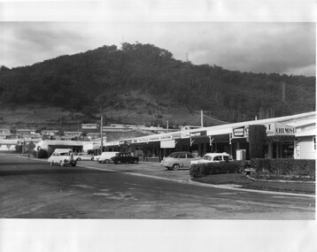
Photo - Kiewa Crescent Mt Beauty Circa 1960s
Mt Beauty was constructed by the SECV in the late 1940s. Built as a construction town for workers and their families during the construction of the Kiewa Hydro Electric Scheme. This photo shows the shops and cars in Kiewa St, Mt Beauty and the houses and Chalet in the background in the early 1960s.Large black and white photo taken from Lakeside Avenue end near the Post Office and looking towards the Chalet and Mt Beauty hill.Stamp in purple: "Please quote / No. LH1399 / when ordering / Laurie Richards / JW 1528"mt beauty township, kiewa st mt beauty, shops and cars in the 1960s mt beauty. -
4th/19th Prince of Wales's Light Horse Regiment Unit History Room
Photograph, AIF, RHQ Troop of 8 Light Horse Regiment, abt 1918
Black & white photo, 195 x 147 mm of RHQ Troop of 8 Light Horse Regiment. Photo shows 36 mounted members formed up on a beachStamp on back: Official photograph AIF in Egypt Copyright Reservedphoto, 8 light horse, ww1 -
4th/19th Prince of Wales's Light Horse Regiment Unit History Room
Photograph, AIF, Horses that left with original 8 Light Horse Regiment, abt 1918
Black and white photo, 195 x 147 mm, notated "Horses that left with original 8 Light Horse Regiment". Photo shows group of horses with mounted soldiers each with about three unsaddled horses. Camp and motor transport lines in backgroundStamp on back: Official Photograph AIF in Egypt Copyright Reservedphoto, 8 light horse, ww1 -
4th/19th Prince of Wales's Light Horse Regiment Unit History Room
Photograph, Wadi Henien, 1918
A black & white photograph. It shows a panorama at Wadi Henien near Richon in Syria, a favourite resting camp of the Light Horse brigadesPhoto No 444. Stamp of the War Museum and description on backphoto, light horse, wadi henien -
 Kiewa Valley Historical Society
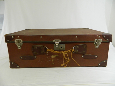
Suitcase
Typical early 1920's to late 1950's suitcases made in Australia using Australian and British manufactured clasps and locks. The majority of manufactured goods especially locks and other metal components were sourced from England. English manufacturers, who in that period, where still world leaders of most manufactured items.This period 1920- 1950 shows the historical shift of the balance between the more complex metal imported items, mainly manufactured in Britain and that of the relevant infant stage of the developing manufacturing industries in the Australian market. The rarity of this type of suitcase is of significancy This suitcase belonged and was used by the C.W.A. of Tawonga.Suitcase brown, possibly lacquered cardboard with leather chrome studded reinforced corners. Lid has two silver coloured(chrome) clasps each end with chrome lock in centre. "D" rings for missing handle secured to main frame by leather straps, these having metal chrome studs. Substitute handle made from string. Metal protective trim on lid and top edge of suitcase compartmentLock stamped "Made in England" and two end clasps stamped "Made in Australia"case, luggage, travel suitcase, country women's association -
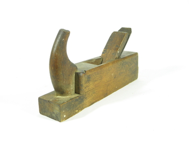 Kiewa Valley Historical Society
Plane Wood, 1890 -1900
J.E. Bleckmann were German Blade makers, registry shows Bleckmann (1899, No. 37190):J.E.Bleckmann, Solingen, registry class 9b). As well as blades for wood working tools they were also sword makers (used in American Civil War), Bayonet makers 1871-1918 and also pocket cutlery (pocket knives) as per advertisement 1907.This wood plane holds historical importance as carpentry tools such as this would have been used in the construction of local homes, outbuildings, furniture. It represents an era before power tools. Investigation is ongoing as to ownership and specific use in the area. Hand made wooden hand plane with metal blade. Carpentry tool from 19th century1/38 / 34 mm stamped into wood on front edge of plane. Metal Blade inscribed "J.E. BLECKMANN/ WARRANTED / CAST STEEL / SOLINGEN/GERMANY"tool, blade makers, hand plane, woodworking. -
 Kiewa Valley Historical Society
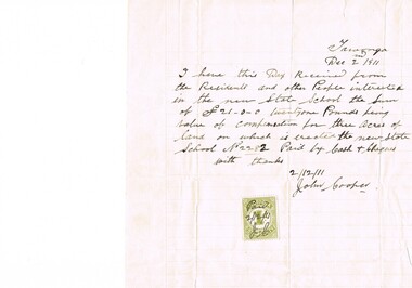
Letter Commerce, Confirmation of Payment, 02/12/1911
This document (dated 1911), is a receipt covering the compensation for the three acres of land required to establish the Tawonga School from its original site (since 1880) to a more central site (since 1911), within the township. This receipt clearly shows the era in which the community involvement and social commitment of landholders was at a higher level, in the early 20th century, than at the latter part. Matters involving community welfare in relatively isolated rural regions was of high priority to every person whether town folk or grazier/farmer or miner. The letter of acceptance of the amount of twenty one pounds for three acres was signed by John Cooper on behalf of Ada Ryder (parent at the school), did not require State Government Compulsory Acquisition process (as it may have, had it been in the latter part of the century and if it were in a city or large town. This social benevolency was part of the period (up to the late 1900's) of the rural Australian environment. This was well before international land investments changed the picture of the socio-economics of country towns.A4 letter of confirmation of payment on pre-lined paper and with a margin. Both margin and lines are coloured in light grey. The page has been folded four times and shows faintly, horizontal lines, of manufacture. The letter is framed with a glass front.This receipt for the compensation of money is hand written in ink and reads: "Tawonga Dec 2 1911, I have this Day Received from the Residents and other People interested in the new State School the Sum of (Pounds sign) 21-0-0 twentyone Pounds being value of compensation for three Acres of land on which is erected the new State School No.2282 Paid by Cash & Cheques with thanks 2/12/11 (Signed) John Cooper" Below this is affixed a Victoria 1 pence stamp duty stamp, on which is written(freehand) Paid 2/12/11 Initialed J Cfinancial letters, receipts, school acquisitons, stamp duty