Showing 11929 items
matching victoria road
-
 Sunshine and District Historical Society Incorporated
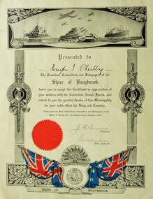
Certificate (Photocopy), Certificate in Appreciation of services with the Australian Armed Forces, Photocopy made 29/09/2015, Original made in 1946
... , NSW on 25 September 1916. He later lived in Hampshire Road...Ballarat Road, Caroline Springs, Victoria, Australia... later lived in Hampshire Road, Sunshine, Victoria, and enlisted ...Corporal Hugh Terence O'Reilly VX108560 was born in Temora, NSW on 25 September 1916. He later lived in Hampshire Road, Sunshine, Victoria, and enlisted at Sunshine with the Australian Army on 29 July 1942. He served in New Guinea, and at the time of discharge on 8 November 1945 was posted with the 22 Australian Infantry Battalion. Additional service number recorded is V37790. In civilian life Hugh Terence O'Reilly was employed in the manufacture of fibrous plaster boards.The significance is that the Shire of Braybrook, and perhaps other councils, recognised their citizens who served in the Australian Armed Forces during World War 2, by presenting them with Certificates in appreciation of their military service.Yellowish background. Grey scale diagrammatic image of warships, tank, and aeroplanes at the top. Vertical posts with swords and wreaths along the sides. At the bottom a diagrammatic image containing in colour the Union Jack and the Australian flag, the Shire of Braybrook Coat of Arms, the Australian Commonwealth Military Forces insignia, and a red coloured circular seal.Presented to Hugh T. O'Reilly. The President, Councillors and Ratepayers of the Shire of Braybrook desire you to accept this Certificate in appreciation of your services with the Australian Armed Forces, and extend to you the grateful thanks of this Municipality for your noble effort for King and Country. Given under the Seal of President, Councillors and Ratepayers of the Shire of Braybrook, this second day of August, 1946. J. R. Parsons - President, 'illegible' - Shire Secretary -
 Melbourne Tram Museum
Document - Research Notes, H. S. McComb, development and timing of the "PMTT" - part 2, 1950's
... Road, Victoria St cable tram terminus, Kew Depot, Candy Corner... Road, Victoria St cable tram terminus, Kew Depot, Candy Corner ...Set of papers, handwritten concerning the development and timing of the "PMTT", Prahran and Malvern - about 40 sheets. Prepared by H. S. McComb - gives layout of the PMTT system, primarily of Burke Road, sketches of track layout, opening dates, sketches of various junctions, bridges, track miles, junctions, reconciliation of track lengths from various sources includes Whitehorse Road, Victoria St cable tram terminus, Kew Depot, Candy Corner, St Kilda terminus, Malvern Depot, High St, Items 2041 to 2052 within box 72.3 in a brown folder marked "PMTT" in red pencil.trams, tramways, pmtt, malvern, routes, track, kew depot, burke rd, surveys, victoria st, whitehorse rd, malvern depot, st kilda, candy corner -
 Federation University Historical Collection
Photograph - Black and White, Durham Lead Roll of Honour, 26/10/1917
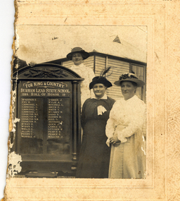
... location of the Honour Board was Garibaldi Hall, Hardies Hill Road... of the Honour Board was Garibaldi Hall, Hardies Hill Road, Garibaldi ...According to the Monument Australia website the 2015 location of the Honour Board was Garibaldi Hall, Hardies Hill Road, Garibaldi, Victoria. Being made in 1917, the honour board never had the end date of the war added. The Ballarat Courier wrote Ballarat Courier, 30th October 1917: At a reunion of old scholars of the Durham Lead State School on Friday 26th October 1917, an honour roll of those who had enlisted in the A.I.F. was unveiled. The honour roll contains a list of 32 names. Half of a black and white photograph showing three women standing to the right of a World War One Honour Board for Durham Lead State School. The women in the centre is thought to be Ellenor Mitchell (nee Austin). The women wear long sleeves and hats. One woman wears a white ribbon. A man's hand and shoulder is evident on the left side of the Honour Board. The building the people stand in front of looks like a weatherboard school, so it is most probably Durham Lead State School Gift of Gordon and Marilyn Vincentdurham lead state school, world war one, honour roll, durham lead state school honour roll, garibaldi hall, ellenor mitchell, ellenor austin -
 Bendigo Historical Society Inc.
Newspaper - NEWSPAPER CLIPPINGS EARLY PHOTOGRAPHS OF BENDIGO STREETSCAPE, Unknown
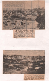
... from the vicinity of Mt. Korong Road, overlooking Victoria.... Korong Road, overlooking Victoria Street and Quick Street. Image ...Two Black & White Early Photographs of Bendigo. (Photograph 1) Panorama is taken from the Masonic Hall location with the Rifle Brigade Hotel on the corner of Rowan and View Streets and Knipe's Folly in top right of image. (Photograph 2) An early photograph of the Bendigo Goldfields the suburb of Ironbark taken from the vicinity of Mt. Korong Road, overlooking Victoria Street and Quick Street. Image shows Knipe's Castle in Boundary Street ''on the Ironbark Ranges'' top right.bendigo, streetscape, rowan & view st, mt korong rd -
 Kew Historical Society Inc
Archive (Sub-series) - Subject File, Bridges (Kew), 1958-present
... Zag Bridge, Penny Toll Bridge, Victoria Street Bridge, Burke... Zag Bridge, Penny Toll Bridge, Victoria Street Bridge, Burke ...Various partiesReference, Research, InformationSecondary Values (KHS Imposed Order)Subject file containing information relating to each of the bridges crossing the Yarra In Kew. The file includes correspondence, photocopied photographs and maps, journal articles, research, and printed ephemera. Bridges referred to and described in the file include Kanes Bridge, Walmer Street Foot Bridge, Johnston Street Bridge, Chandler Bridge, Collins Bridge, Tramway or Zig Zag Bridge, Penny Toll Bridge, Victoria Street Bridge, Burke Road Bridge. The file includes original materials relating to the Victoria Street Bridge Centenary Celebration 1884-1984 -
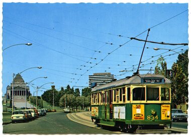 Ballarat Tramway Museum
Postcard, Nu-color-vue or Nucolorvue Productions, MMTB tram No. SW5 834 southbound in St Kilda Road
... 834 southbound in St Kilda Road with the Shine of Remberance..., VICTORIA/ St. Kilda Road with tram and Shine of Remembrance." Also ...Colour postcard with serrated edges of MMTB tram No. SW5 834 southbound in St Kilda Road with the Shine of Remberance in the background. Has as number of parked motor cars on either side of the road. Tram is showing destination of "East Malvern - Darling Road", route 3. Has ads on ends and side of tram, but out of focus. One is for "Dufor Engine Valves" Card by Nucolorvue. On rear of card printed in dark green ink is "MELBOURNE, VICTORIA/ St. Kilda Road with tram and Shine of Remembrance." Also wording for stamp location, copyright etc. On left hand edges is "ML 132", Set EW. Second copy added 21/07/2001. Card is ML 132 NCV1106 - a lot more sharper or in focus card, different colours.trams, tramways, melbourne, st kilda road -
 Kew Historical Society Inc
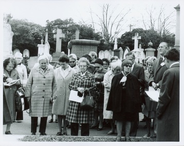
Photograph - Tour of the Boroondara (Kew) General Cemetery, 1977
... an unusual triangular reserve bounded by High Street, Park Hill Road... triangular reserve bounded by High Street, Park Hill Road ...Boroondara Cemetery, established in 1858, is within an unusual triangular reserve bounded by High Street, Park Hill Road and Victoria Park, Kew. By the 1890s, the Boroondara Cemetery was a popular destination for visitors and locals admiring the beauty of the grounds and the splendid monuments. The Boroondara Cemetery is of historical significance for the graves, monuments and epitaphs of a number of individuals whose activities have played a major part in Australia's history. They include the Henty family, artists Louis Buvelot and Charles Nuttall, businessmen John Halfey and publisher David Syme, artist and diarist Georgiana McCrae, actress Nellie Stewart and architect and designer of the Boroondara and Melbourne General Cemeteries, Albert Purchas.Walking tour led by Kew Historical Society members for members of the Royal Historical Society of Victoria in 1977. The photograph shows members of both parties assembled at a grave in the Cemetery. The photograph was one of six taken by KHS member Stewart West on that occasion, and subsequently donated by him to the collection by him.Reverse: "Front row in dark coat and glasses - Mrs Mills, With dark glasses reading - Mrs Ekberg (KHS member); Second from right Mr Slattery then president of Society; Far left Miss B Mackie (KHS member)" boroondara general cemetery, kew cemetery, walking tours -
 Kew Historical Society Inc
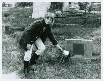
Photograph - Tour of the Boroondara (Kew) General Cemetery, 1977
... an unusual triangular reserve bounded by High Street, Park Hill Road... triangular reserve bounded by High Street, Park Hill Road ...Boroondara Cemetery, established in 1858, is within an unusual triangular reserve bounded by High Street, Park Hill Road and Victoria Park, Kew. By the 1890s, the Boroondara Cemetery was a popular destination for visitors and locals admiring the beauty of the grounds and the splendid monuments. The Boroondara Cemetery is of historical significance for the graves, monuments and epitaphs of a number of individuals whose activities have played a major part in Australia's history. They include the Henty family, artists Louis Buvelot and Charles Nuttall, businessmen John Halfey and publisher David Syme, artist and diarist Georgiana McCrae, actress Nellie Stewart and architect and designer of the Boroondara and Melbourne General Cemeteries, Albert Purchas.Walking tour led by Kew Historical Society members for members of the Royal Historical Society of Victoria in 1977. The photograph shows a Kew youth placing a sprig of Rosemary on Ellen Quick's grave. The photograph was one of six taken by KHS member Stewart West on that occasion, and subsequently donated by him to the collection by him.Reverse: "Kew youth placing a sprig of rosemary on grave of Ellen Quick nee Derrick who was the first burial on 12/3/1859. Her family Derricks were early Kew Landowners." boroondara general cemetery, kew cemetery, walking tours, ellen quick, dannock family, kew pioneers -
 Vision Australia
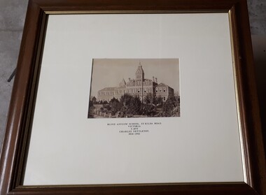
Photograph - Image, Charles Nettleton, Blind Asylum School, St Kilda Road, circa 1875
... Blind Asylum School, St Kilda Road Victoria c. 1875 Charles... Buildings Blind Asylum School, St Kilda Road Victoria c. 1875 ...Unsubstantiated photograph of the Asylum for the Blind in 1875. The four storey bluestone building rises above a group of trees planted in the garden. A picket and wire/string fence border the unpaved circular driveway. 2 black and white images of the Guiding Light at Elanora Blind Asylum School, St Kilda Road Victoria c. 1875 Charles Nettleton 1826-1902 Spencer Scott Sandilands 546 High Street, East Preson, 3181 Melbourne, Victoria, Australia, Tel: (03) 529 8011 Fax: (03) 521 1754 33 George Street, The Rocks, 2000 Sydney, New South Wales, Australia, Tel: (02) 241 4251 Fax: (02) 2414535 Rare Prints, Antiquarian Books, Old Maps, Australiana, Antiques, Photographs, Framing c.1875 Charles Nettleton School from the Blind Original Photograph $65 Guaranteed over 100 years oldroyal victorian institute for the blind, buildings -
 Whitehorse Historical Society Inc.
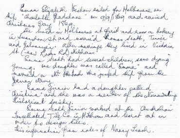
Document, Emma Elizabeth Weston
... in Victoria street (now rooks Road) and had several children, one...Whitehorse Historical Society Inc. 2-10 Deep Creek Road ...Information from the notes of Nancy Leach re Emma Elizabeth Weston who sailed for Melbourne on the 'Charlotte Gladstone' on 9/9/1869.Information from the notes of Nancy Leach re Emma Elizabeth Weston who sailed for Melbourne on the 'Charlotte Gladstone' on 9/9/1869. She subsequently ran a bakery in Swanston street and later married Thomas Scott, Tinner and Galvanizer. They lived in Victoria street (now rooks Road) and had several children, one daughter being named Emma. Emma married Mr. Ottenbach who jumped ship from the German navy and they had a daughter, Christina who was a member of the Nunawading Historical society. Emma (Junior) worked at the Australian tesselated tile Co. in Mitcham and learnt art in order to design tiles.Information from the notes of Nancy Leach re Emma Elizabeth Weston who sailed for Melbourne on the 'Charlotte Gladstone' on 9/9/1869. weston, emma elizabeth;, scott, thomas, emma elizabeth, otterbach mr, otterbach, christina emma, australian tesselated tile co pty ltd, leach, nancy, pioneers -
 Melbourne Tram Museum
Document - Research Notes, H. S. McComb, Domain Road, Park St, Toorak Road and Chapel St lines, c1930
... Melbourne beach lines via City Road and Victoria St respectively... Melbourne and South Melbourne beach lines via City Road and Victoria ...Notes 6 pages, pinned together, giving details, opening dates, terminals, depot entries, sheave pits, curves, for the Domain Road, Park St, Toorak Road and Chapel St lines. Second set of notes 4 pages for the Port Melbourne and South Melbourne beach lines via City Road and Victoria St respectively. Single page sketches for both the Flemington Road via North Melbourne and Spencer St to North Melbourne lines - no dimensions or survey notes. Items 2064 to 2075 within box 72.3 in a brown folder marked "MT&O Co." red pencil on the front cover.trams, tramways, mto co, cable trams, drawings, reports, surveys, toorak rd, chapel st, south melbourne beach, port melbourne, city rd, victoria st, north melbourne, flemington rd -
 Eltham District Historical Society Inc
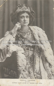
Postcard - Photo Postcard, Postcard: Camille Treherne as the Empress Marie Louise in "Madame Sans-Gêne", c.1913
... as a recluse in a shack in Ingrams Road, Research, Victoria, Australia... as a recluse in a shack in Ingrams Road, Research, Victoria, Australia ...An English actress in her younger days, Camille Treherne was active between 1909 and 1913. She played the role of Empress Marie Louise in "Madame Sans-Gêne" as shown in this postcard image. In her later years, Camille Treherne (Mrs Hill) lived as a recluse in a shack in Ingrams Road, Research, Victoria, Australia. Madame Sans-Gêne is a historical comedy-drama by Victorien Sardou and Émile Moreau, concerning incidents in the life of Catherine Hübscher, an outspoken 18th-century laundress who became the Duchess of Danzig. The play is described by its authors as "three acts with a prologue". "Madame Sans-Gêne (play)." Wikipedia https://en.wikipedia.org/wiki/Madame_Sans-Gêne_(play). Accessed 19 Oct. 2023.On reverse: Mrs Hill a recluse living in Ingrams Rd Research She was an actress (shown here) in younger days then lived in a "shack" in Research.actress, camille treherne, madame sans-gêne (play), postcard -
Ballarat Tramway Museum
Newspaper, The Courier Ballarat, "Tram Man's Miracle escape in collision", 1954
... notes a derailment of a tram at the junction of Main Road... a derailment of a tram at the junction of Main Road and Victoria St ...Newspaper clipping with details of the recovery using tram 21 following an accident between tram 37 and a semitrailer. Newspaper cutting gives details of those trammies involved, Dave Kellett and Herbert Ward. Collided with a semi carrying wool bales. Wal notes the tram was scrapped in 1955. Second cutting notes a derailment of a tram at the junction of Main Road and Victoria St. Noted the delays occurring. Wal has written the date of "Monday 15-6-1953" on the cutting. Contained within Reg Item 5507 - Foolscap binder with green covers, black binding edge and metal clips. See also Reg items 6313 and 5315 for similar items and 6320 for an article on David Kellett. Yields information about the accidents and derailments in Ballarat and collisions with vehicles that resulted in injuries to the driver and major damage to vehicles or passengers.Newspaper clipping from The Courier, 16/4/54 and hand written notes on the collision between with a semi trailer and tram No. 37. accidents, derailments, collision, tram 37 -
 Bendigo Historical Society Inc.
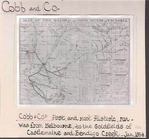
Photograph - COBB & CO,., MAP OF COACH RUN TO BENDIGO
... map of roads to all gold mines in Victoria., showing Cobb & Co... mines in Victoria., showing the Cross roads from one mine ...black and white image ( copy ) on board : image shows map of roads to all gold mines in Victoria., showing Cobb & Co., routes. Written on board: Cobb and Co., Cobb & Co's first and most historic run was from Melbourne to the goldfields of Castlemaine and Bendigo Creek, Jan 1854./// image shows -'Map of the roads to all gold mines in Victoria., showing the Cross roads from one mine to another with indications of various stations divided into squares of ten miles to easily calculate the distance of any new mines when discovered ///There is a list of towns with their distance from Melbourne and to & from distances for other destinations Cobb & Co., routesbusiness, transport, cobb & co., cobb & co., bendigo, transport -
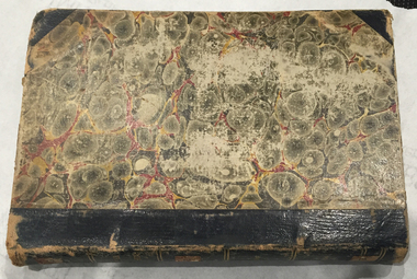 Federation University Historical Collection
Book, Selection of Geological Publications, 09/1866
... Communication - Lieut. Amsinck, 1856 4. Roads for Victoria - William... nuggetty reef maldon victoria internal communication roads ...This book was owned and used by Professor Ferdinand M. Krause of the Ballarat School of Mines.Ferdinand Krause was a renowned teacher at the Ballarat School of Mines. He also produced many important Geological Maps. This book has seven reports that Krause had bound together for his own use. Half black leather bound book with hand marbled paper cover. Marbling on cover is grey, maroon and darker grey with gold bands on black leather spine. The book contains 7 papers on various subjects associated with ores. The book includes: 1. Auriferous, Leads, & Silver Ores at Upper Hungary - G.H.F. Ulrich, 1868 2. Nuggetty Reef, Maldon, Victoria - G.H.F. Ulrich, 1866 3. Internal Communication - Lieut. Amsinck, 1856 4. Roads for Victoria - William Macredie, 1856 5. Mining & Mineral Statistics of Victoria - Robert Brough Smyth, 1866 6. Physical Geography & Geology of Victoria - R.C. Selwyn, 1866 7. Mineralogy of Victoria - G.H.F. Ulrich, 1866 Leather component is black with gold bands on spine with "Silver Ores etc" written on spine. 'G" on square cream paper at top of spine; "2" on square cream paper on middle of spine; and "3" on square cream paper on bottom of spine. Inside front cover on red paper rectangle near spine "bound by W. PAUL 17 Lydiard St BALLARAT" "Ferdinand M Krause C E" handwritten in black ink on title page of first paper (right hand side)treatment, auriferous, lead, silver ores, nuggetty reef, maldon, victoria, internal communication, roads for victoria, mining, mineral statistics, geography, geology, mineralogy, ulrich, amsinck, selwyn, ferdinand krause, macredie -
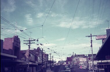 Ballarat Tramway Museum
Slide - 35mm slide/s - set of 4, Dave Simpson, late 1960's early 1970's
... of Stones Corner, corner of Bridge St, Victoria St and Main Road... trams Main Road Bridge St Victoria St Stones Corner tram 26 tram ...Yields information about Stones Corner and the traffic situation in Bridge St.Set of four 35mm slides - Anscochrome white plastic mounts of Stones Corner, corner of Bridge St, Victoria St and Main Road. .1 - shows the overhead arrangements, with a tram about to enter Bridge St from Main Road. Has the Caltex service station in the background, also advert or roof signs for Viscount Ambassador Caravans, K&O (Digger) Schonell Sports Cycles and Electrical store. .2 - No. 26 inbound with many passengers - showing Mt Pleasant - could be running a Special. .3 - ditto with many cars in the photograph. .4 - tram 39 about to enter Bridge St from Main Road - has a red letter box on corner.tramways, trams, main road, bridge st, victoria st, stones corner, tram 26, tram 39 -
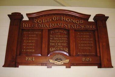 Coal Creek Community Park & Museum
Honour Roll, Kilcunda Road School Honor Roll
... and Buchanans' Roads, Bena, Victoria, 3946. The school was located... and Buchanans' Roads, Bena, Victoria, 3946. The school was located ...This WWI Honor Roll was originally displayed in the Kilcunda Road State School (no.3337), which was located at the north east corner of the intersection of the Bena - Kongwak and Buchanans' Roads, Bena, Victoria, 3946. The school was located amongst the cypress trees at 645 Bena-Kongwak Road. The school was relocated in 2008 to the Coal Creek Community Park and Museum, 12 Silkstone Road, Korumburra, 3950 to become the Masonic Lodge building in the park display. On the west side of the intersection of the Bena - Kongwak and Buchanans' Roads is a brass plaque on a granite boulder with the following inscription TO COMMEMORATE THE DISTRICT OF KILCUNDA ROAD First Surveyed 1879. This is the site of the KILCUNDA ROAD UNITING CHURCH 1911 to 1966. Diagonally opposite at 645 Bena-Kongwak Road was the site of the KILCUNDA ROAD PRIMARY SCHOOL No: 3337, 1902 to 1975. Erected by The School Mother’s Club continuing as The Kilcunda Road Social Club 2008. One of the few remaining historic items from Kilcunda Road settlement.Honour roll of varnished wood, with three panels, an undulating shaped pediment, plain columns at sides, painted gold text and the Australian Imperial Forces insignia on base.Roll of Honor, Kilcunda Road State School. In Honor of Old Scholars of this school who served the Empire in the Great War, 1914-1919, Australian Imperial Force. (X) These made the supreme sacrifice. Sister J.E. Turner , E.N. Barge, E.F. Binding (X), E.H. Bunn, D. James (X), W.James, A. James (X), R. H. James, A.G. Rose (X), C.W. Stanlake, G. Wuchatsch, R. Wuchatsch, T.E. Young kilcunda road, honour roll, state school no.3337., wwi -
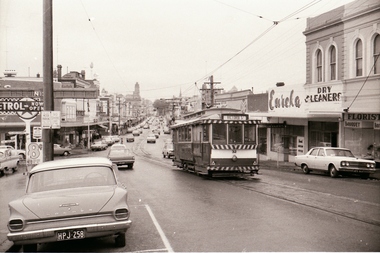 Ballarat Tramway Museum
Negative - Set of 5, Campbell Duncan, 2/07/1971 12:00:00 AM
... of trams at Stones Corner - Bridge St, Victoria St and Main Road... at Stones Corner - Bridge St, Victoria St and Main Road. .1 ...Yields information about tram operations and the street views at Stones Corner.Set of 4 photographs taken on 28/2/1971 by Campbell Duncan of trams at Stones Corner - Bridge St, Victoria St and Main Road. .1 - No. 32 leaving Bridge St, climbing Victoria St, for Victoria St. In the view are Eureka Dry Cleaners, Caltex Service Station, Stones Corner and a busy Bridge St. .2 - No. 27? City bound in Bridge St with Stones Corner buildings, K&O (Digger) Schonell Sports Cycles Electrical store, Kodak, Gear Chemist, State Savings Bank of Victoria. .3 - No. 34 for Mt Pleasant, as above and with H. Whitefield Hair Dresser shop in the view. .4 - ditto with tram at the junction and a passenger alighting. .5 - ditto with tram turning the corner for Mt Pleasant.trams, tramways, bridge st, stones corner, victoria st, tram 32 tram 27? tram 34 -
 Royal Australian and New Zealand College of Obstetricians & Gynaecologists (RANZCOG)
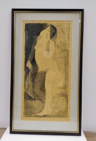
Drawing - Lithographic crayon on paper, John 'Jack' Courier, Standing Figure, c.1970s- early 1980s
... 'FRAMERY/78 Barkers Road/Hawthorn, Victoria, 3122/862 1957.'... of work is printed with text that reads 'FRAMERY/78 Barkers Road ...It is likely this item was received from the estate of John 'Jack' Courier. Courier left a bequest to the College consisting of a significant number of artworks by himself and others.Drawing in lithographic crayon on paper. Drawing depicts a nude female figure with abstract detailing. The drawing is in black crayon on yellow paper. Handwritten inscription at the bottom of the drawing reads 'Standing Figure J. Courier'. The drawing has been mounted on card and framed in a back frame with gold trim on the inner edge. Handwritten text on the back of the object reads '1970s-early 80s/Artist/JOHN COURIER/368 TOORAK RD/STH YARRA 3141/MELB VIC/MEDIUM DRAWING IN LITHOGRAPHIC CRAYON/Price $200'. There is a hanging wire as well as D ring fixtures attached to the back of the work for hanging. Small sticker at the bottom centre of back of work is printed with text that reads 'FRAMERY/78 Barkers Road/Hawthorn, Victoria, 3122/862 1957.' -
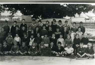 Whitehorse Historical Society Inc.
Photograph, Prep - Mitcham Primary - 1940, 1940
... in background at corner of Mitcham Road and Victoria Street. Back row... and stable in background at corner of Mitcham Road and Victoria ...Black and white photograph of Prep grade (Grade 1A) of Mitcham Primary School in 1940. Davin's Dairy and stable in background at corner of Mitcham Road and Victoria Street. Back row - ????Sargeant, David McLean, ???????, John Robertson, Keith Jones, Herb Lilburn, Dave Jones, Jeff Ellis, Alfred Gadsen. 2nd Row - Dawn freeman, Clare Smith, Barbara Savage, Keitha Petty, Marjory Stonehorn, Judith Honeybun, ??????, Pat Flynn, Peggy Burns, Betty Dashwood, Norma Hennessy. 3rd Row - Thelma Burton, Irene Schafer, Robin Leeworthy, Maureen Webster, Barbara Spelling, Margaret Newing, Judith Gorsuch, Lorna Treverton, Valda Hancock, Marion Cumming, ??? Taylor. Front Row - Bill McCaulay, Graham Clements, John Colman, Vernon Osterlind, Arthur Charles, ???? Boyle, Keith Brown, Alan Smith, Micky Dee, Lawrence Petty.mitcham primary school, no. 2904, sargeant, lilburn, herb, jones, keith, robertson, john, mclean, david, dave, ellis, jeff, gadsen, alfred, freeman, dawn, hennesy, norma, dashwood, betty, burns, peggy, flynn, pat, honeybun, judith, stonehorn, marjory, petty, keitha, savage, barbara, burton, thelma, smith, clare, schafer, irene, taylor, cumming, marion, hancock, valda, treverton, lorna, gorsuch, newing, margaret, spelling, webster, maureen, leeworthy, robin, bill mccaulay, fry, lawrence, dee, micky, alan, brown, boyle, charles, arthur, osterlund, vern, colman, clements, graham -
 Kew Historical Society Inc
Plan, Melbourne & Metropolitan Board of Works : Borough of Kew : Detail Plan No.1302, 1910
... stretched, then and now, from Studley Park Road to Victoria Street..., from Studley Park Road to Victoria Street, Richmond ...The Melbourne and Metropolitan Board of Works (MMBW) plans were produced from the 1890s to the 1950s. They were crucial to the design and development of Melbourne's sewerage and drainage system. The plans, at a scale of 40 feet to 1 inch (1:480), provide a detailed historical record of Melbourne streetscapes and environmental features. Each plan covers one or two street blocks (roughly six streets), showing details of buildings, including garden layouts and ownership boundaries, and features such as laneways, drains, bridges, parks, municipal boundaries and other prominent landmarks as they existed at the time each plan was produced. (Source: State Library of Victoria)This plan forms part of a large group of MMBW plans and maps that was donated to the Society by the Mr Poulter, City Engineer of the City of Kew in 1989. Within this collection, thirty-five hand-coloured plans, backed with linen, are of statewide significance as they include annotations that provide details of construction materials used in buildings in the first decade of the 20th century as well as additional information about land ownership and usage. The copies in the Public Record Office Victoria and the State Library of Victoria are monochrome versions which do not denote building materials so that the maps in this collection are invaluable and unique tools for researchers and heritage consultants. A number of the plans are not held in the collection of the State Library of Victoria so they have the additional attribute of rarity.Original survey plan, issued by the MMBW to a contractor with responsibility for constructing sewers in the area identified on the plan within the Borough of Kew. The plan was at some stage hand-coloured, possibly by the contractor, but more likely by officers working in the Engineering Department of the Borough and later Town, then City of Kew. The hand-coloured sections of buildings on the plan were used to denote masonry or brick constructions (pink), weatherboard constructions (yellow), and public buildings (grey). The absence of buildings and or property in Kew facing the Yarra is the most notable feature of this plan. Walmer Street and its bridge stretched, then and now, from Studley Park Road to Victoria Street, Richmond. On the Richmond side of the Yarra, there was evidence in 1904 of industry (‘Wool shed’; Soap Works’) and entertainment (‘Skittle Alley’). In reality, another Plan (No.1303) shows Chinese Gardens bordering the Yarra on the Kew side and buildings in Young Street.melbourne and metropolitan board of works, detail plans, mmbw 1302, cartography -
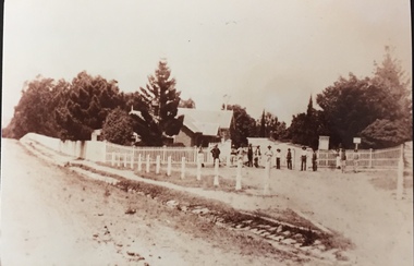 Kew Historical Society Inc
Photograph - Entrance to Boroondara General Cemetery
... an unusual triangular reserve bounded by High Street, Park Hill Road... triangular reserve bounded by High Street, Park Hill Road ...Boroondara Cemetery, established in 1858, is within an unusual triangular reserve bounded by High Street, Park Hill Road and Victoria Park, Kew. The caretaker's lodge and administrative office (1860 designed by Charles Vickers, additions, 1866-1899 by Albert Purchas) form a picturesque two-storey brick structure with a slate roof and clock tower. A rotunda or shelter (1890, Albert Purchas) is located in the centre of the cemetery: this has an octagonal hipped roof with fish scale slates and a decorative brick base with a tessellated floor and timber seating. The cemetery is surrounded by a 2.7 metre high ornamental red brick wall (1895-96, Albert Purchas) with some sections of vertical iron palisades between brick pillars. Albert Purchas was a prominent Melbourne architect who was the Secretary of the Melbourne General Cemetery from 1852 to 1907 and Chairman of the Boroondara Cemetery Board of Trustees from 1867 to 1909. He made a significant contribution to the design of the Boroondara Cemetery. (Source: Heritage Victoria)This photograph is one of the earliest known photographs of the cemetery, showing the early plantings and fences.Later print copy of an undated original photographic positive of the entrance to the Boroondara General (Kew) Cemetery. The Cemetery had been opened in 1855. This view is from Bulleen Road (now High Street) showing a group of 12 or 13 men standing in a line outside the entrance. At this time, the clocktower and high brick fence had not been constructed, but the trees have reached a substantial heightPencil inscription on reverse - "Boroondara Cemetery Entrance 1862"boroondara general (kew) cemetery, cemeteries -- melbourne (vic.) -
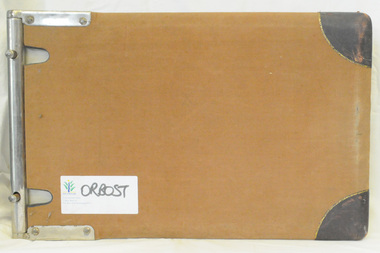
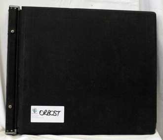 Orbost & District Historical Society
ledger, late 1950's - 1970's
... roads in Victoria between 1913 and 1983. It was succeeded... roads in Victoria between 1913 and 1983. It was succeeded ...This ledger was used by the Shire of Orbost in the late 1950's - 1970's.The item was donated to Orbost & District Historical society from P.R.O.V. as a Place of Deposit (POD) item for safe keeping by a local history group or museum. The shire covered an area of 9,347 square kilometres and existed from 1892 until 1994 when it became part of the East Gippsland Shire Council. Orbost was at first included in the Bairnsdale Shire from 1882 and was later part of the Tambo Shire. Because of travelling distances the Croajingalong Shire was created in 1892 (name changed to Orbost Shire 17.2.1893 with James Cameron as the first Shire President. In 1994 it amalgamated to become part of East Gippsland Shire Council. The Country Roads Board was the government authority for the construction and maintenance of main roads in Victoria between 1913 and 1983. It was succeeded by the Road Construction authority on 1 July 1983 and later merged with the Road Traffic Authority on July 1 1989 to form the Roads Corporation. James Cameron, an Orbost farming pioneer and Member of the Legislative Assembly, fathered the Country Roads Board This item is a hand-written record of Orbost Shire Council accounts. It pre- dates computer records. The Shire of Orbost local council no longer exists having been absorbed by the East Gippsland Shire Council.A black ledger with wooden covers. It contains hand-written records of transactions between Orbost Shire Council and the Country Roads Board.bottom left corner - Orbost in black on a white East Gippsland Shire logoledger accounts shire-of-orbost country-roads-board -
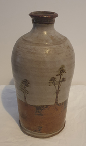 Ballarat Heritage Services
Photograph - Australian Studio Pottery, Ceramic Bottle by Maldon Pottery
... - ) on Barringhup Road, Maldon, Victoria. Tom Metcalf and Graham Masters...- ) on Barringhup Road, Maldon, Victoria. Tom Metcalf and Graham Masters ...Maldon Pottery was established in 1973 by Neville Wilson (1946-1996), Tom Metcalf (1948- ) and Graham Masters (1950- ) on Barringhup Road, Maldon, Victoria. Tom Metcalf and Graham Masters Masters graduated from Bendigo College of Advanced Education all Bendigo graduates. Wilson ) He was a skilled drawer and did all the brushwork. Metcalf (1948- ) graduated in 1968, did two years' work experience at Non-porite in Melbourne, then worked as a thrower and decorator at Bendigo Pottery from 1971-73. He is T.M. on Epsom ware. Masters (1950- ) graduated in 1973 and established the Enterprise Pottery at Myers Flat with Morris Hesse in 1974, so must have joined the partnership later than the others. He left in 1984 to set up his own Sweenies Creek Pottery. Metcalf left in the late 1980s, leaving Wilson to operate the pottery by himself until his death in 1996. As well as using the Maldon Pottery stamp, Wilson signed some of his work with his name or an impressed 'N'. Photograph of a hand thrown ceramic bottle, with glaze design depicting an Australian landscape in the 'continuous trees' pattern.maldon pottery, ceramics, australian studio pottery -
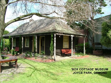 City of Moorabbin Historical Society (Operating the Box Cottage Museum)
Photograph - ' Box Cottage' Reconstruction, c1841
... the original pioneer cottage site, in Joyce Park, Jasper Road, Ormond... Park, Jasper Road, Ormond, Victoria. The museum has copies ...The original small, pioneer cottage was built in the late 1840s to early1850s, by an unknown pioneer. It was located on part of a 30 Acre allotment that was originally part of Henry Dendy’s Special Survey granted in 1841. The doors and window sashes, (made of red deal joinery timber), as well as the brass locks and fittings, are from the original cottage, and were imported from England.The fire-place bricks are from the original cottage, and are sun-dried, (not kiln fired), and are hand-made. Convict marks can be seen on two bricks.There is a small display of external cladding shingles from the original pioneer cottage. These shingles were hand-split, and most likely made from locally collected timber The nails included in this display were used to fasten the shingles on the original cottage, and are also hand-made. The enamel nameplate, “Colonial”, on the wall of the cottage, was the name chosen for the original pioneer cottage when a later owner, Mr August Rietman and wife Frieda leased the property in around 1917. August purchased the property 1935 for 1200 Pounds approximately and resided there until 1953. In 1974 Mr Lewis, a timber specialist, found the dilapidated building on property he had recently purchased in Jasper Rd and suggested it be reconstructed and relocated. Moorabbin Council agreed and the Cottage was rebuilt just about 250 metres from its original site. The cost of the rebuild was met by 'Victoria's 150th Committee, plus a small grant from the City of Moorabbin, and Mr Laurie Lewis donated much of the timber for the reconstruction. Although 'Box Cottage' is a re-construction, it is an unique museum that, being located in the midst of a modern community in Ormond Victoria, can educate and demonstrate many aspects of the early settler’s way of life in Victoria. As such, it is an invaluable resource for students and all kinds of visitors. The original small, pioneer cottage was built in the late 1840s to1850s, by an unknown pioneer. It was located on part of a 30 Acre allotment that was originally part of Dendy’s Special Survey granted in 1841. The re-constructed pioneer cottage, named ‘Box Cottage’, is located only a matter of metres from the original pioneer cottage site, in Joyce Park, Jasper Road, Ormond, Victoria. The museum has copies of interesting Land Titles associated with the surrounding land, including the site of the original pioneer cottage, from Dendy’s time, and into the 1900s. ‘Box Cottage’ is named after the pioneers, William and Elizabeth Box, who resided in the original cottage from approximately 1865, until Elizabeth’s death in 1914.The re-constructed cottage plan has followed faithfully the original dimensions, and plan of the original pioneer cottage, and as many original items from that cottage’s long occupation have been incorporated. Convict marks on sun -dried, fire-place chimney bricks. Enamel nameplate 'Colonial' circa1915brighton, moorabbin, cottages, pioneers, ormond, colonial, mckinnon, dendy henry, box william, box elizabeth, convicts, rietman august, rietman frieda, rietman stefanie -
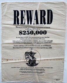 Flagstaff Hill Maritime Museum and Village
Article - Reward Poster - Portuguese Caravel, 1992
... scenic coastal drive- Victoria's Great Ocean Road. Positive... coastal drive- Victoria's Great Ocean Road. Positive sightings ...The mystery of the Portuguese Caravel, commonly known as the ‘Mahogany Ship’ is today regarded as legend and refers to an ancient wreck that is said to lie beneath the sand between Warrnambool and Port Fairy. Its location is currently unknown, but many people have searched for it through the years since the first reported sighting of an unidentified wreck in 1836. For over a century this mystery has fascinated Australians because the existence of such a vessel could throw light on the earliest phase of exploration of Eastern Australia by Europeans. The interest in the mystery was high enough for the Victorian Government to offer a reward in 1992 which was subsequently withdrawn a year later with no monies being paid.This item is historically significant because of its relationship to an ongoing mystery (the Mahogany Ship) that may throw light on the early exploration of Australia. The offering of a reward, 150+years after the first recorded sighting, by the Victorian Government points to the ongoing fascination with this subject to the Victorian people.A reward poster printed on calico. Even though the poster was created in 1992 it follows the regular structure of a reward poster from earlier times; the word REWARD in large print at the top, the amount $250,000 in bold type and an imagined drawing of the missing Portuguese Caravel.Printed text: REWARD Notice is hereby given that the Government of Victoria is offering a REWARD of $250,000 for the DISCOVERY of an international invader that has eluded authorities for more than 400 years. Believed to be a PORTUGUESE CARAVEL, this traveller is thought to be hiding somewhere along the world's most scenic coastal drive- Victoria's Great Ocean Road. Positive sightings could rewrite the HISTORY OF AUSTRALIA. More than 20 unconfirmed sightings have been reported since 1836. Description: Approx. 26 metres long, 12 metres wide, 20 metres in height, dark brown in colour. BOUNTY HUNTERS AND INTERESTED PARTIES SHOULD APPLY TO: FLAGSTAFF HILL MARITIME MUSEUM, PO BOX 574 WARRNAMBOOL 3280 OR TOURISM MANAGER, DEPARTMENT OF CONSERVATION & ENVIRONMENT, 8TH FLOOR 250 VICTORIA PARADE, EAST MELBOURNE 3002 BY ORDER OF THE VICTORIAN MINISTER FOR TOURISM. Printed image: back view of a Caravel in full sail flagstaff hill maritime museum and village, great ocean road, shipwreck coast, warrnambool, port fairy, portuguese caravel, mahogany ship, reward poster, victorian government -
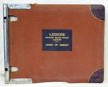 Orbost & District Historical Society
ledger, 1950's -1960's
... for the construction and maintenance of main roads in Victoria between 1913... for the construction and maintenance of main roads in Victoria between 1913 ...This ledger was used bt the Shire of Orbost local government to record Country Roads Board accounts 1950's and 1960's. The item was donated to Orbost & District Historical society from P.R.O.V. as a Place of Deposit (POD) item for safe keeping by a local history group or museum. The shire covered an area of 9,347 square kilometres and existed from 1892 until 1994 when it became part of the East Gippsland Shire Council. Orbost was at first included in the Bairnsdale Shire from 1882 and was later part of the Tambo Shire. Because of travelling distances the Croajingalong Shire was created in 1892 (name changed to Orbost Shire 17.2.1893 with James Cameron as the first Shire President. In 1994 it amalgamated to become part of East Gippsland Shire Council. The Country Roads Board was the government authority for the construction and maintenance of main roads in Victoria between 1913 and 1983. It was succeeded by the Road Construction authority on 1 July 1983 and later merged with the Road Traffic Authority on July 1 1989 to form the Roads Corporation. James Cameron, an Orbost farming pioneer and Member of the Legislative Assembly, fathered the Country Roads Board. This ledger is a hand-written record of accounts for the Orbost Shire local council. It pre-dates computer records. The Orbost Shire Council no longer exists having been absorbed into the East Gippsland Shire Council.A heavy brown coloured ledger with covered wooden covers. it has steel metal binding. Inside are strips of paper marking pages. It contains blue ink hand-written records of monies in/out (?) to Shire of Orbost Council. On the front cover inside a black rectangle in gold print is " LEDGER COUNTRY ROADS BOARD ACCOUNT ORBOST". It is an "Emu Binder".ledger orbost-shire accounts country-roads-board -
 Orbost & District Historical Society
ledger, 1950's ; 1960's
... for the construction and maintenance of main roads in Victoria between 1913... for the construction and maintenance of main roads in Victoria between 1913 ...This ledger was used by the Shire of Orbost to record transactions with the Country Roads board in 1950's and 1960's. The item was donated to Orbost & District Historical society from P.R.O.V. as a Place of Deposit (POD) item for safe keeping by a local history group or museum. The shire covered an area of 9,347 square kilometres and existed from 1892 until 1994 when it became part of the East Gippsland Shire Council. Orbost was at first included in the Bairnsdale Shire from 1882 and was later part of the Tambo Shire. Because of travelling distances the Croajingalong Shire was created in 1892 (name changed to Orbost Shire 17.2.1893 with James Cameron as the first Shire President. In 1994 it amalgamated to become part of East Gippsland Shire Council. The Country Roads Board was the government authority for the construction and maintenance of main roads in Victoria between 1913 and 1983. It was succeeded by the Road Construction authority on 1 July 1983 and later merged with the Road Traffic Authority on July 1 1989 to form the Roads Corporation. James Cameron, an Orbost farming pioneer and Member of the Legislative Assembly, fathered the Country Roads Board. This item is a hand-written record of accounts of the Orbost Shire local Government. It pre-dates computer records,The Shire of Orbost Council no longer exists having been absorbed into th East Gippsland Shire council.A heavy brown coloured ledger with steel bindings. Covers are probably wooden. It contains hand-written records of transactions the Country Roads Board. -
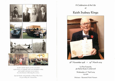 Melbourne Tram Museum
Document - Programme, Le Pine Funerals, "In Memory of Keith Sydney Kings", Apr. 2016
... on the corner of Burke Road and Victoria St Camberwell. .4 - Added 6... held on 10/4/2018 at le Pine on the corner of Burke Road ....1 - Four page - folded A4, heavy card, printed in full colour, Memorial Order of Service for Keith Sydney Kings, featuring a number of photos of Keith. Inside is the Order of Service. NOTE: The date of his birth should have been 12 November 1928. .2 - five A4 sheets, stapled titled "In Memory of Keith Sydney Kings" written by Len Millar for the service. Details Keith's tramway work. .3 - Keith's funeral car was followed by Federal Bus supplied by Driver Bus Lines which Keith and Charles Craig restored. Service held on 10/4/2018 at le Pine on the corner of Burke Road and Victoria St Camberwell. .4 - Added 6/5/2019 - Graeme Rodwell's Eulogy received by email as a word document 4/5/2019. Heading added, font changed to 12 point and page numbers added and saved as a pdf file - see image .5 - AV file - mp4 file of the service - see Reg Item 3458 in AV Files.trams, tramways, funeral, keith kings, buses -
 Warrnambool and District Historical Society Inc.
Booklet - Warrnambool Visitor's Handbooks 1979-2024, Collett, Bain and Gaspar, Printers, 1979-2014
... of Victoria's Shipwreck Coast on Australia's Great Ocean Road [.7... Ocean Road; You'll love every piece of Victoria; Visitors ...This is a collection of eight Warrnambool Visitor handbooks produced between 1979 and 2014 by the City of Warrnambool Tourist Information Centre. They contain maps of Warrnambool, lists of services, accommodation and tourist attractions as well as many advertisements for local businesses.These handbooks give a useful snapshot of businesses and tourist attractions in Warrnambool for each of the years covered. (1979, 1980, 1986, 1990, 1993, 1994, 1995, 2014)[.1a] A 48 page booklet with white pages and blue printing. The front cover has a coloured photograph of Flagstaff Hill with boats on a man made lake in the foreground looking across Lake Pertobe toward South Warrnambool. [.1b] A coloured bifold brochure. The front cover has a fisherman on a cray-boat holding a crayfish in the lower section. The top quarter has a blue back ground with white printing. The rear cover is red and has small photos of the Hopkins River and the Framlingham Forest. [.2] A 48 page booklet with white pages and black printing. The front cover is white with black writing on the left hand side and a colour photograph of the Loch Ard peacock. The Warrnambool Premier Town stylised logo of seven Norfollk pines above blue waves is in the top right hand corner. There is a blank ink Warrnambool Library stamp underneath the logo. The rear cover has photographs of The Twelve Apostles and the Hopkins Falls and the Premier Town Logo [.3] A 40 page booklet with mainly black printing on white paper. There are three fold out maps of Warrnambool and the surrounding district. The glossy cover has a black background with a colour photograph of the Twelve Apostles taken at sunset. The rear cover has three small of Proudfoot's boathouse on the Hopkins River, Flagstaff Hill, and the main beach area. The front cover has black writing inside to peach coloured rectangles. The inside rear cover has a fold out coloured tour map of Western Victoria. [.4] A 40 page booklet printed on glossy white paper with coloured photographs and black and red printing. The front cover has a photograph of The Twelve Apostles surrounded by a white border. There is red writing in the upper border. There is a sandy coloured writing superimposed across the bottom of the photograph and a Victoria's Shipwreck Coast logo in the bottom right hand corner. [.5] A 44 page booklet printed on white paper with black printing. The cream coloured cover has a pale red rectangle with blue writing on the right hand facing edge and includes two stylised Norfolk pines and with waves underneath. There is is an intersecting blue rectangle with cream printing. [.6] A 48 page booklet printed on white paper with black printing. The cover is brown with a cream vertical strip containing black writing on the right hand side. There is a stylised map from Geelong to Mount Gambier showing the Great Ocean Road across the cover. [.7] A 48 page booklet printed on white paper with black print. The glossy colour cover has a photograph of a Southern Right whale fluke. There is white printing on a the blue background of the sky and sea. The bottom left hand side of the front cover has a Tourism Victoria logo made of jigsaw puzzle pieces. The back cover has a stylised coloured map of The Great Ocean Road located in a white rectangle at the top of the page. Within the rectangle is a small map of Australia locating Victoria and the part of Victoria covered by the map. [.8] A 64 page A5 coloured booklet printed on white pages with black print. The white front cover has black and grey print with a colour photograph of two people holding coffee cups watching four race horses being exercised on the beach and in the water of Lady Bay in the early morning. The bottom right hand corner has a Tourism Victoria logo. The rear cover has a mainly blue back ground with a pink orange and green colour splats contains words advertising the 2015 Fun 4 Kids Festival [.1a] Warrnambool The Heart of Victoria's Great Southwest Visitor's Handbook [.1b] Warrnambool City for all seasons; The Heart of Victoria's Great Southwest [.2] Warrnambool visitor's handbook Warrnambool Premier Town 1979-1982 [.3] Warrnambool Handbook Victoria [.4] Warrnambool The Shipwreck Coast [.5] Welcome to Warrnambool Warrnambool Visitors Handbook 1993-1994 [.6] Welcome to Warrnambool Visitors Handbook 1994-95 Rear cover: Warrnambool Centre of Victoria's Shipwreck Coast on Australia's Great Ocean Road [.7] Warrnambool Shipwreck Coast - Great Ocean Road; You'll love every piece of Victoria; Visitors Handbook [.8] Warrnambool Great Ocean Road Official Visitor Guide; It's a wonderful Warrnambool; You'll love every piece of Victoria visitvictoria.com. Rear Cover Live entertainment.Workshops.Creativity.Action 28 June - 5 July 2015 Australia's Best Children's Festival F4K The ultimate winter school holiday adventure Fun 4 kids festival Warrnambool For more information visit Fun4kids.com.au Warrnambool great Ocean Road Victoriawarrnambool, visitor handbooks, tourist information guides, warrnambool maps