Showing 7094 items matching "snowy-river"
-
 Greensborough Historical Society
Newsletter, Greenhills and North Greensborough Progress Association, Community News: official journal of the Greenhills and North Greensborough Progress Association. 27th May, 1971. Edition no. 3/71, 27/05/1971
This edition includes a report on the Progress Association's May 1971 meeting, Councillors' report, Where do all the 5 per cents go?, Pollution of the Plenty River, First catch your frog, Kinder news, Diamond Valley Repertory, Redress for the consumer, Letters to the Editor. A digital copy of the Newsletter is available from Greensborough Historical Society.Newsletter, 15 p., illus. greenhills and north greensborough progress association, greenhills -
 Marysville & District Historical Society
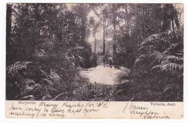
Postcard (item) - Black and white postcard, Nicholas John Caire, Marysville Victoria, Aust, 1858-1918
One of a series of postcards of photographs taken by socialite photographer Nicholas John Caire. N.J. Caire had a great love for the area and in the late 1800's took many photographs of Marysville and its surrounds.One of a series of postcards of photographs taken by socialite photographer Nicholas John Caire. N.J. Caire had a great love for the area in and surrounding Marysville and in the late 1800's took many photographs of Marysville and its surrounds. N.J. Caire was born in 1837 in Guernsey. He arrived in Adelaide about 1860 along with his parents who encouraged his early interest in photography. He opened a studio in Adelaide in 1867 after traveling extensively throughout the Gippsland taking photographs. After marrying in 1870 he moved to Talbot in Victoria until 1876 when he opened a studio in the Royal Arcade in Melbourne. After 1885 N.J. Caire gave up his city work and made his home in South Yarra and devoted the rest of his life to outdoor photography, specializing in the bush, the gullies and the mountains of south-eastern Victoria. Many thanks for P.C./ I am sorry to have kept you/ waiting so long. J. Morris/ Brighton/ Victoria POST CARD [THIS SPACE MAY BE USED FOR COMMUNICATION] ]FOR WRITING ADD (rest has been removed when stamp was removed) Mr Herman Frock/ Petersgaard/ Langebak Street/ Denmark Date Stamp/ MELBOURNE/ FEB 2?/ 4.33/ 1906 Date Stamp/ MASNEDSUND/ KALLEHAVE/ 24.3.06.1.4 Stamp/ BILL HOPKINS COLLECTION/ 21 KENSINGTON PARK ROAD W11/ NOTTING HILL GATE LONDON marysville, victoria, nicholas john caire, bill hopkins collection, postcard, souvenir -
 Kiewa Valley Historical Society
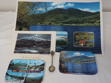
Souvenirs - Mt Beauty
Originally an SEC town built for workers on the Kiewa Hydro Electric Scheme. It became a tourist centre from the 1960s.Examples made to increase tourism with historical photos, historical items no longer used or sought after. Items such as these are a different way of advertising to on-line methods used today1. Coloured shiny poster with photos of mountains, river and fishing backed on to orange & white pattern. 2. Christmas card "Mt Bogong and Mr Beauty Township" on the back in gold Markdon Prints, Porpunkah ..."" 3. Plastic coloured trays x3 - Mt Beauty Vic. x2 and Mt Beauty Victoria (4 photos including Mt Bogong, Falls Creek x2, Kiewa Valley.) 4.Silver plated spoon "Mt Beauty Vic." 1. Printed bottom left hand corner "Mount Beauty, Victoria" 2.Centre front "The Seasons Greetings" with title written under painting also "From the painting by Marcus L. O'Donnell" 3. On the back of the tray with 4 photos - embossed "A Starlite Product ..." 4. Embossed on back of handle "Stuart / Silver plated"mt beauty tourism -
 Federation University Historical Collection
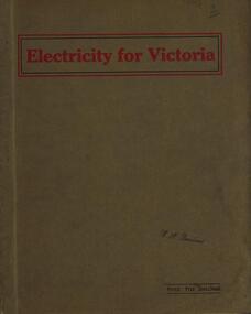
Book, Electricity for Victoria, 1927, 1927
Brown soft covered book. Contents include: Winning Brown Coal at Yallourn Dredge Operation for Overburden Removal Boiler Plant at the Yallourn Power Station Electrical Equipment at the Yallourn Power Station Steam Plant at the Yallourn Power Station Yallourn-Melbourne High Tension Line Yarraville Terminal Station Transmission distribution High Transmission Towers for River Crossing Sugarloaf-Rubicon Hydroelectric Development Briquette factory Subsidiary Activities at Yallourn Future Developments thompson's engineering & pipe co. ltd, briquettes, electricity, power generation, yallourn, yallourn briguetting works, transmission lines, high tension switchgear, insulators, australian porcelain company, substation, brown coal, high tension line, sugarloaf-rubicon, plans, suspension tower, transposition tower, yarraville terminal station, condenser, newport power station, gippsland, hydroelectric -
 Ringwood and District Historical Society
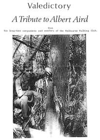
Pamphlet, Funeral Service Valedictory, Albert James Aird (1913-1995), descendant of Ringwood pioneering Aird family
Two and a half page A4 bifold tribute from companions and members of the Melbourne Walking Club with a photograph of Albert on front in a bush setting and loose page insert of order of Service. During Albert's time in the Walking Club he blazed the trail of many cross country walks around Healesville, Mount Donna Buang, Mount Juliet, Mount Buller and the Jamieson River. He was cared for in Donwood Nursing home, Croydon, at the end of his life. -
 Bendigo Historical Society Inc.
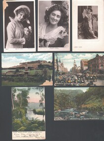
Postcard - WES HARRY COLLECTION: 7 POSTCARDS, 1905 - 09
Group of seven postcards, three of them depict actresses and four are of various scenes around Victoria. (a) Miss Billie Bourke, (b) Carrie Moore, © Miss Carrie Moore as 'Honour in' Tom Jones ', (d) Bourke street on 8 hours day, Melbourne Victoria, (coloured) (e) Fairy Bend, River Yarra, Warburton (colour) (f) Werribee Gorge near Bacchus Marsh Victoria (colour) (g) Lawn Gardens, Flemington, Melbourne (colour).postcard, photograph, various themes, billie bourke, carrie moore, actresses, theatre, melbourne, flemington, werribee gorge, bacchus marsh, fairy bend, river yarra, warburton, bourke street, 8 hours day -
 Whitehorse Historical Society Inc.
Article, The Traditional owners of the Whitehorse region, 1997
Article written for Box Hill Historical SocietyArticle written for Box Hill Historical Society describing the Aboriginal (Koorie) inhabitants of the Whitehorse region. This area was part of the estate of the Wurundjeri-bulluk clan of the Woiwurung Tribe. Kinship and marriage links with the people of the Goulburn River area are described. Daily life as hunter gatherers is described and the pattern of movements within the area. Several locations where traces are still found and where people lived after European settlement are listed. A bibliography is included. 2 pages.Article written for Box Hill Historical Societyaborigines, wurundjeri -
 Bendigo Historical Society Inc.
Document - General Receipts for Government Departs within the City of Bendigo, 1968
Parry CollectionGeneral Receipts for Government Departs within the City of Bendigo 1. State Rivers and Water Supply Commission - Golden Square Office 2. Bendigo Sewerage Authority, 1967-68 Installments 3. City of Bendigo rates 1967-68 for 3 Yandoit St - John S. Parry 4. City of Bendigo 30/5/69 Part Payment of rates receipt 5. City of Bendigo Receipt of $1 for black and white labrador cross.history, bendigo, j s parry collection, city of bendigo council rates -
 Wodonga & District Historical Society Inc
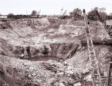
Album - Hume Reservoir Australia Album - View of South Wing Wall Foundations from Top of Tail Tower Pillar, August 1927
This set of photos is from a leather bound album bearing the inscription "HUME RESERVOIR AUSTRALIA" plus 'The Rt. Hon. L. C. M. S. Amery, P. C., M .P.' all inscribed in gold. It was presented to The Rt. Hon. L. C. M. S. Amery, P. C., M. P, Secretary of State for Dominion Affairs on the occasion of his visit to the Hume Reservoir on 2nd November 1927. This album is of local and national significance as it documents the planning and development of the Hume Reservoir up to 1927. It was the largest water reservoir in the British Empire. The album records the pioneering engineering work that went into its construction.DEPARTMENT OF PUBLIC WORKS, N.S.W. RIVER MURRAY WATERS SCHEME. HUME RESERVOIR. 30. View from Top of Tail Tower Pillar - South Wing Wall Foundations. This photograph was taken at right angles to the preceding one, (WHS 00723) ooking downstream along the cut for the South Wing Wall foundation. The granite is at a greater depth here than elsewhere and the cut will be twice as deep before the foundations are cleared. New South Wales. August 1927.hume reservoir australia, river murray waters scheme, hume reservoir construction -
University of Melbourne, Burnley Campus Archives
Newspaper - Newspaper Cutting, The Age, Victorian Horticultural Society, 1862
(1) Photocopy of article in "The Age" 30 January, 1862 p7. (2) Similar article from "the Argus" 30 January, 1962 p4. Description of the annual general meeting of the Victorian Horticultural Society. Description of a competition for a design and that the decorative part of the garden was nearly complete and open to the public. Donors of plants named including Rule (Californian Redwood?) Extension of Swan Street through Richmond Park, past Pic Nic Station to the Gardens and River Yarra.the age, the argus, victorian horticultural society, horticultural society of victoria, monthly meeting, competition for design of experimental gardens, burnley gardens, rule, californian redwood, donations of plants, pic nic station -
 Bacchus Marsh & District Historical Society
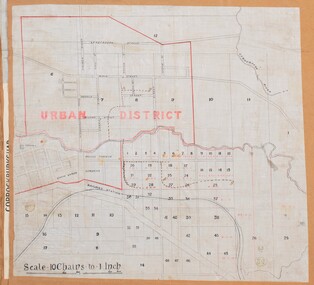
Map, Bacchus Marsh Urban District
The date of this map has not been established but the date would be sometime after 1887 as the Bacchus Marsh Railway Station, which opened in 1887, is shown on the map. A single page paper map showing blocks of land in the urban district of Bacchus Marsh. The 'urban district' is indicated by red drawn lines on the map and includes streets and blocks on the northern side of the Werribee River in Bacchus Marsh, and streets and blocks south of the Werribee in Maddingley. Scale 10 chains to 1 inch. The map is pasted into a bound volume containing 76 maps or plans in total. High resolution digital image stored on BMDHS computer network. bacchus marsh victoria maps, maddingley victoria maps -
 Bendigo Historical Society Inc.
Document - STATE RIVERS AND WATER SUPPLY COMMISSION : GENERAL DESCRIPTION AND PARTICULARS OF EPPALOCK PROJECT, 1/08/1961
State Rivers and Water Supply Commission. Seven-page typed document titled 'General description and particulars of the Eppalock Project.' Subheadings: General, Administration and Works Installation, Field laboratory, Construction programme, Design statistics, Major items of plant in use on the project, Progress to 1st August 1961, Eppalock Reservoir Locality Plan (diagram), Eppalock project works area & arrangement plan (diagram), Eppalock Project cross section of dam along? tunnel (diagram).state infrastructure, water supply, coliban system, state rivers and water supply commission. coliban system. eppalock. -
 Melbourne Tram Museum
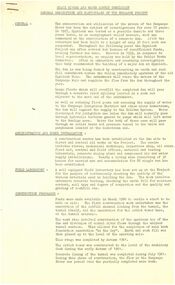
Pamphlet, Committee for the Southbank Light Rail Line, "the vital link", 1993?
Pamphlet - full colour A3 sheet folded to A4, titled "the vital link", outlining a proposal for a tram line connecting Flinders St station to Clarendon St, Port Junction, via the former railway bridge, connecting Batman Ave tram line. Published by the Committee for the Southbank Light Rail Line. Gives reasons and benefits for such a link. Published based on a printing date 1993. Features an image of 2001 on front cover and crossing the Yarra River.trams, tramways, flinders st station, clarendon st, new tramway, batman ave, route 96, light rail, yarra river, tram 2001 -
 Melbourne Tram Museum
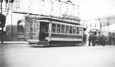
Photograph - Black & White Photograph/s, Lee A Ratten, c1925
Black and white photograph of U class tram No 207 in William St c1925 shortly after opening the line to Williams and Collins St. Line opened 19/7/1925. The tram was built in 1906 for the NMETC as tram No 6 before joining the MMTB fleet in 1922 as U class No 207. The photo shows driver and conductor in front of 2nd unidentified W class tram with several passengers. The tram's destination displayed could be Maribyrnong River.trams, tramways, u class, william st, nmetl, tram 207, mmtb, w class -
 Orbost & District Historical Society
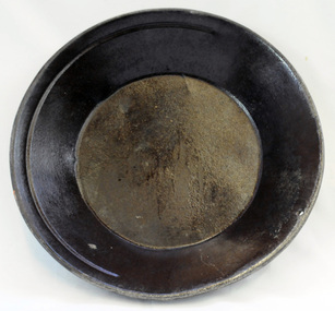
gold panning dish, mid - late 19th century
Panning dishes were used for washing fine gold from river sediments or from the residue trapped in cradles and puddling tubs. They were often used on the edge of streams/rivers to sift gold from alluvial soil or crushed quartz. This simple pan would have been filled with sand and gravel which might have contained gold. The pan was submerged in the water and shaken to sort the gold from the gravel and other material, with the lighter material gradually being washed over the lip until only the heavy deposits, such as gold, remained at the bottom. (ref. Museum Victoria) This pan was used by George Henry Douglas Russell Snr. As a young man prior to his enlistment in WW1 he panned for gold using this dish. During the war he became a vet sergeant in charge of horse lines.Gold panning is the oldest and simplest method of extracting gold. Gold pans had widespread use in alluvial gold fields where water is available. This item is an example of the type of pan commonly used on Victorian gold fields.A circular dull metal panning dish which has a wide rolled top lip which tapers down to a smaller diameter for the base which is flat. The pan has been made from ironmetal which has a coating of another metal with a matte grey finish. It has a small hanging hole and a reinforcing ring all around the top.russell-doug gold-panning mining -
 Orbost & District Historical Society
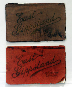
magazines, Atlas Press Pty Ltd, East Gippsland & Railway Extension, 10 September 1908
Orbost and East Gippsland Railway League had proposed a railway extension through East Gippsland in 1908, which aimed to develop an isolated part of the country. At the time, construction of a railway could be considered a beneficial investment for the country as it could increase the population in the region. The proposed railway length in 1908 was about 140 miles and the cost was estimated £800,000. The line was proposed to proceed from Bairnsdale by way of the Lower Nicholson to Bruthen. “After crossing the Tambo River, it would be carried to near Nowa Nowa; the head of Lake Tyers, forward to Orbost. From Orbost it would proceed in a north-easterly way to the New South Wales border. There were different suggested routes between Orbost and the New South Wales border, the first was through Bendoc, another by the Cann River and another which is located between these two. This item is associated with the history of the Orbost-Bairnsdale railway line and therefore reflects the role that the rail line played in the social and economic history of Orbost. The Bairnsdale-Orbost railway was opened in 1916 to serve the agricultural and timber industry. Because of the decline in traffic and heavy operating costs, the line was finally closed in August, 1987. Two small magazines showing the railway extension through East Gippsland. 678.1 has a dark maroon cover with gold print writing. It contains b/w photographs. 678.2 has a red cover with black print writing. Both are bound. 678.1 - inside front cover - M. Beattie ???????? Newmerella 678.2 - inside front cover - Gordon Fisher Orbosteast-gippsland-railway-league railway -
 Orbost & District Historical Society
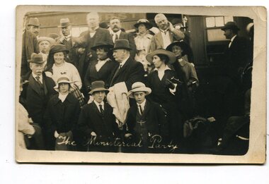
black and white photographs, April 1916
These photographs were taken at the official opening of the Orbost - Bairnsdale Railway Line. In 3150.3 which is of a group of children and two adults those identified in the photograph are ; L - R front row Mary Gilbert; Warren; Betty Gilbert; Marion Gilbert; Mrs Shaw and son; ? Gay; and Pen Gilbert. In 3150.4 L-R front " Mary Gilbert; Bet Gilbert (sitting with glasses); Pen Gilbert(Richardson); Marion Gilbert ( middle front little girl) About 1912 work began at Newmerella on clearing the track for the railway line from Bairnsdale to Orbost. A canvas town sprang up on the higher land adjacent to the river flats. Local farmers supplied meat, milk and fresh produce to the camp, as well as gaining employment carting and labouring. The line opened in 1916, the Orbost railway station being built on the Newmerella side of the river.This item is associated with the history of the Orbost-Bairnsdale railway line and therefore reflects the role that the rail line played in the social and economic history of Orbost. It is a pictorial record of a significant event in Orbost's history. On April 10 1916, the first scheduled train service left Orbost for Bairnsdale. The Bairnsdale-Orbost railway was opened to serve the agricultural and timber ndustry. Because of the decline in traffic and heavy operating costs, the line was finally closed in August, 1987. Four black / white postcards of people at the opening of The Orbost - Bairnsdale Railway. 3150.1 - on front - "The Ministerial Party" 3150.2 - on front - hand-written - " The Hon James Cameron" with arrow pointing to a man standing in the back row. at bottom - "The Ministerial Party X Florie Cameron" on back- "Opening the Orbost Railway" 3150.3 and 3150.4 - on back - hand-written "First train to Orbost with a list of names.orbost-bairnsdale-railway celebration-opening-of-railway east-gippsland-railway -
 Victorian Interpretive Projects Inc.
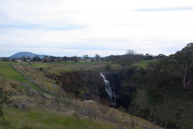
Photograph - Photograph - Colour, Clare Gervasoni, Lal Lal Falls, Victoria, 2014, 09/2014
Lal Lal Falls Reserve contains one of the most spectacular waterfalls in the Moorabool Shite. The watefall is part of the on Lal Lal Creek, a tributary of the Moorabool River. and plunges 30 metres from a high basalt column into a deep ravine. Culturally, the Falls are believed to be the earthly home of Bunjil, the All Father or Creator to most Victorian Aboriginal tribes. The name Lal Lal is thought to be Aboriginal for "dashing of waters". The Lal Lal Falls is listed on the Site Registry of Aboriginal Affairs Victoria as a spiritual place. in 1837 a Government Survey Party led by Frederick D'Arcy documented these Falls on the west branch of the Moorabool River. On the reserve opposite, a Race Meeting was held on every New Years Day from 1860 until 1938, attracting crowds of up to 20,000 people. A branch Railway Line was constructed from the Lal Lal station to the Racecourse to convey the crowds.Colour photographs of Lal Lal Falls near Ballarat, Victoria.lal lal falls, waterfall, lal lal, bunjil -
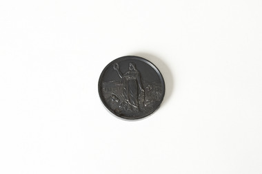 Chiltern Athenaeum Trust
Medal, Royal Agricultural Society of Victoria, 1895
Wilfred Clarence Busse was born in Chiltern, Victoria in 1898. His family first arrived in this region during the gold rush era, purchasing a piece of land adjacent to the Murray River. The spectacular scenery and rich history of the area is said to have inspired Busse in his writing. He attended Wesley College in his school days, before going on to study law at the University of Melbourne. After graduating from university, Busse would go on to become a barrister, but he is best known as a writer of fiction, publishing two novels: 'The Blue Beyond: A Romance of the Early Days in South Eastern Australia' and 'The Golden Plague: A Romance in the Early Fifties'. Busse died in 1960. This particular object is dated 1895, three years before Busse was born. It can thus be assumed that it was awarded to a relative of his, possibly his father in relation to their land by the Murray River. This object is significant as it is associated with Wilfred Clarence Busse, a celebrated author and barrister who grew up in the locality of Chiltern. It is also a medal awarded by the Royal Agricultural Society of Victoria, a society that has held social and industrial significance since it was founded in the nineteenth century. Small, circular medal - made of either bronze or brass metal - depicting an agricultural background behind a female figure in a toga holding a wreath. Back side: The Royal Agricultural Society of Victoria / Busse & Son / 1895wilfred clarence busse, w.c. busse, busse, gold rush, gold rush chiltern, busse author, the royal agricultural society of victoria, "the golden plague: a romance of the early fifties., "the blue beyond, rasv, medal, agricultural medal -
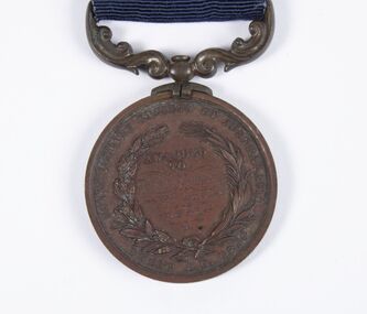 Bacchus Marsh & District Historical Society
Medal, Royal Humane Society of Australasia Medal Awarded to Thomas Kennedy 3rd August 1891
Thomas Kennedy aged 14 was awarded this medal in 1892 for the bravery he showed in rescuing members of his family from the flooded Werribee River on the 3rd August 1891. The Bacchus Marsh Express newspaper on for 30 July 1892, page 2, reported the awards ceremony with this description, 'Bronze medals of the Royal Humane Society of Australasia were awarded at the Melbourne Town Hall on Monday evening as follows: Thomas Kennedy, of Maddingley, near Bacchus Marsh, aged 14 years, for the risk he incurred in procuring assistance to rescue his father, mother, four brothers and sisters from being drowned during the flood of the Werribee River, on the 3rd August, 1891. He at daybreak swam across a strong current, and procured a boat, then rode a horse attached by a chain to the boat, and was returning thus to the house when he was washed off the horse, and with much difficulty rescued'. Bronze medal with ribbon.Obverse: Virtute Paratum; Reverse: Awarded to Thomas Kennedy 3rd Aug 1891, Royal Humane Society of Australasia, INSTD. A.D. 1874medals, awards, floods 1891 -
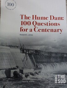 Wodonga & District Historical Society Inc
Book - The Hume Dam: 100 Questions for a Centenary, Howard C Jones, 2019
A booklet describing the history of the Hume Dam in question-and-answer format, illustrated by photographs from the Albury City Collection and other sources. This booklet was produced to accompany the exhibition "Turning the sod: building the Hume Dam", on display at Lavington Library from 21 December 2019 -1 March 2020."non-fictionA booklet describing the history of the Hume Dam in question-and-answer format, illustrated by photographs from the Albury City Collection and other sources. This booklet was produced to accompany the exhibition "Turning the sod: building the Hume Dam", on display at Lavington Library from 21 December 2019 -1 March 2020." hume dam, dams -- new south wales, hume dam history, dams -- new south wales -- design and construction -
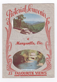 Marysville & District Historical Society
Postcard (item) - Colour and black and white photographs, Murray Views, Pictorial Souvenur of Marysville, Vic. 15 Favourite Views, 1950's
A fold out postcard of 15 colour and black and white photographs of scenes and landscapes in and around Marysville in Victoria.A fold out postcard of 15 colour and black and white photographs of scenes and landscapes in and around Marysville in Victoria. These photographs were produced by Murray Views in Gympie, Queensland as a souvenir of Marysville.Pictorial Souvenir/ of/ Marysville, Vic./ 15 Favourite Views PRODUCED BY MURRAY VIEWS. GYMPIE. Q. COPYRIGHT SAMUEL LEE & CO., PRINTERS Serial No. R 4152 NICHOLL'S LOOKOUT, MARYSVILLE, VIC. TAGGERTY RIVER, MARYSVILLE, VIC ROAD SCENE, MARYSVILLE, VIC. MAIN STREET, MARYSVILLE, VIC. THE CROSSWAYS, MARYSVILLE, VIC. FRUIT SALAD FARM, MARYSVILLE, VIC. ROAD TO CUMBERLAND VALLEY, MARYSVILLE, VIC. CROSSWAYS CABARET, MARYSVILLE, VIC. TREE FERNS, MARYSVILLE, VIC. STEVENSON'S FALLS, MARYSVILLE, VIC. Looking towards Marysville, Vic. Tourists at Marysville, Vic. Taggerty River, Marysville, Vic. On Buxton Road, Marysville, Vic. Panorama from Black Spur, Marysville Road, Marysville, Vic.marysville, victoria, souvenir, postcard, nicholl's lookout (image 1), taggerty river (image 2), road scene (image 3), main street marysville (image 4), crossways hotel (image 5), fruit salad farm (image 6), cumberland valley (image 7), crossways cabaret (image 8), tree ferns (image 9), steavenson falls (image 10), marysville view (image 11), tourists marysville (image 12), taggerty river (image 13), buxton road (image 14), black spur (image 15) -
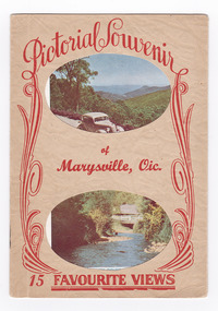 Marysville & District Historical Society
Postcard (item) - Colour and black and white photographs, Pictorial Souvenir of Marysville, Vic. 15 Favourite Views
A fold out postcard of 15 colour and black and white photographs of scenes and landscapes in and around Marysville in Victoria.A fold out postcard of 15 colour and black and white photographs of scenes and landscapes in and around Marysville in Victoria. These photographs were produced by Murray Views in Gympie, Queensland as a souvenir of Marysville.Pictorial Souvenir/ of/ Marysville, Vic./ 15 Favourite Views PRODUCED BY MURRAY VIEWS. GYMPIE. Q. COPYRIGHT SAMUEL LEE & CO., PRINTERS Serial No. R 4152 NICHOLL'S LOOKOUT, MARYSVILLE, VIC. TAGGERTY RIVER, MARYSVILLE, VIC ROAD SCENE, MARYSVILLE, VIC. MAIN STREET, MARYSVILLE, VIC. THE CROSSWAYS, MARYSVILLE, VIC. FRUIT SALAD FARM, MARYSVILLE, VIC. ROAD TO CUMBERLAND VALLEY, MARYSVILLE, VIC. CROSSWAYS CABARET, MARYSVILLE, VIC. TREE FERNS, MARYSVILLE, VIC. STEVENSON'S FALLS, MARYSVILLE, VIC. Looking towards Marysville, Vic. Tourists at Marysville, Vic. Taggerty River, Marysville, Vic. On Buxton Road, Marysville, Vic. Panorama from Black Spur, Marysville Road, Marysville, Vic.marysville, victoria, souvenir, postcard, nicholl's lookout (image 1), taggerty river (image 2), road scene (image 3), main street marysville (image 4), crossways hotel (image 5), fruit salad farm (image 6), cumberland valley (image 7), crossways cabaret (image 8), tree ferns (image 9), steavenson falls (image 10), marysville view (image 11), tourists marysville (image 12), taggerty river (image 13), buxton road (image 14), black spur (image 15) -
![Scene on the Yarra, near Rourke's Bridge / [by] Nicholas Caire, circa 1876](/media/collectors/550653872162f11fb04854aa/items/5777571cd0cdd10a5c191a9c/item-media/57775788d0cdd10a5c193e0d/item-fit-380x285.jpg) Kew Historical Society Inc
Kew Historical Society IncPhotograph, Anglo-Australasian Photographic Company, Scene on the Yarra, near Rourke's Bridge, c. 1876
Nicholas Caire was born on Guernsey in the Channel Islands in 1837. He arrived in Adelaide with his parents in about 1860. In 1867, following photographic journeys in Gippsland, he opened a studio in Adelaide. From 1870 to 1876 he lived and worked in Talbot in Central Victoria. In 1876 he purchased T. F. Chuck's studios in the Royal Arcade Melbourne. In 1885, following the introduction of dry plate photography, he began a series of landscape series, which were commercially successful. As a photographer, he travelled extensively through Victoria, photographing places few of his contemporaries had previously seen. He died in 1918. Reference: Jack Cato, 'Caire, Nicholas John (1837–1918)', Australian Dictionary of BiographyAn original, rare photograph from the series 'Views of Victoria: General Series' by the photographer, Nicholas Caire (1837-1918). The series of 60 photographs that comprise the series was issued c. 1876 and reinforced a neo-Romantic view of the Australian landscape to which a growing nationalist movement would respond. Nicholas Caire was active as a photographer in Australia from 1858 until his death in 1918. His vision of the Australian bush and pioneer life had a counterpart in the works of Henry Lawson and other nationalist poets, authors and painters.Albumen silver photograph mounted on boardprinted in ink on support l.c.: SCENE ON THE YARRA, NEAR ROURKE'S BRIDGE. / COPYRIGHT REGISTERED. printed in ink on support reverse c.: VIEWS OF VICTORIA. / (GENERAL SERIES.) / No. 16. / SCENE ON THE YARRA, NEAR ROURKE'S BRIDGE. / The subject of the present illustration represents the New Bridge crossing the River Yarra on the road from / St. Huberts to the Native Station at Corranderrk, and to the township at Healesville. The river at this place abounds / with fish of a large description, which are caught by the Natives, frequently in considerable quantitities. printed in ink on support reverse l.c.l.: J.W. FORBES, Agent, printed in ink on support reverse l.c.: ANGLO-AUSTRALASIAN PHOTOGRAPHIC COMPANY, MELBOURNE. printed in ink on support reverse l.c.r.: 10 Temple Court, Collins Street West.nicholas caire (1837-1918), landscape photography - victoria -
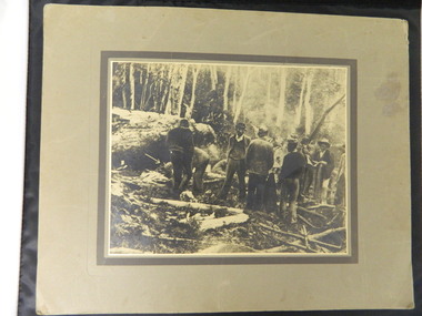 Kiewa Valley Historical Society
Photo - Cleve Cole
This photo depicts the rescue of three local skiets that became trapped on Mt Bogong during a blizzard and became known as the Cleve Cole tragedy . Mick Hull Howard Michell and Cleve Cole where skiing on Mt Bogong and could not find their way off the mountain via Staircase Spur due to Blizzard conditions and ended up in the Mitta Valley. Howard Michell walked to the Battys farm to get help for his weak and injured friends. Cleve Cole died shortly after arriving at Omeo hospital. This photo is historically significant as it tells the rescue story of this tragedy. The photos are of the people involved which add to the story. Mt Bogong Victoria's highest mountain is accessed from the Kiewa Valley and near by high plains and over shadows Mt Beauty township therefore is a local story. The photo comes from the rescue party which is a rare photo and thus has great interpretive capacity . The skiing history is one of KVHS main themes and this photo is part of our Skiing Across Country exhibitionBlack and white photo of several men in the bush near Mt Bogong. Photo is glued on to cardboard with a dark grey border and light grey wider border on the outside.Handwritten on back "The Discovery of Cleve Cole / up the Big River (Below Paddy's Flat) / Cole is arrowed / Cyril Rootsey / Jack Batty / Bill Batty / Paul? Bitner / Tom Fitzgerald / Etc. / (I think dad is the one with his hand up to his face)" Back - red stamp - "Herald Feature / Service / Melbournecleve cole. mt bogong. big river. paddy's flat. -
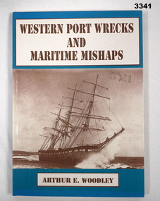 Bendigo Military Museum
Book - BOOK, MARITIME, Arthur E Woodley, Western Port Wrecks & Maritime Mishaps, 1992
Soft cardboard cover. Brown print on front & spine, black print on back. Background colour aquamarine with front sepia photo of sailing ship. Back has 2 photos of the Cowes ferry. 103 pages, cut plain, off white. Illustrated with black & white photos & maps. Page XV has yellow highlighter pen applied to 2 sentences. Opposite p1, handwritten in blue ink on lined notepaper taped to page: “MIRANDA 1852, LADY MILDRED 1909, SEAGULL, CARPENTARIA, AT. * HARDWOOD. AIR. PORT, AMSTERDAM. FIVE (BEACHED), BUILT 1948. WORKED, YARRA RIVER, DIESEL MOTORS TOO BE RESTORED, * TOORADIN”book, maritime, wrecks, western port -
![Straus’ Falls, Cape Otway Ranges / [by] Nicholas Caire, circa 1876](/media/collectors/550653872162f11fb04854aa/items/57833e2ad0cdd1176c6791eb/item-media/57833ea7d0cdd1176c67b9d8/item-fit-380x285.jpg) Kew Historical Society Inc
Kew Historical Society IncPhotograph, Anglo-Australasian Photographic Company, Straus’ Falls, Cape Otway Ranges, c. 1876
Nicholas Caire was born on Guernsey in the Channel Islands in 1837. He arrived in Adelaide with his parents in about 1860. In 1867, following photographic journeys in Gippsland, he opened a studio in Adelaide. From 1870 to 1876 he lived and worked in Talbot in Central Victoria. In 1876 he purchased T. F. Chuck's studios in the Royal Arcade Melbourne. In 1885, following the introduction of dry plate photography, he began a series of landscape series, which were commercially successful. As a photographer, he travelled extensively through Victoria, photographing places few of his contemporaries had previously seen. He died in 1918. Reference: Jack Cato, 'Caire, Nicholas John (1837–1918)', Australian Dictionary of Biography.An original, rare photograph from the series 'Views of Victoria: General Series' by the photographer, Nicholas Caire (1837-1918). The 60 photographs that comprise the series were issued c. 1876 and reinforced a neo-Romantic view of the Australian landscape to which a growing nationalist movement would respond. Nicholas Caire was active as a photographer in Australia from 1858 until his death in 1918. His vision of the Australian bush and pioneer life had a counterpart in the works of Henry Lawson and other nationalist poets, authors and painters.‘Straus’ Falls, Cape Otway Ranges’ : Views of Victoria (General Series) No.55 : Albumen silver photograph | Photo on card with Title and Description on reverse | Mounted 24 x 30 cm; Photo 12 x 17 cm.On Reverse: ‘These Falls were discovered some time since by a gentleman named Straus, and were so named in memory of him. They comprise a succession of falls, rapids, and cataracts varying from 10 feet to 60 feet, making a total of 250 feet from the fall to the bed of the stream. These waters probably form a tributary to one of the adjacent rivers.’nicholas caire (1837-1918), landscape photography -
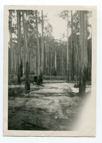 Orbost & District Historical Society
black and white photograph, 1939
Buldah School was No. 4555. Mrs L. Petterson made application for a school at Buldah during 1936. It was opened on 8th of August 1937 by Herbert H. Eynstone acting as Head Teacher. He held this position for only about two weeks. The school closed during 1941. The Petterson brothers were early settlers in Cann River - late 19th century. This is a pictorial record of a school route in the first half of the 20th century. The Buldah School no longer exists.A black / white photograph of a bush track in a forest. There is water running across the track.on back - Don. by Mrs D. Petterson, only track to Buldah School in winter 1939...."buldah-east-gippsland -
 Port of Echuca
Black and white photograph
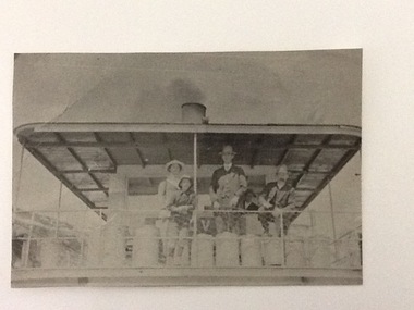
A copy of a black and white photograph of paddle steamer travel along the Murray river. It shows passengers (2 men, 1 girl, 1 boy) on the upper deck of the P. S. Kelvin, around the late 1890-1900. In the background is a third man, Hugh Price, at the wheel of the paddlesteamer. On the back of the photograph is documented as being on the mail run and at the Murray Bridge.Demonstrates passenger transport and travel along the river as well as the delivery of mail services between rural communities around the Murray Bridge, Blanchetown region in South Australia around 1890-1900.Copy of a Black and white photograph of 2 men, 1 girl and 1 boy on upper deck of P. S. Kelvin. In background is a 3rd man, Hugh Price, at the wheel. Documented as being on mail run and at the Murray Bridge (at Echuca)Kelvin on mail run, Murray Bridge. Hugh Price at wheel in rear.murray bridge south australia, p.s. kelvin, mail run, hugh price, cargo, price family collection -
 Port of Echuca
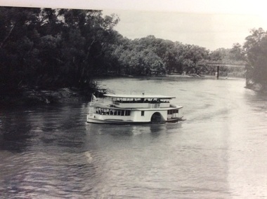
Black and white photograph, Mid 20th Century
The P.S Canberra was built in 1912 at Goolwa South Australia by David Milne. It was built as a fishing vessel. It was originally a steam engine, reverted to diesel, but was returned to steam in 1995. It is currently owned by the Murray Steam Ship and Tourist Co. and has operated as a tourist vessel at Echuca Since 1967. (Ref Parsons, R "Ships of the Inland Rivers " p. 58)The P.S Canberra is significant as it has operated as a tourist vessel since 1967, and continues to do so. A black and white photograph of the P.S.Canberra coming downstream from the iron bridge at Echuca.On boat the words Canberra.p.s canberra, murray steam ship & tourist company