Showing 750 items matching "chart"
-
 Geoffrey Kaye Museum of Anaesthetic History
Photograph
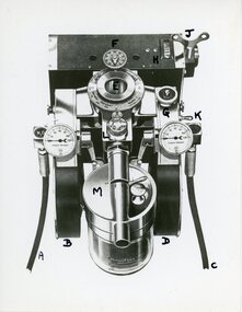
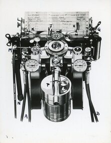
The McKesson Nargraf anaesthetic record was introduced in 1930, created by Dr Elmer I. McKesson.Black and white photograph of a drawing of the head of a McKesson Nargraf anaesthetic record, Model J. The view is from the top looking down onto the machine, showing a round vaporiser with a valve attached to it and two round pressure gauges on either side. The recorder on the top of the photograph does not have a chart attached to it.Each part of the machine has been labelled and handwritten in black ink the letters A - H and J - M on the surface.mckesson nargraf anaesthetic record, anaesthetic equipment -
 Flagstaff Hill Maritime Museum and Village
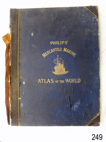
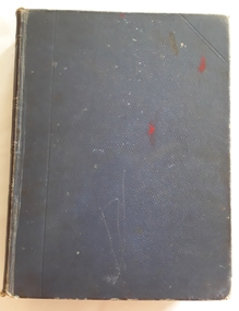
Book - Atlas, George Philip & Son Ltd, The London Geographical Institute, Philips' Mercantile Marine Atlas, 1904
Philips' Mercantile Marine Atlas of the World contains a series of 30 plates containing over 100 charts and plans, with tables of over 8,600 distances between ports, national and house flags, lists of British & United States Consulates and a complete index of 20,000 ports. Specially designed for merchant shippers, exporters and ocean travellers, and for general use. The atlas is significant as a record of the status of world statistics in 1904, of interest to travelers, merchants, and world traders. "Philips' Mercantile Marine Atlas of the World". Dark blue hardcover, gold embossing and trim. Edited by George Philip, F.R.G.S. Second edition. Published in London by George Philip & Son, London, Date: 1904 Inscription on a purple stamp on the fly page."Please - - - / HARDY GILLARD / - - / - - LONDON"flagstaff hill, warrnambool, flagstaff hill maritime museum and village, shipwreck coast, great ocean road, atlas, marine atlas, philip's mercantile marine atlas, ports, flags, consulates, ocean travellers, shipppers, merchants, 1904 -
 Vision Australia
Functional object - Object, Royal National Institute for the Blind, Tactile yellow ruler
30 cm tactile yellow ruler with black marking every 5 centimeters with raised markings, has two different edges - straight and notched. The straight edge can be used for measuring and drawing, and the notched edge designed to help place pins when creating charts and graphs or using a compass. There are non-slip pads on the back of the ruler. 1 yellow ruler with black large print numbers and black measurement indicatorsRNIB LT21 (on back)assistive devices, royal national institute for the blind -
 Melbourne Legacy
Document, Future of Residences Sequence of Proposed Developments
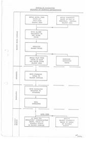
The Steering Committee Residences developed this PERT (Programme Evaluation Review Technique) as noted in a memo dated 28.5.74 written by Chairman Legatee Quayle (Cat. No. 01689). The chart shows the sequence of developments for rationalising Blamey House, Stanhope, and Harelands, and potentially allowing for the long term transitioning of Blamey House into accommodation for elderly widows; this was never carried out. Gives an insight into Legacy thinking about the way in which the residences should be used.White foolscap photocopy, black type on white. Two holes punched for filing. In ink bottom right hand side 'HR 3/4/74' This would have been Legatee Rodgers.residences, blamey house, stanhope, harelands -
 Bendigo Military Museum
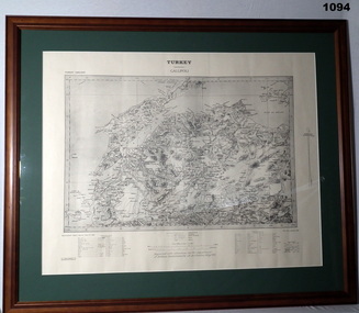
Map - MAP GALLIPOLI, FRAMED
Brown, wooden frame with glass front, white cardboard backing, map mounted with green border. Map of Gallipoli area in black & light grey with white border. A detailed map of Turkey area around Dardanelles with references & scale charts at bottom. Reprinted for the Department of Defence, Commonwealth of Australia, May 1915.Front Top Centre: Turkey, Gallipoli. Rear: Bethany Gallery stamp.documents - maps, military history, gallipoli -
 Flagstaff Hill Maritime Museum and Village
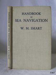
Book - Reference guide, William Marshall Smart (W M Smart), Professor of Astronomy, A Handbook of Sea Navigation, 1943
Author W M Smart, M.A., D.SC., F.R.A.S. (William Marshall Smart), (1889-1975) Regius Professor of Astronomy in the University of Glasgow, Instructor-Lieut. in the Royal Navy during World War I. and John Couch Adams Astronomer in the University of Cambridge. In 1943 he was elected as a fellow of the Royal Society of Edinburg. From 1949-1951 he was President of the Royal Astronomical Society and a member of the Royal Institute of Navigation. In 1958 he was awarded the Lorimer Medal of the Astronomical Society of Edinburgh. The publisher firm, Longmans, Green & Co, was originally founded in 1724 in London by Thomas Longman under the name Longman. In August of that year, he bought the two shops and goods of William Taylor and set up his publishing house there at 39 Paternoster Row. The shops were called Black Swan and Ship, and it is said that the 'ship' sign was the inspiration for Longman's Logo. After many changes of name and management, the firm was incorporated in 1926 as Longmans, Green & Co. Pty Ltd. The firm was acquired by Pearson in 1968 and was known as Pearson Longman or Pearson PLC. The book was sold by Collins Book Depot which was founded by Frederick Henry (Harry) Slamen in 1922. In 1929 the form became a Proprietary Limited Company with an additional two stores, at 95 Elizabeth and 361 Swanston Streets, Melbourne. Collins Booksellers is still owned by the Stamen family. It is the largest Australian-owned bookselling chain.The book is significant due to its connection with navigation at sea. Its author W M Smart was a learned astronomer and an Instructor-Lieutenant for the Royal Navy during World War I. His achievements were recognised in 1958 when he was awarded the Lorimer Medal of the Astronomical Society of Edinburgh.A Handbook of Sea Navigation: The Theory & Practice of Astronomical Navigation at Sea, with diagrams and charts Author: W M Smart, M.A., D.SC., F.R.A.S. (William Marshall Smart) Publisher: Longmans, Green and Co Printer: Collins Book Depot Date: 1943 Textured green hardcover book. Inscriptions on the Fly page.Pencil: "12/6" [12 shillings 6 pence] Sticker: "G.F. Byrne / Faunce Crescent / O'Connor, A.C.T. / Australia 2001" Stamp: "COLLINS BOOK DEPOT PTY. LTD. / Technical Book Department / 361 Swanston St., Melb. G - - -"flagstaff hill, flagstaff hill maritime museum and village, warrnambool, maritime museum, maritime village, great ocean road, shipwreck coast, longmans green and co., thomas longman, paternoster row london, w m smart, william marshall smart, astronomer, navigator, professor of astronomy, 1943, g.f. byrne, collins book depot, technical book department, 361 swanston st., melbourne, frederick henry (harry) slamen, 361 swanston street melbourne, a handbook of sea navigation, maritime handbook, navigation instructiono, sea navigation -
 Bendigo Military Museum
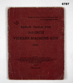
Manual - RANGE TABLE FOR .303 inch VICKERS MACHINE GUN, HM Stationary Office, C.1937
Items in the collection re Lt Col J. Swatton, refer Cat No 6719.2P for his service details. This is a small pocket size booklet. Cover is red buckram. It has 14 pages printed of words and range charts. There are 3 blank sheets as well. Printed on the front cover is the title as above. A note refers to Army orders Feb 1937. There are some drawings of flags at mast head to indicate wind speed.Written inside front cover in pencil. "P.I.M.S.L.R.O". (+ something illegible). Written on back cover, in pencil, "Miss A Parker, 170 Forest 1487". On the outside rear is a sticky label with the words - "On loan from the Estate of Colonel J.W. Swatton Ref No. JWS M/!"passchendaele barracks trust, machine gun, vickers -
 Bendigo Military Museum
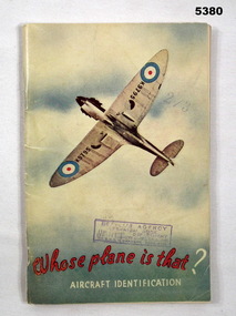
Booklet - BOOKLET, AVIATION, Whitcombe & Tombs Pty Ltd, Whose Aeroplane is That?, 1943
Refers to the service of LAC Lance & Percy Coates.This is a booklet with a light cardboard cover, fastened with 2 staples. On the front is an underside view of a spitfire in flight. (Probably an MK1). It has RAF roundels. The phrase "Whose plane is that?" is printed in red ink. The phrase "Aircraft Identification" is in white ink. Inside are 53 pages of Aircraft photos, data and charts of the various warring nations. The front cover has a rubber stamp of McGills Agency, Melbourne.ww2, aircraft -
 Bendigo Historical Society Inc.
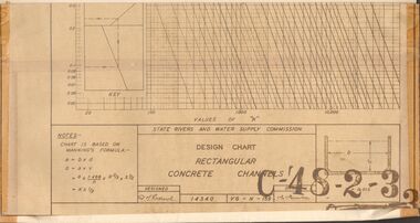
Document - STATE RIVERS AND WATER SUPPLY COMMISSION : DESIGN CHART RECTANGULAR CONCRETE CHANNELS
State Rivers and Water Supply Commission. Coliban System. Lake Eppalock construction. Design chart of Rectangular Concrete Channels (42cm x 63.5cm) is stamped C-'48-2-3. Attached is a page labelled Open Channel Flow Diagram (33cm x 42cm), stamped C-'49-2-3.state infrastructure, water supply, coliban system, state rivers and water supply commission. coliban system. lake eppalock. -
 Mont De Lancey
Book, Robert Wolstenholme Holland, Pitman's Commercial Self-Educator - A Comprehensive Guide to Business - Volume 11, 1922
non fictionLarge plain blue hardcover book, Pitman's Commercial Self-Educator with diagonal triangle markings on top and bottom of cover front and back. Spine has gold lettering for title, and edited by R.W. Holland O.B.E., M.A., M.Sc.., LL.D. Pitman with gold bands. Contains photographs, diagrams, maps, charts, drawingsFrom Don Gaudion. On endpaper at back of book pencil name, Marcus Stevenson'sbusiness, study guide, commercial reference, non fiction book -
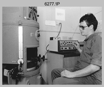 Bendigo Military Museum
Photograph - Map Production and Technical Services – Army Survey Regiment, Fortuna, Bendigo, July 1986
This is a collection of six photos of personnel and civilians undertaking technical tasks from Technical Services and the Air Survey, Cartographic and Lithographic Squadrons. The photos were taken at the Army Survey Regiment, Fortuna, Bendigo in July 1986. This is a set of six photographs of Army Survey Regiment personnel and civilians undertaking technical activities at Fortuna, Bendigo, in July 1986. The photographs were printed on photographic paper and are part of the Army Survey Regiment’s Collection. The photographs were scanned at 300 dpi. .1) - Photo, black & white, 1986, BARCRO work area WILD U4A Diapositive Camera, SPR Rob Jones. .2) - Photo, black & white, 1986, Aerotriangulation work area, SSGT Greg Buckingham. .3) - Photo, black & white, 1986, Technical Services in Building 16A. L to R: SSGT Andy Wilson, Tony Spurling, Pat Thwaites. .4) - Photo, black & white, 1986, RAAF Charting, L to R: SGT Paul Leskovec, SPR Toni Martin, FLT LT Don Stebbings .5) - Photo, black & white, 1986, Camera Section, CPL John Whaling. .6) - Photo, black & white, 1986, Print Troop, SPR Daryl South..1P – Annotated on back ‘JUL 86 SPR Rob Jones Barcro’ .2P – Annotated on back ‘JUL 86 SSGT Greg Buckingham Aerotrig’ .3P – Annotated on back ‘JUL 86 SSGT Andy Wilson, Mr Tony Spurling, Mr Pat Thwaites. Tech Services’ .4P – Annotated on back ‘JUL 86 SGT Paul Leskovec CSM, SPR Tony Martin, FLT LT Don Stebbings RAAF Charting’ .5P – Annotated on back ‘JUL 86 CPL John ‘Junior’ Whaling Camera Section LITHO’ .6P – Annotated on back ‘JUL 86 SPR Daryl South LITHO SQN’royal australian survey corps, rasvy, army survey regiment, army svy regt, fortuna, asr, air survey, litho, carto -
 Bendigo Historical Society Inc.
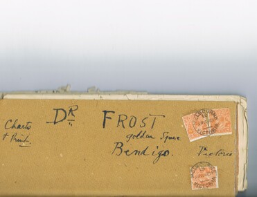
Document - MCCOLL, RANKIN AND STANISTREET COLLECTION: DR FROST, 1920
Correspondence to Dr. Frost re Badak Tin Mine. Binti Binti, Sweet Nell, Bettina, Mascotte & Maconi. Report on inspection of mine reports by Mr. M. Sheard (Mine Manager) & Dr. C. W. Laver of Kalgoorlie, map of Binti lease. Des Frost Golden Square Bendigo Victoria, charts and print.MCCOLL RANKIN & STANISTREETorganization, business, gold mining, mccoll rankin & stanistreet -
 National Wool Museum
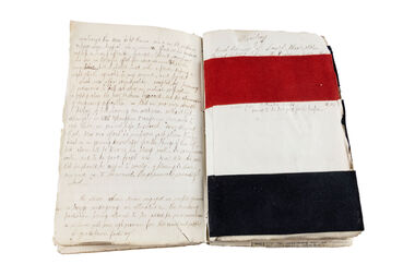
Journal, John Fraser, 1872
Journal written by John Fraser. Fraser's family migrated from Scotland in the 1850s on sailing vessel 'Countess of Cawdor' charted by a group of passengers for travel to Australia. John worked at the Victorian Woollen Mill, Geelong, and kept a diary of sample of cloth, people and happenings in Geelong from 1872. John was aged 6 months and 16 years when he began writing the journal. Book has a black cover which no longer covers all pages due to sample cloth and sheets of paper additionally being stuck into the book, making it too large/thick for the cover. Book shows signs of age particularly though fragile spine of the book and the discolouration of the internal pages. Book is starting to split at the spine, particularly from the bottom of the spine up and has visible signs of age on the black cover. Spots of missing leather are particularly visible on the front, centre right portion of the cover. Additional spots of missing leather dot the surrounding portions of the front and rear covers of the book.geelong, wool, textile design -
 Bendigo Military Museum
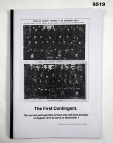
Booklet - MILITARY SERVICE WW1, Murray Poustie, "The First Contingent", 2013
From the title page; "The First Contingent"/ The service and sacrifice of men who left from Bendigo/ in August 1914 to serve in World War 1". "- containing details of how and when they volunteered/ and enlisted, when they embarked from Melbourne, and what happened to them".Booklet - facsimile copy. Soft cover - front and back clear plastic A4 sheet protecting title page which has black colour print, illustrated with two black and white group photographs. Black plastic spine. 49 pages - cut, plain A4 white paper. Illustrated with black and white photographs and charts.publications, booklets, military service, ww1, bendigo -
 Melbourne Tram Museum
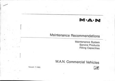
Manual, MAN, "MAN Maintenance recommendations 1985", Jul. 1985
Set of two manuals for MAN buses: .1 - MAN Maintenance recommendations 1985 - 25 A4 pages, landscape stapled in the top left hand corner - issued 7/1985. Photocopied from a MAN book. .2 - Chart of MAN recommended fuels and lubricants - 2 A4 sheets, stapled in the top left hand corner.Has "MAN" in ink on top edge.trams, tramways, buses, maintenance, man, manual -
 Melbourne Tram Museum
Document - Report, Melbourne & Metropolitan Tramways Board (MMTB), "Passenger movements by public transport for the Central city Business area based on results of the 1964 Melbourne Metropolitan Transportation Study, Nov. 1965
Report - Foolscap landscape format, red tape binding - approx. 80 pages with notes, diagrams, charts, maps showing passenger traffic for parts of each route, including Railway Stations, passenger flows, titled "Passenger movements by public transport for the Central city Business area based on results of the 1964 Melbourne Metropolitan Transportation Study.In top right hand corner "Lees" in inktrams, tramways, mmtb, tramways, melbourne, surveys, passengers, railways, maps -
 Bendigo Military Museum
Photograph - Detachment - Army Survey Regiment, Bonegilla, Victoria, c1973
This is a set of six photographs of personnel from the Detachment - Army Survey Regiment taken in front of its main map production building at Bonegilla, Victoria in c1973. This cartographic map production sub-unit of the Army Survey Regiment operated in buildings owned by the School of Military Survey from 17th of June 1970 to the 30th of September 1985. A total of 800 topographic maps ranging in scale from 1:25,000 to 1: 250,000 scale were completed. A major focus of production in the 1970s was the cartographic completion of the Papua-New Guinea 1:100,000 map series and the Flexiflow quality control system was developed as a tool to coordinate production. The Flexiflow system comprised a series of job plans and charts linked to a task allocation to resource magnetic planning board. Using critical path analysis and task prioritisation, complex job planning was efficiently scheduled, and re-prioritisations readily made. Reproduction requirements were effectively coordinated by way of weekly courier to the Army Survey Regiment at Bendigo. Supervisors and technicians fully embraced the system as they could understand their role, others around them and the positive production achievements. WO1 Bill Boyd (who does not appear in this photograph) was the technical warrant officer for 11 years at the Detachment was awarded the OAM, the Order of Australia Medal for leading the development and the implementation of the Flexiflow system. By mid-1982, production of maps at these scales was undertaken digitally on Bendigo’s AUTOMAP 2 system and the Detachment reverted to production of small-scale large format RAAF aeronautical charts. Detachment personnel managed to produce 18 charts in the following two years, which was an impressive achievement for the staff, given major differences in format, specification and scales. Development of digital production of aeronautical charts in 1984-85 led to gradual reduction in production output and contracting out production was instigated to meet the shortfall and as a consequence the Detachment closed in September 1985. See pages 177 to 180 of Valerie Lovejoy’s book 'Mapmakers of Fortuna – A history of the Army Survey Regiment’ ISBN: 0-646-42120-4. for more information on the history of the Detachment at Bonegilla.This is a set of six photographs of the Detachment - Army Survey Regiment taken in front of the main map production building at Bonegilla, Victoria in c1973. The photographs were printed on photographic paper and are part of the Army Survey Regiment’s Collection. The photographic print and proofs were scanned at 600 dpi. .1) to .3) - Photo, black & white c1973. Back Row L to R: Peter Simpson, Chris Edwards, unidentified (x2), Colin Harden, Rowan Gillies, Bob Rowley OAM, Steve Hansen, Stu Thaxter. Centre Row L to R: Kevin Boehm, Dennis McCarthy, Peter Cross, unidentified, Brian Ryan, unidentified, Ian Marner, unidentified, Phil Smalley. Front Row L to R: Geoff Haynes, Bruce Wetzig, Dave Thompson, unidentified, OC Bob Roche, Ike Lever, John McCulloch, Dick Barwald, unidentified. .4) - Photo, black & white c1973. Back Row L to R: Peter Simpson, Chris Edwards, unidentified (x2), Colin Harden, Rowan Gillies, Bob Rowley OAM, Steve Hansen, Stu Thaxter. Centre Row L to R: Kevin Boehm, Dennis McCarthy, Peter Cross, unidentified, Brian Ryan, unidentified, Ian Marner, Phil Smalley, unidentified, Dick Barwald. Front Row L to R: Geoff Haynes, Bruce Wetzig, Dave Thompson, unidentified, OC Bob Roche, Ike Lever, John McCulloch, unidentified (x2). .5) - Photo, black & white c1973. Back Row L to R: Geoff Haynes, unidentified, John McCulloch, Bruce Wetzig. Front Row L to R: Dave Thompson, Ike Lever, unidentified. .6) - Photo, black & white c1973. L to R: OC Bob Roche, unidentified.There are no personnel annotated.royal australian survey corps, rasvy, army survey regiment, detachment - army survey regiment, army svy regt, asr -
 Bendigo Military Museum
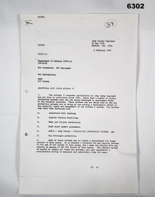
Letter - Army Survey Regiment - Letter of request for additional computer disk space for Automap 2, Army Survey Regiment, 19 Feb 1987
Automap 2 was the Army Survey Regiment's computerized Mapping system. This letter is a request for an additional 700 Mb of computer disk space for the Automap 2 System because of newly developed applications. Those applications were: Analytical Hill shading, Digital Terrain Modelling, Mask and stipple Production, RAAF Chart symbol Placement, ASTIS - Army Survey - Topographic Information System, and, Map Catalog Production.Two page letter, foolscap size, Stapled top left corner"A Spurling, Computer Operations Manager for CO"royal australian survey corps, rasvy, fortuna, army survey regiment, army svy regt, asr -
 Unions Ballarat
The nineteenth century: A history (Don Woodward Collection), Mackenzie, Robert, 1889?
Contents: - The opening of the Century - Napoleon Bonaparte - The Congress of Vienna - Social condition of Great Britain - The Reform Bill - The redress of wrongs - Chartism - Our wars - The victories of peace - Christian missions - The charities of the nineteenth century - Our Indian empire - Our colonies - France: The restored monarchy - France: The second empire - Germany - Austria-Hungary - Italy - Russia - Turkey - The United States of America - The Papacy - The progress of liberty in Europe Politics, history, religious and social customs - 19th Century Europe.Book; 475 pages. Cover: green background; 19th Century Library insignia; gold lettering; author's name and title. In black ink, "? ? Falconer, 19th July 1895".btlc, ballarat trades and labour council, ballarat trades hall, politics and government, social conditions, social customs, religion, foreign relations, warfare -
 Queenscliffe Maritime Museum
Equipment - Compass correctors, shadow pins and magnets
True North is at the centre of the north pole This is a fixed point at the top of the planet. The majority of our navigational charts are orientated so that they use true north as their reference point. This is because true north doesn’t move. Magnets don’t point towards true north however. They point toward magnetic north which is in a different geographical place. The difference in the angle between true north and magnetic north is call variation.Three wooden boxes containing magnetic compass quadrantal correctors, correcting magnets and shadow pins.Saura Keiki Seisakusho Co Ltdcompass, correcting magnets, magnetic variation -
 Forests Commission Retired Personnel Association (FCRPA)
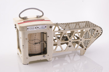
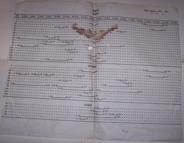
Thermo-hygrograph
Bushfire behaviour is influenced by many factors including temperature, relative humidity (RH), forest type, fuel quantity and fuel dryness, topography and even slope. Wind has a dominant effect on the Rate of Spread (ROS), as well as fire size, shape and direction. Temperature and relative humidity have major impacts on fuel dryness and therefore upon the availability of fuel for combustion. A thermo-hygrograph measures and records both temperature and humidity. It produces a continuous record by drawing ink traces on a paper chart held in revolving cylinder. Humidity is measured by shortening or lengthening of a bundle of specially treated human hair. Temperature is measured by means of a laminated bi-metal strip of temperature-sensitive metals which bend differentially with temperature change. The recording drum is driven by clockwork which may be geared for rotation intervals of daily, weekly or monthly periods. This particular instrument is a seven-day recorder. Serial number 10186 which probably dates from about 1960. The chart indicates it was last used in March 1979.Used for bushfire research.Clockwork Thermo-hygrographCasella London 10186 Made in England Research Branch. Forests Commission Orbostbushfire, forests commission victoria (fcv), forest measurement -
University of Melbourne, Burnley Campus Archives
Book - Register, Rainfall Registration, 1951-1983
Rainfall registration charts in a variety of forms recorded at Burnley. (1) 1 page handdrawn on cardboard, monthly and annual totals 1951-1978 (part). (2) 1974-1978 daily. (3) Unused forms. (4) 1980-1983. (5) Climatological Data for Melbourne up to 31st December 1964. Found in a folder labelled, "Burnley Weather Records." rainfall registration, weather reports, climatological data -
 Ballarat Tramway Museum
Document - Roster, State Electricity Commission of Victoria (SECV), "Stand By", 29/08/1966 12:00:00 AM
Demonstrates aspects of the Ballarat Tramways crewing arrangements, when standby's were available to cover crews who did not report in or left early or unavailable or running late. Allowed the inspectors to know when crews were available to cover late running etc. Produced for the Sept. 1966 rosterLarge format carbon copy typed sheet - titled "Stand by" dated 29th August 1966. Gives Run and time along the top heading and then broken up into each run for Weekdays, Saturdays and Sundays showing in a line chart form the standby times for each run, including conductors. Shows starting and finishing time of each standby shift.In the top right hand corner " BTPS 812" in black ink.trams, tramways, rosters, crews, stand by, ballarat, timetables -
Bendigo Historical Society Inc.
Book - 'Nursing in the 30's' by Isabel 'Spark' Gill
272-page soft cover book entitled 'Nursing in the 30's' Before Antibiotics, Immunization & Modern Technology. By Isabel 'Spark' Gill A comprehensive story of nursing in the 1930's, including B&W illustrations, photos, charts and bandages. First published 1998 by Curnow Street Trust, Ivanhoe, Victoria. Printed by Walker Printing, Kangaroo Flat Signed by the author in black pen. Isabel 'Spark' Gill 20/3/1998 on title page.nursing, bendigo hospital -
 Geoffrey Kaye Museum of Anaesthetic History
Photograph
The McKesson Nargraf anaesthetic record was introduced in 1930, created by Dr Elmer I. McKesson.Black and white photograph of a drawing of the head of a McKesson Nargraf anaesthetic record, Model J. The view is from the top looking down onto the machine, showing a round vaporiser with a valve attached to it and two round pressure gauges on either side. There are blood pressure tubes attached to the sides of the machine. The recorder on the top of the photograph has a chart attached to it with written details.Each part of the machine has been labelled and handwritten in black ink the letters A - H and J - P on the surface.mckesson nargraf anaesthetic record, anaesthetic equipment, anaesthetic apparatus -
Clunes Museum
Map - PLAN / MAP
.1 MAP, TOWN OF CLUNES, PARISH OF CLUNES, COUNTY OF TALBOT, STAMPED BOROUGH OF CLUNES .2 PLAN OF SUBDIVISION OF PART OF CLUNES COMMON, BOROUGH OF CLUNES, PARISH OF CLUNES,COUNTY OF TALBOT. P. CAMPBELL. ASSISTANT SURVEYOR, MARCH 1904 ON RIGHT HAND BOTTOM CORNER C71/1 CLUNES COMMON. MARKED: CHARTED R.L.A.7/2/57.1 PHOTO LITHOGRAPHED. DEPARTMENT OF LANDS AND SURVEY, MELBOURNE .2 PHOTO LITHOGRAPHED AT THE DEP. OF LANDS AND SURVEY, MELBOURNE PRICE 1/- 10.11.08map town of clunes, borough of clunes, parish of clunes, county of talbot -
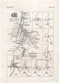 Ballarat Tramway Museum
Map - "Geelong tramways", Ken McCarthy, 1981
Map titled "Geelong tramways" prepared by Ken McCarthy Feb. 1981 showing the Geelong tram system with major street names, with a service frequency chart for weekdays in 1951 and 7 small maps showing the various stages of system development from 1912 to 1940. Has an insert for the depot layout. Produced for Ken's article on Geelong Tramways in the April 1981 issue of Trolley Wire, published by the Sydney Tram Museum.Yields information about the Geelong tram system and has a close association with Ken McCarthy.A4 printed sheet - from the April 1981 issue of Trolley Wire magazine.tramways, geelong, map, trolley wire -
 National Vietnam Veterans Museum (NVVM)
Document - Civil Affairs Unit speech 1967, Vietnam
Folder containing what appears to be an original typed text with hand-written notes and a copy of typed final text with the heading, "Vietnam". Seems to be the text of a speech given about the role of the civil Affairs Unit in Vietnam. Also a handwritten letter from L.K. Mackay dated 17 April 1969. Includes a chart of the structure of "The new government of Vietnam" dated November 1967vietnam - history, civil affairs unit, vietnam government, "revolutionary development" -
 Bendigo Historical Society Inc.
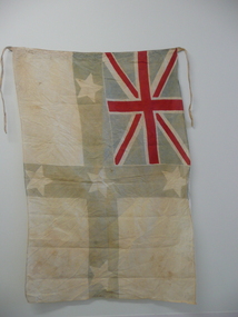
Flag
Flag identified by John Vaughan OAM, Vexillographer (Flag historian) [email protected] Flag has pale blue cross of St. George, with five, five pointed stars. Union Jack in top left hand corner. This flag is a variant of the 'Australian Federation Flag' often called the AUSTRALIAN ENSIGN, a popular design from 1831 to 1901 widely flown across Australia as a possible ’national’ flag. The Australian Ensign appeared in various forms for over a century with variant points to the stars (some with 5 points). A flag chart dated 31st December, 1831, and in subsequent charts, Captain John Nicholson, Harbour master of Sydney, depicted a new flag for Australia, featuring the combination of Southern Cross and Union Jack. The Southern Cross consisted of five eight pointed stars on a large royal blue St Georges Cross. It became the popular but unofficial flag of Australia for seventy years. In the 1890’s it was best known as the Australian Federation Flag. -
 Orbost & District Historical Society
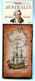
map, Shell Australia, 1970
This Shell road map was made as part of the 200 year celebration of Captain James Cook's voyage on the HM Endeavour and the first sighting of Australia at Point Hicks in 1770. The Bicentenary of James Cook in Australia was commemorated in Australia in 1970. The British explorer Lieutenant (later Captain) James Cook sailed and charted the East Coast of Australia in 1770, and claimed the eastern seaboard of the Continent for the British Crown. This was not considered the official bicentenary of Australia, but rather the mapping of the Eastern coastline. This item reflects the commemoration of a significant event in Australian history.A coloured foldout touring map of Australia with a picture of James Cook and the ship, Endeavour, on the front.map-australia bicentennial-cook-1970