Showing 1753 items matching "destroyed"
-
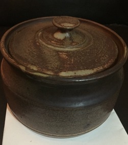
 Orbost & District Historical Society
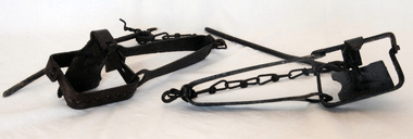
rabbit traps, First half 20th century
During the Great Depression from 1929 to 1932, rabbit trapping was a means of survival for many people. Rabbits provided meat and pelts which were sold for making felt hats such as the Akubra. Rabbit populations are controlled in the 21st century by poisoning, destroying or 'ripping' burrows (warrens), biological control with rabbit haemorrhagic disease and myxomatosis, and by shooting. Rabbit-proof fences also prevent the spread of rabbits into some areas. (ref. Powerhouse Museum) Steel-jawed rabbit traps were widely used in urban and rural Australia from 1880 to 1980. This trap is symbolic of the battle that Australians have waged against burgeoning rabbit populations for over a century. Rabbits cause enormous damage to Australian soils and biodiversity. The introduction of rabbits to this country was an environmental disaster.Two iron rabbit traps. Each consists of a pair of jaws held closed by spring tension and a triggering mechanism. When the trap is triggered the jaws close over the top of the bridge, plate and tongue mechanism that is designed to trigger the trap. A chain is attached by a hook on the bent end of the trap's spring with a long steel spike looped over the last link of the other end of the chain. The trap is designed so that the metal jaws snap shut against each other when the trap is activated by the application of weight to the pressure plate. In use, traps are set with open jaws, buried lightly just below the surface of the earth. When an animal steps on the pressure plate, the jagged teeth of the jaws snap around the animal's leg, usually breaking bone and sinew. Thus the animal is immobilised.rabbits rural trapping -
 Warrnambool and District Historical Society Inc.
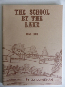
Booklet, The School by the Lake 1858-1983, 1983
This book gives information on the history of Terang Primary School which opened as a National School in 1858. It then became Terang Common School No. 617. It was destroyed by fire in 1871 and rebuilt, becoming, after 1872, Terang State School. Peter Carmichael was the Head Teacher from 1859 to 1884. The book was written to celebrate the 125th anniversary of the school’s foundation. The school is now part of a dual campus P-12 school known as Terang CollegeThis book is of some interest as a record of the Terang Primary School up to 1983. Terang is one of the towns in the Western District that has some connection to Warrnambool because of its relative closeness to the latter city. This is a soft cover book of 56 pages. It has a buff-coloured cover with a sketch of Terang Primary School in brown tonings. The sketch encompasses both the front and the back covers. The book has Acknowledgements, a Foreword, a list of Head Masters, printed information on Terang Primary School and a Bibliography. It contains black and white photographs, plans and sketches. The book is bound with metal staples.Front Cover: ‘The School by the Lake, 1858-1983, by J.H.Linehan.’terang primary school, history of terang, warrnambool history -
 Flagstaff Hill Maritime Museum and Village
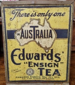
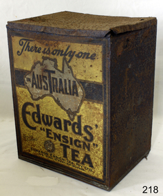
Container - Tin Tea Container, Wilson Bros, 1900-1940
The tin was made by Wilson Bros, Melbourne, for Edwards' Ensign Tea Pty Ltd, Melbourne, Victoria, Australia, 1900-1940. There was a fire at their factory in Flinders Street Melbourne on April 30, 1921 which completely destroyed the building. New premises were obtained at 310/18 King Street Melbourne in 1923. there continued to be bill board advertisements for Ensign tea at the King Street address, also regular adverts in the Argus newspaper during1942.An Australia icon during the first half of the 20th century as tea drinking was a popular past time and social activity.Container for tea with hinged lid. Label yellow with map of Australia. Lid is coming away on one hinge. "Edwards Ensign Tea" On label "Edwards Ensign Tea"flagstaff hill, warrnambool, shipwrecked coast, flagstaff hill maritime museum, maritime museum, shipwreck coast, flagstaff hill maritime village, great ocean road, tea tin, tea caddy, drink, container, wilson bros, ensign tea -
 Federation University Historical Collection
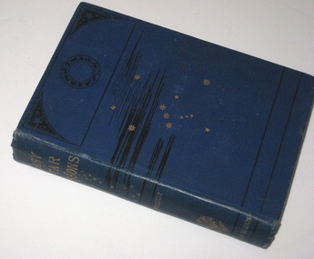
Book, Richard A. Proctor, Easy Star Lessons, 1881
In 1873 Teesdale residents formed an institute to provide literature to improve the minds. The site was gazetted on 25 October 1875 – a one acre site on the corner of Bridge Street and Mercer Terrace. A Mechanics Institute was built and later a supper hall was added in front of the institute. The mechanics institute and supper hall was destroyed by fire on the night of 29 March 1969. (http://linkingtowns.com/index.php?option=com_content&view=article&id=91&Itemid=252) Blue hard covered book of 239 pages. Many illustrations f constellations during each month. Inside front page 'Mechanics Institute Teesdale No 270'astronomy, library, teesdale, mechanics institute -
 Flagstaff Hill Maritime Museum and Village
Container - Tin Tea Container, Wilson Bros, 1900-1940
The tin was made by Wilson Bros, Melbourne, for Edwards' Ensign Tea Pty Ltd, Melbourne, Victoria, Australia, 1900-1940. There was a fire at their factory in Flinders Street Melbourne on April 30, 1921 which completely destroyed the building. New premises were obtained at 310/18 King Street Melbourne in 1923. there continued to be bill board advertisements for Ensign tea at the King Street address, also regular adverts in the Argus newspaper during1942.An Australia icon during the first half of the 20th century as tea drinking was a popular past time and social activity.Container for tea with hinged lid. Label yellow with map of Australia. Lid is coming away on one hinge. "Edwards Ensign Tea" On label "Edwards Ensign Tea"flagstaff hill, warrnambool, shipwrecked coast, flagstaff hill maritime museum, maritime museum, shipwreck coast, flagstaff hill maritime village, great ocean road, tea tin, tea caddy, drink, container, wilson bros, ensign tea -
 Ballarat Heritage Services
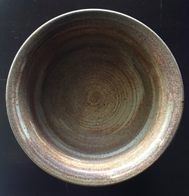
Ceramic - Wheel Thrown Stoneware Bowl
Belltower Pottery was established by Rudolf Dybka in Kyabram, Victoria, in around 1977 with the help of John Stroomer. Stroomer later took over the pottery, employing as many as 23 workers and apprentices. After a fire in 1988 destroyed the building, Stroomer moved the pottery to the old Kyabram butter factory, where it operated until the late 1990s. Works may be marked with an impressed 'Belltower Pottery' or, after the move to Kyabram, 'Belltower Pottery, Handmade, Kyabram, Vic.'Wheel thrown stoneware bowl with the word 'Nuts' on one side. Stamped "'Belltower Pottery, Handmade, Kyabram, Vic"pottery, belltower pottery, kyabram, australia studio pottery -
 Stawell Historical Society Inc
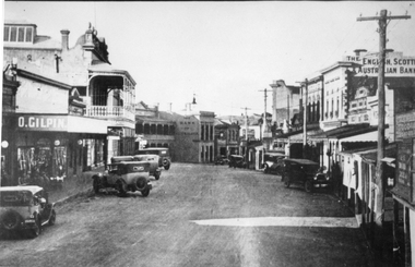
Photograph, Upper Main Street Stawell looking East 1930
Upper Main Street looking East c 1930. Two Story shop on left behind O. Gilpin is Chadwicks Draper later partially destroyed by fire. Some buildings not visible, Commercial Hotel then Oriental Bank / The Bank Australasia in Centre of Photo, Punchard's Furniture. On right of street, side of Mechanics institute, B.S. Dawson Chemists & R.H. Wadsworth Watchmaker, the English Scottish & Australian Bank on right. Clark & Scott Drapery. stawell streetscape -
 Wodonga & District Historical Society Inc
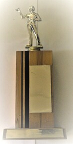
Award - Darts Trophy - A.W.D.D.A 1992 A Grade Premiers
The Terminus Hotel was one of the earliest hotels in Wodonga, with clear links to the establishment of the railway line. It was an important business and meeting place from the original construction in 1873 until 1st June 1998 the Terminus Hotel when it was destroyed by fire. It provided a popular venue for social activities, including competitive darts, both through its own competition and as part of the Albury-Wodonga District Darts Association. The remains of the building were demolished in 1999. The Terminus Hotel was an important meeting place in Wodonga for more than 100 years. This item is representative of one of the social and sporting activities it provided for members of the local community.A wood and metal trophy with a figurine of a darts player mounted on the top and a metal panel engraved with players' names.At base of trophy: "A.W.D.D.A 1992 / A GRADE PREMIERS / TERMINUS ALBURY" On front of trophy, top to bottom " J. DEKRUIFF (C) B. TINGWELL S. HONG L. SIMS S. GRIFFITHS A. GARDNER R. GARDNER'terminus hotel wodonga, terminus hotel darts, sport and recreation wodonga -
 Kew Historical Society Inc
Photograph - Demolishing the Zig-Zag Bridge, 1929
Henry Beater Christian (1886-1962) , was a descendant of one of the earliest settler families in Kew. Employed at the Kew Asylum as a 'public servant', he was a skilled amateur photographer, photographing numerous scenes in Kew and on his travels around Victoria. The majority of his photographs date from 1916 to 1929. His finest photographs are housed in two photograph albums. Rare photograph of the demolition of the Zig-Zag Bridge linking the two asylums on either side of the Yarra River.Digital copy of a photograph from page 16 of the 47-page photograph album containing 261 gelatinous silver images, loaned by Diane Washfold with permission given to digitise and hold a copy in our collection. The Zig-Zag Bridge linked the grounds of the Yarra Bend and Kew Asylums. The wooden bridge was constructed in the 1870s and lasted through numerous floods until its destruction in 1929. A horizontal structure, the walkway was reached via a wooden staircase on the Kew bank of the river. The steps were required due to the different levels of the banks on this stretch of the river. This is a photo of the bridge before part of it was destroyed in a flood in 1929. A man, perhaps Henry Christian, stands at the right of the foreground."Demolishing Zig-Zag / 6. 1929"henry beater christian (1886-1962), landscape photography, kew (vic.) — yarra river, christian-washfold collection, photograph albums, zig-zag bridge -
 Bendigo Historical Society Inc.
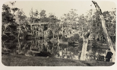
Document - THE LAZARUS MINE - LAZARUS COY'S OLD ENGINE-HOUSE DESTROYED
Handwritten and typed copy of a report in the Bendigo Advertiser Mon 11/1/1892 of a fire which totally destroyed the engine-house at Lazarus Coy's mine at New Chum on Sunday 10th January at 2 a. m. Last page has a copy of a letter to the Editor of the Advertiser from William Nolan, Captain, G. S. V. F. B. contradicting Superintendent Daymond's statement that said the City Brigade had first water on the fire and the Golden Square was next. William Nolan says they had water on the fire ten minutes before the City Brigade arrived. He was hoping the Superintendent would rectify his mistake. Notes prepared by Albert Richardson.document, gold, the lazarus mine, the lazarus mine, lazarus coy's old engine-house destroyed, bendigo advertiser mon 11/1/1892, mr henry james, old chum hill, geo lansell, city brigade, temperance brigade, mr whitford, superintendant daymond, golden square brigade, william nolan, g s v f b -
 Eltham District Historical Society Inc
Photograph, Willis Vale on the north bank of the Plenty River, Church Street, Greensborough, c.1950
Photo sourced from Heidelberg Historical Society reproduced on p63 of The Diamond Valley Story by Dianne H. Edwards, Shire of Diamond Valley 1979. "Willis Vale, Greensborough, situated on the north bank of the Plenty River at the end of Church Street. The home wasa built about 1840 by Jame Willis Mayger from bricks hand-made nearby. It was later passed to the Partington family and when this photo was taken the building was deserted. Vandals and finally a bushfire destroyed Willis Vale in the 1950s." Greensborough Historical Society has same image with more accurate information on the date/cause of fire damage https://victoriancollections.net.au/items/585b6c96d0ce2c1268f1c96b "House built by Edward Maygar, Robert Whatmough lived there mid 19th century and later sold to Partington family. It was located on the Plenty River at Partington's Flat Greensborough. The derelict Willis Vale house was destroyed in 1964 when a fire originating from North Plenty Gorge - Kurrak Road - was lit by two teenage boys and made its way several kilometres down to Partington's Flat Greensborough."Black and white copy of photo printed on glossy photographic paper 30.5 x 40.5 cm (12 x 16 inch); image size approx. 18.5 x 28 cmchurch street, diamond valley story, greensborough, james willis mayger, partington family, willis vale -
 Wodonga & District Historical Society Inc
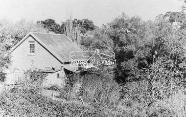
Functional object - Jurors' Selection Barrel, Wodonga Court House
The barrel was used in the Wodonga Court House as part of the selection process for jurors. It was a standard issue barrel used throughout Victoria. It was retrieved from the ruins of the court house which was destroyed by fire. It was then donated to the Wodonga Historical Society. The timber display stand was made and donated by Jake Tooley, a Wodonga Historical Society member, The Court House was situated in the Customs Store building alongside the Wodonga Police Station in 93 High Street. (The house where the Police Station was had originally been the home of the Customs Officer). In early 1964, the court house building was burnt beyond repair and furniture and other property destroyed. The cause of the fire was never found. The Police Station was lucky to survive but only because of the efforts of the local Fire Brigade. After the fire, the court was held first at the old Fire Station premises near where the Wodonga Post Office is near Woodland Grove, then it moved to a vacant building in Mitchell Street which was later turned into a Child Care Centre. Foundations for the new court house in Elgin Street were laid in October 1965 Local significance due to its use in the Wodonga Court House and its survival of a major fire. State significance as it documents a procedure used in the Victorian Court and Legal system Cylindrical metal-iron barrel painted black with writing stenciled on the front in white The timber mount was made for storage and display is not part of the original object,Inscription on Barrel "WODONGA./ Jurors in use./ Special"wodonga court, jurors, selection, legal system, fire -
 Warrnambool and District Historical Society Inc.
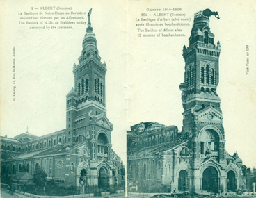
Postcard - Basilica Notre Dame Albert France, 1914-1918
This is number 20 of 27 items in the Daisy Vickers collection of World War One memorabilia. These items were sent or given to Daisy Ogier (nee Vickers) during World War One by Corporal Arthur Anderson who enlisted from Warrnambool in 1915 at the age of 21. He served in Egypt and France and returned to Australia in 1919. Daisy Ogier (1907-1987) was a student and then a teacher at Warrnambool Technical School with her early teaching years there from 1925 to 1936 and in 1949. She became the head mistress from 1950 to 1963 and in 1968. She officially retired in 1976. Daisy Vickers was one of the best loved and dedicated teachers that the school ever had. She married the Reverend Fred Ogier and continued her association with the school after her husband's death.This card is interesting because of its association with World War One and two local people Daisy Vickers and Arthur Anderson This is a piece of paper folded in two to make four pages. Two pages have printed lettering and handwriting . Two pages have black and white photographs of the basilica in Albert, France. 1 - ALBERT (Somme) La Basilique de Notre Dame de Brebieres aujourd' hui detruite par les Allemands . The Basilica of N.D. de Brebieres today destroyed by the Germans. Dear Daisy Just to let you know I received the scarf you sent. It came in very useful during the cold weather especially when there were plenty of snow and ice around. Arthur Miss Daisy Vickers, Bushfield Post Office Victoriadaisy vickers, arthur anderson, world war one postcard, world war one correspondence -
 Lara RSL Sub Branch
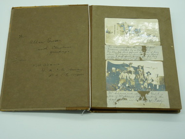
Photograph Album, To Allan Groves, 1917
Cardboard Album Khaki coloured 8 leaves with photos and written descriptionsFront sleeve To Allan Groves With Christmas greetings from Will Adams YMCA Secretary with A.L.H. Brigade There are explanations under each couple of photos too much to write in this space. In general the photos are of Will Adams experience in Egypt The Rafa Raid Prisoners of war, Beni Selah women waiting for water. Women making bricks, 53rd Casualty Clearing Station destroyed by a bomb, Royal Scots Fusilier Pipe Band after church parade, The Sultan Hasser Mosque photograph, album, egyp, ww1, allan groves, will adams, rafa raid, 53rd casualty clearing station -
 Orbost & District Historical Society
black and white photograph, 1934
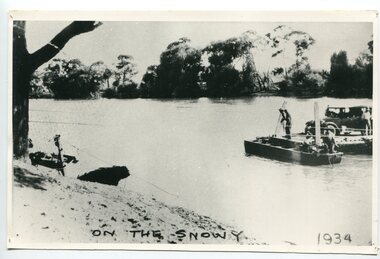
This photograph shows vehicles and people being ferried across the Snowy River during the 1934 flood. The Orbost punt was reinstated on a temporary basis following damage to the bridge. Damage estimated at £500,000 was caused by the 1934 floods in the Orbost district. This 1934 flood was devastating, destroying a section of the 1922 Orbost bridge, wrecking fences, bridges and roads, dumping silt and debris on the rich river flats and drowning cattle. The centre span of the Orbost Bridge was washed away.This is a pictorial record of the effects of the 1934 floods in the Orbost district.A large black / white photograph of a punt with a motor vehicle and people making their way across a river.on front - "On the Snowy 1934"snowy-river-orbost flood-1934 river-transport-punt -
 Lara RSL Sub Branch
FA/-18 Hornet Jet Fighter
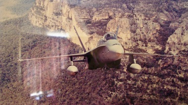
The Royal Australian Air Force (RAAF) has operated McDonnell Douglas F/A-18 Hornet fighter aircraft since 1984. The Australian Government purchased 75 "A" and "B" variants of the F/A-18 in 1981 to replace the RAAF's Dassault Mirage III fighters. The Hornets entered service with the RAAF between 1984 and 1990, and 71 remain in operation as of 2017. The other four Hornets were destroyed in flying accidents during the late 1980s and early 1990s.F/A-18 Hornet Jet Fighter replaced the Mirage Jet Fighter. Still in service in 2018.Framed PictureNILf/a-18 hornet jet fighter raaf -
![Sketch - Digital image, William Poulter's Bonnie Vale [sketch], 1925c](/media/collectors/4f729f5697f83e03086015b8/items/54d0485a2162f10e70db9490/item-media/54d0489e2162f10e70db9ed3/item-fit-380x285.jpg) Greensborough Historical Society
Greensborough Historical SocietySketch - Digital image, William Poulter's Bonnie Vale [sketch], 1925c
Copy of sketch of William Poulter's property "Bonnie Vale". William Poulter and his wife Mary arrived in Victoria in 1849 and settled in Greensborough in 1853, constructing "Bonnie Vale" soon after their arrival. The old house was completely destroyed by fire circa 1960. Bonnie Vale, if existent in modern times would have been found in south eastern centre of Poulter Reserve, over the Plenty River is the house property known as 'Blackjack' on 59 Hume Street.Greensborough pioneer family Digital copy of black and white sketch. -
![Photograph - Digital image, Willis Vale [house from distance], 1932c](/media/collectors/4f729f5697f83e03086015b8/items/54fd54082162f10d30c05b8a/item-media/54fd54392162f10d30c05f8f/item-fit-380x285.jpg) Greensborough Historical Society
Greensborough Historical SocietyPhotograph - Digital image, Willis Vale [house from distance], 1932c
Willis Vale: House built by Edward Maygar, Robert Whatmough lived there mid 19th century and later sold to Partington family. It was located on the Plenty River at Partington's Flat Greensborough. Land use included farming and orchards. The derelict Willis Vale house was destroyed in 1964 when a fire originating from North Plenty Gorge - Kurrak Road - was lit by two teenage boys and made its way several kilometres down to Partington's Flat Greensborough.Home of the Partington familyDigital copy of black and white photograph.willis vale, partington family, whatmough, maygar -
 Greensborough Historical Society
Photograph - Digital Image, Willis Vale, 1920c
Willis Vale: House built by Edward Maygar, Robert Whatmough lived there mid 19th century and later sold to Partington family. It was located on the Plenty River at Partington's Flat Greensborough. Land use included farming and orchards. The derelict Willis Vale house was destroyed in 1964 when a fire originating from North Plenty Gorge - Kurrak Road - was lit by two teenage boys and made its way several kilometres down to Partington's Flat Greensborough.Home of the Partington familyDigital copy of black and white photograph.willis vale, partington family, maygar, whatmough -
 Greensborough Historical Society
Photograph - Digital image, Willis Vale in Colour, 1940c
Willis Vale: House built by Edward Maygar, Robert Whatmough lived there mid 19th century and later sold to Partington family. It was located on the Plenty River at Partington's Flat Greensborough. Land use included farming and orchards. The derelict Willis Vale house was destroyed in 1964 when a fire originating from North Plenty Gorge - Kurrak Road - was lit by two teenage boys and made its way several kilometres down to Partington's Flat Greensborough.Home of the Partington familyDigital copy of colour photograph.willis vale, partington, whatmough, maygar -
![Photograph - Digital image, Willis Vale [front door], 1900c](/media/collectors/4f729f5697f83e03086015b8/items/55029fb42162f11024c2fdd5/item-media/55029fe62162f11024c300cd/item-fit-380x285.jpg) Greensborough Historical Society
Greensborough Historical SocietyPhotograph - Digital image, Willis Vale [front door], 1900c
Willis Vale: House built by Edward Maygar, Robert Whatmough lived there mid 19th century and later sold to Partington family. It was located on the Plenty River at Partington's Flat Greensborough. Land use included farming and orchards. The derelict Willis Vale house was destroyed in 1964 when a fire originating from North Plenty Gorge - Kurrak Road - was lit by two teenage boys and made its way several kilometres down to Partington's Flat Greensborough.Home of the Partington familyDigital copy of black and white photograph.willis vale, partington -
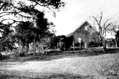
 Eltham District Historical Society Inc
Photograph, Evelyn Hotel, Eltham, c.1911
Postcard image of W. Morris Evelyn Hotel, cnr. Main Road and Pitt Street, Eltham, opposite present hotel. This image is post the 1910 fire which damaged the southern two-storey section. It was rebuilt as single story. The hotel was delicensed in 1919 and became a Dining Room then a boarding house. It was destroyed by fire in the summer of 1931 when at the time it was occupied solely by the McLean family, Hector and Louisa McLean who had five young daughters at the time.Postcard photoRetun to Garnet Burges c/o Judge Bookhotels, evelyn hotel, eltham, main road, pitt street, fountain hotel, william morris -
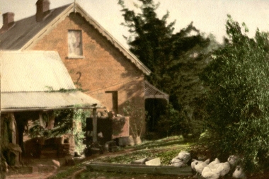
 Eltham District Historical Society Inc
Photograph, Fountain Hotel, Main Road, Eltham
Digitised from scanned print of original postcard of Fountain Hotel, Main Road Eltham (later Evelyn Hotel) early view showing two storey section. Built in 1852 as the Fountain of Friendship Hotel, later named the Fountain Hotel in the 1880s. Located on the southwest corner of Maria (Main) and Pitt streets. Later known as the Evelyn or Evelyn Arms Hotel, it was de-licensed in 1919. The hotel was totally destroyed by fire on Wednesday, February 18, 1931Digital file scan of photo print copy and photocopy of original image of Fountain Hotel, Main Road Eltham (later Evelyn Hotel) early view showing two storey sectionhotels, eltham, fountain hotel, evelyn hotel, main road, pitt street -
 Ballarat Heritage Services
Ceramic - Image, Belltower Pottery, Lidded Wheel Thrown Bowl, c1995
Belltower Pottery was set up by Rudolf Dybka in Kyabram, Victoria, in around 1977 with the help of John Stroomer. Stroomer later took over the pottery, employing as many as 23 workers and apprentices. After a fire in 1988 destroyed the building, Stroomer moved the pottery to the old Kyabram butter factory, where it operated until the late 1990s. Works may be marked with an impressed 'Belltower Pottery' or, after the move to Kyabram, 'Belltower Pottery, Handmade, Kyabram, Vic.'Wheel thrown stoneware bowl with the word 'Nuts' on one side. pottery, belltower pottery, rudolf dybka, john stroomer -
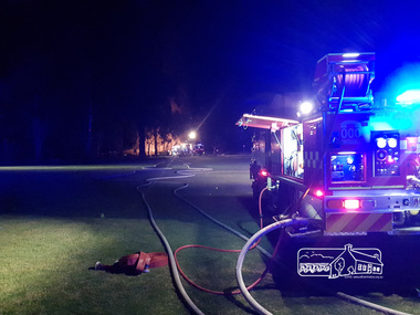 Eltham District Historical Society Inc
Photograph, Anthony Owen, Arson fire in early hours of the morning destroys the Adventure Playground at Eltham North, 16 December 2017
A community group project steered by Bambi McLean led to the construction of the Eltham North Adventure Playground which opened off Wattletree Road in 1995. The structure was mainly wooden and included an undercover element with slides and areas to climb. It was destroyed by fire in the early hours of 16 December 2017. These phtoos were taken at approx. 2am on the morning of 16 December 2017 by 2nd Lieutenant Anthony Owen of Eltham Fire Station. A new adventure playground was built in 2018.Digital fileeltham north, north eltham adventure playground, arson, wattletree road, fire engine, eltham fire brigade, eltham fire station, eltham cfa -
 National Vietnam Veterans Museum (NVVM)
Poster - Poster, Information Board, 5 RAR 1966 - 1967 (1st Tour)
An Poster, Information Board of 5 RAR 1966 to 1967 (tst Tour). The 5th Battalion Royal Australian Regiment ("Battalion") were the leading element of the First Australian Task Force (1 ATF) and stationed in Vietnam from 1966 to 1967. The Battalion's task was to break Viet Cong control over the central region of Phuoc Tuy Province - an area that communists had freely operated in since 1945. Commencing of the 24th May 1966, the Battalion conducted its first operation codenamed "Hardihood". Their objective was to sweep and clear areas to the north and east of Nui Dat to a distance of 5000 meters, then create a defensive position to enable 1 ATF to establish an operation base. The Battalion conducted eighteen full-lenght operations as well as numerous day and night cordon and search, search and destroy, ambush and clearing patrols conducted at company, platoon and section levels. the Battalion achieved considerable success during Operations Canberra and Queanbeyan in October 1966 when it swept and cleared the Nui Thi Vai mountain. A Viet Cong base consisting of training facilities, a hospital, booby trap factory and several tonnes of rice was located and destroyed. during phase two (Operation Queanbeyan) the battalion discovered complex cave and tunnel systems along with other fixed installations that were vigorously fought for and destroyed by the battalion. Not only di the caves contain large quantities of weapons, equipment and documents but the 274 VC Regiments deputy commanders radio complex. For bravery and leadership, three Military Crosses, one Military Medal and one Mentioned in Dispatches were awarded. The last was awarded posthumously. However, at the completion of the battalion's first tour, the 274 and 275 Viet Cong Regiments remained functional. While the enemy retained the capacity to inflict serious casualities on smaller allied forces, the Battalion and other elements of the 1 AFt were successful in denying the enemy their previous gains. This enabled the South Vietnamese Government to re-establish control of over 96 per cent of the Phuoc Tuy Province during Australia's involvement. Source O'Neill, RJ Vietnam Task, the 5th Battalion, Royal Australian Regiment 1966/67, Melbourne. Cassell Australia Ltd, 19685 rar, 1st tour 1966 - 1967, operation hardihood, 1st atf base, poster, information board, nui dat, nui thai vai mountains, operation canberra, operation queanbeyan, viet cong, 274 vc regiments -
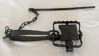 Orbost & District Historical Society
rabbit trap, first half 20th century
During the Great Depression from 1929 to 1932, rabbit trapping was a means of survival for many people. Rabbits provided meat and pelts which were sold for making felt hats such as the Akubra. Rabbit populations are controlled in the 21st century by poisoning, destroying or 'ripping' burrows (warrens), biological control with rabbit haemorrhagic disease and myxomatosis, and by shooting. Rabbit-proof fences also prevent the spread of rabbits into some areas. (ref. Powerhouse Museum) This trap was used in the Orbost district. Steel-jawed rabbit traps were widely used in urban and rural Australia from 1880 to 1980. This trap is symbolic of the battle that Australians have waged against burgeoning rabbit populations for over a century. Rabbits cause enormous damage to Australian soils and biodiversity. The introduction of rabbits to this country was an environmental disaster.A rusted iron rabbit trap which consists of a pair of jaws held closed by spring tension and a triggering mechanism. When the trap is triggered the jaws close over the top of the bridge, plate and tongue mechanism that is designed to trigger the trap. A chain is attached by a hook on the bent end of the trap's spring with a long steel spike looped over the last link of the other end of the chain. The trap is designed so that the metal jaws snap shut against each other when the trap is activated by the application of weight to the pressure plate. In use, traps are set with open jaws, buried lightly just below the surface of the earth. When an animal steps on the pressure plate, the jagged teeth of the jaws snap around the animal's leg, usually breaking bone and sinew. Thus the animal is immobilised. rabbit-trap rural -
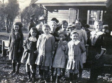 Kiewa Valley Historical Society
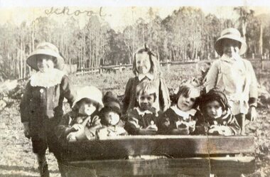
Photo - School Children Tawonga Primary School, Circa 1920 (estimate)
Tawonga is in the Kiewa Valley, where local farmers lived with their families. The school was originally opened July 27 1880, situated on 8 acres near the current township of Tawonga. The school was erased by fire in 1900 and all records destroyed. The school was then moved to the Old Tawonga Hall. In 1910, the school was shifted to its present site on 3 acres of land donated by Frank Cooper. The school building and attendance continued to grow, especially during construction of the Kiewa Hydro Electric Scheme.Tawonga Primary School has educated the local farming and town children for many years. It is an excellent source of the names of the local families of the time ie: Vera Ryder – front row, far right (little girl with the wide headband.)Copy of black and white photograph of pupils at Tawonga Primary School. Circa 1920 (estimate)tawonga primary school, kiewa valley -
 Kiewa Valley Historical Society
Photo - School Children Tawonga Primary School, Circa 1920 (estimate)
Tawonga is in the Kiewa Valley, where local farmers lived with their families. The school was originally opened July 27 1880, situated on 8 acres near the current township of Tawonga. The school was erased by fire in 1900 and all records destroyed. The school was then moved to the Old Tawonga Hall. In 1910, the school was shifted to its present site on 3 acres of land donated by Frank Cooper. The school building and attendance continued to grow, especially during construction of the Kiewa Hydro Electric Scheme.Tawonga Primary School has educated the local farming and town children for many years. It is an excellent source of the names of the local families of the time. Copy of black and white photograph of pupils at Tawonga Primary School. Circa 1920 (estimate)tawonga primary school, kiewa valley -
 Kiewa Valley Historical Society
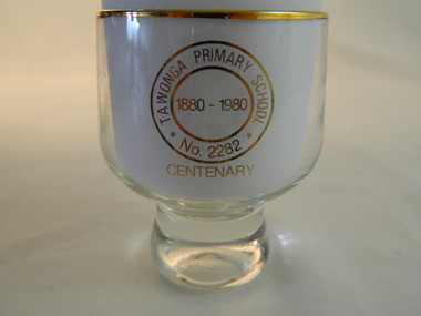
Trophies - Glass - Tawonga Primary School, 1980
The Tawonga Primary School was a weatherboard building built on 8 acres. In 1900 a fire destroyed the building and its records. The school was then moved to the Old Tawonga Hall before a new one was built in 1910 on land donated by Frank Cooper. In 1937 and 1954 further buildings were added. Tobacco farming and the building of the Kiewa Hydro Electric Scheme increased the number of pupils during the 1950s and 1960s. This glass represents the celebration held when the school became 100 years old.Tawonga Primary School was established for the children of the farmers of the Kiewa Valley in 1880 and later for children of the tobacco farmers and workers on the Kiewa Hydro Electric Scheme. The history of the school reflects the activities of the people living in the valley and in particular Tawonga township.Clear glass with gold metal brim and embossed in gold on two sides. Base is solid tapering up to the glass sides.On one side: Gold embossed picture of school building On opposite side: Gold embossed 2 circles - Inside inner one: 1880 - 1980. Between this and outer circle - Tawonga Primary School No 2282. Underneath both circles gold embossed: Centenarytawonga primary school, kiewa valley, education