Showing 1588 items
matching farming.
-
 National Wool Museum
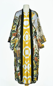
Textile - Cloak, Dr Deanne Gilson, Banksia Tree Cloak (water and fire business), 2022
Standing proud, still here, the spirit of ten ancestral matriarchs adorned in contemporary ceremonial cloaks. Representing our women past, present and future, her Spirit, our culture, our Country (spelt with a capital for its importance and this is part of First Peoples protocols on acknowledging Country, our strength, our resilience and healing towards a sustainable future).The sacred banksia tree was a favourite for Wadawurrung people. Flowering before deep Winter, the banksia was used for spear making and other wooden tools. The sap was drunk as a sweet drink and the seed pods used for water straining and fire sticks. The banksia tree flowers at the time when fire sticks farming is practiced marking the days before the coldest days and nights and the hotter days.White, orange, and yellow banksia design on outer cloak, yellow and white circle and diamond design in lining. Solid black trimming. Cloak is machine sewn and handstitched with hand stitching on shoulder seam.deanne gilson, wadawurrung dja, first nations art, cloak -
 Warrnambool and District Historical Society Inc.
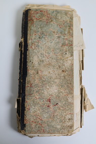
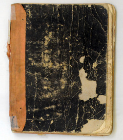
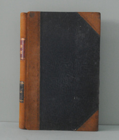
Document - Ledger 1883-1892 repurposed
This ledger was used between 1883 and 1892 to record returns and activities on a farming property including numbers of sheep shorn, chaff cut, fencing contracted and people employed. One envelope within the ledger is addressed to Mrs J Edwards, Morven via Branxholme. The Edwards family, lived on the MORVEN property situated about 11 kilometres west of Branxholme in the Western District of Victoria. This property was sub divided in 1911 into 25 farms. The not fully used ledger has later been repurposed as a recipe book with a collection of newspaper cuttings (1924-1929) inserted and recipes handwritten on 16 pages at the rear. The pages also include some household hints including instructions on how "To prepare sheep skins for mats"This ledger is typical of farming records kept in the period 1883 to 1892. The repurposing of the ledger as a recipe book was a common practice. This ledger has cardboard patterned covers. The paper pages are bound with cotton. Some pages are handwritten in ink. There are loose newspaper cuttings within the ledger as well as two addressed envelopes and a small red recipe booklet.ledger, farming records, recipes, morven, edwards family morven, canvassing department of the australian dried fruits association -
 Linton and District Historical Society Inc
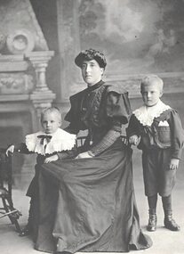
Photograph, Harriet Knight with Sons George and William
A daughter of Henry Francis and his wife Mary (née Hepbuirn or Hepburn), Harriet married George Knight of Spring Vale (now Pittong) in 1900. Harriet is shown in this photograph with her two sons - William, born 1903, and George, born 1905. Harriet and George Knight also had a daughter, Victoria May, born 1901, who died in 1904. Harriet's husband George died in 1907. After she was widowed Harriet continued to run their farming enterprise. As part of this she ran a butchery, providing meat to people living in the Pittong district. Alice Knight (Harriet's granddaughter) commented in 2018 that the photo shows Harriet having quite muscular arms, which she thought was a result of hard physical labour on the farm.Black and white portrait of a woman wearing a dark dress with high collar, sitting in a chair with a small boy on either side, both boys wearing large white lace collars. Harriet Knight (Mrs. George Knight) with sons George and William.harriet knight (née francis), george knight, william (bill) knight -
 The Beechworth Burke Museum
Audio - Oral History, Jennifer Williams, John Watson, 22 June 2000
John Watson's story shows insight to the families that moved to Beechworth and the motivation behind this. It showcases the nuances of life in the district and the day to day ways of living. This history speaks of land cultivation and the innovation of industry in the region, in particular cattle farming and butchering. Watson's account speaks of the way that the practice of breeding cattle effects the rural lifestyle, and the hardships that come with working on the land. This oral history recording was part of a project conducted by Jennifer Williams in the year 2000 to capture the everyday life and struggles in Beechworth during the twentieth century. This project involved recording seventy oral histories on cassette tapes of local Beechworth residents which were then published in a book titled: Listen to what they say: voices of twentieth century Beechworth. These cassette tapes were digitised in July 2021 with funds made available by the Friends of the Burke.Watson's account is historically significant due to its ability to illustrate the lifestyle and industry of those in Beechworth during the twentieth century. It is a rare insight into the the practices of residents of this time. This oral history also shows deep insight into the social structure of the community. It describes the family and community dynamics over a long period of time, the motivations behind behaviour, and the greater community fabric. This is a digital copy of a recording that was originally captured on a cassette tape. The cassette tape is black with a horizontal white strip and is currently stored in a clear flat plastic rectangular container. It holds up 40 minutes of recordings on each side.John Watson1800s beechworth, 20th century beechworth, beechworth, farming and agriculture, farm, farm work, farmers, farming, cattle, industry, oral history, john watson -
 Orbost & District Historical Society
book, 1922-1929
This item has been identified by David Nixon as the workbook of George Henry Douglas Russell (Doug) of Bete Bolong. He was the second son of John and Elizabeth Russell. John Russell wasblacksmith in Orbost. His family were Jack, Doug, Dave and Billy. Doug was in WW! where he was a Veterinary Sergeant. After the war he came bach to Orbost and his father gave him the farm at Bete Bolong to work. This farm is on the corner of Birkins Lane and Buchan Road (presently owned By Ginger and Helen Johnstone). He started farming tgere in 1920 and married Hilda Raymond in 1922. The slatted barn and house still exist. David Nixon, the donor, married a daughter of Doug and Hilda Russell and worked the farm from 1947-1973. He found the diary at the farm. This item is a valuable record of agricultural practices in the Orbost district during the 1920's.An exercise book with a worn black cover and a faded red spine. It contains hand-written records of farm accounts. russell- bete-bolong diary-farming agriculture -
 Warrnambool and District Historical Society Inc.
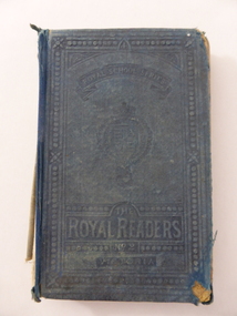
Book, The Royal Readers, Late 19th century
This book is one of the series of Royal Readers (Scotland) introduced into schools in Victoria in 1877 to replace the Irish Readers. They were in use until the 1920s and at first contained mostly British material (as does this copy which has no Australian content and features many articles on animals). By the late 19th century the Royal Readers used in Victoria contained some Australian material and it is presumed that this copy is an early edition. The Bonnett families were associated with farming in the Mepunga area and Jessie Edith Bonnett, the daughter of Frederick Bonnett and Charity Bonnett (nee Phillips) was born in Allansford in 1897. Jessie Bonnett spent her life on the family farm at Mepunga and was the last of the Bonnett families in that area. Mepunga East State School was established in 1886 with Ruth Broadway as the first Head Teacher. It has now closed. This book, though tattered, is of interest as an example of the Royal Readers used by pupils in Victorian schools in the late 19th and early 20th centuries. It is also important as a book belonging to Jessie Bonnett, a member of the Bonnett family of farmers in the Mepunga area. The Warrnambool and District Historical Society holds in its collection some other items that belonged to Jessie Bonnett, including an important World War One scrapbookThis is a hard cover book of 186 pages. The cover was originally a dark blue-green colour but it is much faded and is now almost detached from the binding. The spine and several pages at the beginning and the end are missing. The text contains many black and white illustrations and some have been coloured in. Some of the pages are torn and stained. There is much scribble on the front and back covers. The inscriptions are handwritten in black ink.‘Jessie Edith Bonnett, Mepunga East State School No. 2762’ jessie bonnett, mepunga east state school -
 Warrnambool and District Historical Society Inc.
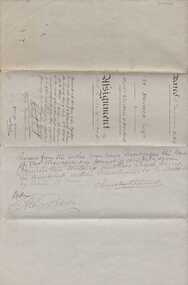
Document, Indenture A Bostock Esquire to Messrs Aitkin & Bostock( Ernest), 1865
The Bostock, Manifold and Aitkin families were all pioneering families in the Western District of Victoria almost from the time of settlement. They leased and owned vast tracts of land and operated businesses around the district, often associated with the farming industry. This document is dated 5th July 1865 and is an assignment of stock by way of mortgage. Augustus Bostock is the mortgagor with James William Manifold Aitkin and Ernest Bostock as mortgagees. At various times they were involved in running businesses together, in particular the Aitkin and Bostock store and flour mill. Three of the Bostock men were married to three of the Aitkin sisters. The amount in question is £2157/3/2 and surety is 8000 sheep and their increase, presently running at Coomete. The penciled in details on the document refer to Robert Brand Paterson who was later in business with Aitkin This is one of a number of documents which relate to the Bostock family who were one of the most important pioneering families of the Western District. They owned and leased various properties around Warrnambool and were involved in many aspects of social and business life. The document itself is indicative of its time and provides an insight into the details and terms of such documents at the time.Large grey coloured, lined hand written document over four pages. Folded in four with date and details on one section. Red wax seal on page 3. There are extra entries written in black lead pencil in areas relating to the money and surety of the agreement.Signed by the following George Barber Warrnambool, Thomas Sunderland Deputy Registrar General, and Augustus Bostock. Hingston & Co, Chancery Lane Melbourne hand written in top left hand corner. warrnambool, bostock,augustus bostock james william manifold aitkin,robert brand paterson, coomete, -
 Warrnambool and District Historical Society Inc.
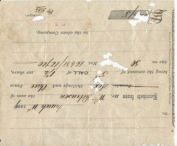
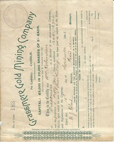
Document, Receipt March 11 1899, 1898
Grassmere is a small hamlet about 12 kilometres from Warrnambool. It is a farming area. The Grassmere Gold Mining Company, presumably established by local people in Grassmere, was created in 1898 for the purpose of acquiring from Messrs James and Mewha a lease of a Cassilis gold mine (23 acres). £5000 was to be raised in shares of five shillings and one shilling each. The Manager of the Company was Horatio Dickson of Melbourne and the brokers were McMeekin and Co. of Melbourne and Warrnambool and Dickson and Osborne of Melbourne. This reef mine was one of several in Cassilis, Gippsland, 12 kilometres north west of Swifts Creek. The gold-bearing quartz reefs were discovered in 1885 and worked to 1914. It is not known whether the Grassmere Cassilis mine was a financial success but the mining operations were impeded by the hardness of the stone in the area. William Robinson was a farmer in the Grasmere district. This receipt is of considerable interest as one of only three items the Warrnambool and District Historical Society has that is connected to the Grassmere Gold Mining Company. The gold mine establishment was one of the minor events in the district in the 1890s. This is a buff-coloured 1899 receipt for William Robinson who has paid six shillings and threepence for part payment of his shares in the Grassmere Gold Mining Company. The receipt has black printing and black-ink handwriting. There is one stamp of the Manager ‘H.S. Dickson’ and another of ‘Grassmere Gold Mining Company No Liability’. The receipt has several holes caused by silver fish damage. ‘March 11th 1899, Received from Mr Wm. Robinson the sum of six shillings and threepence being the amount of 3rd call of 1½ per share due on 50 shares nos. 12651/12700 in the above Company, H.S.Dickson, Manager’ grassmere, grassmere gold mining company, william robinson -
 Uniting Church Archives - Synod of Victoria
Photograph, Barry Baker - exit appointment, 1985
The class of '84 – Happily Settled. "Barry Baker has been mixing wheat farming with theological studies for several years. And now from his Rupanyup farm he's moving to Cavendish. He's 48, married with three children. His wife, Helen, married a farmer, and is working through her new role as a minister's wife. Barry is looking forward to going back to the country. He found the five years of study, the first three as a private student, a pretty long drag, although he's immensely enjoyed the privilege of theological study. He considers the ministry will be very much a pastoral one. "I've go to know my people before I can preach to them," he told me. He's interested in cricket and music."B & W head & shoulders photo of Rev. Barry Baker, wearing a skivvy and jumper.C&N identification.baker, barry, theological hall graduates 1984 -
 Kew Historical Society Inc
Photograph - Yarra Valley Floods: Kew East, 1916
Flooding of the Yarra Valley, including that section of the Yarra bordering Kew and Kew East in the north and west of the municipality, was a regular occurrence. Extreme flood events of the Yarra River are recorded to have occurred in 1891, 1901, 1916, 1923 and 1934. The Municipality of Kew's response to these floods was to enact planning decisions restricting residential development in flood prone areas following the floods of 1916, 1921 and 1934. While floods continued after the development of the Upper Yarra Reservoir (construction 1948-57), the regularity and extent of these inundations diminished. During the nineteenth century, the land abutting the south side of the Yarra in Kew was devoted to dairy farming. In the twentieth century, before and after the construction of the Eastern Freeway, much of this low-lying area was used as golf courses and public parks.One of a collection of photographs of flooding in the Kew section of the Yarra Valley which are in important research resource for the location and extent of flooding in the first half of the twentieth century. Flooding of the Yarra Valley at East Kew in 1916. The view is taken from the intersection of Kilby Road with what is believed to be Birdwood Street, looking across the flood waters to Ivanhoe. The extensive flooded area shown in the photograph would have included the Kew Golf Club. Verso: "Floods along Kilby Road / near Birdwood St? & Kilby Road / 1917? / 87yarra river, yarra valley, floods -- kew, kilby road -- kew (vic.), kew golf club -
 Kew Historical Society Inc
Photograph - Yarra Valley Floods: Kew East, 1916
Flooding of the Yarra Valley, including that section of the Yarra bordering Kew and Kew East in the north and west of the municipality, was a regular occurrence. Extreme flood events of the Yarra River are recorded to have occurred in 1891, 1901, 1916, 1923 and 1934. The Municipality of Kew's response to these floods was to enact planning decisions restricting residential development in flood prone areas following the floods of 1916, 1921 and 1934. While floods continued after the development of the Upper Yarra Reservoir (construction 1948-57), the regularity and extent of these inundations diminished. During the nineteenth century, the land abutting the south side of the Yarra in Kew was devoted to dairy farming. In the twentieth century, before and after the construction of the Eastern Freeway, much of this low-lying area was used as golf courses and public parks.One of a collection of photographs of flooding in the Kew section of the Yarra Valley which are in important research resource for the location and extent of flooding in the first half of the twentieth century. Flooding of the Yarra Valley at East Kew in 1916. The view is taken from a street (maybe Birdwood Avenue) intersecting with Kilby Road looking northeast across the flood waters to Ivanhoe and Heidelberg. The extensive flooded area shown in the photograph would have included remnant dairy farms and the Kew Golf Club. Verso: "Floods / Yarra River / East Kew / Kilby Road / 1917? / 87"yarra river, yarra valley, floods -- kew, kilby road -- kew (vic.), kew golf club -
 Kew Historical Society Inc
Photograph - Flooding of the Yarra Valley at Kew East, 1974
Flooding of the Yarra Valley, including that section of the Yarra bordering Kew and Kew East in the north and west of the municipality, was a regular occurrence. Extreme flood events of the Yarra River are recorded to have occurred in 1891, 1901, 1916, 1923 and 1934. The Municipality of Kew's response to these floods was to enact planning decisions restricting residential development in flood prone areas following the floods of 1916, 1921 and 1934. While floods continued after the development of the Upper Yarra Reservoir (construction 1948-57), the regularity and extent of these inundations diminished. During the nineteenth century, the land abutting the south side of the Yarra in Kew was devoted to dairy farming. In the twentieth century, before and after the construction of the Eastern Freeway, much of this low-lying area was used as golf courses and public parks.Late example of the capacity of the Yarra Valley at Kew to flood, even though drainage works and the Upper Yarra Reservoir had reduced their regularity.Original black and white print photograph of the low-lying land at East Kew under floodwater on 16 May 1974. The vantage point of the photographer is Lister Street. In the photo, the fences of the Kilby Farm can be seen. Flooding was caused by overflowing water in Glass' Creek and the River Yarra. Annotation verso: "Hay's Paddock op No.30 Lister Street / 16 May 1974 11.50am / R.L. 46.04"hays paddock, floods, yarra river, glass' creek, lister street -
 Kew Historical Society Inc
Photograph - Flooding of the Yarra Valley at Kew East, 1974
Flooding of the Yarra Valley, including that section of the Yarra bordering Kew and Kew East in the north and west of the municipality, was a regular occurrence. Extreme flood events of the Yarra River are recorded to have occurred in 1891, 1901, 1916, 1923 and 1934. The Municipality of Kew's response to these floods was to enact planning decisions restricting residential development in flood prone areas following the floods of 1916, 1921 and 1934. While floods continued after the development of the Upper Yarra Reservoir (construction 1948-57), the regularity and extent of these inundations diminished. During the nineteenth century, the land abutting the south side of the Yarra in Kew was devoted to dairy farming. In the twentieth century, before and after the construction of the Eastern Freeway, much of this low-lying area was used as golf courses and public parks.Late example of the capacity of the Yarra Valley at Kew to flood, even though drainage works and the Upper Yarra Reservoir had reduced their regularity.Original black and white print photograph of the low-lying land at East Kew under floodwater on 16 May 1974. The vantage point of the photographer is Lister Street. Flooding was caused by overflowing water in Glass' Creek and the River Yarra. Annotation verso: "Lister Street looking north / Flood level / 16 May 1974 11.30am / R.L. 46.04"hays paddock, floods, yarra river, glass' creek, lister street -
 Kew Historical Society Inc
Photograph - Flooding of the Yarra Valley at Kew East, 1974
Flooding of the Yarra Valley, including that section of the Yarra bordering Kew and Kew East in the north and west of the municipality, was a regular occurrence. Extreme flood events of the Yarra River are recorded to have occurred in 1891, 1901, 1916, 1923 and 1934. The Municipality of Kew's response to these floods was to enact planning decisions restricting residential development in flood prone areas following the floods of 1916, 1921 and 1934. While floods continued after the development of the Upper Yarra Reservoir (construction 1948-57), the regularity and extent of these inundations diminished. During the nineteenth century, the land abutting the south side of the Yarra in Kew was devoted to dairy farming. In the twentieth century, before and after the construction of the Eastern Freeway, much of this low-lying area was used as golf courses and public parks.Late example of the capacity of the Yarra Valley at Kew to flood, even though drainage works and the Upper Yarra Reservoir had reduced their regularity.Original black and white print photograph of Hay's Paddock under floodwater on 16 May 1974. The vantage point of the photographer is Keystone Crescent looking east. Flooding was caused by overflowing water in Glass' Creek and the River Yarra. Annotation verso: "Keystone Cr looking east / 16 May 1974 11.50am"hays paddock, floods, yarra river, glass' creek -
 Kew Historical Society Inc
Photograph - Flooding of the Yarra Valley at Kew East, 1974
Flooding of the Yarra Valley, including that section of the Yarra bordering Kew and Kew East in the north and west of the municipality, was a regular occurrence. Extreme flood events of the Yarra River are recorded to have occurred in 1891, 1901, 1916, 1923 and 1934. The Municipality of Kew's response to these floods was to enact planning decisions restricting residential development in flood prone areas following the floods of 1916, 1921 and 1934. While floods continued after the development of the Upper Yarra Reservoir (construction 1948-57), the regularity and extent of these inundations diminished. During the nineteenth century, the land abutting the south side of the Yarra in Kew was devoted to dairy farming. In the twentieth century, before and after the construction of the Eastern Freeway, much of this low-lying area was used as golf courses and public parks.Late example of the capacity of the Yarra Valley at Kew to flood, even though drainage works and the Upper Yarra Reservoir had reduced their regularity.Original black and white print photograph of the low-lying land at East Kew under floodwater on 16 May 1974. The vantage point of the photographer is Lister Street. Flooding was caused by overflowing water in Glass' Creek and the River Yarra. Annotation verso: "Lister St looking same as No.3 / 16 May 1974 11.30"floods, yarra river, glass' creek, lister street -
 Kew Historical Society Inc
Photograph - Flooding of the Yarra Valley at Kew East, 1974
Flooding of the Yarra Valley, including that section of the Yarra bordering Kew and Kew East in the north and west of the municipality, was a regular occurrence. Extreme flood events of the Yarra River are recorded to have occurred in 1891, 1901, 1916, 1923 and 1934. The Municipality of Kew's response to these floods was to enact planning decisions restricting residential development in flood prone areas following the floods of 1916, 1921 and 1934. While floods continued after the development of the Upper Yarra Reservoir (construction 1948-57), the regularity and extent of these inundations diminished. During the nineteenth century, the land abutting the south side of the Yarra in Kew was devoted to dairy farming. In the twentieth century, before and after the construction of the Eastern Freeway, much of this low-lying area was used as golf courses and public parks.Late example of the capacity of the Yarra Valley at Kew to flood, even though drainage works and the Upper Yarra Reservoir had reduced their regularity.Original black and white print photograph of the low-lying land at East Kew under floodwater on 16 May 1974. The vantage point of the photographer is at Willsmere Road. The road itself is underwater.Annotation verso: "Willsmere Rd / Same as No.7 / 16 May 1974 11.15am"floods, yarra river, willsmere road -
 Kew Historical Society Inc
Photograph - Flooding of the Yarra Valley at Kew East, 1974
Flooding of the Yarra Valley, including that section of the Yarra bordering Kew and Kew East in the north and west of the municipality, was a regular occurrence. Extreme flood events of the Yarra River are recorded to have occurred in 1891, 1901, 1916, 1923 and 1934. The Municipality of Kew's response to these floods was to enact planning decisions restricting residential development in flood prone areas following the floods of 1916, 1921 and 1934. While floods continued after the development of the Upper Yarra Reservoir (construction 1948-57), the regularity and extent of these inundations diminished. During the nineteenth century, the land abutting the south side of the Yarra in Kew was devoted to dairy farming. In the twentieth century, before and after the construction of the Eastern Freeway, much of this low-lying area was used as golf courses and public parks.Late example of the capacity of the Yarra Valley at Kew to flood, even though drainage works and the Upper Yarra Reservoir had reduced their regularity.Original black and white print photograph of the low-lying land at East Kew under floodwater on 16 May 1974. The photograph is of Hyde Park looking north-east.Annotation verso: "Hyde Park looking nth-east / Flood Level / 16 May 1974 11.15am / R.L. 46.61"floods, yarra river, hyde park -
 Kew Historical Society Inc
Photograph - Flooding of the Yarra Valley at Kew, 1974
Flooding of the Yarra Valley, including that section of the Yarra bordering Kew and Kew East in the north and west of the municipality, was a regular occurrence. Extreme flood events of the Yarra River are recorded to have occurred in 1891, 1901, 1916, 1923 and 1934. The Municipality of Kew's response to these floods was to enact planning decisions restricting residential development in flood prone areas following the floods of 1916, 1921 and 1934. While floods continued after the development of the Upper Yarra Reservoir (construction 1948-57), the regularity and extent of these inundations diminished. During the nineteenth century, the land abutting the south side of the Yarra in Kew was devoted to dairy farming. In the twentieth century, before and after the construction of the Eastern Freeway, much of this low-lying area was used as golf courses and public parks.Late example of the capacity of the Yarra Valley at Kew to flood, even though drainage works and the Upper Yarra Reservoir had reduced their regularity.Original black and white print photograph of the low-lying land at East Kew under floodwater on 16 May 1974. The photograph is taken from 43 Kellett Grove.Annotation verso: "Kellett Gve No.43 / Flood Level / 16 May 1974 11.40am"floods, yarra river, kellett grove -
 Federation University Art Collection
Painting - Gouache, Albino Paganetti, 'Journal of Agriculture', c1935
Albino PAGANETTI (1915-1974) Born Victoria. This work won Albino Elvezio (Albert) Paganetti won third place in the Department of Agriculture’s poster competition for their official journal in 1937. The previous year, he took home several prizes at the Wiltshire Poster Contest, including first for ‘Bryant and May’; first for ‘Healing’s Batteries’, and second for the Royal Melbourne Show. A MacRobertson prize-winner, when Paganetti, completed his commercial art course at the Ballarat Technical Art School, he accepted a design position at Morshead and Co., Ballarat. Albert’s farming family lived at Italian Hill, near Daylesford, where his father was a vigneron. This item is part of the Federation University Art Collection. The Art Collection features over 2000 works and was listed as a 'Ballarat Treasure' in 2007.commercial artFramed original poster, gouache on paper, c1935 In the 1936 Ballarat School of Mines Annual Report it was stated: "It is my pleasure to report a most successful year in the Technical Art School. I the Annual Poster Competition for Technical Schools, organised by Wiltshires Pty Limited, 16 prized valued at 33 pounds 8 shillings - out of 23 prizes valued at 56 pounds - were won by our students.art, artwork, paganetti, poster, ballarat technical art school, farmer, jourmal -
 Warrnambool and District Historical Society Inc.
Document, Share Certificate
Grassmere is a small hamlet about 12 kilometres from Warrnambool. It is a farming area. The Grassmere Gold Mining Company, presumably established by local people in Grassmere, was created in 1898 for the purpose of acquiring from Messrs James and Mewha a lease of a Cassilis gold mine (23 acres). £5000 was to be raised in shares of five shillings and one shilling each. The Manager of the Company was Horatio Dickson of Melbourne and the brokers were McMeekin and Co. of Melbourne and Warrnambool and Dickson and Osborne of Melbourne. This reef mine was one of several in Cassilis, Gippsland, 12 kilometres north west of Swifts Creek. The gold-bearing quartz reefs were discovered in 1885 and worked to 1914. It is not known whether the Grassmere Cassilis mine was a financial success but the mining operations were impeded by the hardness of the stone in the area. William Robinson was a farmer in the Grassmere district. This certificate is of considerable interest as one of only three items the Warrnambool and District Historical Society has that is connected with the establishment of the Grassmere Gold Mining Company. The gold mine establishment was one of the many minor events in the district in the 1890s. This is a small buff-coloured certificate detailing the shares of William Robinson in the Grassmere Gold Mining Company (1898). The certificate has green printing and black-ink handwriting. The bottom section (Form of Transfer) is not filled in. There is a stamp of the Grassmere Gold Mining Company with the words ‘No Liability’. There is a decorative pattern in green on the left margin with the address of the company and the name of the printer. ‘This is to certify that Wm. Robinson of Grassmere is a member of the above-named company and the proprietor of fifty (50) shares, numbering 12651/12700 therein, upon which the sum of one shilling has been paid up, subject to the Rules and Regulations of the Company. Dated this 15th day of September, 1898. W.J. Roland, Director, .H. (es) Dickson, Manager.’grassmere, grassmere gold mining company, william robinson, warrnambool -
 Eltham District Historical Society Inc
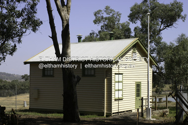
Photograph - Digital Photograph, Alan King, Yarrambat Heritage Museum, 23 January 2008
Original Yarrambat Primary School building at the Yarrambat Heritage Museum, Yarrambat Park. At the museum, visitors can gain an insight into Yarrambat’s past since non-Aboriginal settlement. The museum includes the original Yarrambat Primary School, which was moved to the site in 2000 and now serves as the Yarrambat Historical Society headquarters.The museum also includes a fully operational battery (gold-bearing ore crusher) driven by a McDonald 30HP diesel engine built in Richmond in 1938. The battery was relocated from the Golden King Mine in North Oatlands Road, Yarrambat, where it operated until 1984.1 Other exhibits include farming implements and machinery from the Yarrambat district. Published: Nillumbik Now and Then / Marguerite Marshall 2008; photographs Alan King with Marguerite Marshall.; p25This collection of almost 130 photos about places and people within the Shire of Nillumbik, an urban and rural municipality in Melbourne's north, contributes to an understanding of the history of the Shire. Published in 2008 immediately prior to the Black Saturday bushfires of February 7, 2009, it documents sites that were impacted, and in some cases destroyed by the fires. It includes photographs taken especially for the publication, creating a unique time capsule representing the Shire in the early 21st century. It remains the most recent comprehenesive publication devoted to the Shire's history connecting local residents to the past. nillumbik now and then (marshall-king) collection, yarrambat heritage museum, yarrambat historical society, yarrambat primary school -
 Linton and District Historical Society Inc
Photograph, Mrs. Emma Brown, 1870-1954
Emma Mercer was born in 1870 and lived at Spring Vale (now Pittong) at the Mercer property "The Pines". Emma worked as a teacher and head teacher at several schools, including Mortchup, Chepstowe, Kiata and Tarilta. In 1916, after she had retired from teaching, she married James Brown, a widower, one of a large farming family at Chepstowe. They had no children. James' brother David was married to Emma's sister Elizabeth (Bessie), and after James Brown died in 1931, Emma moved to live near her sister at Pittong. Emma Brown died in 1954. Emma and her sister Bessie were very involved with the war effort during World War I, and after the war they were presented with certificates of appreciation by the Linton "Diggers". (Copies of certificates in the LDHS collection.)Black and white copy of a studio portrait showing a lady standing behind a wooden gate. She is wearing a white high collared blouse with brooch and pendant, and a dark coloured jacket and long skirt. (nee Mercer)"Emma Brown nee Mercer"emma brown née emma mercer -
 Orbost & District Historical Society
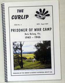
book, The Curlip - P.O.W.Camp Bete Bolong, Vic. 1943-1946, August 2007
This is Issue No. 5 of "The Curlip". The magazine is a compilation of research from a trip by the Orbost & District Historical Society to Bete Bolong. The Bete Bolong Prisoner of War Camp was located on the south side of the Buchan - Orbost Rd. From November 1943 to November 1945, Italian prisoners of war were based at Bete Bolong, cultivating maize, peas, beans and other vegetables on local farms. Unlike other 'farming' prisoners of war, those at Bete Bolong did not live with the farming families, but at a Prisoner of War Control Centre on Crown land overlooking the Snowy River Flats. About fifty Italian prisoners lived at the centre, along with an Australian Military Force staff of approximately seven people. The prisoners were driven to and from the farms each day. Three of them apparently simply swam across the river to work. They worked a six day week, with Sundays off. Although they were provided with rations, both prisoners and staff maintained vegetable and flower gardens. They were also skilled at cooking 'anything' they could catch, and at making illegal "grappa". Very few of the Italians were experienced farm workers. Some of them used their skills to make things for the families they worked for; a cabinet-maker made furniture , a cobbler made shoes, etc. They interacted with the local community and, although they were not supposed to go within one kilometre of town, some were found at local dances on Saturday nights. As recreation the prisoners were allowed to walk along the road to the west of the camp. Local people from both sides of the river could hear them sing as they walked. The prisoners also helped to construct an 'ant bed' tennis court on a property adjacent to the centre. Although now overgrown, the site of the tennis court can still be discerned as a flat area above the site of the centre. (ref./vhd.heritagecouncil.vic.gov.au)This item is a useful reference tool on the history of the Prisoner of War Camp at Bete Bolong, Orbost.A spiral bound book with a clear plastic cover. On the front is a coloured photograph of a view from the site of the P.O.W. camp at the intersection of Bete Bolong and Buchan Roads at Bete Bolong. Above is the title "Prisoner of War Camp Bete Bolong, Vic. 1943-1946" in black print on a white background. p.o.w.-camp-orbost ww11 bete-bolong -
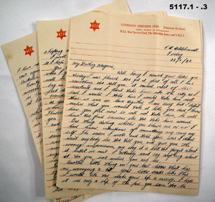 Bendigo Military Museum
Letter - LETTERS, Australian Comfort Fund
See Cat 5109P1-3. Three page letters written in ink. The paper has the Australian Comforts Fund letterhead in red ink (RSL, Salvation Army & YMCA) - addressed to "My darling Marjorie" signed "From your loving boyfrien Ted". He mentions - Anniversary of the day the Japs "chased us out of Rabaul" air raids. He is in Victoria at time of writing. 4-5. Two page letter written in ink to "My Darling from "Love and kisses" Yours Ted. The letter is written from Goodnight, via Tooleybuc NSW 29 - 9 -1942. He mentioned farming, Bendigo and an electric iron surprise. 6 - 8. Three page letters on Comforts Fund letterhead paper. Written at 107 Con Depot, Ballarat. To "My Darling Marjorie" from "Love and Kisses" Yours Only Ted. He mentions weather, chocolate soldiers, Americans, Guadalcanal, here in Ballarat.ww2, romance, ballarat, americans -
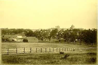 Kew Historical Society Inc
Photograph, J F C Farquhar, Kew Asylum & Grounds, 1891
At the beginning of the 1890s, the Kew businessman and Town Councillor, Henry Kellett, commissioned J.F.C. Farquhar to photograph scenes of Kew. These scenes included panoramas as well as pastoral scenes. The resulting set of twelve photographs was assembled in an album, Kew Where We Live, from which customers could select images for purchase.The preamble to the album describes that the photographs used the ‘argentic bromide’ process, now more commonly known as the gelatine silver process. This form of dry plate photography allowed for the negatives to be kept for weeks before processing, hence its value in landscape photography. The resulting images were considered to be finely grained and everlasting. Evidence of the success of Henry Kellett’s venture can be seen today, in that some of the photographs are held in national collections.It is believed that the Kew Historical Society’s copy of the Kellett album is unique and that the photographs in the book were the first copies taken from the original plates. It is the first and most important series of images produced about Kew. The individual images have proved essential in identifying buildings and places of heritage value in the district.When the Kew Lunatic Asylum was opened in 1871, its extensive 340 acres of grounds were intended for farming, agriculture and recreation for the inmates. The point-of-view chosen by Farquhar for this panoramic photograph focuses on the ordered open fields, haystacks and remnant trees that extended from the foreground to the rear of the Asylum. The inmates are the absent players in this pastoral idyll. In 1891, The Argus reported on the Annual Asylum Picnic: “Wednesday saw the Kew picnic, the yearly festival of the mad folks and their keepers. Once a year the public subscribes for cakes and ale for all these mad folks, and their keepers, from superintendent to lowest wardsman, turn out, and use their best endeavours to make one day in the year sanely merry.” Regardless of such merriment, the Asylum’s development and ongoing status were frequently a source of disquiet to the residents of Kew, who regularly petitioned the State Government for its removal. Despite these views, the Asylum was to remain a functioning institution from 1871 to 1988. Kew Asylum & Groundskew illustrated, kew where we live, photographic books, henry kellett, kew lunatic asylum -
 Kew Historical Society Inc
Photograph, J F C Farquhar, The Yarra in Hyde Park, 1891
At the beginning of the 1890s, the Kew businessman and Town Councillor, Henry Kellett, commissioned J.F.C. Farquhar to photograph scenes of Kew. These scenes included panoramas as well as pastoral scenes. The resulting set of twelve photographs was assembled in an album, Kew Where We Live, from which customers could select images for purchase.The preamble to the album describes that the photographs used the ‘argentic bromide’ process, now more commonly known as the gelatine silver process. This form of dry plate photography allowed for the negatives to be kept for weeks before processing, hence its value in landscape photography. The resulting images were considered to be finely grained and everlasting. Evidence of the success of Henry Kellett’s venture can be seen today, in that some of the photographs are held in national collections.It is believed that the Kew Historical Society’s copy of the Kellett album is unique and that the photographs in the book were the first copies taken from the original plates. It is the first and most important series of images produced about Kew. The individual images have proved essential in identifying buildings and places of heritage value in the district.Hyde Park is now a small recreation reserve bordered by Willsmere and Kilby Roads and White Avenue. In 1982, Hyde Park was cut off from the Yarra River by the construction of the Eastern Freeway. The building of the latter was to transform the natural landscape, including the Yarra, as well as Hyde Park. The construction of the Freeway makes it difficult to view the scene with the photographer’s eye. Today’s Hyde Park is located on land purchased in 1847 by John Cowell, and in 1851 Catherine Cowell, yet the scene selected by the photographer may well have been located on farmland owned by the Wills family. Farquhar’s point-of-view emphasises both the pastoral and recreational elements of the scene: the grazing cows, three boys, and in the distance two figures, seated on the bank with a parasol. By 1891, an environmental consequence of human activity, including farming, was deforestation, leading to the erosion of the south bank of the Yarra. In contrast, the land on the Alphington side of the river in 1891 included remnant bushland.The Yarra in Hyde Parkkew illustrated, kew where we live, photographic books, henry kellett, yarra river -
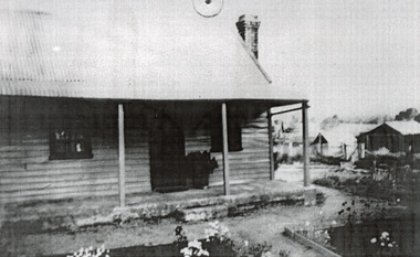 The Beechworth Burke Museum
Photograph, c1900
This photograph shows a small timber house in Wooragee. In 1855, the Ovens district made a shift towards farming development that included the sales of land in the Wooragee Valley. This shift came because of miner's demands and concern about stabilising the area around the goldfield. Continual migration needed to be supported, unlucky diggers needed alternative employment, and there was a lack of affordable fresh produce available on the goldfields. Initially, the cost of land in areas like Wooragee was prohibitive, and miners chose to squat rather than overpay for poor land. Throughout the 1850s and 1860s, land reform was a key topic for miners and politicians, as they attempted to improve land access and protect financial interests. This photograph is an example of rural development in the Wooragee area, showing the cottage, tents, and garden beds. While the date is unknown, the image nevertheless links us to the 1850s-1860s story of rural development in Indigo Shire. Black and white rectangular photo, copy of original, printed on paper. wooragee, timber, timber cottage, corrugated iron, cottage, housing, tents, gardening, farming, farming and agriculture, construction, garden bed, flowers, verandah, squatting, tent, field -
 The Beechworth Burke Museum
Audio - Oral History, Jennifer Williams, Hubert Warner, 2 April 2000
Hubert Warner’s story shows insight to the families that emigrated from Europe for the gold rush. It illustrates the nuances of life in the district. This history speaks of land cultivation and the innovation of industry in the region, in particular sheep and cattle farming and slaughter. Warner speaks of the highs and lows of the practice of breeding cattle, the awards he won, but also the hardships that come with working on the land such as having to face natural disaster. This oral history recording was part of a project conducted by Jennifer Williams in the year 2000 to capture the everyday life and struggles in Beechworth during the twentieth century. This project involved recording seventy oral histories on cassette tapes of local Beechworth residents which were then published in a book titles: Listen to what they say: voices of twentieth century Beechworth. These cassette tapes were digitised in July 2021 with funds made available by the Friends of the Burke.Hubert Warner's account of life in Beechworth is uniquely illustrative as it captures many aspects of the community. It explains the motivation for European migrants for choosing to settle in the area and how they were able to both become a part of and create a presence in their local community. This oral history also exemplifies the process of developing industry through the twentieth century, how it was done, the struggles it faces, and the triumphs that came with this. Warner's history is specific to the cattle industry and shows great nuance in the day-to-day operation of such a business over time. This is a digital copy of a recording that was originally captured on a cassette tape. The cassette tape is black with a horizontal white strip and is currently stored in a clear flat plastic rectangular container. It holds up 40 minutes of recordings on each side. Herbert Warnerlisten to what they say, listen to what they say: voices of twentieth century beechworth, 1800s beechworth, 20th century beechworth, beechworth, farming and agriculture, cattle, gold, gold rush, farm, farming -
 Eltham District Historical Society Inc
Photograph - Digital Photograph, Alan King, Original Kangaroo Ground Primary School No. 2105 building, Eltham-Yarra Glen Road, Kangaroo Ground, 28 December 2007
Kangaroo Ground's first school began in 1851 with 22 pupils from the district's ten families. It was a single room school located further south on the site, which also served as a Presbyterian church. The first teacher was Andrew Ross. The school building was used as a Post Office between 1854 and 1858 and during 1857 also served as a Court of Petty Sessions. With a growing farming community, a new building was warranted and the original Sate School No. 352 was closed and a new building, State School No. 2105 was oipened October 1, 1878. A residence for Head Teacher Henry Wallace School was erected in 1879 attached to the left of the school building. That residence is now home to the Andrew Ross Museum, which opened in 1993. Covered under Heritage Overlay, Nillumbik Planning Scheme. Published: Nillumbik Now and Then / Marguerite Marshall 2008; photographs Alan King with Marguerite Marshall.; p35This collection of almost 130 photos about places and people within the Shire of Nillumbik, an urban and rural municipality in Melbourne's north, contributes to an understanding of the history of the Shire. Published in 2008 immediately prior to the Black Saturday bushfires of February 7, 2009, it documents sites that were impacted, and in some cases destroyed by the fires. It includes photographs taken especially for the publication, creating a unique time capsule representing the Shire in the early 21st century. It remains the most recent comprehenesive publication devoted to the Shire's history connecting local residents to the past. nillumbik now and then (marshall-king) collection, kangaroo ground, eltham-yarra glen road, kangaroo ground primary school no. 2105, kangaroo ground state school, state school no. 2105 -
 Orbost & District Historical Society
ledger, 1. 8. 1915 - 30 .6. 1923
This ledger was kept by the management of a rural property in Marlo, East Gippsland. Entries were made by Hugh Cameron and Alaster Cameron. Their property was reputed to be the largest private dairy producer in Australia at one stage. (ref. Mary Gilbert) Some station owners or managers kept records like diaries, wage and ration books, and registers of births, deaths and marriages. This one records federal transactions, costs of produce and payments for share farming at Brodribb and Marl, as well as a list of donations made. Hugh Cameron (1850-1921) was on the Orbost Shire council from 1892-1915. His son Alaster was also an Orbost Shire councillor representing the East riding from 1932 to 1954. Hugh died at Orbost on 3rd May 1921, aged 71, and was buried on 5th May at the Orbost cemetery. (more info. in O.D.H.S. newsletter -Tambo Shire)This is an example of record keeping on rural properties in the first half 20th century. It is associated with the Cameron family who were early settlers in the Orbost district.A large leather bound ledger with a dark blue patterned cover and suede leatherette binding and corners. There are pages with alphabetical indexing. Some pages are ruled for accounts. All entries are hand-written in blue or black ink.There is blotting paper inside.on spine on red leatherette in gold print - " "STATION LEDGER" and on black in gold print - "CLOVERDALE"cameron-marlo dairy-farm-cameron agriculture-records station-ledger-cameron