Showing 2496 items
matching gardens and parks
-
 Ballarat Tramway Museum
Slide - 35mm slide/s, Peter Moses, Jan. 1966
Photo of SEC Ballarat Tram No. 11, west bound after leaving Victoria St. terminus crossing the Buninyong or Eureka Siding railway Bridge. Tram fitted with a "Twin Lakes" and SEC Briquettes roof advertisement and has destination of "Gardens via Sturt St. West". On the left side of the photograph is a roadside advertisement for the "Eureka Caravan Park". Note scanning error in the photograph. Kodak cardboard mount slide, taken by Peter Moses January 1966. Actual slide does not give the year, but slide fitted in with numbering sequence for 1966.On back of slide in blue ink in bottom right hand corner "P. Moses".tramways, trams, victoria st, railway bridge, tram 11 -
 Ballarat Tramway Museum
Photograph - Black & White Photograph/s, John Phillips, 28/01/1980 12:00:00 AM
Yields information about the operation of a Ballarat (ex Melbourne) tram in Melbourne during an Australia Day celebrations by the BTPS and the city skyline at the time.Colour photograph of BTM Ballarat Tram No. 40 Wellington Parade, Melbourne on 28 Jan. 1980 with S164 in the background. Tram showing Gardens via Sturt St destination with an East Melbourne Auxiliary Board. Taken during the Australia Day celebrations. Taken by John Phillips. Another of the heritage buses are parked alongside. In the background is the Melbourne skyline with the 3DB and HSV 7 signs on the Herald building prominent, Cheneys and in the middle distance is the construction of the State Bank Building. Taken just after btm4131, and a wider view, with the Citicorp Building in the background as well.tramways, trams, australia day, wellington parade, melbourne, btps, tram 40 -
 Kew Historical Society Inc
Plan - Subdivision Plan, J R Mathers & McMillan, Normanby Estate, c.1913
The Kew Historical Society's map collection includes a substantial number of real estate subdivision plans, mainly of Kew but also of surrounding suburbs in Melbourne. Most of the subdivision plans date from the 1920s and 1930s when the districts old homes and local farmland were being split up to accommodate residential growth in the postwar period. These early plans were assembled by a local firm, Jas R Mather & McMillan, which had an office in Cotham Road. Many of the plans, and sometimes photos, were annotated by the agents.Subdivision plans are historically important documents used as evidence for the growth of suburbs in Australia. They frequently provide information about when the land was sold as well as evidence relating to surveyors and real estate and financial agents. The numerous subdivision plans in the Kew Historical Society's collection represent working documents, ranging from the initial sketches made in planning a subdivision to printed plans on which auctioneers or agents listed the prices for which individual lots were sold. In a number of cases, the reverse of a subdivision plan in the collection includes a photograph of a house that was also for sale by the agent. These photographs provide significant heritage information relating house design and decoration, fencing and household gardens.The photograph may also be aesthetically significant depending on the importance of the photographic atelier.The Normanby Estate, which was adjacent to Normanby Road, Kew East, included thirty-one lots for sale. Streets on the subdivision plan include Adeney Avenue, Park Hill Road, Normanby Road, Weir Street and Wharton Street. Cotham Road and its tramway are shown nearby. The plan is interesting as it shows Wharton Street, named after the architect and town planner George Wharton, who was the first chairman of the Municipality of Kew. The street was to later be renamed Cecil Street. Also shown are proposed ‘Municipal Gardens’ where Parkhill Drive is now located."D" in top left corner. Stamped auctioneers contact details: "Jas. R. Mathers & Son & McMillan / Auctioneer & Land Salesmen, / 271 Collins Street / Melbourne" and Jas. R. Mathers / Estate & Financial Agent / Cotham Road / Kew".weir street - kew, wharton street - kew, normanby road - kew, cotham road - kew, municipal gardens - kew, park hill parkhill road - kew, braemar - kew, subdivision plans - kew -
 Kew Historical Society Inc
Plan - Subdivision Plan, Normanby Estate, East Kew, 1913
Pru Sanderson, in her groundbreaking ‘City of Kew Urban Conservation Study : Volume 2 - Development History’ (1988), summarised the periods of urban development and subdivisions of land in Kew. The periods that she identified included 1845-1880, 1880-1893, 1893-1921, 1921-1933, 1933-1943, and Post-War Development. These periods were selected as they represented periods of rapid growth or decline in urban development. An obvious starting point for Sanderson’s groupings involved population growth and the associated economic cycles. These cycles also highlighted urban expansion onto land that was predominantly rural, although in other cases it represented the decline and breakup of large estates. A number of the plans in the Kew Historical Society’s collection can also be found in other collections, such as those of the State Library of Victoria and the Boroondara Library Service. A number are however unique to the collection.The Kew Historical Society collection includes almost 100 subdivision plans pertaining to suburbs of the City of Melbourne. Most of these are of Kew, Kew East or Studley Park, although a smaller number are plans of Camberwell, Deepdene, Balwyn and Hawthorn. It is believed that the majority of the plans were gifted to the Society by persons connected with the real estate firm - J. R. Mathers and McMillan, 136 Cotham Road, Kew. The Plans in the collection are rarely in pristine form, being working plans on which the agent would write notes and record lots sold and the prices of these. The subdivision plans are historically significant examples of the growth of urban Melbourne from the beginning of the 20th Century up until the 1980s. A number of the plans are double-sided and often include a photograph on the reverse. The Normanby Estate, which was adjacent to Normanby Road, Kew East, included thirty-one lots for sale. Streets on the subdivision plan include Adeney Avenue, Park Hill Road, Normanby Road, Weir Street and Wharton Street. Cotham Road and its tramway are shown nearby. The plan is interesting as it shows Wharton Street, named after the architect and town planner George Wharton, who was the first chairman of the Municipality of Kew. The street was to later be renamed Cecil Street. Also shown are proposed ‘Municipal Gardens’ where Parkhill Drive is now located.subdivision plans - kew, normanby estate -
 Melbourne Tram Museum
Document - Form/s, Melbourne & Metropolitan Tramways Board (MMTB), "Particulars of Loading", 1933
Form 104 - titled "Particulars of Loading" - giving tramcar passenger capacity, location, date, counted by, time, tram number, destination, and passengers. 1. - Prahran line. At Chapel St & Toorak Rd. Dated 10 & 11/2/33. Cricket - Victoria v South Australia 2. - Toorak line. At Park St & Domain Rd. Dated 19/2/33. Symphony orchestra recital at Botanical Gardens 3. - Prahran line. At Chapel St & Toorak Rd. Dated 3/3/33. Cricket - Victoria v England at MCGtrams, tramways, mmtb, tramcars, passenger services, inspectors, reports -
 Ringwood and District Historical Society
Pamphlet, Heathmont Uniting Church Community Lifestyle Centre, 2024
Multi-fold leaflet with summarised past community leaders' tributes and map showing parks and other local Ringwood and Heathmont facilities bearing their names.McAlpin Reserve, Douglas Maggs Reserve, Mahon Reserve, Loughies Bushland, Peter Vergers Reserve, B.J. Hubbard Reserve, Kevin Pratt Pavilion, Staley Gardens, Greenwood Park, A.F.B. Long Reserve, R.O. Spencer Pavilion, Russell Lucas Oval, Fred Dwerryhouse Pool, Herman Pump Reserve, A.C. Robertson Field, F.J.C. Rogers Reserve, Harpers Bush, A.G. Lavis Pavilion, Dexters Bush, H.E. Parker Reserve. -
 Eltham District Historical Society Inc
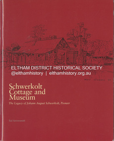
Book, Ted Arrowsmith, Schwerkolt Cottage and Museum; The legacy of Johann August Schwerkolt, Pioneer, 2004
A comprehensive history of the Schwerkolt family in Mitcham, based on extensive research and documents from family sources. Schwerkolt Cottage is a pioneer cottage built around 1880 at Mitcham, Victoria. This heritage site encompasses the original stone cottage, associated replicated outbuildings and a local history museum, surrounded by 2.25 hectares of gardens and bushland, and adjacent to Yarran Dheran bushland park. Lifetime member Doug Orford sold his house in Napoleon Street November 2023 and has moved into a care faciity. His daughter Cathy assisted him in identification of items for donation to the Society.johann august schwerkolt, pioneer, schwerkolt cottage and museum -
 Kew Historical Society Inc
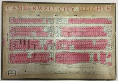
Plan - Subdivision Plan, Jas R Mathers Son & McMillan, Camberwell City Heights, 1922
"Following the 1919 amalgamation of suburban tramway trusts, an electrified tram service extended along Doncaster Road. Housing estates such as the 1919 Balwyn Park Estate, 1922 Hillcrest Estate and the Camberwell City Heights Estate, also 1922, quickly followed. These estates were built over by expansive suburban villas, set in fine gardens and along tree-lined streets. North Balwyn, largely constructed since 1933, was typified by even grander houses, many of them in the 'ocean liner' style and seen at their most distinctive in the Riverview Estate." (Source; 'Balwyn' in eMelbourne)Portions of subdivision plan mounted on both sides of cardboard sheet. Coloured pink, probably to show allotments sold. Area covered: Doncaster Road, Mountainview Road, Panoramic Road, Cityview Road, Longview Road, Riverview Road, Hillview Road, Bulleen Road. Includes location diagram showing railway lines and existing and proposed tram routes.Cardboard backing has advertisement for "Tillock's soluble coffee"subdivision plans -- camberwell (vic.), camberwell city heights subdivision -
 Melbourne Tram Museum
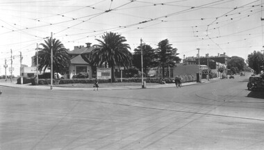
Photograph - Candy Corner - St Kilda - opposite Luna Park - Esplanade, Early 1940s
Photograph shows the cafe and adjacent buildings on the area that was enclosed by Esplanade tram Loop or Luna Park loop. Known as "Candy Corner" on MMTB drawings and locally. The reference page 9 gives the background to the site and its use. The café was designed by Carlo Catani, who is also remembered as the landscape designer for other parts of St Kilda including Catani Gardens. It is now used by a McDonalds store. In front of the building is a board advertising or promoting World War 2 war-saving schemes for St Kilda streets. This dates the photos to early 1940s.Yields information about Candy Corner buildings Black and white photograph on paper.trams, tramways, luna park loop, candy corner, st kilda, esplanade, loops, carlo catani, world war 2, street savings scheme -
 Bendigo Historical Society Inc.
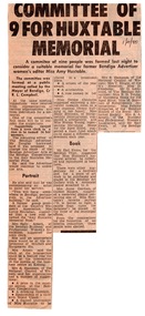
Article - Amy Huxtable Memorial Committee - Newspaper Articles, 1980-81
Amy Huxtable was born at Cheltenham in 1918, to Robert Henry Huxtable and Violet A Dagg. Her father was an installer for an oil company and travelled the State. taking his family with him. She completed her education at the Bendigo High School and later attended the Bendigo Business College, becoming an expert shorthand writer. Her first position was as a copy writer with Radio 3BO, in the mid 1930s. She worked with an advertising agency in Melbourne and then with the Age,newspaper. In 1953, Miss Huxtable was appointed temporarily to succeed Miss E B Millane as social editress of the Bendigo Advertiser, during the latter's absence abroad. In 1956, Amy travelled abroad and on her return in 1957 was appointed permanently as Women's editor, a position she held for twenty-three ears. During her early years with The Advertiser she wrote under the name Toora, but in later years her own name became widely known. Miss Huxtable was well known both in her professional capacity and through a interest and involvement in community activites. She was life governor of the Bendigo Hospital, the Bendigo Home for the Aged, and Mirridong Home for the Blind, she was a member of Soroptimist International and the Business and Professional Women's Club. Amy was also a tireless worker for the spastic society and a strong supporter of the YWCA. When Amy Huxtable died at Mt AJvernia Hospital on 16 January 1980 Mayor Campbell ordered the city flag to be flown at half-mast. "Lowering the flag is the least we can do for such a lady" Cr Campbell said. Douglas Lockwood, editor of the Bendigo Advertiser said, "She was a devot d colleague who gave her craft and her newspaper the kind of service which identified a rare and generous spirit." She was a true professional who decided to make Bendigo her home. More than 300 people packed St Paul's Church for her funeral ervice the bell tolled as the casket was carried from the church. At a ceremony in the Conservatory Gardens on No ember 22 1981 The Amy Huxtable Memorial Committee presented to the City of Bendigo, a garden seat in memory of the late Miss Huxtable. This Bendigo manufactured seat was a fitting tribute to one ofBendigo's most loved and esteemed citizens. All Miss Huxtable's Advertiser articles were microfilmed and presented to the Library by the above committee. Amy Huxtable Memorial Seat - Bendigo Conservatory Gardens. Four Newspaper articles from the Bendigo Advertiser: 2808.7a Article entitled " Committee of 9 for Huxtable Memorial 1/4/1980". Describes how the Mayor of Bendigo called for a committee to consider a suitable memorial to Amy, the former Bendigo Advertiser women's editor. Also mentions a portrait to be painted and hung in a prominent location, perhaps the Advertiser Office. There were a number of other suggestions to honour her including a book to be produced containg Miss Huxtable's numerous history articles. 2808.7b A public notice 21/11/1981 from Miss N Young, President, Amy Huxtable Memorial Committee, inviting people to the presentation of the Amy Huxtable Memorial Seat to the City of Bendigo at the Conservatory Gardens on Sunday Nov 22 1981 2808.7c Article contains a photo of the seat being installed by the Superintendant of Bendigo Parks and Gardens Andrew Taylor, and the deisgner, President of the Memorial Committee Bill Delecca. It acknowledges the seat was bought by the Committee and the Business and Professional Women's Club. 2808.7d Article advising that the Bendigo City Council had granted approval for the seat.history, amy huxtable, bendigo, amy huxtable memorial committee, bendigo professional women's club, bendigo conservatory gardens -
 Eltham District Historical Society Inc
Photograph, Peter Pidgeon, Memorial to Gordon Craig Ford, Landscape Designer, Eltham Cemetery, Victoria, 5 April 2021
Gordon Ford was a conservationist and a pioneer of natural-style landscaping. He came to Eltham in 1948 and bought a block of land in John Street extending through to Pitt Street. Artist Peter Glass lived opposite in John Street. Early on, Gordon worked for Alistair Knox on construction of the mudbrick Busst house amongst others. At the same time, with the help of friends including artist Clifton Pugh, he progressively built his own house ‘Fülling’, which "grew like Topsy" utilising a variety of second-hand materials. His main focus, which became his life-long occupation, was garden landscaping. Inspired by Edna Walling and Ellis Stones, he sought to reflect the bush settings of rural Victoria where he had grown up. Commissions included Monash University and countless industrial sites but designing for the archetypal quarter-acre block gave him the most satisfaction. He had a huge impact on the look of gardens in Australia from the 1950s, creating seemingly natural bush environments by carefully integrating indigenous and exotic plantings. Gordon died in 1999 and is buried in Eltham Cemetery; the gravesite is marked by a plaque. Another plaque (away from his grave) notes his landscaping design work within the cemetery grounds and at Alistair Knox Park. Gordon Craig Ford Landscape Designer 30. 8 .1918 - 16. 6. 1999 Eltham Cemetery Trustee fom 1987 - 1999 Gordon settled in Eltham in 1948 He was a conservationist and a pioneer of natural style landscaping, continuing design and construction until his death. His local work and influence can be seen in many private gardens, the Eltham Cemetery and the Alistair Knox Park.Born Digitaleltham cemetery, gravestones, gordon craig ford -
 Mortlake and District Historical Society
Photograph - Montgomery Pavillion, Montgomery Pagoda or Pavillion, 1924
In July 1922 Rev. W. McBride of the St Andrews Presbyterian Church, Mortlake had a meeting with the Garden sub-committee to discuss how the 500 pounds sterling bequest from the Late Thomas Montgomery could best be spent. His suggestion was that the money should be spent on either a kiosk, pavillion or recreation hall and pavillion combines with kitchen and fireplace was agreed to with exact site to decided at a public meeting. Cr Montgomery, a local businessman and a councillor, had loved the gardens and had assisted to transform the area from a swamp into a thing of beauty. The design was chosed by his widow who had seen a smilar design in King's Park whilst in Perth so the plans were obtained from that City. The work was carried out by Archibald Cluny McDonald and completed in September 1924. In December 1924 the Montgomery Pagado was unveiled to the public by Cr Wells Brumley after which the Red Cross ladies served tea.THIS TABLET IS DESIGNED TO COMMEMORATE THE GENEROSITY OF THE LATE COUNCILLOR THOMAS MONTGOMERY BY WHOM THIS PAVILLION WAS GRACIOUSLY BEQUEATHED TO THE TOWN OF MORTLAKE AND TO PERPETUATE THE MEMORY OF HIS NOBILITY OF CHARACTER AND EXTREME WORTH AS A CITIZENpagoda -
 Mortlake and District Historical Society
Lone Pine
This pine tree (Allepo Pine, Pinus halepensis) a native of the Gallipoli Peninisula (Gelibolu, Turkey), was grown from a cutting obtained from the War Memorial Canberra and planted in the Mortlake Botanic Gardens in 2002. It replaces the original which grew outside the Mortlake RSL Hall which blew down in a storm c.2000. That tree (Allepo brutius)came from 'the original on Gallipoli' and was planted to commemorate 'fallen comrades' in 'the Jubilee year 1965.' However, two soldiers first brought home pine cones direct from that fateful battlefield. . One was Sgt. Keith McDowell of the 24th Btn. His aunt, Mrs. Emma Gray of Grassmere (Vic.) planted the seeds c. 1928 and four seedlings resulted. One was planted in Wattle Park, Melbourne, one at the Shrine of Remembrance, one at the Soldier's Memorial Hall at The Sisters (c.15 km. south of Mortlake) and one at the Warrnambool Botanic Gardens. The First World War (or 'Great War') and in particular the battle for the Gallipoli Peninsula is of immense national significance. Lone Pine or Plateau 400 was the scene of a major offensive on August 6th 1915. All the trees on the ridge at this point were cut down but one, which was dominated by the 'Lone Pine'. In three days of fighting more than 2,000 Australians lost their lives and seven Victoria Crosses were won. Two Australian soldiers souvenired pine cones - one was brought back to Victoria (see above). Many young men from Mortlake and district volunteered to fight in the Great War and the presence of this tree in our Gardens reminds us all of the local as well as the national sacrifice.l pine tree Small plaque on railing western side. gallipoli, lone pine first world war great war mcdowell, keith -
 Hepburn Shire Council Art and Heritage Collection
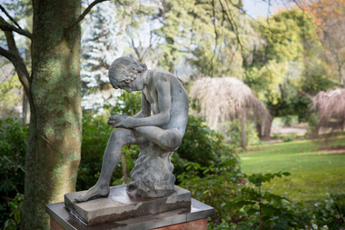
Public Art Work, Boy with a thorn - 'Lo Spinario', c. 1900
Boy with a Thorn Though the classical bronze that the figure was modeled has become known as Lo Spinario, both Stuart Rattle and Kevin O’Neill referred to it as The Boy with a Thorn. Information from the late Stuart Rattle and John Graham, the late Kevin O’Neill’s partner. The statue was bought by Kevin O’Neill from a South Yarra antique dealer in the 1980s. She had bought it in Europe. Stuart believed that it was cast in Berlin by Moritz Geiss who had pioneered the popular process of zinc casting of classical statues. Schinkel, the architect of early 19th Century Prussian public buildings used the process extensively. I assume that the decorations that can be seen in Berlin currently are copies of those copies, given the comprehensive destruction of the city in 1945. Unless there is a date stamped on the statue, and there might well be, there is no firm indication of its age, although Stuart and Kevin believed it was “turn of the century”. It was given to Stuart by John Graham after the death of Kevin O’Neill. Prior to its installation at Musk Farm, it was “by the dam” at Marnarnie, O’Neill’s property at Mt Macedon. It became a much photographed focal point in the sunken garden at Musk Farm. The statue is a gift from the Rattle family to The Friends of Wombat Hill Botanic Gardens who intend to give it, in turn, to Hepburn Shire to be placed in the Botanic Gardens. Both the family and the Friends see it as a memorial to Stuart’s tireless work to raise funds for the Gardens and to raise the profile of the Gardens so that their considerable significance could be more broadly acknowledged. The CMP notes that statuary has been a feature of most botanic gardens (and a notable feature of the Ballarat Botanical Gardens) and James Lowe, the head of Parks for the Shire has also commented that it is an area that could well be developed in the Gardens. This comes from his attendance at meetings of the BGANZ, the “peak professional body” for the development and maintenance of registered botanic gardens in Aus and NZ. Given the lack of funds that the Shire has been able to allocate to the Gardens, a donation of this calibre is a welcome addition to the cultural asset that the Gardens represent. A very large number of residents of the Shire are members of the Friends, have visited Musk Farm and are appreciative of the Gardens. There is a current feeling that the Gardens are undergoing a dynamic revival as a result of the success of the Café and also because of the extraordinary improvement and enhancement of the amenity that has been undertaken over the past two years by the Friends. The installation of the Boy with the Thorn is another move forward for the Gardens. The statue is cast zinc. It is sometimes referred to a white bronze. As can be seen in the photographs, it is in very good condition with no damage or apparent degeneration of the metal. The Smithsonian Institution has a lengthy document relating to the deterioration and repair of similar casts in the US where urban pollution has taken its toll but for the most part it deals with inappropriate repair rather than maintenance protocols. One of the properties of zinc that is appreciated in Australia is its ability to withstand the elements and given that the artwork has been either on Mt Macedon or at Musk for the last 30 years or more, its relocation to Wombat Hill seems to be an appropriate one. The Friends are prepared to organise and pay for the relocation of the statue. The issue of security from the point of view of theft, malicious damage and environmental impact will need to be addressed. The Ballarat Botanical Gardens have recently reinstalled statuary which has been damaged and which had been removed from the Gardens on account of this. They have used Rockworks Ballarat and Wilson’s Memorials to make plinths, secure artworks with steel pins and to provide especially robust fixings to ensure the safety of the various sculptures. The CMP (2007) makes a number of recommendations regarding security in the Gardens ranging from the installation of lighting to the locking of the gates overnight and the repair/reinstatement of appropriate fencing – not done as yet to my knowledge. Paul Bangay has also agreed to act as a consultant in the process of installing the Boy. John Graham estimates its value at $20,000 The preferred location for the work would be at the entrance to the Fernery from the lawn. The paths form an intersection at that point that could be modified to fit the statue. But this is currently a suggested location only. The statue is a gift from the Rattle family to The Friends of Wombat Hill Botanic Gardens who have gifted it to the Hepburn Shire to be placed in the Botanic Gardens. Both the family and the Friends of the Wombat Hill Botanical Gardens Daylesford see it as a memorial to Stuart’s tireless work to raise funds for the Gardens and to raise the profile of the Gardens so that their considerable significance could be more broadly acknowledged. Lo Spinario (Boy with a thorn) c. 1900 copy after the Greco-Roman Hellenistic antique bronze in Rome. c. 1900 copy after the Greco-Roman Hellenistic antique bronze in Rome (Palazzo dei Conservatori, Musei Capitolini, Rome) Manufacturer M. Geiss, Berlin Nonedaylesford, wombat hill botanical gardens, stuart rattle, kevin o'neill, john graham, boy with a thorn, lo spinario, classical sculpture, zinc, classical nude, hepburn shire, public art, sculpture, art -
![Book, Eltham District Historical Society, The Tower of Remembrance and War Memorial Park on Garden Hill at Kangaroo Ground, Victoria, 1919-2010 / [by Harry Gilham, Eltham District Historical Society], 2010](/media/collectors/4f729f7b97f83e03086018a5/items/5ed44ca221ea670c843ddece/item-media/5ed4512821ea670c84423b32/item-fit-380x285.jpg) Eltham District Historical Society Inc
Eltham District Historical Society IncBook, Eltham District Historical Society, The Tower of Remembrance and War Memorial Park on Garden Hill at Kangaroo Ground, Victoria, 1919-2010 / [by Harry Gilham, Eltham District Historical Society], 2010
A4 photocopies and Master sheets consisting of copies cut and pasted together for 2010 edition (pages 77 on) Also digital file of copy scanned from Council. Most pages from 77 on have page numbers added by hand not present on master sheets. Note: no page 63 (pagination error possible) First published 2002 The Tower of Remembrance and War Memorial Park on Garden Hill at Kangaroo Ground, Victoria, 1919-2001; Revised 2010. 109 p, : ill, ports., plans ; 30cm ISBN 0957719825 (2002) Eltham District Historical Society 2010 -
 Tatura Irrigation & Wartime Camps Museum
Artwork, other - Carl von Brandenstein Collection, Tatura Camp 1A
Dr Carl von Brandenstein was born in 1909 in Hanover, Germany. He studied oriental languages and the history of religion at Berlin University (1928-1934) and Leipzig (1938-1939). His doctoral thesis was a dissertation on the iconography of Hittite gods. He was arrested in Persia in 1941 and sent to Australia where he was interned at Loveday Camp South Australia and in Camp 1 Tatura from January 1945 until his release in August 1946.Four artworks in a dark wood frame with terracotta coloured matte. Item 1: Hospital Waranga. Tall gum trees in foreground, blue sky . Staff standing under the veranda and a red cross vehicle parked in front. A barbed wire fence surrounds the hospital. Item 2: Inside the Library. Item 3: Camp Barracks. Four huts in a row . A tree and garden in front. Item 4: Reading Room. A table in centre of the room with a single chair. Books and stationery items on the table. A lamp hangs from the ceiling. Bookshelves along the walls and paintings on the wall. Item 2: "am letzten Tage deiner Internierung dem lieben Hans Wulff fur Errinnerung an gemeinsam gebautes" (English Translation: On the last day of your internment to dear Hans Wiulff for remembrance of what we built together. camp 1, tatura, carl von brandenstein, internment camp loveday, waranga hospital, library, hans wulff -
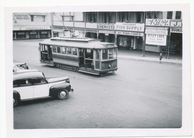 Ballarat Tramway Museum
Photograph - Digital image, Wal Jack, 20/03/1949 12:00:00 AM
Yields information the appearance of the SEC tramcar No. 23, which was often decorated in 1949 and the streetscape.Digital image from the Wal Jack Ballarat Album of trams No. 23 in Sturt St climbing the hill enroute to Gardens. Shows how the barrier rails were arranged. In front of the tram area a number of angle parked cars. In the rear are Patersons Furniture, Taylor and Taylor Chemists, Ballarat Fish Supply, Ritzy Cafe and Grill Rooms and a book store. The tram itself is looking shabby. Photo taken 20-3-1949. See image i2 for rear of photograph. See image i3 for hi res scan of print. See image i4 for hi res scan of negativeon rear of photo in ink, "SEC Ballarat, No. 23, in Sturt St, Ballarat 20-3-1949" and in top right hand corner Wal Jack copyright stamp with number "T99" written.trams, tramways, sturt st, city loop, tram 23 -
 Bendigo Historical Society Inc.
Document - PETER ELLIS COLLECTION: MARVELLOUS MELBOURNE BICENTANNIAL BALL, 29th April, 1988
Creamy Coloured Card folded in half. Marvellous Melbourne Bicentennial Ball The Royal Exhibition Building Carlton 29th April 1988. Order of Programme. 8.00pm Arrival 8.30 Welcome to Guests Dancing. 9.30 Dinner Dancing. 10.30 Announcement of Prizes. Addresses Dancing 2.00 am Close Music provided by the Wedderburn Old Timers. Menu Hot Chicken Entrée Selection Cold Meats & Salads Tipsy Cake Dinner Mints & Coffee. Acknowledgements Artwork - The Scriptorium Patricia Barth Hose Glassware Seppelt's Wines Trustees of the Exhibition Building Melbourne Parks and Gardens Proudly sponsored by 3AK.person, individual, peter ellis oam -
 Melbourne Tram Museum
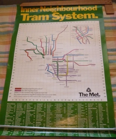
Poster, The Met, "Inner Neighbourhood tram system", mid 1980's
Poster, full colour printed on gloss paper titled "Inner Neighbourhood tram system", giving a diagrammatic Map of the tram system, suburbs, tram route destination names and route numbers and peak service route numbers. Has a separate section for the City area. Shows the routes that ran into the Greensborough and Box Hill Neighbourhoods. At the base of the map has The Met logo and name, a customer service number which has been glued over the printed number. At the base of the poster is a location guide for places of interest, sporting facilities, parks and gardens, railway stations etc.trams, tramways, the met, map, tickets, neighbourhood tickets, tramways -
 Ballarat Tramway Museum
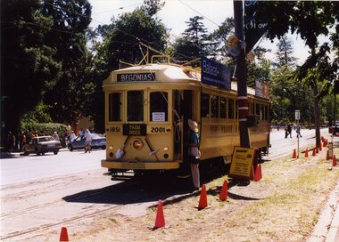
Photograph - Colour Photograph/s set of 6, Carolyn Dean, 10/03/2001 12:00:00 AM
Set of six photographs taken by Carolyn Dean on 10.03.2001 of operations in Wendouree Parade during the 2001 Begonia Festival. Printed on Kodak paper. 1786.1 - Gold tram 45 - at Gardens Loop, heading south, with destination "Begonias". Has witches hats and special stop boards in view. Also advertising Ballarat Eureka and Sovereign Hill. .2 - Tram 33 - south bound at Depot Junction with Peter Winspur talking to crew. Has Ice Cream Man van in background. .3 - Gold tram 45 at Depot Junction, southbound, showing destination "Car Park" with Dave Macartney in view and another crew member (Phillip Bertram) in uniform holding the megaphone. .4 - Tram 33, showing "Depot" near Depot Junction, running northbound. .5 - Gold tram 45, at same location, showing "Car Park", northbound and Bendigo Cafe tram advertising board. .6 - as for .3, with Phillip Bertram in photo holding megaphoneAll have date "10.03.01" and "Photo Carolyn Dean" written on the back in blue ink.begonia festival, gold tram, depot junction, gardens loop, wendouree parade, btm, tram 45, tram 33 -
 Eltham District Historical Society Inc
Album - Photograph Album, Alan Gardiner, M.M.B.W Braeside Sewage Treatment Plant Construction, 1939
In April 1928 the MMBW had the land and the plans for what they were to construct but the timing of the actual building did not proceed as planned. Before the construction could commence the Great Depression of the 1930s intervened forcing the shelving of its plans. The new owners then offered the land for lease resulting in Frederick Werrett taking the opportunity to take up the land he formerly owned to continue his market gardening activities of growing potatoes, onions and other crops. The land and improvements made by Syme were leased in 1929 to Harry Telford a trainer from New South Wales. Phar Lap grazed there for a short time. [9] However the population of Melbourne continued to grow and the need for a sewerage treatment plant did not go away. In 1939 when the effects of the Depression had dissipated work on the Sewerage Effluent Treatment Plant commenced and the following year in October the Premier of the State, Albert Dunstan, officially commissioned it. The Sewerage Effluent Treatment Plant at Braeside served the communities of south-east Melbourne for thirty five years until 1975. In that year all the sewers that entered the Braeside plant were diverted to the South Eastern Trunk Sewer complex at Carrum.[10] In 1982 the chairman of the MMBW at that time, Alan Croxford, announced that a substantial part of the property at Braeside would be administered by the Parks and Gardens section of MMBW as a public park. Subsequently the responsibilities were transferred to Parks Victoria, the situation that exists today. It is known as “Braeside Park” now. [Source: Sewerage Treatment Plant at Braeside, Kingston Local History, https://localhistory.kingston.vic.gov.au/articles/407]alan gardiner collection, 1939, braeside sewage treatment plant, construction, melbourne metropolitan board of works, mmbw -
 Kew Historical Society Inc
Plan, Melbourne & Metropolitan Board of Works : Borough of Kew : Detail Plan No.1576, 1904
The Melbourne and Metropolitan Board of Works (MMBW) plans were produced from the 1890s to the 1950s. They were crucial to the design and development of Melbourne's sewerage and drainage system. The plans, at a scale of 40 feet to 1 inch (1:480), provide a detailed historical record of Melbourne streetscapes and environmental features. Each plan covers one or two street blocks (roughly six streets), showing details of buildings, including garden layouts and ownership boundaries, and features such as laneways, drains, bridges, parks, municipal boundaries and other prominent landmarks as they existed at the time each plan was produced. (Source: State Library of Victoria)This plan forms part of a large group of MMBW plans and maps that was donated to the Society by the Mr Poulter, City Engineer of the City of Kew in 1989. Within this collection, thirty-five hand-coloured plans, backed with linen, are of statewide significance as they include annotations that provide details of construction materials used in buildings in the first decade of the 20th century as well as additional information about land ownership and usage. The copies in the Public Record Office Victoria and the State Library of Victoria are monochrome versions which do not denote building materials so that the maps in this collection are invaluable and unique tools for researchers and heritage consultants. A number of the plans are not held in the collection of the State Library of Victoria so they have the additional attribute of rarity.Original survey plan, issued by the MMBW to a contractor with responsibility for constructing sewers in the area identified on the plan within the Borough of Kew. The plan was at some stage hand-coloured, possibly by the contractor, but more likely by officers working in the Engineering Department of the Borough and later Town, then City of Kew. The hand-coloured sections of buildings on the plan were used to denote masonry or brick constructions (pink), weatherboard constructions (yellow), and public buildings (grey). Development in the 20th century has irreparably altered that part of Kew represented in this plan. In the block bounded by Cotham Road, Charles Street, Wellington Street and Gellibrand; just one house standing in 1903 remains. This block included two of the most historic houses in Kew: ‘Ordsall’ (later ‘Southesk’) and ‘Madford’ (previously ‘Elm Lodge’). Ordsall was the home of the second chairman of Kew, John Halfey. It contained some of the most significant interior murals in Kew, created for Halfey by artists working for Cullen & Co. It was demolished in 1960 to make way for the Kew Civic Centre. Elm Lodge had been built for William Siddeley in ca. 1864. Arthur Septimus King purchased it in 1874. The lower paddocks of Madford were sold in 1905 by his wife to the Borough of Kew and, after landscaping by George and Thomas Pockett, opened as the Alexandra Gardens in 1908. Elm Lodge/Madford was in 1922 to become St. Anthony’s Home for Little Children before its subsequent demolition in the 1980s.melbourne and metropolitan board of works, detail plans, maps - borough of kew, mmbw 1576, cartography -
 Kew Historical Society Inc
Plan, Borough of Kew Detail Plan No.1577, 1904
The Melbourne and Metropolitan Board of Works (MMBW) plans were produced from the 1890s to the 1950s. They were crucial to the design and development of Melbourne's sewerage and drainage system. The plans, at a scale of 40 feet to 1 inch (1:480), provide a detailed historical record of Melbourne streetscapes and environmental features. Each plan covers one or two street blocks (roughly six streets), showing details of buildings, including garden layouts and ownership boundaries, and features such as laneways, drains, bridges, parks, municipal boundaries and other prominent landmarks as they existed at the time each plan was produced. (Source: State Library of Victoria)This plan forms part of a large group of MMBW plans and maps that was donated to the Society by the Mr Poulter, City Engineer of the City of Kew in 1989. Within this collection, thirty-five hand-coloured plans, backed with linen, are of statewide significance as they include annotations that provide details of construction materials used in buildings in the first decade of the 20th century as well as additional information about land ownership and usage. The copies in the Public Record Office Victoria and the State Library of Victoria are monochrome versions which do not denote building materials so that the maps in this collection are invaluable and unique tools for researchers and heritage consultants. A number of the plans are not held in the collection of the State Library of Victoria so they have the additional attribute of rarity.Original survey plan, issued by the MMBW to a contractor with responsibility for constructing sewers in the area identified on the plan within the Borough of Kew. The plan was at some stage hand-coloured, possibly by the contractor, but more likely by officers working in the Engineering Department of the Borough and later Town, then City of Kew. The hand-coloured sections of buildings on the plan were used to denote masonry or brick constructions (pink), weatherboard constructions (yellow), and public buildings (grey). MMBW Plan No.1577 includes some of the most significant houses in Kew: Herbert Henty’s ‘Roxeth’ (now part of Trinity Grammar), ‘Butleigh Wooton’, ‘Bokara’ and ‘Harrow’. It also includes the streets that have since changed their names. That part of College Parade linked to Glenferrie Road is now named College Place, College Parade now extends further north, and Charles Street did not yet reach Barkers Road. Roxeth is one of a number of Henty houses in Kew. Herbert Henty made his home here and was elected a member of Kew Municipal Council in 1864 and mayor in 1868-69. Walter Henry Serle, of Harrow served in the First World War. He was awarded the Military Medal ‘’For conspicuous bravery and devotion to duty. On 29th September near BELLICOURT he showed the greatest bravery and determination when his platoon was attacked by enemy bombing parties. It was due largely to his personal efforts that all the attacks were repulsed. Until wounded, his utter disregard of personal safety and boldness in dealing with the attacks were the means of saving the situation and were an inspiring example to his men.’melbourne and metropolitan board of works, detail plans, maps - borough of kew, mmbw 1577, cartography -
 Kew Historical Society Inc
Plan, Melbourne & Metropolitan Board of Works : Borough of Kew : Detail Plan No.1578, 1904
The Melbourne and Metropolitan Board of Works (MMBW) plans were produced from the 1890s to the 1950s. They were crucial to the design and development of Melbourne's sewerage and drainage system. The plans, at a scale of 40 feet to 1 inch (1:480), provide a detailed historical record of Melbourne streetscapes and environmental features. Each plan covers one or two street blocks (roughly six streets), showing details of buildings, including garden layouts and ownership boundaries, and features such as laneways, drains, bridges, parks, municipal boundaries and other prominent landmarks as they existed at the time each plan was produced. (Source: State Library of Victoria). This plan forms part of a large group of MMBW plans and maps that was donated to the Society by the Mr Poulter, City Engineer of the City of Kew in 1989. Within this collection, thirty-five hand-coloured plans, backed with linen, are of statewide significance as they include annotations that provide details of construction materials used in buildings in the first decade of the 20th century as well as additional information about land ownership and usage. The copies in the Public Record Office Victoria and the State Library of Victoria are monochrome versions which do not denote building materials so that the maps in this collection are invaluable and unique tools for researchers and heritage consultants. A number of the plans are not held in the collection of the State Library of Victoria so they have the additional attribute of rarity.Original survey plan, issued by the MMBW to a contractor with responsibility for constructing sewers in the area identified on the plan within the Borough of Kew. The plan was at some stage hand-coloured, possibly by the contractor, but more likely by officers working in the Engineering Department of the Borough and later Town, then City of Kew. The hand-coloured sections of buildings on the plan were used to denote masonry or brick constructions (pink), weatherboard constructions (yellow), and public buildings (grey). MMBW Plan No.1578 is significant in that it defines the extent of two private schools: Xavier College and Kew High School (now part of Trinity Grammar) by 1904. In relation to the latter, the plan clarifies which buildings the High School operated from behind the mansion ‘Molina’. Established in 1902, Trinity Grammar was to later lease and subsequently buy Molina (now ‘Merritt House’) and ‘Elsinore’ (now ‘Roberts House’). Xavier College had been established in 1872. This 1904 plan delineates the West Wing and the Great Hall (built in 1890).melbourne and metropolitan board of works, detail plans, maps - borough of kew, mmbw 1578, cartography -
 Kew Historical Society Inc
Plan, Melbourne & Metropolitan Board of Works. Borough of Kew Detail Plan No.1579, 1904
The Melbourne and Metropolitan Board of Works (MMBW) plans were produced from the 1890s to the 1950s. They were crucial to the design and development of Melbourne's sewerage and drainage system. The plans, at a scale of 40 feet to 1 inch (1:480), provide a detailed historical record of Melbourne streetscapes and environmental features. Each plan covers one or two street blocks (roughly six streets), showing details of buildings, including garden layouts and ownership boundaries, and features such as laneways, drains, bridges, parks, municipal boundaries and other prominent landmarks as they existed at the time each plan was produced. (Source: State Library of Victoria). This plan forms part of a large group of MMBW plans and maps that was donated to the Society by the Mr Poulter, City Engineer of the City of Kew in 1989. Within this collection, thirty-five hand-coloured plans, backed with linen, are of statewide significance as they include annotations that provide details of construction materials used in buildings in the first decade of the 20th century as well as additional information about land ownership and usage. The copies in the Public Record Office Victoria and the State Library of Victoria are monochrome versions which do not denote building materials so that the maps in this collection are invaluable and unique tools for researchers and heritage consultants. A number of the plans are not held in the collection of the State Library of Victoria so they have the additional attribute of rarity.Original survey plan, issued by the MMBW to a contractor with responsibility for constructing sewers in the area identified on the plan within the Borough of Kew. The plan was at some stage hand-coloured, possibly by the contractor, but more likely by officers working in the Engineering Department of the Borough and later Town, then City of Kew. The hand-coloured sections of buildings on the plan were used to denote masonry or brick constructions (pink), weatherboard constructions (yellow), and public buildings (grey). While MMBW Plan No.1579 does not include many buildings, those that it does show are significant to Kew’s history. These include the ‘Kew [Railway] Station’ in Denmark Street and the ‘Recreation Hall’ and rear courts off Wellington Street. The plan shows the outline of the Recreation Hall, constructed in 1880, at the rear of which is listed a bowling green, two tennis courts, a ‘skittle alley’ and a pavilion. When the Hall was first built, the Kew Cricket Club occupied an adjacent ground, however in 1885 this was acquired by the State Government as the future location of the Kew Railway Station. The Plan also shows a single oval at Xavier College. This oval was completed in 1883. One of the current ovals conforms to this oval’s original shape and position in the school grounds.melbourne and metropolitan board of works, detail plans, maps - borough of kew, mmbw 1579, cartography -
 Kew Historical Society Inc
Plan, Melbourne and Metropolitan Board of Works, Borough of Kew : Detail Plan No.1580, 1904
The Melbourne and Metropolitan Board of Works (MMBW) plans were produced from the 1890s to the 1950s. They were crucial to the design and development of Melbourne's sewerage and drainage system. The plans, at a scale of 40 feet to 1 inch (1:480), provide a detailed historical record of Melbourne streetscapes and environmental features. Each plan covers one or two street blocks (roughly six streets), showing details of buildings, including garden layouts and ownership boundaries, and features such as laneways, drains, bridges, parks, municipal boundaries and other prominent landmarks as they existed at the time each plan was produced. (Source: State Library of Victoria)This plan forms part of a large group of MMBW plans and maps that was donated to the Society by the Mr Poulter, City Engineer of the City of Kew in 1989. Within this collection, thirty-five hand-coloured plans, backed with linen, are of statewide significance as they include annotations that provide details of construction materials used in buildings in the first decade of the 20th century as well as additional information about land ownership and usage. The copies in the Public Record Office Victoria and the State Library of Victoria are monochrome versions which do not denote building materials so that the maps in this collection are invaluable and unique tools for researchers and heritage consultants. A number of the plans are not held in the collection of the State Library of Victoria so they have the additional attribute of rarity.Original survey plan, issued by the MMBW to a contractor with responsibility for constructing sewers in the area identified on the plan within the Borough of Kew. The plan was at some stage hand-coloured, possibly by the contractor, but more likely by officers working in the Engineering Department of the Borough and later Town, then City of Kew. The hand-coloured sections of buildings on the plan were used to denote masonry or brick constructions (pink), weatherboard constructions (yellow), and public buildings (grey). The area represented in this detail plan has undergone significant change during the 20th century. The widening of High Street in the 1930s and 1950s involved the shops on the south side of High Street being demolished and later rebuilt to fit the widened street. Another significant loss was the mansion ‘Drayton’ fronting Wellington Street, owned at this stage by Susannah Fenton. Her family name would later to be given to Fenton Way, which was to be built over the grounds of the house following its demolition. The plan of the garden is particularly interesting, containing a batten dome fronting Wellington Street, an ornamental pond, a fountain and a brick and glass conservatory. The notes by the plumbing contractor on this plan are particularly detailed. Pink borders delineate the ownership of the varying parcels of land. Some of the better known owners listed include the real estate agent Cr. Henry de Castres Kellett (bt) and John Padbury, the funeral director. This particular plan provides a clear view of the configuration of the Kew Junction in 1903 and the commercial buildings that surrounded it.melbourne and metropolitan board of works, detail plans, maps - borough of kew, mmbw 1580, cartography -
 Kew Historical Society Inc
Plan, Melbourne & Metropolitan Board of Works : Borough of Kew : Detail Plan No.1581, 1904
The Melbourne and Metropolitan Board of Works (MMBW) plans were produced from the 1890s to the 1950s. They were crucial to the design and development of Melbourne's sewerage and drainage system. The plans, at a scale of 40 feet to 1 inch (1:480), provide a detailed historical record of Melbourne streetscapes and environmental features. Each plan covers one or two street blocks (roughly six streets), showing details of buildings, including garden layouts and ownership boundaries, and features such as laneways, drains, bridges, parks, municipal boundaries and other prominent landmarks as they existed at the time each plan was produced. (Source: State Library of Victoria)This plan forms part of a large group of MMBW plans and maps that was donated to the Society by the Mr Poulter, City Engineer of the City of Kew in 1989. Within this collection, thirty-five hand-coloured plans, backed with linen, are of statewide significance as they include annotations that provide details of construction materials used in buildings in the first decade of the 20th century as well as additional information about land ownership and usage. The copies in the Public Record Office Victoria and the State Library of Victoria are monochrome versions which do not denote building materials so that the maps in this collection are invaluable and unique tools for researchers and heritage consultants. A number of the plans are not held in the collection of the State Library of Victoria so they have the additional attribute of rarity.Original survey plan, issued by the MMBW to a contractor with responsibility for constructing sewers in the area identified on the plan within the Borough of Kew. The plan was at some stage hand-coloured, possibly by the contractor, but more likely by officers working in the Engineering Department of the Borough and later Town, then City of Kew. The hand-coloured sections of buildings on the plan were used to denote masonry or brick constructions (pink), weatherboard constructions (yellow), and public buildings (grey). The streets and built structures in this plan were surveyed in 1903 and released to contractors in 1904. In addition to the designation of building types by colour, the plan includes detailed descriptions of land use and ownership. While many buildings remain from this period, a number of the buildings represented have been demolished including the original Kew Town Hall, and the Congregational and Roman Catholic churches in Walpole Street. While the mansion ‘Illapa’ in Princess Street is still extant – now part of ‘Rylands’ – the neighbouring mansion ‘Elsmere’ was demolished some decades ago. Rivalling Illapa and Elsmere in size were two mansions in Walpole Street, one named on the plan as ‘Gnarlbine’. Over time, Kew Junction and the south side of High Street have been reconfigured and widened, so that the commercial buildings on the corner of Princess and High Street no longer exist. A surprising feature of this part of central Kew to the northwest of Kew Junction is the amount of vacant land. In a number of cases, this land is noted by the contractor as used for vegetable gardens.melbourne and metropolitan board of works, detail plans, maps - borough of kew, mmbw 1581, cartography -
 Kew Historical Society Inc
Plan, Melbourne & Metropolitan Board of Works : Borough of Kew : Detail Plan No.1582, 1904
The Melbourne and Metropolitan Board of Works (MMBW) plans were produced from the 1890s to the 1950s. They were crucial to the design and development of Melbourne's sewerage and drainage system. The plans, at a scale of 40 feet to 1 inch (1:480), provide a detailed historical record of Melbourne streetscapes and environmental features. Each plan covers one or two street blocks (roughly six streets), showing details of buildings, including garden layouts and ownership boundaries, and features such as laneways, drains, bridges, parks, municipal boundaries and other prominent landmarks as they existed at the time each plan was produced. (Source: State Library of Victoria)This plan forms part of a large group of MMBW plans and maps that was donated to the Society by the Mr Poulter, City Engineer of the City of Kew in 1989. Within this collection, thirty-five hand-coloured plans, backed with linen, are of statewide significance as they include annotations that provide details of construction materials used in buildings in the first decade of the 20th century as well as additional information about land ownership and usage. The copies in the Public Record Office Victoria and the State Library of Victoria are monochrome versions which do not denote building materials so that the maps in this collection are invaluable and unique tools for researchers and heritage consultants. A number of the plans are not held in the collection of the State Library of Victoria so they have the additional attribute of rarity.Original survey plan, issued by the MMBW to a contractor with responsibility for constructing sewers in the area identified on the plan within the Borough of Kew. The plan was at some stage hand-coloured, possibly by the contractor, but more likely by officers working in the Engineering Department of the Borough and later Town, then City of Kew. The hand-coloured sections of buildings on the plan were used to denote masonry or brick constructions (pink), weatherboard constructions (yellow), and public buildings (grey). Public buildings, coloured grey on the Plan 1582 include the police station and post office, churches and schools. The earliest church school, Common School No.356 was located at the rear of the Congregational Church in Peel Street. It was constructed in 1859. The first buildings of Kew Primary School No.1075 on the other side of Peel Street were constructed in 1871. The school in 1903 only occupied a small fraction of its current site. In 1903, where the rear playground is now located, were two weatherboard and one brick villa. Trinity Grammar School was founded in 1902 and opened in the Parish Hall at the rear of Holy Trinity Anglican Church. It was not to move to its current site until 1906. The outline of the building housing the Kew Fire Brigade in the centre of the north side of Walton Street is shown but not named on the plan. Further down Pakington Street stood the two-storey Italianate mansion ‘Overton’. The home of Stanford Chapman, it was to be featured in the Imperial Institute series of bromide photographs of Victoria, Vol. 1: Homes and scenery. It was later to become a boarding house before it was later demolished.melbourne and metropolitan board of works, detail plans, maps - borough of kew, mmbw 1582, cartography -
 Kew Historical Society Inc
Plan, Melbourne & Metropolitan Board of Works : Borough of Kew : Detail Plan No.1585, 1904
The Melbourne and Metropolitan Board of Works (MMBW) plans were produced from the 1890s to the 1950s. They were crucial to the design and development of Melbourne's sewerage and drainage system. The plans, at a scale of 40 feet to 1 inch (1:480), provide a detailed historical record of Melbourne streetscapes and environmental features. Each plan covers one or two street blocks (roughly six streets), showing details of buildings, including garden layouts and ownership boundaries, and features such as laneways, drains, bridges, parks, municipal boundaries and other prominent landmarks as they existed at the time each plan was produced. (Source: State Library of Victoria)This plan forms part of a large group of MMBW plans and maps that was donated to the Society by the Mr Poulter, City Engineer of the City of Kew in 1989. Within this collection, thirty-five hand-coloured plans, backed with linen, are of statewide significance as they include annotations that provide details of construction materials used in buildings in the first decade of the 20th century as well as additional information about land ownership and usage. The copies in the Public Record Office Victoria and the State Library of Victoria are monochrome versions which do not denote building materials so that the maps in this collection are invaluable and unique tools for researchers and heritage consultants. A number of the plans are not held in the collection of the State Library of Victoria so they have the additional attribute of rarity.Original survey plan, issued by the MMBW to a contractor with responsibility for constructing sewers in the area identified on the plan within the Borough of Kew. The plan was at some stage hand-coloured, possibly by the contractor, but more likely by officers working in the Engineering Department of the Borough and later Town, then City of Kew. The hand-coloured sections of buildings on the plan were used to denote masonry or brick constructions (pink), weatherboard constructions (yellow), and public buildings (grey). This plan, which covers parts of High Street, Pakington Street and Derby Street is dominated by two historic Kew mansions: ‘Konetta’ and ‘Ramornie’. Ramornie was constructed in 1890 for James Maitland Campbell, three times Mayor of Kew. Sold in 1940, it became a boarding house known as ‘The Towers’. Now a private residence again, it has only one of its three balconies remaining. The location of the missing two balconies can be seen on the plan. In 1903, the grounds of Ramornie included a large tennis court fronting Pakington Street. The rear of the property is shown as extending to Cobden Street. One of Kew’s oldest hotels, the Prospect Hill Hotel on the corner of High and Cobden Street was established in 1858. The outline of the hotel shown on the plan represents the second building on the site. During the 19th century it was often used for electoral meetings. The Prospect Hill Hotel was to be redeveloped again in 1928, by the local architect Robert McIntyre. Since the 1980s, the hotel has been a live music venue, the home of the Melbourne Jazz Club, a restaurant and a liquor outlet.melbourne and metropolitan board of works, detail plans, maps - borough of kew, mmbw 1585, cartography