Showing 566 items
matching grazing
-
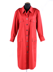 Ararat Gallery TAMA
TU, Melbourne, Dress coat
The Lady Barbara Grimwade Costume Collection is comprised of Lady Barbara Grimwade's personal apparel and includes 145 pieces of clothing, 10 hats, 19 handbags, 66 pairs of shoes and assorted accessories of gloves, belts and scarves. In its breadth, this significant acquisition ranges from the mundane to the memorable, therefore giving a balanced representation of one person's taste. Following Lady Barbara Grimwade’s death in March 1990, Ararat Gallery formally accepted the generous gift of clothing and accessories donated by Lady Grimwade's son, Mr Angus K Grimwade, on 28 August 1991. Subsequent smaller donations in 1995 enhanced the collection. Lady Grimwade's Scottish forebears, the Gaerloch Campbells, first settled in Australia in 1861 in the Ararat-Beaufort district. Her great great grandfather, Mr Henry Campbell, died on the voyage to Australia. His widow, Jane, with 10 of her 13 children, farmed and grazed land, firstly at Stockyard Hill then at Fiery Creek, near Buangor, before leaving the shire in 1873. Lady Grimwade held a privileged position in Melbourne society. As the wife of Sir Andrew Grimwade, a prominent businessman, Chairman of several boards and a Trustee of various committees, Lady Grimwade met with royalty, heads of state, politicians, corporate directors, and horse and cattle breeders. Excerpt from 'Hot Pink Summers' catalogue essay, Helen Jackson, 1995. -
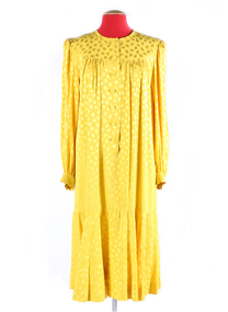 Ararat Gallery TAMA
TU, Melbourne, Dress
The Lady Barbara Grimwade Costume Collection is comprised of Lady Barbara Grimwade's personal apparel and includes 145 pieces of clothing, 10 hats, 19 handbags, 66 pairs of shoes and assorted accessories of gloves, belts and scarves. In its breadth, this significant acquisition ranges from the mundane to the memorable, therefore giving a balanced representation of one person's taste. Following Lady Barbara Grimwade’s death in March 1990, Ararat Gallery formally accepted the generous gift of clothing and accessories donated by Lady Grimwade's son, Mr Angus K Grimwade, on 28 August 1991. Subsequent smaller donations in 1995 enhanced the collection. Lady Grimwade's Scottish forebears, the Gaerloch Campbells, first settled in Australia in 1861 in the Ararat-Beaufort district. Her great great grandfather, Mr Henry Campbell, died on the voyage to Australia. His widow, Jane, with 10 of her 13 children, farmed and grazed land, firstly at Stockyard Hill then at Fiery Creek, near Buangor, before leaving the shire in 1873. Lady Grimwade held a privileged position in Melbourne society. As the wife of Sir Andrew Grimwade, a prominent businessman, Chairman of several boards and a Trustee of various committees, Lady Grimwade met with royalty, heads of state, politicians, corporate directors, and horse and cattle breeders. Excerpt from 'Hot Pink Summers' catalogue essay, Helen Jackson, 1995. -
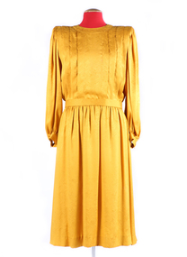 Ararat Gallery TAMA
TU, Melbourne, Dress with belt
The Lady Barbara Grimwade Costume Collection is comprised of Lady Barbara Grimwade's personal apparel and includes 145 pieces of clothing, 10 hats, 19 handbags, 66 pairs of shoes and assorted accessories of gloves, belts and scarves. In its breadth, this significant acquisition ranges from the mundane to the memorable, therefore giving a balanced representation of one person's taste. Following Lady Barbara Grimwade’s death in March 1990, Ararat Gallery formally accepted the generous gift of clothing and accessories donated by Lady Grimwade's son, Mr Angus K Grimwade, on 28 August 1991. Subsequent smaller donations in 1995 enhanced the collection. Lady Grimwade's Scottish forebears, the Gaerloch Campbells, first settled in Australia in 1861 in the Ararat-Beaufort district. Her great great grandfather, Mr Henry Campbell, died on the voyage to Australia. His widow, Jane, with 10 of her 13 children, farmed and grazed land, firstly at Stockyard Hill then at Fiery Creek, near Buangor, before leaving the shire in 1873. Lady Grimwade held a privileged position in Melbourne society. As the wife of Sir Andrew Grimwade, a prominent businessman, Chairman of several boards and a Trustee of various committees, Lady Grimwade met with royalty, heads of state, politicians, corporate directors, and horse and cattle breeders. Excerpt from 'Hot Pink Summers' catalogue essay, Helen Jackson, 1995. -
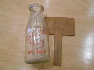 Surrey Hills Historical Society Collection
Domestic object - Wooden note, Note for the milk man
This note to the local milkman was associated with the milk bottle from the Wattle Park Dairy, which was purchased by Robin Kelly from a home in Surrey Hills in the 1970's or 1980's. This dairy was established by Horrie Breeden. The Breeden family came to Surrey Hills in 1905, first to Guildford Road, then Middlesex Road where Horrie Breeden lived as a boy. He sometimes used to help with milking at the adjoining Kenneally's dairy in Highfield Road. Sometimes he and his brother drove the cows from there to Schneider's property near Florence Road on the way to Surrey Hills Primary School. The cows would graze here until the boys took them back after school. At other times he would deliver milk from the Croydon Road dairy (Isherwood's or Bovill's) to St Joseph's Boys Home before school. Horrie became an apprentice in woodwork / carpentry at Vine's timber yard before serving in World War 1. Horrie's father died in 1919 and in the same year he bought 3 cows and established his own dairy on his mother's property on the corner of Goodwood Street and Boisdale Road. In the 1920s Horrie built the first house in Goodwood Street. He went on to build others in the street including his own at No 7 Goodwood Street. He did all the joinery and internal fittings for this. [Oral testimony: Horrie Breeden to Jocelyn Hall in 1979.] In the first half of the 20th century there were many local dairies in Surrey Hills and Mont Albert. In those days home deliveries were comparatively informal. This note to the milkman is material evidence of this. A rectangular wooden T-shaped note; the vertical part extending from middle of the lower edge and the upper part wide enough to balance on the top of a milk bottle.In grey lead pencil: " 1 pint / extra"dairies, milk delivery -
 Surrey Hills Historical Society Collection
Photograph, Grovedale Road Quarry in the 1920s - looking north, c1920
The quarry was part of John Butler Maling's property. He was one of the original settlers of the area and farmed the area between Weybridge Street and Whitehorse Road. Clay was quarried from part of this area and used to make the bricks used in the construction of his home, known as 'Ancyra'. This is still extant at the corner of Weybridge and James Streets. Maling grazed cows and used the quarry as a water source. He was the uncle of John Butler Maling, Mayor of Camberwell. He was married to Kate Conlon in 1882. They had 3 children: Silas Young, Alick and Zillah. Maling was born in c1829 in Shepreth, Cambridgeshire; he died in Surrey Hills on 9 October 1912 and is buried in Box Hill Cemetery - CE-*-0586. Mrs Kate Maling (born c1859 in Co Meath, Ireland) died at the property on 8 March 1921. She is buried in Brighton General Cemetery. Probate was valued at over 10,000 pounds and included other properties in Sandringham, Hawthorn and Macedon. At the time of her death the Surrey Hills property was described as being 23 cres with 2 brick houses, 1 cow, 2 heifers and 40 fowls or chickens. The property was subdivided after her death. The quarry was filled in after several drownings or near drownings and the land is now occupied by a park and playground maintained by the City of Boroondara. Beckett Park is sited on horizon to the left beyond the trees. This documents the landscape prior to close settlement and is material to early building and farming in the Surrey Hills area.Black and white photo of the quarry between Grovedale Road and James Street taken in the 1920s and looking north. In the foreground is an area of water with high banks dividing the horizontal centre. Beyond are paddocks and trees behind which is a row of at least 3 single-storey houses. Light poles can be seen along a distant street. There are many mature trees in the background. The houses and trees are positioned along Whitehorse Road in the vicinity of Westminster Street. Shadows indicate the photo was taken in early morning or evening.quarries, grovedale road, james street, surrey hills, balwyn, clay quarries, ancyra, kate conlon, kate maling, john butler maling, farming -
 National Wool Museum
Throw, 2017
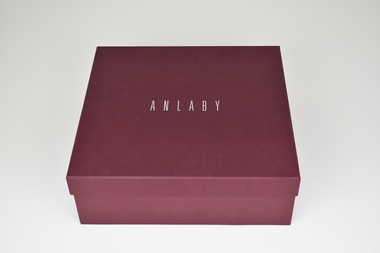
Anlaby’s sheep are born, bred and shorn at their farm located in South Australia. The wool is then scoured at Michels in Adelaide, combed and turned into Tops at Cashmere Connections in Bacchus Marsh, and then Spun and Woven at a historic mill in Scotland named Johnstons of Elgin. Sewing is completed by artisan seamstresses and packaging is from a local Adelaide family business. Established in 1839 just North of the Barossa Valley in South Australia, Anlaby is the oldest continuing merino sheep stud on mainland Australia. Fredrick Dutton employed Alexander Buchannan to bring sheep to the buoyant market in Adelaide from Goulburn NSW. Several others speculated on possible successes, including Buchannan and a flock of 18,000 sheep were walked overland. The trek took nine months. During this time the Adelaide market prices had collapsed. Having found land with a spring of sweet water, Dutton decided to keep his flock of 5,000 stud sheep and purchased a small parcel of land that is now called Anlaby. The property prospered and Buchannan was employed as manager for the next 25 years. At its height Anlaby covered 250sq miles – 160,000 acres and employed 70 men. The first bale of wool from South Australia to be auctioned in London came from Anlaby. The Anlaby stud also provided the foundation ewes for the well-known Bungaree merino stud in 1841. With prosperity came a large house and gardens for Buchannan in 1861. Anlaby was inherited by Henry Dutton from his uncle in 1895. Squire Dutton, as he was known, continued to grow the family’s fortunes and spent his money expanding the grand home and creating a magnificent 10-acre garden. Today the Anlaby merino stud continues and both the house and garden are undergoing significant restorations. Wool continues to be one of the most important elements at Anlaby. It was the source of great wealth in the past and is now directly tied into Anlaby’s future. Anlaby makes beautiful woollen scarves, lady’s wraps, exquisite throws and small range of baby blankets. From the moment a lamb is conceived and through its entire lifecycle Anlaby look after nutrition and quality of life. Twice a year the sheep are shorn and the wool using minimal treatment is washed, combed, spun and woven into the Anlaby product range. This attention to detail results in the buttery softness distinctive of the exclusive woollen range.Throw came with packaging and information card which reads ANLABY in large capital lettering at the top and bottom of either side of card. Throw is white with green edging of 15cm on two edges. Within this edging is the sewing of a tree in white.Wording: ANLABY Pure Anlaby Merino Wool Oldest merino stud on mainland Australia Made in Australia Card. Wording: ANLABY Certificate of Authentication THIS CERTIFICATE AUTHENTICATES THE PRODUCT TO BE 100% AUSTRALIAN AND MADE FROM PURE MERINO WOOL PRODUCED EXCLUSIVELY AT THE ANLABY MERINO STUD IN SOUTH AUSTRALIA THE ANLABY FLOCK (REGISTERED NUMBER 102) IS THE OLDEST CONTINUOSLY OPERATING MERINO STUD IN MAINLAND AUSTRALIA. THE MERINO FLOCK AT ANLABY MAINTAINS A GENETIC LINE STARTED IN 1839 THIS PRODUCT IS PART OF THE LIMMITED EDITION RANGE PRODUCED AT ANLABY. IN 2014 WE CELEBRATED ANLABY’S 175TH ANNIVERSAY ANLABY Reverse. Wording: ANLABY PURE NATURAL WOOL THE SHEEP GRAZE AMONGST THE GUM TREES ON THE ROLLING HILLS OF ANLABY. ANLABY SHEEP ARE CHARACTERISTICALLY BIG BODDIED AND BRED TO FLOURISH IN THE WARM AUSTRALIAN CLIMATE. OUR WOOL IS MINIMALLY TREATED AND THE PRODUCTS ARE MADE IN SMALL RUNS UNDER THE PERSONAL SUPERVISION OF THE OWNERS. WE BELIEVE IN SUSTAINABLE AND RESPONSIBLE FARMING AND MILLING PRACTICES. THE ATTENTION TO DETAIL RESULTS IN THE BUTTERY SOFTNESS DISTINCTIVE OF THIS EXCLUSIVE WOOLLEN PRODUCT. WITH CARE THIS IS A TREASURED ITEM FOR THE NEXT GENERATION. ANLABY www.anlaby.com.auwool, merino sheep, south australia, wool processing, wool processing textile finishing -
 Eltham District Historical Society Inc
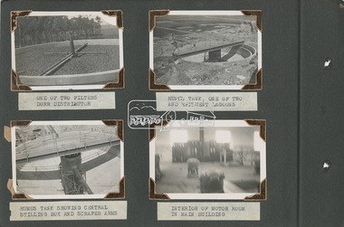
Album - Photograph Album, Alan Gardiner, M.M.B.W Braeside Sewage Treatment Plant Construction, 1939
In April 1928 the MMBW had the land and the plans for what they were to construct but the timing of the actual building did not proceed as planned. Before the construction could commence the Great Depression of the 1930s intervened forcing the shelving of its plans. The new owners then offered the land for lease resulting in Frederick Werrett taking the opportunity to take up the land he formerly owned to continue his market gardening activities of growing potatoes, onions and other crops. The land and improvements made by Syme were leased in 1929 to Harry Telford a trainer from New South Wales. Phar Lap grazed there for a short time. [9] However the population of Melbourne continued to grow and the need for a sewerage treatment plant did not go away. In 1939 when the effects of the Depression had dissipated work on the Sewerage Effluent Treatment Plant commenced and the following year in October the Premier of the State, Albert Dunstan, officially commissioned it. The Sewerage Effluent Treatment Plant at Braeside served the communities of south-east Melbourne for thirty five years until 1975. In that year all the sewers that entered the Braeside plant were diverted to the South Eastern Trunk Sewer complex at Carrum.[10] In 1982 the chairman of the MMBW at that time, Alan Croxford, announced that a substantial part of the property at Braeside would be administered by the Parks and Gardens section of MMBW as a public park. Subsequently the responsibilities were transferred to Parks Victoria, the situation that exists today. It is known as “Braeside Park” now. [Source: Sewerage Treatment Plant at Braeside, Kingston Local History, https://localhistory.kingston.vic.gov.au/articles/407]alan gardiner collection, 1939, braeside sewage treatment plant, construction, melbourne metropolitan board of works, mmbw -
 Eltham District Historical Society Inc
Album - Photograph Album, Alan Gardiner, M.M.B.W Braeside Sewage Treatment Plant Construction, 1939
In April 1928 the MMBW had the land and the plans for what they were to construct but the timing of the actual building did not proceed as planned. Before the construction could commence the Great Depression of the 1930s intervened forcing the shelving of its plans. The new owners then offered the land for lease resulting in Frederick Werrett taking the opportunity to take up the land he formerly owned to continue his market gardening activities of growing potatoes, onions and other crops. The land and improvements made by Syme were leased in 1929 to Harry Telford a trainer from New South Wales. Phar Lap grazed there for a short time. [9] However the population of Melbourne continued to grow and the need for a sewerage treatment plant did not go away. In 1939 when the effects of the Depression had dissipated work on the Sewerage Effluent Treatment Plant commenced and the following year in October the Premier of the State, Albert Dunstan, officially commissioned it. The Sewerage Effluent Treatment Plant at Braeside served the communities of south-east Melbourne for thirty five years until 1975. In that year all the sewers that entered the Braeside plant were diverted to the South Eastern Trunk Sewer complex at Carrum.[10] In 1982 the chairman of the MMBW at that time, Alan Croxford, announced that a substantial part of the property at Braeside would be administered by the Parks and Gardens section of MMBW as a public park. Subsequently the responsibilities were transferred to Parks Victoria, the situation that exists today. It is known as “Braeside Park” now. [Source: Sewerage Treatment Plant at Braeside, Kingston Local History, https://localhistory.kingston.vic.gov.au/articles/407]alan gardiner collection, 1939, braeside sewage treatment plant, construction, melbourne metropolitan board of works, mmbw -
 Flagstaff Hill Maritime Museum and Village
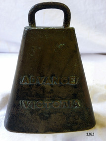
Functional object - Cow Bell, Early 20th century
Research is still being carried out regarding the inscription on this bell. Perhaps it was used for horses during the war. It may have been a souvenir or perhaps just a political statement, similar to 'Buy Australian'. Cow bells were common to colonial agriculture and transport, used wherever animals were turned out to graze overnight and had to be rounded up again next morning. Bells were fastened around the necks of household milking cows, domestic goats, bullock teams, horse teams, and camel teams, to help find them in the pre-dawn light. Station shepherds and cattle drovers also used them to warn of any disturbances to their flocks and herds overnight. The bells were a necessary item in a largely unfenced continent. So important, that Anthony Mongon began making his pot-bells at Yackandandah from 1861, August Menneke produced the “Wagga Pot” from 1867, and Samuel Jones started manufacturing his distinctively shaped “Condamine Bell” in 1868. However, these deeply resonant Australian bells were made from iron — Mongon and Jones were blacksmiths who simply beat old pitsaw blades into shape. Few genuinely brass cow bells were made here, the vast majority being imported from Britain where the industry of brass founding was already well established. (Some bells were also imported from the United States, but these too were nearly all of iron).This bell is historically significant as typical of a cow bell used by farmers and herdsmen in Colonial Victoria. Cow bell, brass, topless pyramid shape, inverted "U" shaped pin attached. Pin and clapper are iron. Bell is embossed on sides. Embossed "ADVANCE / VICTORIA" and "WWI"flagstaff hill, warrnambool, shipwreck coast, flagstaff hill maritime museum, flagstaff hill maritime village, maritime museum, great ocean road, cow bell, horse bell, bell smith, vintage bell, farmer, shepherd, drover, stock bell, brass bell, advance australia, wwi -
 Whitehorse Historical Society Inc.
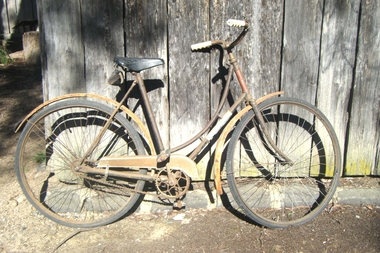
Vehicle - Bicycle
In 1914, Mr and Mrs Arthur Hooke gave the name ‘Wandinong’ to their newly purchased property in Blackburn. The name was inspired by a recent cycling trip to Wandin in the foothills of the Dandenongs, as well as the title of a favourite book, Ethel Turner’s ‘The Camp at Wandinong’. Their property and the surrounding district had originally been owned by a series of property investors and speculators, and while some of it had been cleared for grazing, most of it was still covered in virgin bush; thickly covered with trees and undergrowth and rich in wild flowers and bird life. A small section of the Hooke’s property was cleared sufficiently to r\erect a house and some outbuildings, but the rest was left as n nature intended. Mar Arthur Hooke was a local property valuer but never owned a car, preferring to attend to business on his bicycle. He was still riding his bicycle in his eighties. Meanwhile, Mrs Hooke had developed a keen desire that the ‘Wandinong’ property remain intact; that it should ultimately be set aside as a place of refuge where like-minded people could go to enjoy peace and quiet amongst the native birds and bushland.|To this end, Mr and Mrs Hooke liaised with the Nunawading Council and an agreement was reached whereby the council would assume ownership of the property on their deaths. When Mr Hooke died in 1972, his wife transferred the land over to the council the following year. Mr and Mrs Arthur Hooke’s Grandson, William, and granddaughter, Christine, recently donated their grandmother’s bicycle to the Whitehorse Historical Society. They recall that their grandfather’s bicycle was given to a representative of the Nunawading Council for safekeeping some years ago. Ladies two wheel bicycle with tool bag attached & black leather seat. Two mud guards, a skirt guard & a reflector on the back mud guard. 'Kew Flyer' painted on front mud guard. Two rubber tyres & provision for a head light on the handle bars.'Kew Flyer'transport, bicycles -
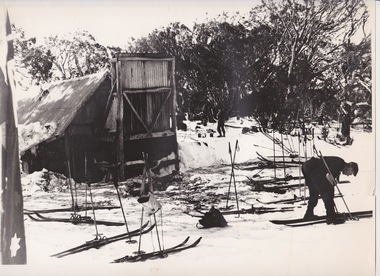 Falls Creek Historical Society
Photograph - At Wallace' s Hut
Wallace's Hut is the oldest surviving cattlemen's hut on the High Plains, built in 1889 by the three Wallace brothers - Arthur, William and Stewart. Their father David bought land at Kergunyah as well as grazing land on the banks of the Kiewa River, North East Victoria. Once the boys were old enough, the family followed the local squatters’ custom of taking their cattle up to the mountains for the spring and summer to fatten the mob, at the same time resting their home pastures. They decided to build a hut where they could shelter from the extreme mountain weather. The timber was cut from the forest about four hundred metres east of the hut, and the hearth stone was dragged in from Pretty Valley. The chimney had a base of rubble and above this iron sheeting on a timber frame. The slab walls were lined with hessian and later with tar-paper, and inside there was a bush table, sleeping platform and a rustic fire-side settle. The hut nestled among snow gums sheltered by a rocky outcrop. The names of the Wallace brothers were burnt into the tie-beams of the roof and at the back of the mantelpiece. The Wallace family’s lease expired in the late 1930s and the hut was bought by the State Electricity Commission to house staff on the High Plains and it became the first home of Toni and Skippy St. Elmo. The SEC covered the old shingles with iron, and later on the walls and chimney as well, and they added a lean-to. Wallace’s Hut is now owned by the Crown and maintained by Parks Victoria. It is on the Historic Buildings Register and is classified by the National Trust.This image is significant because it depicts an important heritage-listed structure and refuge for cattlemen and other travellers in Victoria's High Country.A black and white photograph of a skier outside of Wallace's Hut. Several sets of skis and poles are standing around and other skiers are in the background.wallace's hut, toni and skippy st. elmo, high country huts -
 The Beechworth Burke Museum
Geological specimen - Olivine Crystals, Unknown
Olivine is mostly found on the Earth's surface in igneous rocks that are dark-coloured. It is common at divergent plate boundaries and at warm spots, such as volcanic areas. It crystalises and forms during the cooling of magma. Olivine is used in refractory sand, bricks, and gemstones. Olivine has been found on a number of meteorites, which might have originated from large asteroids or the mantle of a now-destroyed planet. This olivine crystal is thought to originate from Mount Noorat, with speculation that it could have originated from Mount Shadwell. Mount Noorat is a dormant volcano cone located in the Newer Volcanics Province of Victoria. Mount Noorat belongs to the Kirrae Wuurong people, who used the Mount as a place for meetings and gatherings prior to European settlement. Contact was first made between European settlers and the Indigenous people in 1841. The Mount has mostly been used for cattle and sheep grazing. Mount Shadwell is a well-known source of olivine and is the highest of a gathering of volcanic cones. The New Volcanic Province is located in South East Australia and covers 15000 square kilometres. It contains 400 explosive vents and small shield volcanoes. The last eruption is thought to have occurred 5000 years ago at Mount Gambier and Mount Schank. This olivine crystal has been identified as a volcanic bomb, which is a molten rock which was pushed out and ejected into the air when a volcano reupts. A rock needs to be larger than 65 mm in diameter to be classified as a volcanic bomb. This olivine volcanic bomb and its locality is historically and socially significant. The olivine was found in the Newer Volcanic Province, an area which contains over 400 dormant volcanoes. This olivine is one part of a volcanic bomb, which would have ejected when magma erupted out of a volcano. This specimen is part of a larger collection of geological and mineral specimens collected from around Australia (and some parts of the world) and donated to the Burke Museum between 1868-1880. A large percentage of these specimens were collected in Victoria as part of the Geological Survey of Victoria that begun in 1852 (in response to the Gold Rush) to study and map the geology of Victoria. Collecting geological specimens was an important part of mapping and understanding the scientific makeup of the earth. Many of these specimens were sent to research and collecting organisations across Australia, including the Burke Museum, to educate and encourage further study.A solid iron-magnesium silicate mineral with shades of green and brownburke museum, beechworth, geological, geological specimen, olivine, igneous rock, volcanic, gemstones, volcanic bomb, meteorites, asteroids, plantes, mount noorat, mount shadwell, indigenous, kirrae wuurong people, newer volcanics province, victoria, european settlement, eruption -
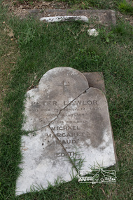 Eltham District Historical Society Inc
Photograph, Peter Pidgeon, Grave of Peter Lawlor and children, Eltham Cemetery, Victoria, 5 April 2021
The Victorian gold rush came to Eltham in the early 1850s and with it came a crime wave. Local traders called for police protection. This led to the appointment in 1857 of Irish-born Peter Lawlor as Senior Constable at Eltham. In 1859 Peter and his wife Kate were able to move into an official police residence at the corner of Maria Street (now Main Road) and Brougham Street, with stables out the back and a large paddock for grazing across the road. Some of their children went to Eltham Primary School. That 1859 police residence is now the home of the Eltham District Historical Society. The small wooden building on the very corner is a modern replica of the separate police station/office built around 1885-1900. Cases investigated by Constable Lawlor included murders, stealing (horses, cattle, fowls, watches, linen, clothing), a search for a missing person, and two separate instances of abandoned children seeking help. He was officially commended in 1866 for bringing to justice a man who had indecently assaulted an 11-year old girl. Sadly, there was a similar but unconnected case only a few months later. But events had a lighter side; in 1871 Kate lent her piano to the Snowflakes Christy Minstrels for a Catholic Church fund-raising concert. Peter was transferred to Prahran in 1872. He died in 1876 and is buried in Eltham Cemetery with four of his children. His headstone was stolen some time after May 1990 but was returned anonymously (broken into three pieces) in August 2013. It is resting on his grave but has not been re-erected. The Inscription reads: Peter Lawlor Who died February 12th 1876 Aged 55 years Also his children Michael Margaret Maud and EdithBorn Digitaleltham cemetery, gravestones, edith lawlor, margaret lawlor, maud lawlor, michael lawlor, peter lawlor -
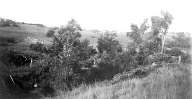 Surrey Hills Historical Society Collection
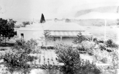
Photograph, View from Goodwood Street, Surrey Hills in 1930, 1930
The Breeden family came to Surrey Hills in 1905, first to Guildford Road, then Middlesex Road where Horrie Breeden lived as a boy. He sometimes used to help with milking at the adjoining Kenneally's dairy in Highfield Road. Sometimes he and his brother drove the cows from there to Schneider's property near Florence Road on the way to Surrey Hills Primary School. The cows would graze here until the boys took them back after school. At other times he would deliver milk from the Croydon Road dairy (Isherwood's or Bovill's) to St Joseph's Boys Home before school. Horrie became an apprentice in woodwork / carpentry at Vine's timber yard before serving in World War 1. Horrie's father died in 1919 and in the same year he bought 3 cows and established his own dairy on his mother's property on the corner of Goodwood Street and Boisdale Road. In the 1920s Horrie built the first house in Goodwood Street. He went on to build others in the street including his own at No 7 Goodwood Street. He did all the joinery and internal fittings for this. [REF: Oral testimony: Horrie Breeden to Jocelyn Hall in 1979.] In the 1990s the owner of 7 Goodwood Street discovered a branding iron under the house; this is presumed to relate to Horrie Breeden's dairy. It was donated to SHNC's collection. Horrace Bruce Breeden (7 July 1898-24 January 1988) was son of Charles Henry Breeden and Lavinia Maria Darby, both born Warwickshire; buried in Box Hill Cemetery. He was one of a large family. He married Olive Mary Romey.Black and white photo taken from the east end of Goodwood Street, Surrey Hills in 1930, looking towards Elgar and Riversdale Roads. It shows an area which is rural in appearance. It is not built upon. The foreground is grassy and there is a post-and-wire fence to the right. There is a bank of eucalyptus trees behind which is hilly grassland.goodwood street, dairies, horace breeden, horrie breeden -
 Eltham District Historical Society Inc
Photograph - Digital Photograph, Alan King, Alistair Knox Park, Eltham, 2008
Alistair Knox Park, an oasis of peace and beauty. Covered under National Trust of Australia (Victoria) Landscape Significance and Heritage Overlay, Nillumbik Planning Scheme. Published: Nillumbik Now and Then / Marguerite Marshall 2008; photographs Alan King with Marguerite Marshall.; p173 It is hard to imagine that the Alistair Knox Park, an oasis of peace and beauty beside busy Main Road, Eltham, was once the township’s rubbish dump. It was only in the 1970s that the tip was transformed into this beautiful six hectare space, which later earned it a National Trust Landscape classification. Before its life as a dump, the area was used for small farms. Thanks largely to the foresight and efforts of local environmental builder Alistair Knox, the park was designed sympathetically with the character of the wider Eltham landscape. Then, appropriately, the park was named after Knox, who was an Eltham Shire Councillor from 1971 to 1975 and Shire President in 1975. The park designers were four major forces in the urban bush landscape garden –Knox, landscape designer Gordon Ford, artist Peter Glass and landscaper Ivan Stranger.1 The National Trust citation for the park, originally called Eltham Town Park, includes the Eltham railway trestle bridge and the Shillinglaw Cottage. The citation states ‘the semi-natural setting of the parkland provides a landscape which is evocative of the history of the area’. Manna Gums (Eucalyptus viminalis) and Candlebarks (Eucalyptus rubida) are significant features. Most of the park’s construction was directed by Bob Grant, Superintendent of the Parks and Gardens Department for the Eltham Shire Council. First plantings occurred in Arbour Week in 1973, then the lake and botanic area were completed in 1975, with Federal Government funding, and the toilet block in 1978. Bounded by the Eltham railway line, Panther Place, Main Road, Bridge and Susan Streets, the park is in a valley about a kilometre wide overlooked by steep hills at the east and west. The Diamond Creek flows through it and the picturesque historic timber trestle railway bridge edges the north. Informal plantings of Australian indigenous and native species in open and undulating grassed settings blend with the natural landscape of the Diamond Creek to the west. The bush-style plants, particularly around the creek, balance with open lawns, paths and a cascade flowing from a small lake to another below. A footbridge over the creek leads to the park’s west. The park includes an adventure playground and barbecue areas. The park stands on part of the land bought from the Crown in 1851 by Josiah Holloway, who subdivided it into allotments and which he called Little Eltham. Most of the land was subdivided into residential lots, but the creek valley, on which the park stands, was subdivided into farm-size lots, used mainly for orchards and grazing. One of the earliest owners was John Hicks Petty, who in 1874 bought a plot from Holloway. Other families who owned properties in that area, included Rees, Clark, Waterfall, Graham, Hill and Morant.2 In 1901 the railway was built through the area. Jock Read, an Eltham resident since around 1920, remembers several farms in the 1920s and ’30s that occupied the site of today’s park. A poultry farm, which extended from present day Panther Place, was owned by the Gahan family. Next to that farm was another for grazing cattle owned by Jack Carrucan. Beside this was land owned by John Lyon. A doctor lived beside this, and at the north-west corner of Bridge Street and Main Road stood a memorial to the soldiers who died in World War One, which was later moved to the RSL site. Mr Read also remembers other farms and orchards west of the creek In the early 1960s the Eltham Council began buying these farms and in the late 1960s turned the areas east of the Diamond Creek into a garbage tip. When this was filled above the creek’s flood plain, the tip was moved to the west of the creek.This collection of almost 130 photos about places and people within the Shire of Nillumbik, an urban and rural municipality in Melbourne's north, contributes to an understanding of the history of the Shire. Published in 2008 immediately prior to the Black Saturday bushfires of February 7, 2009, it documents sites that were impacted, and in some cases destroyed by the fires. It includes photographs taken especially for the publication, creating a unique time capsule representing the Shire in the early 21st century. It remains the most recent comprehenesive publication devoted to the Shire's history connecting local residents to the past. nillumbik now and then (marshall-king) collection, alistair knox park, eltham -
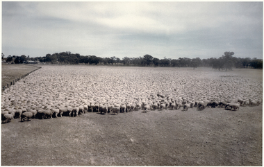 National Wool Museum
Photograph, Puckapunyal - 75,172 Sheep for Shearing, 1988
Banjo Paterson once wrote, ‘The musterers are fetching them a hundred thousand strong’. Well, not quite 100,000 strong, but there are 75,172 mixed age Riverina-bred merino wethers in this mob mustered for shearing on January 22, 1988. The sheep were owned by the Mountjoy family from Geelong Victoria and were running on Puckapunyal Army Base near Seymour in Central Victoria on which the family held the grazing lease. Contractor for the shearing, Jim Walker, Avenel, Victoria, former Australian shearing team captain in 1974-75 and 1978-79, recalls there were up to 21 shearers in his team waiting for the red eyes to arrive despite the mid-summer heat of up to 38°C and the blinding dust on windy days. Jim Walker thinks there may also have been some sheep in the mob from Portland Downs and Isis Downs near Isisford in Central Queensland. The biggest shearing he did at ‘Pucka’ was 87,087 shorn in 1988. The ‘Pucka’ base was established during WW1. During the Second World War the Second Australian Imperial Force trained there as well as the US Army 41st Infantry Division. It was also home to the 1st Armoured Regiment from 1949 until 1995. During the 1950s up to 4000 national servicemen at any given time were training there. In the 1980s the Army undertook a major 60,000-acre land rehabilitation programme as decades of heavy use had led to serious degradation. By 1988 when the photo was taken, further land acquisition had increased the area to just under 100,000 acres, 43,000 of which is still bush country. There are no sheep there now, and the old shed was bulldozed and burnt. There are thousands of kangaroos which of course don’t need to be shorn and would be hard to muster and hold for a similar photo. Colour photograph, 75,172 merino wethers, mustered for shearing at Puckapunyal in 1988.shearing merino sheep, mountjoy, mr dale - worungalla pastoral co., shearing, merino sheep -
 Surrey Hills Historical Society Collection
Photograph, Grovedale Road Quarry in the 1920s - looking south, c1920
The quarry was part of John Butler Maling's property. He was one of the original settlers of the area and farmed the area between Weybridge Street and Whitehorse Road. Clay was quarried from part of this area and used to make the bricks used in the construction of his home, known as 'Ancyra'. This is still extant at the corner of Weybridge and James Streets. Maling grazed cows and used the quarry as a water source. He was the uncle of John Butler Maling, Mayor of Camberwell. He was married to Kate Conlon in 1882. They had 3 children: Silas Young, Alick and Zillah. Maling was born in c1829 in Shepreth, Cambridgeshire; he died in Surrey Hills on 9 October 1912 and is buried in Box Hill Cemetery - CE-*-0586. Mrs Kate Maling (born c1859 in Co Meath, Ireland) died at the property on 8 March 1921. She is buried in Brighton General Cemetery. Probate was valued at over 10,000 pounds and included other properties in Sandringham, Hawthorn and Macedon. At the time of her death the Surrey Hills property was described as being 23 acres with 2 brick houses, 1 cow, 2 heifers and 40 fowls or chickens. The property was subdivided after her death. The property was subdivided into 110 house blocks in c1923 - see Maling's Estate subdivision flyer on the State Library of Victoria's website. This shows that the Grovedale Park site had been acquired by Camberwell Council by this time. An attached newspaper clipping documents prices realised for a cross-section of blocks. The MMBW map of 1925, also on the SLV website, shows the outline of the clayhole / quarry. The quarry was filled in after several drownings or near drownings and the land is now occupied by a park and playground, known as Grovedale Road Park, maintained by the City of Boroondara. Beckett Park is sited on horizon to the left beyond the trees. This documents the landscape prior to close settlement and is material to early building and farming in the Surrey Hills area.Black and white photo of the quarry between Grovedale Road and James Street taken in the 1920s and looking south. In the foreground is an area of water with reeds in the LH corner. Beyond on the high banks there are single storey houses in the background and (?) some light poles. An object that looks like a tank on posts is in a cutting on the far bank.quarries, grovedale road, james street, clay quarries, farming, kate conlon, kate maling, john butler maling, ancyra -
 Surrey Hills Historical Society Collection
Photograph, 'Glenisla', 18 Chestnut Street, Surrey Hills, c 1920, 1920
Date is approximate. In 1920 this became the home of Mr and Mrs Robert Moore, whose daughter Mabel Annie married Norman Brodley Carter of Mont Albert. The house was named after 'Glenisla', a western District grazing property located between Hamilton and Horsham on the Henty Highway and on the edge of the Grampians National Park. This was established as a super-fine wool stud in 1860 and was passed down the family until it was sold in 1922. The family transferred from this property to Melbourne. Robert is listed as a grazier in the 1924 electoral roll at Chestnut Street. With him are Victor Cecil listed as a carpenter; Isabella, Mabel Annie and Edgar Gilbert listed as an orchardist. In 2003 the house was extant minus the verandas. This photo may have been taken from the rear of the property. Ref: History of original property - Age newspaper article: 'The Best - Glenisla: historic Grampians property', 7 January 1994. Moore family details: Robert Moore born 1857 on Isle of Man; died Surrey Hills 1940 Isabella Bateson born 1869; died Surrey Hills 1938 Married in 1894 in Miram, 10 km north-east of Kaniva in the northern Wimmera. All the children were born in Kaniva. Children: Lena Florence (1895-1980) Victor Cecil (1896-1984) - a builder Edgar Gilbert (1897-1976); died Surrey Hills; married Myrtle Emary, daughter of Henry John Emary of Surrey Hills Ernest Alan (1900-1900) Mabel Annie (1901-1957); died Surrey Hills married Norman Brodley Carter (1899-1984) Clarence Arthur (1904-2004). Norman Carter took many photos in the Surrey Hills and Mont Albert are from the 1920s; many is connection with Church of England events and activities. Robert and Isabella Moore are buried in Box Hill Cemetery. Black and white photo of a Victorian home with a veranda with a corrugated iron roof and lacework on 2 sides. It appears to have a later extension at the rear. It is surrounded by mature gardens with ornamental trees (cypresses) and an area with plants in rows, which may be a vegetable garden. There appears to be significant areas of open space around the house.glenisla, homes, victorian style, gardens, norman carter, robert moore, miss isabella bateson, mrs isabella moore, victor cecil moore, edgar gilbert moore, miss mabel annie moore, box hill cemetery -
 Eltham District Historical Society Inc
Photograph - Digital Photograph, Alan King, Blue Lake, Plenty Gorge Park, 2008
A quarry was transformed into the Blue Lake. Published: Nillumbik Now and Then / Marguerite Marshall 2008; photographs Alan King with Marguerite Marshall.; p179 The dramatic steep-sided Plenty Gorge lies along the divide of two geological areas, and separates the Nillumbik Shire and the City of Whittlesea. On the Nillumbik side are undulating hills and sedimentary rock, and in Whittlesea, lies a basalt plain formed by volcanic action up to two million years ago. This provides the Plenty Gorge Park with diverse vegetation and habitats, making it one of Greater Melbourne’s most important refuges for threatened and significant species. The park, established in 1986, consists of around 1350 hectares, and extends 11 kilometres along the Plenty River, from Greensborough to Mernda. It provides a wildlife corridor for around 500 native plant and 280 animal species.1 The area’s plentiful food and water attracted the Wurundjeri Aboriginal people and then European settlers. By 1837 squatters had claimed large runs of land for their sheep and cattle. The Plenty Valley was among the first in the Port Phillip District to be settled - mainly in the less heavily timbered west - and was proclaimed a settled district in 1841.2 But by the late 1880s, the settlers’ extensive land clearing for animal grazing, then agriculture, depleted the Wurundjeri’s traditional food sources, which helped to drive them away. Many Wurundjeri artefacts remain (now government protected), and so far 57 sites have been identified in the park, including scarred trees, burial areas and stone artefacts. Pioneer life could be very hard because of isolation, flooding, bushfires and bushrangers. Following the Black Thursday bushfires of 1851, basalt was quarried to build more fire-resistant homes. Gold discoveries in the early 1850s swelled the population, particularly around Smugglers Gully; but food production made more of an impact. In the late 1850s wheat production supplanted grazing. In the 1860s the government made small holdings available to poorer settlers. These had the greatest effect on the district, particularly in Doreen and Yarrambat, where orchards were established from the 1880s to 1914. Links with a prominent early family are the remains of Stuchbery Farm, by the river’s edge bounded by Smugglers Gully to the north and La Trobe Road, Yarrambat, to the east. The Stuchberys moved to the valley in 1890, and the family still lives in the area. In 1890, Alfred and Ada first lived in a tent where four children were born, then Alfred built the house and outbuildings around 1896. They planted an orchard, then a market garden, and developed a dairy. The family belonged to the local Methodist and tennis communities. Their grandson Walter, opened the Flying Scotsman Model Railway Museum in Yarrambat, which his widow, Vi, continues to run. Wal was also the Yarrambat CFA Captain for 22 years until 1987. Walter sold 24 hectares in 1976 for development - now Vista Court - and in 1990, the remaining 22.6 hectares for the park. Remaining are an early stone dairy and remnants of a stone barn, a pig sty and a well.3 Until it was destroyed by fire in 2003, a slab hut stood on the Happy Hollow Farm site, at the southern end of the park. The hut is thought to have been built in the Depression around 1893. This was a rare and late example of a slab hut with a domestic orchard close to Melbourne. Emmet Watmough and his family first occupied the hut, followed by a succession of families, until the Bell family bought it around 1948. There they led a subsistence lifestyle for 50 years, despite encroaching Melbourne suburbia.4 The Yellow Gum Recreation Area includes the Blue Lake, coloured turquoise at certain times of the year. Following the 1957 bushfires, this area was quarried by Reid Quarries Pty Ltd for Melbourne’s first skyscrapers, then by Boral Australia. However in the early 1970s water began seeping into the quarry forming the Blue Lake and the quarry was closed. The State Government bought the site in 1997 and opened it as a park in 1999.This collection of almost 130 photos about places and people within the Shire of Nillumbik, an urban and rural municipality in Melbourne's north, contributes to an understanding of the history of the Shire. Published in 2008 immediately prior to the Black Saturday bushfires of February 7, 2009, it documents sites that were impacted, and in some cases destroyed by the fires. It includes photographs taken especially for the publication, creating a unique time capsule representing the Shire in the early 21st century. It remains the most recent comprehenesive publication devoted to the Shire's history connecting local residents to the past. nillumbik now and then (marshall-king) collection, blue lake, plenty gorge park -
 The Beechworth Burke Museum
Postcard
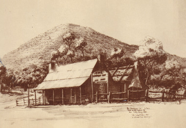
This Australian yesteryear postcard was published by Cobb & Co in circa 1990. It is a sepia toned artwork of the Ann Jones Inn in Glenrowan which was taken prior to 1880. The building at rear in this photograph was the private residence of Ann Jones, a migrant from Tipperary, Ireland. Two years after building her private residence, in 1878/1879, Ann Jones added the Inn to the front of the building which is depicted in the postcard. In 1880 the Inn was burned to the ground during the Kelly Gang siege. After the siege, Ann Jones and her children continued to live on the same location in a makeshift hut. This hut was later replaced with a dwelling using compensation money provided to Ann from the government for the loss of her property and goods; however, she was denied a new trading licence which did not enable her to re-establish her previously successful business. The reverse of this postcard provides a snippet of information into the Glenrowan siege, for which this site is most well-known. It outlines the role and demise of the members of the Kelly Gang but what it does not include is how Ann Jones, owner of the Inn depicted on the postcard, was impacted. Ann’s son of 13 years, Johnny was killed during the siege, and a bullet grazed the forehead of her daughter, Jane Jones. Jane would die two years after this event from tuberculosis, but it was believed by Ann that the cause was grief for the death of her brother and distress at having witnessed the siege. Ann was provided with 100 pounds in compensation money for the loss of her children. Her husband, Owen Jones passed away late 1880 and in 1891 Ann Jones remarried. She died at the age of 80 in 1910. The “last stand” of the Kelly Gang at this location is estimated by Dr Stuart Dawson of Monash University to have taken less than 10 minutes in duration. During and following this time, the life of Ann Jones was turned upside down and everything she had worked for in the preceding years was now in ruins. This postcard has the capacity to reveal information about the popularity of the Kelly story in Australia. It was created in approximately the 1990s which perhaps reveals a resurgence in interest into the Kelly Gang and Australian history when card was made. This image, and others depicting the Ann Jone’s Inn, have the ability to shed light on the Kelly story and the events of the Glenrowan Siege. Additionally, they can reveal information into the life of a female business owner during the 1870-1880 period. Archaeological research has been conducted at this site by LaTrobe University and a study of these images alongside the analysis of the material culture found at this location can help to build more comprehensive understanding into life in Australia during this period and Ann Jones herself.Sepia rectangular postcard printed on cardObverse: [Illegible] Reverse: G4/ 3276/ Australian / Yesteryear / cards/ correspondence / address / Published by Cobb & Co (03) 5766 2409 / The Glenrowan Inn owned by Ann Jones. / It was this Inn in which the Kelly Gang imprisoned / 62 people, while waiting for the special train / carrying the police to arrive from Benalla. On 28th / June 1880, following a seige which lasted over 12 / hours, Ned Kelly was captured. Joe Byrne was shot, / and the Inn was set on fire in an attempt to flush out / the two remaining outlaws, Dan Kelly and Steve / Hart. However, some time prior, the two boys, it / was believed, had committed suicide, as a result, / their bodies were incinerated beyond recognition. / A sepia tone facsimile of / an early Australian photograph. /kelly album, postcard, glenrowan inn, kelly siege, australia yesteryear card, cobb & co publisher, ned kelly capture, jones ann, dan kelly, joe byrne, steve hart, fire, train, police, benalla, 28 june 1880 -
 Flagstaff Hill Maritime Museum and Village
Functional object - Cow Bell, Circa 1878
The artefact is a brass cow bell recovered from the 1878 shipwreck of the LOCH ARD near Port Campbell. It was raised by Flagstaff Hill divers in 1973 and is in storage at the Maritime Village. A cow bell is a bell worn around the neck of free-roaming livestock so herders can keep track of an animal via the sound of the bell when the animal is grazing out of view in hilly landscapes. Although they are typically referred to as "cow bells" due to their extensive use with cattle, the bells are used on a wide variety of animals. The earliest examples of truly recognizable cow bells date back to the Iron Age. The use of iron bells in sub-Saharan African music and the Niger–Congo area is linked to the early iron-making technology spread during the Bantu migrations. The earliest archaeological evidence of bells dates back to more than 5000 years ago, from the 3rd millennium BC in Neolithic China. During this era, there is evidence of early forms of pottery cow bells, which were likely used to keep track of goats, sheep, and cattle. These pottery bells were later replaced by metal bells using brass and other materials. The LOCH ARD was constructed on the Clyde in 1873 for the prestigious Loch Line of colonial clipper ships, designed for the Australian run. She sailed from England on 1 March 1878 carrying 37 crew, 17 passengers and a diverse general cargo ranging from luxury items to bulk railway iron. On 1 June 1878, emerging from fog and hearing too late the sound of breakers against the tall limestone cliffs, the vessel struck the southern foot of Mutton Bird Island and sank in 23 metres of water. Of the fifty-four people on board only two survived, one young male crewman, Tom Pearce, and one young female passenger, Eva Carmichael. (See References or Notes below for further details.)The cow bell is believed to be part of the cargo of the Loch Ard and this shipwreck of the Loch Ard is of historical significance for Victoria. Registered on the Victorian Heritage Register ( S 417), with Flagstaff Hill having a varied collection of artefacts from the Loch Ard. Its collection is significant for being one of the largest accumulation of artefacts from this notable Victorian shipwreck. The collections object is to also give us a snapshot into history so we can interpret the story of this tragic event. The collection is also archaeologically significant as it represents aspects of Victoria's shipping history that allows us to interpret Victoria's social and historical themes of the time. The collections historically significance is that it is associated unfortunately with the worst and best-known shipwreck in Victoria's history. Brass cow bell, covered in encrustations. flagstaff hill, warrnambool, shipwreck coast, flagstaff hill maritime museum, flagstaff hill maritime village, maritime museum, great ocean road, shipwreck artefact, loch ard, mutton bird island, glenample, eva carmichael, tom pearce, flagstaff hill divers, cow bell, horse bell, bell smith, vintage bell, farmer, shepherd, drover, stock bell, brass bell -
 Wooragee Landcare Group
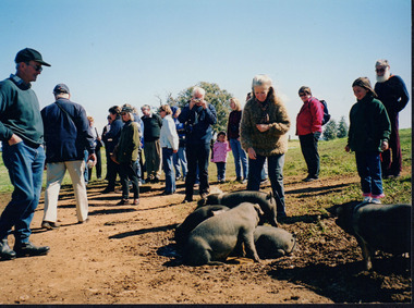
Photograph, 5 September 2004
This photograph was taken at Samaria Farm on Sunday the 5th of September when Wooragee Landcare Group took a bus trip to the Tatong area (near Benalla) to look at land use on small farms. The day trip was organised to observe land use on small farms as well as a social event for the Group. Samaria Farm at the time was a nine-hectare property located in northeast Victoria, near Mount Samaria, 130 km Northeast of Melbourne. The photograph features several pigs believed to be the breed called Large Black. The Large Black Pig breed is a traditional, heritage breed that was first imported to Australia from the UK in the early 1900's. It is believed to have originated from the Old English Hog of the 16th and 17th Centuries. The first reference to them in the Australian Pure Bred Pig Herd Book was in 1912. They are a black pig with lop ears and were prized for their superior milking and mothering abilities and soon became popular with early Dairy Farmers who fed them whey from separated milk as part of their butter making process. They proved economical to keep and, being excellent grazing pigs, were also used to pick up windfall fruit in orchards. Their black colouring also enabled them to withstand the hot Australian summers and avoid sunburn which combined with their hardiness and docile temperament made them highly suitable for free-range pork production, however Large Black pigs tend to get very fat and were not suitable for intensive farming so were often crossed with other breeds for pork production. They are now quite rare as a pure breed having been on the edge of extinction for some time. They were rescued in the early 1990s by a rare breeds farmer in the Yarra Ranges. These days they are also the focus of a small conversation effort with six registered breeders currently in Australia. For biosecurity reasons there are no imports of live pigs or pig semen permitted into Australia. This photograph shows a group of people attending one of the events that Wooragee Landcare Group has organized within the educational framework of promoting best land management practices for all types of land uses and ensuring sustainability, in addition to encouraging community interaction via social events. The Large Black pig breed is significant because of their role in early Victorian farming. They are now quite rare as a pure breed having been on the edge of extinction for some time. These days they are the focus of a small conversation effort with six registered breeders currently in Australia. For biosecurity reasons there are no imports of live pigs or pig semen permitted into Australia. Wooragee Landcare Group is important to local community landcare and environmental management practices.Colour rectangular photograph printed on paperObverse: WAN NA EONA2N2. ANN+ 3 4240/ (No. 17) 370samaria farm, wooragee landcare, wooragee landcare group, tatong, benalla, black pigs, large black, traditional breed, heritage breed, pigs, lop ears, free range pork production, early victorian farming -
 Federation University Historical Collection
Document - Reports, Martin Westbrooke, Nanya Station
Nanya Station, owned and managed by the University of Ballarat (now Federation University Australia), was purchased with assistance from the Department of Environment and Heritage Government Caring for our Country program. Nanya Station is located in the Scotia country, west of the Darling Ana-Branch in far western New South Wales and consists of the Nanya Western Lands Pastoral Lease 3281 – Perpetual Leasehold Lot 1244 in Deposited Plan 762778, Parish of Winnebaga, County of Tara and part of Lot 1242 County of Windeyer. Nanya is within the tribal area of the Danggali Aboriginal people, a sub-group of the Barkindji. Many Aboriginal sites have been recorded adjacent to major rivers in the region providing evidence that these areas supported a large population. The Scotia region has one of the shortest stock grazing histories of western NSW. Along with five other Scotia properties, Nanya was created as a pastoral lease in 1927. The first European settlement on the land followed exploration of the area by Sturt and Eyre. In 1854, the Lake Victoria lease which encompassed this area comprised 465,000ha.included Scotia blocks 1, 2, 3 and 4, Amoskeag and Winnebaga which formed the area known as the Scotia. It was described as a region of thick mallee scrub, interspersed with bluebush flats and Belah woodland. In the 1920s artesian water was found and the dry Scotia country was surveyed and divided into six Homestead leases allocated by ballot (Withers 1989). All properties were approximately 30,000ha, with a recommended stocking level of 3,000 sheep. Winnebaga (renamed Nanya) was taken up by Gordon Cumming. He initially dug a dam near the southeast corner of the property. A larger ground tank and rudimentary dwelling at the site of the present complex was later established. An adjacent area was cleared and cropped to provide feed for the horses used in digging the earth tanks. The ruins of the original building are located between the shearing shed and Homestead Tank. A cottage was built in the 1930s and a more substantial Red Gum framed homestead in the early 1950s. The lease was held by Mr Gordon Cumming until 1984 when it was purchased by Mr Norm Scadding as an extension to the adjacent lease, Belvedere. It was sold in 1995 to Mr Rob Taylor of Waikerie then in 1999 to BeMax Pty. Ltd., a sand mining company. These last three owners all permitted use of the property by the University for teaching and research. The Centre for Environmental Management at the University of Ballarat had been involved in studies of flora and fauna in western New South Wales since 1988. Studies became concentrated on the Scotia region with its variety of intact ecosystems due to a short pastoral history. Of particular significance is a system of natural salt lakes of which the most extensive is the Scotia Discharge Complex located on Nanya Station. An extensive vegetation survey of the Scotia region Westbrooke et al. 1998) highlighted the significance of the area both in terms of the range of communities in relatively intact condition and the occurrence of species and communities of restricted distribution. Nearly 400 species were recorded of which nine had either not previously been recorded or have restricted distribution in western NSW. Twenty-two plant communities occur on Nanya Station of which two, Halosarcia lylei low open shrubland and Hemichroa diandra/Halosarcia/Frankenia low open shrubland, are dominated by species not previously recorded from NSW. H. lylei and Acacia loderi shrublands are listed as endangered under the NSW Threatened Species Conservation Act. As noted, the area has a relatively short grazing history and, due to the presence of large areas of mallee with a Triodia understorey and restricted water supplies, stocking rates have been low. The diversity of ecosystems in relatively intact condition and extensive areas of old growth mallee made Nanya a highly significant refuge for biological diversity. This factors led to the purchase of Nanya Station by the University of Ballarat in 2004 with the assistance of the Department of Environment and Heritage for the purposes of conservation, research and education. In 2010 the southern paddocks of Nagaella Station (10,000ha.) which lie along the northern boundary, were purchased with the assistance of Lower Murray Darling Catchment Management Authority and added to the Nanya lease to provide complete protection for the communities of the Nanya Discharge Complex and further high quality Malleefowl habitat. Four digital reports documents relating to Federation University's Nanya Station, Western New South Walesnanya station, scotia country, pastoral lease, winnebaga county, darling ana-branch, martin westbrooke, environmental education, nagaella station, lower murray darling catchment management authority, conservation research education, ian gribble, pat prevett, ian henderson, danggali -
 Eltham District Historical Society Inc
Photograph - Digital Photograph, Marguerite Marshall, Stuchbery Farm dairy, 14 March 2008
Stuchbery Farm was situated on the Plenty River bounded by Smugglers Gully to the north and La trobe Road, Yarrambat, to the east. Alan and Ada Stutchbery moved to the valley in 1890, first living in a tent where four children were born. Alfred built a home and outbuildings around 1896. They planted an orchard, then a market garden and developed a dairy. Published: Nillumbik Now and Then / Marguerite Marshall 2008; photographs Alan King with Marguerite Marshall.; p179 The dramatic steep-sided Plenty Gorge lies along the divide of two geological areas, and separates the Nillumbik Shire and the City of Whittlesea. On the Nillumbik side are undulating hills and sedimentary rock, and in Whittlesea, lies a basalt plain formed by volcanic action up to two million years ago. This provides the Plenty Gorge Park with diverse vegetation and habitats, making it one of Greater Melbourne’s most important refuges for threatened and significant species. The park, established in 1986, consists of around 1350 hectares, and extends 11 kilometres along the Plenty River, from Greensborough to Mernda. It provides a wildlife corridor for around 500 native plant and 280 animal species.1 The area’s plentiful food and water attracted the Wurundjeri Aboriginal people and then European settlers. By 1837 squatters had claimed large runs of land for their sheep and cattle. The Plenty Valley was among the first in the Port Phillip District to be settled - mainly in the less heavily timbered west - and was proclaimed a settled district in 1841.2 But by the late 1880s, the settlers’ extensive land clearing for animal grazing, then agriculture, depleted the Wurundjeri’s traditional food sources, which helped to drive them away. Many Wurundjeri artefacts remain (now government protected), and so far 57 sites have been identified in the park, including scarred trees, burial areas and stone artefacts. Pioneer life could be very hard because of isolation, flooding, bushfires and bushrangers. Following the Black Thursday bushfires of 1851, basalt was quarried to build more fire-resistant homes. Gold discoveries in the early 1850s swelled the population, particularly around Smugglers Gully; but food production made more of an impact. In the late 1850s wheat production supplanted grazing. In the 1860s the government made small holdings available to poorer settlers. These had the greatest effect on the district, particularly in Doreen and Yarrambat, where orchards were established from the 1880s to 1914. Links with a prominent early family are the remains of Stuchbery Farm, by the river’s edge bounded by Smugglers Gully to the north and La Trobe Road, Yarrambat, to the east. The Stuchberys moved to the valley in 1890, and the family still lives in the area. In 1890, Alfred and Ada first lived in a tent where four children were born, then Alfred built the house and outbuildings around 1896. They planted an orchard, then a market garden, and developed a dairy. The family belonged to the local Methodist and tennis communities. Their grandson Walter, opened the Flying Scotsman Model Railway Museum in Yarrambat, which his widow, Vi, continues to run. Wal was also the Yarrambat CFA Captain for 22 years until 1987. Walter sold 24 hectares in 1976 for development - now Vista Court - and in 1990, the remaining 22.6 hectares for the park. Remaining are an early stone dairy and remnants of a stone barn, a pig sty and a well.3 Until it was destroyed by fire in 2003, a slab hut stood on the Happy Hollow Farm site, at the southern end of the park. The hut is thought to have been built in the Depression around 1893. This was a rare and late example of a slab hut with a domestic orchard close to Melbourne. Emmet Watmough and his family first occupied the hut, followed by a succession of families, until the Bell family bought it around 1948. There they led a subsistence lifestyle for 50 years, despite encroaching Melbourne suburbia.4 The Yellow Gum Recreation Area includes the Blue Lake, coloured turquoise at certain times of the year. Following the 1957 bushfires, this area was quarried by Reid Quarries Pty Ltd for Melbourne’s first skyscrapers, then by Boral Australia. However in the early 1970s water began seeping into the quarry forming the Blue Lake and the quarry was closed. The State Government bought the site in 1997 and opened it as a park in 1999.This collection of almost 130 photos about places and people within the Shire of Nillumbik, an urban and rural municipality in Melbourne's north, contributes to an understanding of the history of the Shire. Published in 2008 immediately prior to the Black Saturday bushfires of February 7, 2009, it documents sites that were impacted, and in some cases destroyed by the fires. It includes photographs taken especially for the publication, creating a unique time capsule representing the Shire in the early 21st century. It remains the most recent comprehenesive publication devoted to the Shire's history connecting local residents to the past. nillumbik now and then (marshall-king) collection, ada stuchbery, alan stuchbery, dairy, stuchbery farm, farm buildings, yarrambat, plenty gorge park -
 Eltham District Historical Society Inc
Photograph - Digital Photograph, Alan King, Memorial to Peter Brock, Ferguson's Paddock, Hurstbridge, 23 January 2008
Ferguson’s Paddock, Hurstbridge. A plaque on a boulder commemorates Peter Brock. Published: Nillumbik Now and Then / Marguerite Marshall 2008; photographs Alan King with Marguerite Marshall.; p167 On a rock in Ferguson’s Paddock, Hurstbridge, a plaque commemorates Peter Brock. It includes the words: ‘Boy from Hurstbridge without special privileges, grew to become champion of racetracks around the world but he never forgot his beginnings’. Brock came from a well-established local family. Born in Hurstbridge in 1945, he lived in Anzac Avenue as a child, attended the Hurstbridge Primary and Eltham High Schools and lived in the district most of his life. His father Geoff owned the Diamond Valley Speed Shop in Greensborough. Brock’s forbears were amongst the area’s earliest settlers. From Scotland, the Brocks arrived in Tasmania in 1830, to graze sheep. Family members moved to Sunbury, then Preston, grazing sheep in the Bundoora area. John Brock owned Janefield, possibly named after his wife. In 1855 he granted around two acres (0.8ha) of his estate for a school.1 In 1866 Lewis Brock bought 264 acres (107ha) in Nutfield, the first non-Aboriginal person to own that land. They planted an orchard, then from around 1935, Brock’s uncle Sandy and his grandfather Lewis, ran a dairy on the property. In the 1980s Brock and his then partner Bev, bought most of the property, which they sold after their separation in 2006.2 Brock’s father was a Hurstbridge Football Club President, but Brock’s uncle Sandy, of Brocks Road, Doreen, has been particularly active in local affairs. He was President of the Mernda Football Club (then Plenty Rovers), President of the Panton Hill Football League and he founded the Arthurs Creek and District Landcare Group. He also gave more than 50 years of service to the Whittlesea Agricultural Society, the Volunteers for Australian Football and the Doreen Rural Fire Brigade. Community service was important to Brock too. Brock, with his then partner Bev, established the Peter Brock Foundation in 1997, the year he retired from full-time V8 Supercar racing. The Foundation’s grants have included $100,000 towards the upgrade of a walking track in the Hurstbridge Parklands and other projects include a holiday house for the families of child cancer victims.3 Brother Lewis saw Brock as a spiritual person, who had a great affinity with people. He saw Brock as a role model of someone who could achieve their dreams. ‘The family didn’t have much money, yet that didn’t stop Peter realising his dreams. He was strong and didn’t let difficult times crush him.’4 Despite his later successes, Brock’s most treasured trophy was for running 100 yards (91.4m)at his primary school in 1955, and he appreciated his head master Ted Griffiths’ encouragement of his sporting endeavours. At high school Brock became captain of Everard House. In his first year he bought a 1928 Austin 7 for £5. He cut the car into a box shape with an axe and enjoyed driving it – despite it having no brakes - at his grandparents’ farm at Nutfield. The turning point in Brock’s life came at age 23, when he built an Austin A30 in an old henhouse in Wattle Glen, using a Holden engine. He was laughed at until it won the Australian Sports Sedan Championship in 1968. Brock’s career then took off and he became a professional driver. Brock won Australian motor sport’s best-known event, the Bathurst 1000, nine times. Brock endured a bitter split from Holden in 1986 over control of his Holden-backed vehicle modification business and a car performance-enhancing device he called the ‘energy polariser’– despite it having no scientific evidence to support its claims. But Brock returned to Holden in 1994.5 Then in 1997, aged 52, Brock retired from fulltime V8 Supercar racing. However he continued to race at motor sport events. Brock won several awards, including an Order of Australia Medal in 1980, the Australian Sports Medal in 2000, and the Centenary Medal.6 On September 8, 2006, Brock died; after his car hit a tree during the Targa West Rally in Western Australia.This collection of almost 130 photos about places and people within the Shire of Nillumbik, an urban and rural municipality in Melbourne's north, contributes to an understanding of the history of the Shire. Published in 2008 immediately prior to the Black Saturday bushfires of February 7, 2009, it documents sites that were impacted, and in some cases destroyed by the fires. It includes photographs taken especially for the publication, creating a unique time capsule representing the Shire in the early 21st century. It remains the most recent comprehenesive publication devoted to the Shire's history connecting local residents to the past. nillumbik now and then (marshall-king) collection, ferguson's paddock, hurstbridge, peter brock memorial, peter brock -
 Kiewa Valley Historical Society
Photograph - 30 black and white photographs (assorted sizes) plus page from a newspaper and copied article on A4 paper, c1880's c1910 - 1920 (photographs) Newspaper 1961
K2,3 and4 are of the Kiewa River and two of the bridges spanning the river along the valley. K3 and K4 would have been taken in the 1880's and show the type of trees and plant growth along the river prior to land clearing for farming. K5 is of the Running Creek Cricket Team and therefore there was sufficient population in the area to form and maintain a team as well as have other teams in the relatively near vicinity to provide competition. Note the horse drawn cart which provided transport. Date taken is unknown but possibly c 1910. The Mt. Buffalo Chalet was built in 1910 by the Victorian Government. It was Australia's first ski resort and has served generations of skiiers, hikers and families over the years. It was built for 3195 pounds and has had stories and wings added since and is the largest timber building in Australia. B4 is the earliest photo in this group as the garden is in early stages of development - the other photos show the growth of the shrubs and would be taken about c 1920. Note the cars and motor bikes. It closed in 2006. The other photos are of general interest only but interesting to see that there were donkey's grazing. There is no information as to their purpose on Mt. Buffalo. Four different Kiewa Valley families are represented in the photographs. Their descendants still live in the Valley and carry on the traditions of beef and dairy farming. Of particular interest is the photo of Miss Marjorie Clemence, the first School Teacher of Upper Gundowring School. Gundowring pastoral run was taken up in 1838 and occupied by framers in the 1860's. The area was known as Gundowring and Upper Gundowring. The Gundowring School was opened in 1871 and most likely the Upper Gundowring school would be built at the same time. It was School No. 2733 and situated in Boyd Road. It closed in 1953 when the Kiewa Consolidated School opened. The newspaper page describes the activities in which the local community of Kergunyah were in engaged in that period - Red Cross, Fire Brigade, cattle round up and some of the identities involved. The article photocopied from the Yackandandah times states that he (Norman Coad) "was sent to the Ovens District Hospital, Beechworth for treatment" which would mean that this was the closest hospital to the Kiewa Valley for emergencies in 1912.The Kiewa Valley photographs are of social significance showing two of the early bridges allowing the community easy access to both sides of the river and also the tree and plant growth before land clearing for farming. The photos of Mt. Buffalo Chalet have social, architectural and historical significance. the Chalet has been used by skiers, bush walkers and day trippers since its completion in 1910 and its closure in 2006. It is listed in the Victorian Heritage Register. The family photographs are of social and historical significance as they are of early farming families in the Kiewa Valley and also depict the dress, of both men and women) in the late 1880's. The write up in the Weekly Times has social significance as it depicts the social and farming activities and photos of the local residents from around that area. The article from the Yackandandah Times is of a personal nature with concern for the individual involved. Note: There is a photo of the gentleman mentioned in the article (Mr. Norman Coad) in the Families of the Kiewa Valley (F4) as above.30 black and white photographs - 5 of the Kiewa Valley, 8 of families of the Kiewa Vallley and 17 of Mt. Buffalo. Various sized photos. Page from the Weekly times and copied article from the Yackandandah Times on A4 sheet.(Note for easier identification they have been numbered and grouped - K1-5 (Kiewa Valley), F1-8 (Families) and B1-17 (Mt. Buffalo). K1: handwritten in ink, lower L hand corner "Bogong in the distance". K2: handwritten in ink lower L hand corner "Mongan's Bridge or Towonga". K3 handwritten in ink "Taken from Mongan Bridge looking up stream". K4 - no inscription. K5: handwritten in ink, back of photo "Running Creek Cricket Team". F1: handwritten in ink on back "Mrs. Heap" and lower down in pencil "1880's". F2 handwritten in pencil at top of back phot "Land at Tawonga TROVE The Y'dah Times 20/2/1913" and lower down in ink "Henry Ellis Larkin". F3: handwritten in ink bottom edge "Mrs Coad". Note that this photo is a postcard. F4: Written in ink lower edge "Norman Coad". Note this photo is also a postcard. F5: Lower left corner in Ink "Harry Larkin". F6: lower half back of photo, in ink "Bernie Maddison". F7: on back of photograph in ink "Miss Marjorie Clemence first School Teacher Upper Gundowring: and underneath, in pencil "C1880's". F8: Handwritten in ink on back of photo "Frank & Mrs. Keat & Lesley of Tawonga". Lower down in pencil "c1912-1914". B1: Back of photo in ink "The Chalet Mt. Buffalo". B2: no inscription. B3: "chalet at Bufflo" in ink lower left corner. B4: This is a post card. Written in ink is "Mt. Buffalo Chalet". B5 - B10 printed in ink, lower left corner "Buffalo". B11: no inscription. B12: "Mt. Buffalo" lower R corner. B13: "Buffalo?". B15: Printed in ink lower edge "Picnic at Buffalo". B16: "Donkeys on Mt. Buffalo" printed in ink lower edge. B17: handwritten in ink across back of photo "Donkeys & top of Mt. Buffalo with the Monileith in the distance". A4 sheet of paper describing an accident to Mr. Norman Coad. Under article is : Yackandandah Times (Vic: 1890 - 1931), Thursday 18 July 1912, page 3. A page torn from the Weekly Times, June 14, 1961 and entitled "Kergunyah has picturesque setting". kiewa valley, farming, families, kergunyah, gundowring upper, mt. buffalo chalet, briggs family, larki family, coad family, clemence family, laskowski collection -
 Flagstaff Hill Maritime Museum and Village
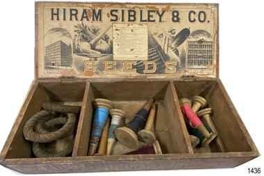
Container - Box for seeds, ca. 1880s
This seed box was made for Hiram Sibley for his seed house business. He sold seeds priced by the weight or the space they took up e.g. bushel. This box allowed for seeds to be divided by type, size or even date. The box was strong and easy to cart and store. It was also a handy item to 'recycle' as a storage container for other items. The Sibley seed box is a desirable collectors' item. A large variety of sizes and shapes are still available today in various stages of condition. Hiram Sibley developed seeds that were strong and the plants that grew from these seeds produced many seeds. Varieties of Sibley seeds and plants are still advertised for sale in modern times. HIRAM SIBLEY (1807-1888) - Hiram Sibley was born in America. He had a natural mechanical ability and became skilled in many trades. He and his partner Don Watson opened a sawmill then a machine shop and foundry. He became involved with Alfred Vale and Samuel Morse and their work on the telegraph. Eventually he became the first president of the Western Union Telegraph Company. Later, after leaving Western Union in the early 1860s, Sibley bought and sold railroads, manufactured sold, ran timber mills, and became involved in farming and seed supply. In this area he used his skills to engineer seeds that were stronger and develop plants that produced more seeds. The production of seeds became his main business. He bought land cheaply and improved to soil so that he could produce seed and grain, and graze herds of cattle. He became the owner of 14 large farms. Hiram Sibley earned the reputation "as the most extensive farmer and seedsman in this country". The business of Hiram Sibley & Co. was conducted his warehouse in Rochester and his seed house in Chicago. One department of the business sold farming equipment, another department imported ornamental plants from overseas countries Sibley went on to invest a large amount of money in a bank, and to be financially involved in the community by making large donations to public services such as a library and a school of music. At one point he was the richest man in Monroe county.This box is significant for its historic connection with Hiram Sibley, who is famous for many reasons, among which is his very profitable business of seed engineering to improve the production of crops. This box also represents the value of containers used for selling products in the 1880s, being re-used for other useful purposes. The box is an example of goods imported for use in Australia. The text and images of the box are an example of 1880s advertisingBox, wooden, with two brass hinges joining lid to base. Base has two wooden partitions, divided into three unequal sized compartments. Lid's underside has label with drawings of buildings and produce, text with maker's name and description of vegetables. Front edge of box has stencilled text and diagrams. Outside lid, and the other three sides, have no inscriptions. Made by Hiram Sibley & Co., USA. (Box is currently used to store quoits 1436.2 and cones of cotton thread 1436.3.)Marked "HIRAM SIBLEY & CO / SEEDS", "WAREHOUSE - "ROCHESTER N.Y. ", "SEED HOUSE - CHICARGO, ILL.", "SEEDS BY WEIGHT & MEASURE", "PUT UP BY / HIRAM SIBLEY & CO. / ROCHESTER, N.Y. AND CHICARGO, ILL."flagstaff hill, warrnambool, maritime village, maritime museum, flagstaff hill maritime museum & village, hiram sibley & co, rochester n.y., seeds, wooden seed box, seed box, seedsmen, arable farming, chicargo illinois, seed house, seed engineering, seed distribution, seeds by weight and measure -
 Federation University Historical Collection
Photograph, James (Jim) Smith of Happy Valley
James (Jim) Smith, (died 03/08/1974, aged 93 years) established an orchard growing snow apples in Happy Valley after returning from mining activities in South Africa. The orchard was called "Springdallah" and was beside the Linton/Happy Valley Road across from the old Happy Valley railway station. Jim was the son of George Henry Smith (18/12/1840 - 26/11/1903) and Emma Keys Smith born Keys (07/08/1842 - 28/08/1888). George and Emma left Liverpool with other unassisted immigrants on the "Bates Family" with baby Clara on 08/06/1863 arriving in Melbourne on 08/06/1863. George and Emma emigrated to Australia on the invitation of Emma's brother Edward Keys who owned a property near the school at Happy Valley on which there were two houses. Teddy offered George and Emma the smaller one to live in. When "Teddy" decided to go into hotel keeping George took over the 200 acres of his property and made it a pleasant orchard and garden called "Cress Green Gardens". George had various secretarial jobs - rate collector; paymaster at the mines; until he became Shire Secretary for the Shire of Grenville, whose centre was Linton and Government Auditor for Western Victoria (1894-1903), the means of transport being horse and buggy. Another son followed his father as Shire Secretary. George and Emma had 14 children, Emma dying giving birth to Emma Keys who lived for 16 months. George later married Annie Bolte with 2 more children being born. Annie later sold the property. The land was used for grazing and the two houses fell into disrepair. In 1995 George's grandson Ernest (Alf) Alfred Watson visited the site and reported a wrought iron gate at the site and a mulberry tree near the site of his grandmother's family home. Bluestone blocks can still be seen in the paddocks from the roadside. Jim Smith was the brother of Clara Emma Yung nee Smith.Sepia photo of two men and a girl. One of them is Jim Smith who established on orchard at Happy Valley. He also went to South Africa - mining activities. The orchard is now part of Clarkesdale Bird Sanctuary located at 360 Linton-Piggoreet Rd, Linton, Vic. 3360. Verso: Jim Smith South Africa (Mining) Established orchard halfway between Yendon and Happy Valley. Clara Emma's brother. [ Orchard established near Linton at Happy Valley.]jim smith, james smith, clara emma smith, happy valley, yendon, piggoreet, south africa, mining, orchard, edward keys, george henry smith, emma keys smith, clara emma yung, annie bolte, shire of grenville, clarkesdale bird sanctury -
 Ballarat Heritage Services
Photograph - Digital photograph, Dorothy Wickham, Winter's Swamp, Ballarat, January to April 2014
Study of Winter's Swamp commissioned by BEN and completed by BHS. The swamp was named after one of the first European settlers in the district. Winter Swamp LAT -37 32 LONG 143 47, Parish of Dowling Forest, County of Grenville Winter Swamp, on the southwest corner of Ballarat West Town Common, was not included in the original proclamation of the Common in 1861. However, being marshland, it was not considered suitable for grazing, so was added to the Common soon after 1861. Winter Swamp is a large wetland with native and exotic pasture significant for wildlife. John Winter (Jock) was born in Berwickshire, Scotland. He married Janet Margaret Irving the daughter of Robert Irving, advocate, Bonshaw, Dumfries, Scotland. Winter died in Ballarat in 1875 and was buried at the Ballaarat Old Cemetery. He took up the run Bonshaw from 1841; Leigh River Buninyong 1842-46; Junction, Delatite, March 1851 to September 1862; with sons: Carag Carag and Corop, April 1857 to September 1872; Colbinabbin and Stewart’s Plains, April 1857 to December 1872; St Germains February 1867 to March 1871. (The name became Winter-Irving in 1890). Mr John Winter, who died on August 22 at the age of 72, was a man of some note it the mining community of Ballarat. He was a self-made man, and one of our oldest colonists, it being over a quarter of a century age since he took up county about Ballarat and settled at Bonshaw. He died very rich. It is calculated that if he had retained an interest in all his runs, his income must have been not less than £10,000 or £50,000 a year. Some eight or ten years ago he sold his Bonshaw pre-emption to the Bonshaw Gold mining Company for £20,000, and a few years later the ground belonging now to Winter's Freehold Company brought him £50,000 more, the payment being made at the requisition of the deceased in sovereigns. In these relations Mr. Winter has been closely identified with the mining industry at Ballarat. The deceased was a native of Lauder, in Berwickshire, and landed in Victoria several years before the gold discovery.The principle task of this project was the delivery of a report outlining the history of European settlement in the Skipton and Cardigan/Ballarat districts as pertinent to the use of and impact on the natural environment of the two reserves Skipton Common and Winter Swamp. The report was delivered in digital form only. The report, upon completion, was presented to the Network’s Committee in order to discuss the project. The report identified and described the uses of Skipton Common and Winter Swamp, and their impacts. In particular, this report examined farming/grazing (official and informal), mining, vegetation removal (including the removal of woodlands for timber, grasslands for pasture improvement) & use of riparian areas for access to water and timber removal. Recording the more benign and environmentally friendly uses such as picnicking, community activities, nature walks and the roles of organisations such as Field Naturalists’ and Bird Observers’ clubs, school and scout/guide groups will be relevant in helping to depict overall community attitudes towards the reserves; e.g.: has the Common generally been viewed as little more than a grazing paddock and fire hazard; has Winter Swamp always been the unknown natural asset that seems to have been its lot for at least the past 40 years? In this regard, the more contemporary history of actions surrounding the use and management of the reserves is of particular interest, in view of the extant evidence at both reserves; e.g. the actions of the Shire of Ballarat in the 1980s in establishing Winter Swamp as something of a competitor to Lake Wendouree but with a more environmental bent (although almost none of the plants used are indigenous species, but that is part of the story); the trotting track constructed on Skipton Common in the 1960s following representations to Premier Henry Bolte and the cropping of the western section of the Common to raise funds for the town’s new swimming pool, the fertilizing of the land putting an end to the native grassland vegetation. There are obviously multiple sources of information to source in preparing the report, however sources that the contractor is specifically requested to consult are the Skipton Historical Society, the former Skipton Common managers (specifically Graeme Pett), the Cardigan Windermere Landcare Group and the Learmonth Historical Society (believed to hold many of the former Shire of Ballarat’s records pertaining to the Council’s role as the Committee of Management for both Winter Swamp and the Ballarat West Town Common – Winter Swamp was split between 2 separate Crown Land tenures). The contractor is also encouraged but not required to utilise community newsletters, such as the Skipton Community Newsletter, to publicise and seek information about the project. Skipton Historical Society (Mary Bradshaw) contacted on Thursday 12 June 2.30pm. Mary lived on a farm out of Skipton but is currently living in the township. She remembers walking along the creek of the Common especially in spring and autumn in bare feet and that it was a very pretty place. There were a few snakes around the waterway in summer. People put cows and a couple of horses on the commonage to graze. Graeme Pett has always lived close to the Common and would know a lot about it. Other possible contacts would be Nicole Petress, Secretary of the Progress Association, and the Corangamite Council, Camperdown. Digital images of Winter's Swampwinter's swamp, ballarat, john winter, ballarat environmental network, mullawullah -
 National Wool Museum
Painting, The White Farm, 2020/21
The farm buildings that Linda Gallus has studied and painted are on the farmland adjoining the Leura Park properties in Curlewis, on the Bellarine Peninsula. The current owner of the property told Linda that he bought the farm in 1994. He has used it for both sheep and cattle grazing since purchasing the property. When the farmer bought the land all the buildings on the property were painted white for sale, despite the fact they were very old. The shearing shed was in use up until the time of sale but was in a bad state of disrepair. The roof, stumps and floor required replacing. The building was no longer in use after the sale, so the shearing shed gradually fell into further disrepair. The previous owner had also used the property for growing potatoes, crops and livestock, mainly sheep. Linda’s fascination with the property came when she caught a glimpse of the white chimney over the hill driving towards Point Lonsdale, which still stands proud today on the roof of the old shearing shed. The owner kindly allowed her to visit the property over the past few years to capture the buildings using photography and painting. During this time many of the buildings have fallen. Linda calls it The White Farm as there are remnants of that original white paint on the outside of most of the buildings giving it a strange and rather beautiful patina. The structures are wonderful remnants of the history of the Bellarine. Linda first spotted the old shearing shed when she was driving home to Clifton Springs from Geelong. It was the white chimney on the shearing shed that stood out behind the rolling grassy hills. It was intriguing – bright white and still in good condition, unlike the rest of the building. After further investigation Linda got to know the owner of the property and visited it frequently to draw, take photos and paint. There is a variety of lovely old buildings on the property, but it was the shearing shed that held extra fascination for Linda. The most intriguing thing for Linda was that the buildings were all painted white at some stage and now the patina of peeling paint and bleached timber brought a wonderful mood and feeling to the farm. This is what she has tried to capture in this series of 11 paintings. Most of the buildings are falling, so Linda felt an urgency to capture them using acrylic paint on canvas in order to commemorate them forever.Acrylic Paint on Canvas. The images both feature a falling down shearing shed as the central focus. The wood of the shearing shed is a central theme of importance. The old buildings were painted white for sale despite being in a state of structural instability. After time this same painted wood has been left with an interesting complex patina like film on the surface which the artist has taken great care to capture. Image 1 is titled ‘Another gust of Wind’. It shows the exterior of the shearing shed which is in the process of collapsing from the forces of mother nature. In the background of this painting another of the buildings in the ‘White Farm’ complex is visible, in addition to blue skies and overgrown green grasses. Image 2 is titled ‘Green Trough’. It features the interior of the same collapsing shearing shed. The image is painted as though the viewer is peering through a crack of the external wall. Internally a green trough is seen hanging on an internal fence. Unlike everything else in the shearing shed, the trough appears new and in good condition. It provides a strong juxtaposition to the rest of the shearing shed, and the larger surrounding ‘White Farm’ complexbellarine peninsula, the white farm, shearing shed