Showing 613 items
matching location map
-
 Ballarat Tramway Museum
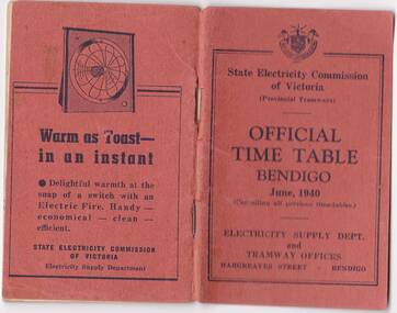
Photograph - Digital image, State Electricity Commission of Victoria (SECV), "Official Timetable Bendigo June 1940"
Yields information about the Bendigo Tram services.Digital image or copy of the SEC "Official Timetable Bendigo June 1940", 22 image files - 44 pages, giving details of the fares, transfers, luggage or parcels, lost property, times of each tram on the Quarry Hill, Eaglehawk, Lake Weeroona and Golden Square for both directions and Monday to Thursday, Friday, Saturday and Sunday. Has a number of advertisements for SEC home equipment, cookers, toasters, refrigerator, electric radiators and hot water. In the middle page is a map of the Tramway Routes, which has been hand drawn to shown North Bendigo and the depot location. Inside the rear cover, on a sheet headed "Memorandum" is a photograph, taped in of a conductor loading a pram onto a Birney tram. Under the photograph is in ink "Len Smith (Geelong)" See item3127 for an original copy and pdf scan. trams, tramways, bendigo, timetables -
 Ballarat Tramway Museum
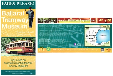
Pamphlet, Ballarat Tramway Museum (BTM), "Fares Please! / Ballarat Vintage Tramway", Jun. 2014
Printed single sheet pamphlet, advertising BTM Vintage Tramway, titled "Fares Please!" featuring Frank Puls, a 1/- ticket and tram 26 on one side, map, details and McDonalds Wendouree on reverse. Printed in green, orange and black and white on light art paper. Includes BTM web address and McDonald's logo on rear, giving five locations of McDonalds, including the Western Highway at Ballan, Tourism and Museum Accreditation logos Introduced late June 2014. The 2014 version has the web address on the bottom edge of the front, Facebook logo and QR code on the rear. Map revised to include Wendouree Railway Station, Care, and the POW Memorial. See Reg Item 2443 and 4453 for previous versionstrams, tramways, mcdonalds, btm, ballarat vintage tramway, botanical gardens -
 Ballarat Tramway Museum
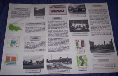
Poster, Georgia Foley, "Changing Environments - Ballarat Tram Depot", mid 1990's
Yields information from a students eyes about the history of the tram depot and how the associated environment changed and why. Has a strong association with the student.Poster prepared for a school assignment, titled "Changing Environments - Ballarat Tram Depot", features 6 photographs of the tram depot, maps, story boards pasted together onto a large sheet of heavy paper with Velcro mounts on the rear. Looks at the purpose, the location, the site characteristics, what changed, history, cause of change and likelihood of future change. Prepared by Georgia Foley Year 11C - school unknownTop right hand corner has the student's name in ink and on the rear a bibliography advising of Richard Gilbert's assistance.trams, tramways, depot, posters -
 Ballarat Tramway Museum
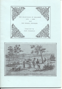
Book, Jack Cranston, "The Goldfields of Ballarat 1851 - 1886 and The Eureka Stockade", 1970's?
Book - "The Goldfields of Ballarat 1851 - 1886 and The Eureka Stockade", compiled by Jack Cranston. Comprises blue cover with 28 pages folded and stapled inside and fold out map glued to the inside of the rear cover, "Map of Ballaarat and Sebastopol" showing the various leads and gold bearing reefs of the goldfields. Also shows the location of Eureka Stockade and Sovereign Hill. Published for the Sovereign Hill Association, 1970's? Looks at the Goldfields, sources of Nuggets, mining population and statistics, the Miners Rebellion and the Stockade. Has numerous illustrations and copies of posters.trams, tramways, gold, eureka, sovereign hill -
 Ballarat Tramway Museum
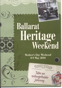
Programme, City of Ballarat and Creative Brand Studio, "Ballarat Heritage Weekend", May. 2010
Fifty two page programme book titled ""Ballarat Heritage Weekend" for Mother's Day Weekend 9 - 9 May 2010. Outlines events that were planned to be undertaken during the weekend, exhibitions, events, gardens museums and activities, including guided tours and maps with photographs of the various locations. The BTM provided a free tram service using the horse tram and one electric tram. Horse Tram rides listed under activities page 33 and 35 and the BTM listed under Museums page 43.trams, tramways, city of ballarat, heritage, horse tram, btm -
 Ballarat Tramway Museum
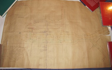
Drawing, Electric Supply Co. of Vic (ESCo), Tramway Power supply arrangements 1914, Jan. 2014
Yields information about the electrical power supply and overhead switching for Ballarat in 1914.Rolled drawing showing Tramway Power supply arrangements 1914, track map, power station, feeder cable, switches, section insulators, box locations, lightning arrestors and feeder cables for the various routes in Ballarat. Dated 2/1/1914, with initials GL. The various cables and trolley wire has been drawing in differing colours.ballarat, power station, overhead, section insulators -
 Queenscliffe Maritime Museum
Drawing - Drawing showing the Queenscliffe Maritime Centre's [QMC} location in 1987, Map showing QMC location in 1987, 1987
... Map showing QMC location in 1987.... [QMC} location in 1987. Map showing QMC location in 1987 ...Queenscliffe Maritime Centre historyLocation map of the original Queenscliffe Drawing showing the Queenscliffe Maritime Centre's [QMC} location in 1987.Reverse " NIL " -
 Bendigo Historical Society Inc.
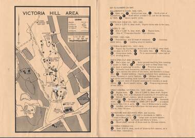
Map - VICTORIA HILL AREA
Map of Victoria Hill Area printed on yellow paper. Details of tracks, cuttings, contours (in Metres) and Anticline. Location of mines, open cuts and buildings are shown. Numbers on map are: Ballerstedt's Claim 1 - 5; North Old Chum Co. 6; Lansell's 180, 7,8,11; Battery 9.10.12; Victoria Quartz Co. 13 - 17; Rae's Open Cut and Vicinity 18 - 28, Great Central Victoria Co 29 - 36, Adventure and Advance Area and vicinity 37 - 40 and Victoria Consols Co 41.map, bendigo, victoria hill, victoria hill area, victoria consols, new chum anticline, great central victoria, rae's open cut, w rae's home, victoria quartz, ballerstedt's open cut, lansell's 180, north old chum, central nell gwynne, john brown factory, gold mines hotel, cleopatra needle type chimney, floyd's battery, ballerstedt's 24yd claim, humboldt shaft, wittscheibe's jeweller's shop, luffsman and sterry's claim, victoria hill reserve, mines dept reervation -
 Bendigo Historical Society Inc.
Document - HERITAGE REPORT: FORMER POLICE STATION AND QUARTERS: CALIFORNIA GULLY
... , Physical Description 1, Map of Early Photo Location, Bendigo Parish... Description 1, Map of Early Photo Location, Bendigo Parish Plan circa ...Seventeen page Heritage Place Report on the Former California Gully Police Station at 15 Thorpe Street, California Gully. It is the former police station and quarters, former timber stables and timber cottage residence demolished and horse paddock on separate title. Report includes a Statement of Significance, Place History (History of the Area), Policing California Gully Goldfields, History of the Buildings, Chronology of Ownership, Rate Books 1858, - 1867 - 1868, 1895 Borough of Eaglehawk Rates, 1922 Voters Roll, 1952 & 1962 Sands & McDougall Directory Thorpe St California Gully, Comparable Examples, Secondary Sources, Description Conservation Policy Guidelines (Specific), Physical Conditions, Physical Description 1, Map of Early Photo Location, Bendigo Parish Plan circa 1870, Certificate of Title 1950 & 1960. Pge 14 has plans, maps and an aerial photo of 15 Thorpe Street. Page 15 has an aerial photo of 15 Thorpe Street, California Gully with Allotment Size. Page 16 & 17 has photos.heritage, heritage report - former police station and quarters - california gully, city of greater bendigo, wilson & ass, butler, amanda jean, johnson reef shafts no 1 & 2, rose of denmark, princess dagmar, bendigo amalgamated goldfields company, captain frederick standish, royal irish constabulary, e thorpe, campbell, taylor, watson, brown, hosken, mckowne, mcqualter, parker, hicks, eaglehawk municipal council, victorian police force, d bannear, historic mining sites in the sandhurst eaglehawk and raywood mining divisions, department of conservation and natural resources, joshua thorpe, thorpe & co, johnson & co, william thorn, michael thomas, james murdock, edward c brown, francis youlden, gold escort, water police, mounted police, city police (melbourne), geelong police, gold fields police, rural bench constabulary, the people's force, robert haldane, n wild, streets of the borough of eaglehawk, police registration act, william henry mitchell, camp hotel, j o c nieman, j m catarach, g w hosken, margaret hosken nee mckown, majorie alice mcqualter, kellie anne mcqualter, adam joseph doolan, mr hicks, sands & mcdougall, hill george, meeking howard, mcewan frank a, jinks stanley, mccaig mrs eleanor, gordon john l, mcqualter mrs adeline, maher william l, raynor robert, flack john p, whitehead miss a, sang george t, linddsay john p, dyer henry, jackman george a, tibbetts mrs s a, hosken mrs margaret winifred nee mckowne, chaplin frank w, wilson c e, wright george, miller g a, sheyhill basil hugh, marshall r, miles j h, parker w b, barkla w g, nicholls les, cartledge clifford william, cole charles basil, farmers citizens trustees co, bev hanson -
 Bendigo Historical Society Inc.
Slide - Peter Ellis Collection, Kaweka Wildflower Reserve, Castlemaine, Lightning Hill Lookout Bendigo, One Tree Hill Lookout Tower Bendigo, Kamarooka Forest Area, c1970-1972
... is still managing the park. Vicroads Edition 6: Map 59E2, 628 H4... is still managing the park. Vicroads Edition 6: Map 59E2, 628 H4 ...Kaweka Reserve is a a small reserve of approximately 8ha. The land was donated to the Castlemaine City to be a wildflower Reserve. A management committee was formed in 1966. The committee is still managing the park. Vicroads Edition 6: Map 59E2, 628 H4 Location. Turner St, Castlemaine. From the Castlemaine Post Office, drive north (towards Bendigo) and turn right along Turner Street to the park entrance. What to do: walk along some of the tracks through the park follow the nature trail bird watch have a picnic at the picnic tables. RUSH Dam is a basic free camping area sits alongside Rush Dam in the Greater Bendigo National Park, featuring a single picnic table and wood fire barbecue.Peter Ellis Collection: Seventeen slides of Kaweka Wildflower Reserve, Castlemaine, Lightning Hill Lookout Bendigo, One Tree Hill Lookout Tower Bendigo. Also the Rush Dam free camping area at Kamarooka. Also a slide of an unknown group having a meal or day out; perhaps also a working bee. In addition there are two slides of a house - location not specified; and a working bee clearing along a pipeline at Big Hill. Peter was a chemistry lecturer at the Bendigo Institute of technology.history, bendigo, peter ellis collection, whipstick bendigo, bendigo state forests, kaweka wildflower reserve castlemaine, one tree hill lookout bendigo, lightning hill lookout bendigo, kamarooka, rush dam kamarooka, greater bendigo national park -
 Bendigo Historical Society Inc.
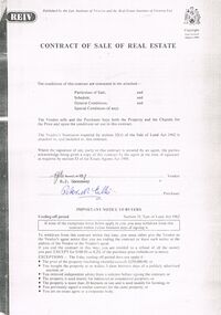
Document - PETER ELLIS COLLECTION: CONTRACT OF SALE
Copy of Contract of Sale of Real Estate and associated papers for property located in Flora Lane, Flora Hill which was purchased by Peter Ellis on 26 May 1993. Contract is in booklet with other loose papers. Contract includes General Conditions, Particulars of Sale, Special Conditions, Guarantee, Vendors Statement to the Purchaser, Shire of Strathfieldsaye Land Information Certificate, Planning Certificate Request for Building Approval Particulars, Coliban Region Water Authority Information Statement, Property Inquiry Application Form, Request for Property Information from Vic roads, Advice on Mine Subsidence Hazard (Department of Energy & Minerals), Map, Copy of Certificate of Title and Folder Numbers. Loose pages include Building Control Act 1981 Inspection Notice, two plans of building, Three plans (Coliban Water Asset Location) of Flora Lane where property is situated, 2 dated 13/11/2007 (have New Carport drawn beside house) and 1 dated 22/11/2007. Last page has specifications for car port.bendigo, house, peter ellis oam, peter ellis collection, reiv, law institute of victoria, real estate institute of victoria ltd, e j gannaway, peter n ellis, ray white bendigo pty ltd, e m monotti & son, rogers and every, craig watts, shire of strathfieldsaye, coliban region water authority, sec, g & fc of vic, telecom, vicroads, bruce l phillips, k deps?, department of energy and minerals, robert james sanderson, t flanagan, land titles office victoria, harston partridge & co pty ltd -
 Bendigo Historical Society Inc.
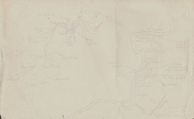
Document - PETER ELLIS COLLECTION: SKETCH OF THE BARFOLD GORGE
Two hand sketched maps on same sheet of paper, one of the location of the Barfold Gorge in relation to surrounding towns, Mt Alexander and Turpin;s Falls. The second map is a part of the Campaspe River location of the Barfold Gorge. Shown is the location of columns, pools, type of rock, Mitchell's Falls, tunnel, cave, Queen's Falls, house, windmill, fences and places where access to the bottom of the gorge is possible. Car track and scale of 1 mile = 6 inches are also shown.place, land, barfold gorge, peter ellis collection, mitchell's falls, queen's falls, turpin's falls -
 Bendigo Historical Society Inc.
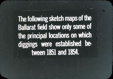
Slide - DIGGERS & MINING: THE DIGGINGS - THE DIGGERS
Diggers & Mining: The Digging - The Diggers. Slide reads: The following sketch maps of the Ballarat field show only some of the principal locations on which diggings were established between 1851 and 1854. Markings: 9 994.LIF:6. Used as a teaching aid.hanimounteducation, tertiary, goldfields -
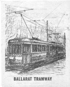 Ballarat Tramway Museum
Pamphlet - advertising the Museum, Ballarat Tramway Preservation Society (BTPS), 1975
Pamphlet advertising the Museum, with a sketch of tram 40, with the name "Ballarat Tourist Tramway" on the rear and giving visiting details and fares. Has a map on the rear showing the location and track along Wendouee Parade. See item 6296 for an earlier example. Yields information about BTPS Marketing c1975.Duplicated quarto sheet two sided on white paper.tramways, ballarat, btps, map, drawings, sketches, fares, operations -
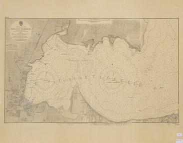 Queenscliffe Maritime Museum
Map - Chart of Geelong Harbour, Geelong Harbour
When Hamilton Hume and William Hovell arrived at the bay in 1824 they met with the local Wautharong people who referred to the bay as "Jillong" and the surround land "Corayo", but by the time the area was surveyed in the late 1830s the Aboriginal names had been swapped. The names "Corayo" and "Jillong" had since been Anglicised to "Corio" and "Geelong".Corio Bay is an important harbour and leisure location in the West and continues to attract development such as the new Tasmania Ferry Terminal.An Admiralty Chart of Geelong Harbour revised in 1954Geelong Harbour Map Ref: 2731geelong, corio, admiralty charts -
 Bendigo Historical Society Inc.
Document - NEVILLE KING COLLECTION: OCCUPATION CERTIFICATE HOMESTEAD FARM NO. 15/939 IN THE NAME OF DAVID WILLIAMS AT A COST OF ONE POUND, DATED 25 SEPTEMBER 1897, 1897
Under the Western Australia 'the Homestead act 1893' an Occupation Certificate, Homestead Farm No. 15/939 for David Williams of Bendigo for 160 acres (near Woolkabunning near Bunbury WA); at a cost of one pound. Signed by order of the Commissioner of Crown Lands. Dated 25 September 1897. The land is marked and distinguished in the maps and books of the Department of Lands and Surveys of the said (WA) Colony as Williams Location No. 702. -
 Ballarat Tramway Museum
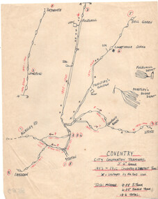
Drawing, Coventry City Corp Tramways
Wal Jack had an extensive range of correspondents throughout Australia and the world who often provided him with detailed drawings and notes on various tramway systems. Drawing shows the various lines, crossing loops, depots, routes with numbers and the location of bomb damage during 1940 air raids. The gauge of the system was 3'6". The Wikipedia reference reports that the system was closed as a result of extensive damage during the air raids. Not known who prepared the drawing.Yields information about Wal Jack's correspondents and their extensive work.Drawing - red and black ink on quarto paper, Coventry tramway system.letters, wal jack, drawings, maps, coventry, uk. -
 Ballarat Tramway Museum
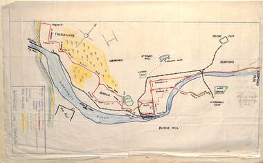
Drawing - Map or Plan, Wanganui Tramways NZ, 1945
Wal Jack had an extensive range of correspondents throughout Australia and the world who often provided him with detailed drawings and notes on various tramway systems. Drawing shows the various lines both railways and tramways, crossing loops, locations and features of the Wanganui NZ tramway system in 1945. Drawn by an unknown person; has an initial in the bottom right hand corner.Yields information about Wal Jack's correspondents and their extensive work.Drawing - red and black ink, colour pencil on foolscap paper of Wanganui Tramways NZ 1945letters, wal jack, drawings, maps, wanganui nz -
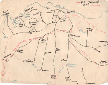 Ballarat Tramway Museum
Drawing - Plan and notes, Wal Jack, Auckland NZ tramways, 1945
Wal Jack had an extensive range of correspondents throughout Australia and the world who often provided him with detailed drawings and notes on various tramway systems. This set of notes on the Auckland tramway system, both the main city, Auckland Tramway Board and the north shore - Takapuna Tramway and Ferry Co shows the various routes, locations and terminals. The hand written sheets provide opening dates of the various routes and gives the total miles and number of cars as at 31-3-1945. Based on the handwriting, prepared by Wal Jack himself.Yields information about Wal Jack's extensive recording and research work.Set of two drawings - black, red and blue ink on quarto size paper and two sheets of notes on the Auckland tramway system c1945.letters, wal jack, drawings, maps, auckland, takapuna nz -
 Ballarat Tramway Museum
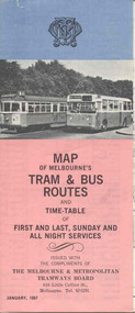
Map, Survey and Mapping for MMTB, "Map of Melbourne's Trams and Bus routes and all night services", Jan. 1967
Fold out sheet coloured map, 12 portions or folds, - title - "Map of Melbourne's Trams and Bus routes and all night services" map shows trams lines, route numbers, terminal points, bus routes, railway lines, blow up of city area with places of interest and key. On rear details, places of interest, suburb index, index to routes, first and last services, Sunday am services, all night bus services and locations of depots and head office. 2nd copy added 11-8-2006. Images of document - scanned to A3 size and overlapping added 30/10/13 On rear "out of date" stamp and 1 "cancelled" stamp - red ink.trams, tramways, melbourne, map, tram & bus services, all night services -
 Ballarat Tramway Museum
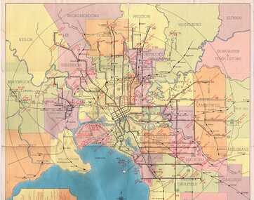
Map, Compiled by MMTB, "Map and timetable of Melbourne Tram and Bus Services" - May 1956, May. 1956
Fold out map (10 sections), coloured of Melbourne's Tram and Bus routes, route numbers, rail lines, municipalities boundaries and location of major places of interest. At base of map - timetable of all night trams and bus services. On rear index to routes, 1st and last services, time of Sunday am services, Latrobe St. services and photo of Wattle Park.trams, tramways, melbourne, map, tram & bus services, all night services, mmtb -
 Kew Historical Society Inc
Plan - Subdivision Plan, H C Crouch, Old Golf Links Estate, 1930s
The land in North Kew between the Outer Circle Railway and the River Yarra was released in sections. This release included 80 lots. Most of this area was released during the Depression years in the early 1930s.Subdivision plans are historically important documents used as evidence of the growth of suburbs in Australia. They frequently provide information about when the land was sold on which a built structure was subsequently constructed as well as evidence relating to surveyors and real estate and financial agents. The numerous subdivision plans in the Kew Historical Society's collection represent working documents, ranging from the initial sketches made in planning a subdivision to printed plans on which auctioneers or agents listed the prices for which individual lots were sold. In a number of cases, the reverse of a subdivision plan in the collection includes a photograph of a house that was also for sale by the agent. These photographs provide significant heritage information relating house design and decoration, fencing and household gardens.One part of a massive subdivision of the Old Golf Links Estate in North Kew of 80 allotments bordering Sutherland Avenue, Ramsay Avenue, Belford Road, Beresford Street and Coleman Avenue. Inset on the plan at the top left, the route of the Outer Circle Railway is clearly marked. The Kew Golf Links is identified in its current location. The land on which Greenacres Golf Club was to be constructed is at this time marked as ‘Recreation Ground’. The ‘new bridge’ over the Yarra at Burke Road is also marked on the inset map. The Plan identifies the surveyor (sic) H.C. Crouch BCE MVIS, 443 Little Collins St., Melbourne. The date of the subdivision auction sale in identified as Saturday September 25th at three o'clock.Annotations: "E" top left. "Golf Links" top right. Lots 73-76 ticked and listed as "6" poundssubdivisions -- kew (vic.), old golf links estate -
 Kew Historical Society Inc
Plan - Subdivision Plan, Kew Golf Links Estate, 1936, 1936
The Kew Golf Links Estate was a major subdivision in North Kew. It derived its title due to the land being previously occupied by the Kew Golf Club, which transferred its course to a number of locations before occupying its current site. The Plan advertises 180 choice home sites. The street names are somewhat different today as those on the map are named after the proposed Kodak Factory to be built on the site. The subdivision of the Kew Golf Links Estate was a major subdivision of farmland in Kew. The site was at one stage designated for industrial development and the building of a new Kodak factory. The decision by Council to oppose the redevelopment makes the beginning of the period when all industrial development was banned in Kew.Monochrome printed, folded subdivision plan for the Kew Golf Links Estate, to be auctioned on 7 November 1936. Streets named include: Carnegie Avenue, Willsmere Road, Kilby Boulevarde, Kodak Avenue, Coleman Avenue, Beresford Avenue, McConchie Avenue, Cole Avenue, White Avenue, Baker Avenue, Spruzen Avenue, Tanner Avenue, Ratten Avenue, Mathers Avenue, Railway Avenue, Sutherland Avenue, and Belford Road. The position of the Yarra River and a large Drainage Reserve are marked on the plan. Lots for sale are numbered. Existing buildings are designated with a square.subdivision plans - kew (vic), kodak factory - kew (vic) -
 Kew Historical Society Inc
Map, Real Estate Map of Bulleen, Templestowe, Lower Templestowe, Doncaster, North Balwyn
A large undated printed map of Bulleen, Templestowe, Lower Templestowe, Doncaster, North Balwyn showing major and minor roads, waterways and proposed facilities in this area of Melbourne.A useful if undated real estate map that allows viewers to compare current and historic aspects of these areasMap of Bulleen, Templestowe, Lower Templestowe, Doncaster, North Balwyn used by JB Thomson & Co, Real Estate Agents, to identify and record land sales on these. There are some markings on the plan indicating the location and price of lots.subdivision plans, bulleen, templestowe, lower templestowe, doncaster, north balwyn -
 Kew Historical Society Inc
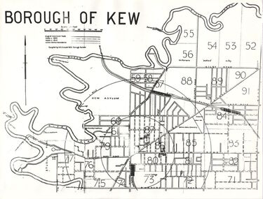
Plan, Borough of Kew, 1910
This work forms part of the collection assembled by the historian Dorothy Rogers, that was donated to the Kew Historical Society by her son John Rogers in 2015. The manuscripts, photographs, maps, and documents were sourced by her from both family and local collections or produced as references for her print publications. Many were directly used by Rogers in writing ‘Lovely Old Homes of Kew’ (1961) and 'A History of Kew' (1973), or the numerous articles on local history that she produced for suburban newspapers. Most of the photographs in the collection include detailed annotations in her hand. The overhead transparency is of a map produced by H.C. Crouch Borough Surveyor in 1910The Rogers Collection provides a comprehensive insight into the working habits of a historian in the 1960s and 1970s. Together it forms the largest privately-donated collection within the archives of the Kew Historical Society.An overhead transparency of a plan of Kew comparing the roads in 1860 with later roads constructed by 1910. Sections of the plan are marked with the location of particular buildings, farms or transport routes.Borough of Kewborough of kew, h.c. crouch -
 Kew Historical Society Inc
Plan - Subdivision Plan, J Hurrey, Section 115 in the Parish of Boroondara Near Richmond Bridge, 1853
Despite the plans claims that it is a subdivision near the Richmond Bridge, Section 115 was located at what is now Camberwell Junction. While the plan only lists government roads rather than named streets, the section was located on the east side of Burke Road, stretching up the hill from the current Junction. Research on Trove, conducted by Kerry Fairbank, discovered an advertisement for unsold lots in Section 115 which clarifies the extent and location of subsequent land sales in the original section. The original article can be viewed through the link in the catalogue record. The interesting link to Kew is the reference to James Beavan as the purchaser of lots 14 and 15. The historian Gwen McWilliam has notes that a Mr Beavan changed his name from Bevan. The Bevans were descendants of the Derricks family of Kew. This subdivision plan is the earliest original map or plan in the collection which shows parts of what is now the City of Boroondara, dating from circa 1853. It provides important information for researchers on subsequent subdivisions following the original land sales in [Camberwell] Boroondara. The site, on the east side of Burke Road is a highly-significant and historic site. This is believed to be the only extant copy of the subdivision in public collections.A small plan on parchment listing 28 lots, between one and two acres each, for sale in Section 115 in the Parish of Boroondara, dating from 1853 when the portion was subdivided.Obverse: Lot 16 "Joseph Duval", Lots 14 & 15 "James Beavan". Other annotations (measurements) are unreadable. Reverse: "KH-981 / Section 115 in the Parish of Boroondara / Near Richmond Bridge / 1640T. / J Duval / 14-15 J. Beavanparish of boroondara, subdivision plans - camberwell, section 115 - boroondara, subdivision plans -- camberwell (vic), riverscape road, burke road, camberwell junction -
 Kew Historical Society Inc
Photograph, Floods in North Kew, 1934
Living with natural processes was frequently a challenge to early European settlers and later residents of what was in the 1850s administered by the Borondara Road Board. This was compounded by the area being bounded on three sides by rivers (Yarra River, Koonung Creek and Gardiner's Creek). In 1849, the historian James Bonwick recorded that "our district [Kew] suffered considerably. Mr Wade speaks of 80 acres, out of 100 acres of his cultivated paddock, covered by water." Newspapers continued to describe major flooding in Kew in 1863, 1869, 1878, 1880, 1889, 1891, 1916 and 1934. While the construction of the Upper Yarra dam in 1957 reduced the levels of flowing downstream, local and riverine floods continue.The Kew Historical Society's pictures and map collections testify to the impact of flooding in the district. They have historical importance in documenting the extent of flooding in the district and its affects on homes, services and recreation. Numerous photographs record flooding throughout the Twentieth Century.Floods in North Kew, 1934. Unidentified location on the Yarra Flood Plain at Kew.floods (kew) 1934, yarra river -
 Glen Eira City Council History and Heritage Collection
Event Run-sheet and Map, "Booran Reserve Official Opening"
... of Proceedings of the opening ceremony. The map notes the locations... of the opening ceremony. The map notes the locations of reserved parking ...This run-sheet and map were used for the opening of Booran Reserve at the corner of Booran and Glenhuntly Roads on Tuesday 11 April 2017. The Reserve was officially opened by the Mayor, Cr. Mary Delahunty and The Hon. Philip Dalidakis, MP, Minister for Innovation. The run-sheet contains information about the Order of Proceedings of the opening ceremony. The map notes the locations of reserved parking, the route taken by Mayor Mary Delahunty and Minister Philip Dalidakis through the Reserve, and the speech and smoking ceremony site. The site of the Reserve was previously the Caulfield Service Reservoir.Black and white printed run-sheet, and green, teal, red, yellow, blue and khaki colour printed map -
 Surrey Hills Historical Society Collection
Archive - Vertical file, Armitstead family
The Armitstead family's first woodyard in Surrey Hills was located in Croydon Road but later they moved to 153-157 Union Road, Surrey Hills. The business delivered timber and briquettes for heating to homes in the local area but also blocks of ice in the days before refrigerators were a usual household appliance. The timber was unloaded from railway trucks at a siding at Surrey Hills station; some came from the Armitstead's property of 130 acres of timbered land near Killara. They also sold mallee roots and briquettes.A vertical file containing the following documents: 1. Land Victoria map of Surrey Hills including Union Road from Bedford Street to Montrose Street, showing location of woodyard (undated) (1 A3 page). 2. Possibly ‘Sun’ article ‘When Surrey Hills ran short of wood’, Michael Sefton (undated) (1 page). 3. Plaque for the red mechanism of the weighbridge at Centre, by convenor, Surrey Hills Heritage Group, 12.11.2002 (1 page). 4. Pooley and Sons weighbridge, notes by Dennis Armstrong, in email to Sue Barnett, 4.4.2013 (2 pages). 5. Laminated diagram and notes by Ken Hall re weighbridge from Armitstead’s woodyard, and photocopy, undated (3 pages). 6. ‘Armitstead’s woodyard’ 153-7 Union Road (now Neighbourhood Centre), typed Progress Leader article, 13.1.1982 (2 pages). pooley and sons weighbridge, armitstead family, woodyard, armitstead's woodyard, union road -
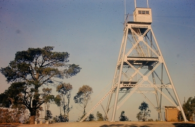
Surrey Hills Historical Society Collection
Map, Contour map of Surrey Hills showing potential sites for the Telecom Tower
The PMG / Telecom / Telstra tower was built in 1961-1963 as a relay station to support television and radio links between city and regional broadcasting stations. The tower itself was 45 m in height with a 2 storey building for equipment and staff surrounded by garden. From the beginning it was opposed by local residents. The location is said to be the second highest site in Melbourne, sometimes described as Delaney's Hill.Two A3 photocopied sheets of a map showing part of Surrey Hills, roughly between Windsor Crescent and Belmont Street (north / south) and Standard Avenue and Balmoral Crescent (east / west). The map shows contour lines and house sites, 16 of which are numbered. One sheet has been inscribed in top RH corner with notes regarding the significance of the numbers."Contour map of potential sites / for the telecommunications tower which / was eventually sited at 2. / Jock Campbell OBE was our neighbour / at 4 Theodore St when we moved into / the area in 1984. He was responsible in his / job at the PMG in deciding on the /site of the tower - Note site 5 was / behind his (& our) house. / Jack ended his career as Deputy Director / of the PMG. He sat on international committees / after WW2 to decide the split of the electronic / spectrum for radio, TV etc. / His group developed a "mobile phone" using / fixed towers but the phone was a truck full of gear."contour map, telecom tower, maps, jock campbell, john duncan campbell