Showing 841 items matching "parish plan"
-
 Bendigo Historical Society Inc.
Map - CAMPBELL COLLECTION: BENDIGO AND DISTRICT MAPS, 23-4-29
... Assessor's Plan and Parish Plan. G.W.Latimer 23-4-29. (number 385... of map. Prepared in W.P.B. from Assessor's Plan and Parish Plan ...Map. Whirrakee, Parish of Whirrakee, Total area 4419 acres, scale 20 chains to 1 inch. Unused water race in centre of map. Eucalypt Oil Distillery, bottom of map. Prepared in W.P.B. from Assessor's Plan and Parish Plan. G.W.Latimer 23-4-29. (number 385 in map cupboard 1)G.W.Latimermap, bendigo, agricultural lands -
Bendigo Historical Society Inc.
Map - CAMPBELL COLLECTION: BENDIGO AND DISTRICT MAPS
... in W.P.B. from Assessment Plans and Parish Plans. (number 380... mile. Prepared in W.P.B. from Assessment Plans and Parish Plans ...Map. Ascot, Parishes of Huntly, Sandhurst and Wellsford. Scale 20 chains to 1 inch. Total area 2818 acres. To Bendigo 4 1/2 miles, to Epsom 3/4 mile, Huntly 3/4 mile. Prepared in W.P.B. from Assessment Plans and Parish Plans. (number 380 in map cupboard 1)map, bendigo, agricultural lands -
Whitehorse Historical Society Inc.
Document, Division of Survey and Mapping, 1984
... Information guide to Parish and Township Plans - Division... Information guide to Parish and Township Plans - Division of Survey ...Information guide to Parish and Township Plans - Division of Survey and Mapping - Victorian Government..Information guide to Parish and Township Plans - Division of Survey and Mapping - Victorian Government..Information guide to Parish and Township Plans - Division of Survey and Mapping - Victorian Government..crown lands, victorian government, land surveys -
 Bendigo Historical Society Inc.
Map - CAMPBELL COLLECTION: BENDIGO AND DISTRICT MAPS
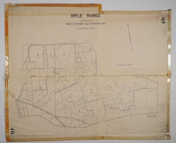
... . Compiled in W.P.B. from Assessment and Parish Plans, by H.A.D. 8-7... and Parish Plans, by H.A.D. 8-7-29 Map CAMPBELL COLLECTION: BENDIGO ...Map. Rifle Range, Parishes of Wellsford and Sandhurst. Scale 20 chains to 1 inch. Total area in plan is 5916 acres. Wallan and Bendigo Railway to Axedale Township and station 8 miles, to Longlea Railway Station 2 1/2 - 3 miles. Rifle Range. Compiled in W.P.B. from Assessment and Parish Plans, by H.A.D. 8-7-29H.A.D.(Darby).map, bendigo, allotments, bendigo rifle range, sandhurst parish, wellsford parish -
 Bendigo Historical Society Inc.
Map - Marong County of Bendigo
... On the back in blue pen: certified plan parish Marong... Marong On the back in blue pen: certified plan parish Marong ...Map of Marong. Drawn and reproduced at the Dept. of Lands and Survey, Melbourne. By authority: W.M. Houston Government Printer. June 1953.On the back in blue pen: certified plan parish Marong, signed minister and seal affixed for land S sec.72 evidence act. I certify that this a true plan parish Marong (signature illegible) minister for lands.map, marong -
Bendigo Historical Society Inc.
Map - CAMPBELL COLLECTION: BENDIGO AND DISTRICT MAPS
... in W.P.B. from Assessment Plan and Parish Plans. H.A. Darby 14-6-29.... 3972 acres. Prepared in W.P.B. from Assessment Plan and Parish ...Map. Eppalock, Sedgwick and Strathfieldsaye, scale 20 chains to 1 inch. Road to Bendigo 13 1/2 miles at top right of map, Longlea Railway Station 5 1/2 miles, Bendigo 11 miles, Strathfieldsaye 5 miles on left of map. Total area 3972 acres. Prepared in W.P.B. from Assessment Plan and Parish Plans. H.A. Darby 14-6-29.H.A.Darbymap, bendigo, agricultural lands -
University of Melbourne, Burnley Campus Archives
Plan - Coloured plan, Plan of Burnley Gardens, 1929?
... Part of larger plan (Lands Department Parish Plan). Partly... of larger plan (Lands Department Parish Plan). Partly hand-drawn ...Layout of gardens, farm buildings, orchard, etc. overlaid on part of Lands Department map. See paper catalogue for full descriptionPart of larger plan (Lands Department Parish Plan). Partly hand-drawn. Area bounded by Yarra River, Swan St, Glen Iris railway line. Shows Burnley Gardens layout, handwritten amendments and explanation of existing and proposed structures including: Pavilion, sketch of unbuilt Administrative Building, poultry yard, contours of old orchard, sketch for Plant Research Institute, ditch, silo, milking shed, laying pens. See aboveburnley gardens, pavilion, burnley school of horticulture, farm buildings, poultry -
 Greensborough Historical Society
Poster - Planning Document, City of Heidelberg, Subdivision Plan # G 27, Greensborough and Diamond Creek, 1922 and 1963
... , Parish of Keelbundoora: plan 1: Henry Street, Vermont Avenue..., Parish of Keelbundoora: plan 1: Henry Street, Vermont Avenue ...Plan of Subdivisions in City of Heidelberg: Side 1: 2 plans, Parish of Keelbundoora: plan 1: Henry Street, Vermont Avenue, Lyell Street, Nell Street, McDowell Street, 1922. Plan 2: Henry Street, Nepean Street, Charles Street, 1922. Side 2: 2 plans Parish of Nillumbik, Portion 13: Plan 1: Diamond Creek Road, Delfin Crescent, Ridge Road, 1963. Plan 2: Kinglake Road, Eltham Road, 1963.An example of hard copy subdivision plans from the Greensborough area. Mainly from the Shire of Diamond Valley era (1964-1994).Plan (2 sided) mounted on heavy card. Contains 2 sheets pasted together.Stamped and handwritten Council permissions, dates and other details.subdivision plans, city of heidelberg -
 Federation University Historical Collection
Map, Doroq County of Grenville L4935, 1911, 28 June 1911
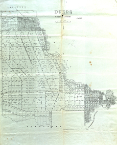
... Parish Plan of Doroq in black ink printed on cream paper... Price 1/- Parish Plan of Doroq in black ink printed on cream ...This plan is associated with former Ballarat School of Mines Student Richard Squire (1875-1876). Gift of the Squire FamilyParish Plan of Doroq in black ink printed on cream paper. It includes the township of Inverleigh and Barwon Rover. Some of the names on the plan are William McRobie, William MacRobie, Thomas Russell, W.C. Smith, John Bell, J. Moffatt, Thomas Moffatt, John Anderson, George Synnot, Charles Lloyd, William MacRobie, J. Flack, Alexander Campell, T. Maher, William Berthon. Thomas Jewell, James Carstairs, D. MCInnerney, F.H. Holland, Robert Morrison17 7/9 18 9 miles handwritten in pencil Photo lithographed at the Department of Lands and Survey Melbourne by T. E. McGauran 28.6.11 Price 1/-carrunge-murnong, murdeduke, carrah, shelford, inverleigh, barwon river, hesse, wingeel, george russell, george russell's pre-emptive section, john moffatt, w. c. smith, macrobie, john bell, thomas russell, t.f. mcgauran -
 Federation University Historical Collection
Map, Shire of Buninyong, c1970
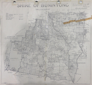
... Parish Plan. Includes Buninyong, Clarendon, Narmbool, Enfield... of Buninyong Parish Plan. Includes Buninyong, Clarendon, Narmbool ...The Shire of Buninyong was located on the southern side of Ballarat.Two maps of the Shire of Buninyong. .1) Map showing the County divisions, township boundaries, Railway line, State Forest boundary, riding boundary and shire boundary. Identifying words have been added in red and green texta. .2) Shire of Buninyong Parish Plan. Includes Buninyong, Clarendon, Narmbool, Enfield, Lychfield, SCotchman's, Navigators, Warrenheip, Scotsburn, mr Doran, Durham Lead, Cambrian Hill, Napoleons, Garibaldi, Mt Clear, Lal Lal, Bonshaw.1) B.I.A.E., St Martin's, cemetery, mt Buninyong, mt Innes, rly stn shire of buninyong, buninyong, clarendon, narmbool, enfield, lychfield, scotchman's, navigators, warrenheip, scotsburn, mt doran, durham lead, cambrian hill, napoleons, garibaldi, mt clear, lal lal, bonshaw, state forest, elaine, elaine north, cargerie, grenville, mt mercer, millbrook, wallace, yendon, canadian, kaolin deposits, mount helen campus -
Bendigo Historical Society Inc.
Map - CAMPBELL COLLECTION: BENDIGO AND DISTRICT MAPS, 8-7-29
... Assessment and Parish Plans by H.A.D 8-7- 29 (number 367 in map... in W.P.D. from Assessment and Parish Plans by H.A.D 8-7- 29 (number ...Map. Rifle Range, Parishes of Wellsford and Sandhurst. Scale 20 chains to 1 inch. Total area by Planimeter 5916 acres. Wallan and Bendigo Railway line. Rifle Range. Axedale township and station 8 miles. To Longlea Ryl station 2 1/2 miles. To Epsom 1 1/2 miles. To Bendigo 3 miles. Compiled in W.P.D. from Assessment and Parish Plans by H.A.D 8-7- 29 (number 367 in map cupboard 1)H.A.D.(H.A.Darby)map, bendigo, allotments -
 Bendigo Historical Society Inc.
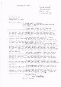
Document - CORRESPONDENCE: ESPIE AND STONE FAMILIES (LOCKWOOD)
... ); Parish plans 4 pages; 3 copies of photos - Queen's Hotel... : Petition (1857); Parish plans 4 pages; 3 copies of photos - Queen's ...1991 correspondence re Espie and Stone families (Lockwood) from Alex H Stone. Also mention of Nicholas and Johson families (Tasmania). Family history in letter and accompanying letter is a 'List of Material being sent' nominating 13 items. This list is incomplete - there is now attached : Petition (1857); Parish plans 4 pages; 3 copies of photos - Queen's Hotel, Lockwood, Lockwood Post Office, Lockwood South Post Office (Happy Jack Hotel).List of Postmasters at Lockwood from 1856.person, individual, samuel espie, espie, nicholas stone and johson families. mrs margaret m. stone of duntroon helbourne. etloe bothwell. william nicholas, anne hope, bendigo creek, sandhurst, lockwood county of bendigo, lockwood south post office opened 1909, happy jack hotel, queens head hotel lockwood, 1865 post master lockwood samuel espie, alex h. stone. -
 Forests Commission Retired Personnel Association (FCRPA)
Gunter's Chain
... in the 1970s land was measured in chains and links. Many old parish... in the 1970s land was measured in chains and links. Many old parish ...Before metrication was introduced into Australia in the 1970s land was measured in chains and links. Many old parish plans show length measurements in chains and links. Area was shown in acres, roods and perches. Gunter's chain was used for measuring distance in surveying. It was designed and introduced in 1620 by English clergyman and mathematician Edmund Gunter (1581–1626). Gunter developed the measuring chain of 100 links. The chain and the link, became statutory measures in England and subsequently the British Empire. After metrication units of length were measured in meters and area in hectares. The chain was later superseded by steel ribbon tape.The 66 foot long brass Gunter's Chain is divided into 100 links (each 7.92 inches long), and marked off into groups of 10 by shaped tags which simplify intermediate measurement. It was heavy but flexible enough to be dragged through the bush on surveying transects.(Hence the common forestry term "chainman). The chain was a precision part of a surveyor's equipment. It required frequent calibration, yet needed to be sturdy enough to be dragged through rough terrain for years. It has brass hand grips at each end of chain. 1 chain = 100 links = 22 yards = 66 feet = 792 inches. 10 chains = furlong 80 chains = 1 mile 1 acre = 10 square chains = 4 roods (1/4 acre) = 40 perches.forest measurement, surveying, forests commission victoria (fcv) -
 City of Kingston
Map - Parish of Moorabbin
... , possibly the surveyor/cartographer who drew this parish plan..., possibly the surveyor/cartographer who drew this parish plan ...Warning: This object includes historical language referring to First Nations Peoples which is no longer appropriate but has been recorded for historical purposes. Produced in 1853, this map shows the land holdings of European families. While the majority of holdings are small there are also large land holdings as can be seen with Henry Dendy's Special Survey. Of particular note is the "Reserve for Aborigines" which was established in approximately 1841 and consisted of over 830 acres. This area is the current location of Mordialloc township and Attenborough Park, in Mordialloc, is the last remnant of the reserve. An Alfred Sikes, possibly the surveyor/cartographer who drew this parish plan, purchased land in Berwick in 1854.A handrawn map on fabric, with blue markings representing the coastline to Port Phillip Bay, red markings representing a proposed train line to Mordialloc, major roads and street, as well as a "Reserve for Aborigines", which constituted approximately 830 acres. In the bottom right hand corner, the map has been signed and dated.Handwritten in ink: Alfred Sikes / 38 Collins St East / June. 1853moorabbin, mordialloc, dendy, port phillip bay, aboriginal reserve, attenborough park -
Whitehorse Historical Society Inc.
Document, Sale Plan 38, 12/09/1855
... Parish of Nunawading Sale Plan 38. Description of land... Water Supply Parish of Nunawading Sale Plan 38. Parish ...Parish of Nunawading Sale Plan 38.Parish of Nunawading Sale Plan 38. Description of land is given with water supply. Surveyor C.Hodgkinson.Parish of Nunawading Sale Plan 38. parish of nunawading, hodgkinson, clement, water supply -
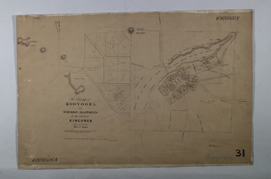 Bendigo Historical Society Inc.
Map - KOOYOORA, July 23rd 1857
... in the Parish of Kingower. This plan has been applied to a newer backing...MAP township Kooyoora Allotments Parish of Kingower Map ...Map: The Township of Kooyoora and suburban allotments in the Parish of Kingower. This plan has been applied to a newer backingmap, township, kooyoora, allotments, parish of kingower -
 Bendigo Historical Society Inc.
Document - LANDS OFFICE: DISTRICT SURVEYORS SANDHURST INDEX OF PLANS, no date probably 19C
... . Bridgewater on page 7. Plan details give allotments, parish... 7. Plan details give allotments, parish, sections, plan ...Document: dark green hard cover journal with buff spine and corners. Index in front A - Z. 400 pages, pages not indexed but numbered. Index lists places of various districts e.g. Bridgewater on page 7. Plan details give allotments, parish, sections, plan number.Lands Officelands office, index of plans, plans, bendigo -
Whitehorse Historical Society Inc.
Document, Crown Grant Register, 10/05/1999
... , 1854 - 1858. Lands Department plan of Parish, 1864..... Lands Department plan of Parish, 1864. Crown Grant Register ...Crown Grant Register - General Law - Parish of Nunawading, 1854 - 1858. Lands Department plan of Parish, 1864.land settlement, victoria. lands department, blood, robert, blood, thomas, burrell, charles, clisby, william, cook, charles, cousens, james, dickensen, william, harding, william, hedding, william, holland, john, jones, william, kefford, richard, lobb, john, morgan, robert rowland, morton, william, o'conner, patrick, orr, joseph, polak, nelson, riley, patrick, smith, l l dr, tranter, william, whitman, francis, williams, william, wilks, joseph, wilson, william, wilton, edward -
Bendigo Historical Society Inc.
Map - CAMPBELL COLLECTION: BENDIGO AND DISTRICT MAPS, 9-4-29
... . by W.J.Galbraith from Parish and Assessment Plans. (number 384 in map... Bendigo agricultural lands W.J.Galbraith Map. Campaspe, Parish ...Map. Campaspe, Parish of Kimbolton, Scale 20 chains to 1 inch. Total area 4117 acres, Campaspe River, Prepared in W.P.B. by W.J.Galbraith from Parish and Assessment Plans. (number 384 in map cupboard 1)W.J.Galbraithmap, bendigo, agricultural lands -
Bendigo Historical Society Inc.
Map - CAMPBELL COLLECTION: BENDIGO AND DISTRICT MAPS, 1929
... in W.P.B. form Parish and Assessment Plans. G.W.L. 9-4-29... inch. Prepared in W.P.B. form Parish and Assessment Plans ...Map. Campaspe, Parish of Kimbolton. Total area 4117 acres. Campaspe River, Kimbolton. Scale 20 chains to 1 inch. Prepared in W.P.B. form Parish and Assessment Plans. G.W.L. 9-4-29. (number 351 in map cupboard 1)map, bendigo, allotments -
 Bendigo Historical Society Inc.
Document - HERITAGE REPORT: FORMER POLICE STATION AND QUARTERS: CALIFORNIA GULLY
... , Physical Description 1, Map of Early Photo Location, Bendigo Parish... Description 1, Map of Early Photo Location, Bendigo Parish Plan circa ...Seventeen page Heritage Place Report on the Former California Gully Police Station at 15 Thorpe Street, California Gully. It is the former police station and quarters, former timber stables and timber cottage residence demolished and horse paddock on separate title. Report includes a Statement of Significance, Place History (History of the Area), Policing California Gully Goldfields, History of the Buildings, Chronology of Ownership, Rate Books 1858, - 1867 - 1868, 1895 Borough of Eaglehawk Rates, 1922 Voters Roll, 1952 & 1962 Sands & McDougall Directory Thorpe St California Gully, Comparable Examples, Secondary Sources, Description Conservation Policy Guidelines (Specific), Physical Conditions, Physical Description 1, Map of Early Photo Location, Bendigo Parish Plan circa 1870, Certificate of Title 1950 & 1960. Pge 14 has plans, maps and an aerial photo of 15 Thorpe Street. Page 15 has an aerial photo of 15 Thorpe Street, California Gully with Allotment Size. Page 16 & 17 has photos.heritage, heritage report - former police station and quarters - california gully, city of greater bendigo, wilson & ass, butler, amanda jean, johnson reef shafts no 1 & 2, rose of denmark, princess dagmar, bendigo amalgamated goldfields company, captain frederick standish, royal irish constabulary, e thorpe, campbell, taylor, watson, brown, hosken, mckowne, mcqualter, parker, hicks, eaglehawk municipal council, victorian police force, d bannear, historic mining sites in the sandhurst eaglehawk and raywood mining divisions, department of conservation and natural resources, joshua thorpe, thorpe & co, johnson & co, william thorn, michael thomas, james murdock, edward c brown, francis youlden, gold escort, water police, mounted police, city police (melbourne), geelong police, gold fields police, rural bench constabulary, the people's force, robert haldane, n wild, streets of the borough of eaglehawk, police registration act, william henry mitchell, camp hotel, j o c nieman, j m catarach, g w hosken, margaret hosken nee mckown, majorie alice mcqualter, kellie anne mcqualter, adam joseph doolan, mr hicks, sands & mcdougall, hill george, meeking howard, mcewan frank a, jinks stanley, mccaig mrs eleanor, gordon john l, mcqualter mrs adeline, maher william l, raynor robert, flack john p, whitehead miss a, sang george t, linddsay john p, dyer henry, jackman george a, tibbetts mrs s a, hosken mrs margaret winifred nee mckowne, chaplin frank w, wilson c e, wright george, miller g a, sheyhill basil hugh, marshall r, miles j h, parker w b, barkla w g, nicholls les, cartledge clifford william, cole charles basil, farmers citizens trustees co, bev hanson -
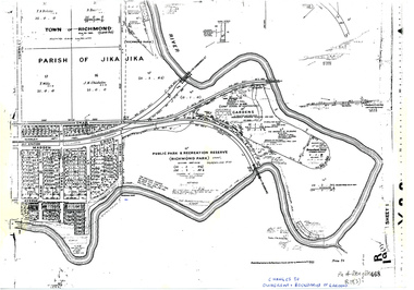 University of Melbourne, Burnley Campus Archives
Plan, Allan & Tuxen et al, Public Park & Recreation Reserve (Richmond Park), 1886-1996
... on it, dates Act revoked and Gazette numbers. Based on plan of Parish... numbers. Based on plan of Parish of Jika Jika R 19 (3) Public Park ...Shows changes in ownership of various parts of Richmond Park and Burnley Gardens including University of Melbourne, Amrad, Melbourne City Link, etc. from gazettal in 1873 to 1996Photocopy of plan of Richmond Park and Burnley Gardens with University of Melbourne land acquisition 13.10.1994 hand drawn on it, dates Act revoked and Gazette numbers. Based on plan of Parish of Jika Jika R 19 (3)"Changes to ownership & boundaries of Gardens" in inkpublic parks, recreation reserve, richmond, parish if jika jika, burnley gardens, horticultural society of victoria -
Bendigo Historical Society Inc.
Map - CAMPBELL COLLECTION: BENDIGO AND DISTRICT MAPS, 8-6 29
... Parish and Assessor's Plans. G.W.Latimer 8-6-29. (number 393... miles. Prepared in W.P.B. from Parish and Assessor's Plans ...Map. Kimbolton, Parishes of Kimbolton and Lyell, scale 20 chains to 1 inch. Area by Plamimeter 6258 acres. Coliban River, Knowsley, Strathfieldsaye 10 1/2 miles. Prepared in W.P.B. from Parish and Assessor's Plans. G.W.Latimer 8-6-29. (number 393 in map cupboard 1)G.W.Latimermap, bendigo, allotments -
Glen Eira Historical Society
Plan - St Patrick’s Roman Catholic Church, Murrumbeena
... of the parish, a plan of the church and a sketch of the church exterior... a brief history of the parish, a plan of the church and a sketch ...There is a photocopy of the commemorating booklet for the blessing and opening of St Patrick’s Memorial Catholic Church Murrumbeena on 15 August 1963. It also includes a brief history of the parish, a plan of the church and a sketch of the church exterior. Second there is an unattributed undated research note of the memorial stones for St Patrick’s Catholic Church and school Murrumbeena. Third is an unattributed, undated handwritten notes on St Patrick’s School buildings regarding teaching sisters and dates when additional classrooms were built. The fourth document is a six page brochure seeking donations from parishioners to commence on 10/04/1966. It includes the church’s financial statement, a picture of the church exterior as the cover and two photographs of the reverends. Inside the booklet.glen huntly, religious services, tweedy e. v, cremin patrick rev., murrumbeena, fox bishop, parish, north road, ellis robert o, clergy, malvern east, memorials, parish of ormond, east boundary road, dalny road, rovira william rev, quillinan james rev, church furniture, murrumbeena road., memorial stone, mannix daniel archbishop, pollard k, catholic church, m.p arbory and co., st patrick’s roman catholic church murrumbeena -
 Federation University Historical Collection
Letter, Grant Street Terraces, 1992
... for survey of Crown Allotment 11, Section 11, Parish of Cardigan... to a request for survey of Crown Allotment 11, Section 11, Parish ....1) 5 pages of correspondence relating to a request for survey of Crown Allotment 11, Section 11, Parish of Cardigan (included plan) .2) 3 pages relating to a tender for Bluestone / drystone terraces along the Grant Street frontage of the Ballarat School of Minesballarat school of mines, grant street, gillies street, j. winter, e.a. wynne, w.b. ochiltree, ballarat industrial school, prince of wales park, ballarat golf club -
Glen Eira Historical Society
Article - Glen Eira
... Third attachment to above letter of questions and parish plan... and parish plan image re properties including area occupied by Glen ...Six items about the Glen Eira Mansion. Letter dated 2/06/2012 from the St Kilda Historical Society to Glen Eira Historical Society asking for further information as well as providing some items on Glen Eira’s history Attachment to above letter of information about Glen Eira printed from Melbourne Mansions Database on 30/05/2012 about Glen Eira House referencing the Argus newspaper for 10/03/1865 and 25/07/1881, ‘Sand, Swamp and Heath’, ‘Caulfield’s Building Heritage and Pioneer Families’. Entry is dated 27/06/1997. Second attachment to above letter of a memo detailing information about Glen Eira mansion form History and Heritage Officer at City of Glen Eira together with an image extract of birth notices from the Argus 22/5/1863 re the birth of a daughter to W.Lamborn Esq on 20/05/1863 at Glenalry house Caulfield Third attachment to above letter of questions and parish plan image re properties including area occupied by Glen Eira from Heritage Officer St Kilda Historical Society Southern Scenarion quarterly newsletter of the Royal Southern Memorial Hospital Issue No. 7 Winter 1988. It contains a black and white photograph of Glen Eira with a brief history of the residence and owner on P 2 plus an article on P 3 about the bequest from the late Rudolph Ashley Ricketson for the Ashley Ricketson Centre in the hospital. Demolition of the mansion occurred in 1965. Newspaper article (source & date unknown) about the bequest from Ashley Ricketson of $10.5 million to the Southern Memorial Hospital in Caulfield. It is on the site of Glen Eira, demolished 4 years prior. A sketch and photo of the hospital.glen eira, glen eira house, ricketson henry, lamborn william, kooyong road, caulfield, alison road, seymour road, beemery park, elsternwick, watts thomas, mansions, sargood frederick, rippon lea, australian general military hospital no. 11, southern memorial hospital, architects, staniforth georgina, were edith alice mary, were jonathon binns, fulton thomas, caulfield district crown land, glen huntly road, glen eira road, hawthorn road, military hospitals, ricketson rudolph ashley, towers, jacka albert captain vc, the white house, soldiers, hospitals, caulfield geriatric hospital, glenalry, caulfield roads board, foot henry boorn, surveyors, southern scenario, ashley ricketson centre, royal southern memorial hospital, best joan mrs, caulfield grammar school, the white house, barrata, house names -
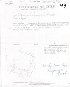 Ringwood and District Historical Society
Document, Partial copy of Certificate of Title Vol 7635 Fol 096 Lot 29, 44 Sunbeam Avenue Ringwood East, Victoria
... Parish of Ringwood. Plan of Subdivision No. 12150. (undated).... and blue on the map in the margin, being Lot 29 Parish of Ringwood ...Black and white photocopied page with added notations in blue pen.Ellen Elizabeth Stanton, Married Woman of 35 Bell Street Richmond is now the Proprietor of an estate in Fee-simple, subject to the Encumbrances notified herunder in the surface down to the depth of fifty feet below the surface of the pie of land delineated and colored red purple and blue on the map in the margin, being Lot 29 Parish of Ringwood. Plan of Subdivision No. 12150. (undated). -
 Bendigo Historical Society Inc.
Document - LANDS OFFICE: CERTIFIED PLAN REGISTER
... edges. Spine has red insert with 'Certified Plan Register... page: number, date of receipt, name, parish, tracing book, plan ...Document: hard cover journal. Buff cover with embossed edges. Spine has red insert with 'Certified Plan Register' printed in gold. 250 pages, with index in front of register. LH page: number, date of receipt, name, parish, tracing book, plan, decision of Board of land and works, gazette page, name of surveyors, date of survey, sent to, date. RH page: précis of minute. Dated 1878 - 1893, includes areas in central and northern Victoria.plan register, lands office, bendigo, plans, surveyed, victoria, northern victoria -
 Bendigo Historical Society Inc.
Document - HARRY BIGGS COLLECTION: EAGLEHAWK LOGS APPEAL, (1 -3) 4/11/70 (3)26/2/69
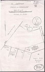
... . 1970. Item 3 - Plan of At Eaglehawk Parish of Sandhurst. Plan... of At Eaglehawk Parish of Sandhurst. Plan E 26.2.69 (reviews 22.10.69 ...Document. Harry Biggs Collection. Item 1 - An account of a meeting held in Council Chambers on 4th Nov. 1970 regarding Eaglehawk Log Lock-up on blue paper. Handwritten. Item 2 - Typed minutes on white paper Of meeting of Eaglehawk Log Lock-up committee held in Mayor's room Town Hall, Eaglehawk on 27th Aug. 1970. Item 3 - Plan of At Eaglehawk Parish of Sandhurst. Plan E 26.2.69 (reviews 22.10.69). Item 3 - 15 typed copies of the history & description of Eaglehawk Log Lock-up, also includes the cost of moving & restoring it.place, building, site, harry biggs collection, log lock-up, eaglehawk -
 Bendigo Historical Society Inc.
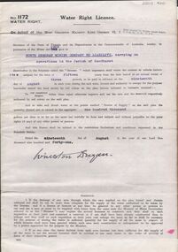
Document - MCCOLL, RANKIN AND STANISTREET COLLECTION: WATER RIGHT LICENCE NORTH DEBORAH MINING COMPANY NO LIABILITY, 19th August, 1941
... Company No Liability, Parish of Sandhurst., dated 19th August 1941... Company No Liability, Parish of Sandhurst., dated 19th August 1941 ...4 page document plus map, Water Right Licence No. 1172, between King George VI ( the Crown ) and North Deborah Mining Company No Liability, Parish of Sandhurst., dated 19th August 1941. "to take and divert water at the points marked 'source of supply' on the said plan the quantity thereof not to exceed in the aggregate one hundred thousand gallons per diem' Plan: 'Mining District of Bendigo No. 1172 W.R., County of Bendigo, Parish of Sandhurst. Plan has dam area coloured in red, with pipe line drawn in red, leading from Battery marked on lease 11145 across lease 9988 to dam. Streets marked: Adams Road, Honeybone Street, Griston Street. (Golden Square area)bendigo, mining, north deborah mining company, north deborah mining company, adams, honeybone, and griston streets. (golden square)