Showing 1235 items matching "the gap"
-
 Falls Creek Historical Society
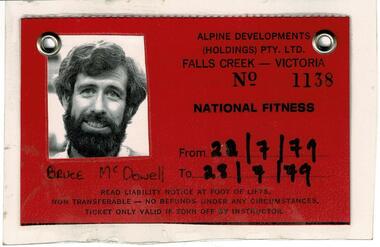
Permit Bruce McDowell 1979, 1980, 1981
SKI TICKETS Before tows and lifts were introduced at Falls Creek, it could take skiers 20 minutes to climb to the Summit … but only TWO minutes to go back to the bottom. The arrival of tows, then chairlifts and T-bars changed the face of skiing forever. The first rope tow was constructed by Toni St. Elmo for the 1951 winter season. Bob Hymans installed a smaller tow for his guests at Skyline Lodge. Tows were still quite slow, so in 1956 Bob Hymans created his single chairlift. In 1958 the Village rope tow, designed by Albury engineer Jock Wilson, opened. It was financed by shareholders including Bill Griffith (Bowna Ski Club) and the Bridgford family (St. Trinian’s Ski Club). Several other tows followed including the Summit T-bar in 1961, built by Ron McCallum and operated by Alpine Developments Pty. Ltd. which was a company formed by C. H. (Bill) Bridgford. By 1982 Falls Creek was served by 16 different lifts or T-bars, all owned and operated by Alpine Developments (Holdings) Pty. Ltd. During the development of Falls Creek, different methods have been used to pay for the use of tows, lifts and T-bars … including metal tokens, single tickets, strips of tickets and season passes. The Falls Creek Historical Society Collection includes many examples of these items.These tickets are significant because they are representative of activities at the National Fitness Camp at Falls Creek.A set of Identification cards, including a photograph, belonging to Bruce McDowell at the National Fitness Camp, Falls Creek for the years 1979, 1980, and 1981. Also included is the back of one ticket showing Conditions of use of the tickets. The National Fitness Camp at Howmans Gap was run by the Victorian State National Fitness Council. Initially the camp was leased from the State Electricity Commission (SEC). It had a capacity of 110 participants and offered both summer and winter activities.national fitness camp howmans gap, falls creek management -
 Halls Gap & Grampians Historical Society
Photograph, C 1930s
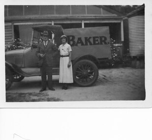
Wilfred (Fred) Warren and niece Ida Warren (who later married Robert Greer). They are shown standing in front of Warren's Bakery van, which is parked in front of their house. Warren bakery was started in 1929 by John Warren, his wife Florence, their daughter Ida and an aunt Miss Vine. see Bridging the Gap p.58A man and a woman standing in front of a truck marked "Baker.". There is a house in the background.people, warren, transport, trucks -
 Halls Gap & Grampians Historical Society
Photograph - B/W, C 1938
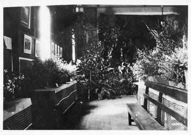
A photo taken in the Halls Gap Hall at what is said to be one of the best of the early Flower Shows of native flowers. The first flower show was held in 1933 at the suggestion of local resident Jack Watson. Four years later head teacher Grant Greenwood suggested a show be held and due to its success it continues to this day (2010).The photo shows floral displays, arranged on tables along walls and in the centre of a room. There is a bench seat in front of the table in the centre of the room (right side of the photo). Photos and paintings can be seen on the wall on the left side of the photo. "One of the first flower shows Native Flowers Ida Stanton" hand written in pen on back of phto.events, wildflower show -
 Stawell Historical Society Inc
Archive, Stawell Drama Group, Stawell Dramatic Club, 1952 - 1962
Mrs Kathy McDonald, Hall's Gap. Passed them on to our society 2008. Meeting 25-2-1952 to Reform the group 4151: Book 1: 25-2-1952 - 8 - 6 - 1954 Book 2: 12-7-1954 - 10-2-1960 Book 3: 23- 3- 1954 - 10 - 2- 1960Books 1 2 & 3 Drama/Dramatic GroupBook 1 -The Oric Series ACCOUNT BOOK (In Rectangle) MINUTE BOOK SUITABLE FOR BUSINESS. SCHOOLS & GENERAL USES Book 2 -Pink Patterned Cover. Minute Book Drama Group. (Written in pencil) Book 3 - Minute Book ( Written in ink) The Pencraft FAINT ACCOUNT BOOK A Pencraft Production ( Written in Green Print on label. Stawell Drama Group. (Written in Drama Groupstawell, clubs -
Stawell Historical Society Inc
Souvenir - Realia, Central Park 4 piece souvenir set
Souvenir Set1 Sweet Dish with waved Gold Edged top covered print Paths and Palms 15.5 cm high 19 cm wide 1 Condiment Set Missing Spoon, colour print of same 5 cm high 1 Jug with two lips, Gap between colour print of Central Park. Made in Germany 7 cm high. 1 - 3 Bud Vase with colour orint of Central Park. Made in Germany 9 cm high.tourism -
 Warrnambool and District Historical Society Inc.
Document, Leaflet Federal elections labor 2013, 2013
This is an election leaflet for Michael Barling who was a candidate in the Federal House of Representatives seat of Wannon in 2013. This electorate is in the south west of Victoria and is the second largest in the State. It includes Portland, Hamilton, Warrnambool, Ararat and Halls Gap. Michael Barling, a teacher, was an unsuccessful candidate, winning 39.9% of the primary vote. Dan Tehan won the seat and is the present Wannon representative. This leaflet is of minor interest as an example of the advertising leaflets produced by a candidate for a Federal Government electorate.This is an A4 page paper leaflet folded in three and printed on both sides with printed material, colour photographs and the Labor Party logo. Front part: ‘Michael Barling, Labor For Wannon, Australian Labor’.wannon electorate, federal house of representatives, warrnambool -
 Halls Gap & Grampians Historical Society
Photograph - Coloured, 24/04/2005
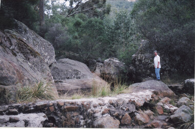
The photo shows a small weir on the Stoney Creek which used to supply water to a number of early businesses in Halls Gap. The weir's former level can be seen on the large rocks behind but once a town water supply was installed, the wall of the weir was breached. Record 247 was taken at the same time and includes an image of a description of how to get to the weir.Photograph of a woman approaching standingh on a rock near a small weir. There are large boulders behind it which show the former level of the weir.scenery, stoney creek -
 Halls Gap & Grampians Historical Society
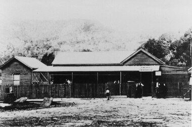
Photograph - B/W, C 1920s
The photo is of Halls Gap's first General Store, opened in 1921. The store comprised a substantial shop and residence close to today's (2009) Public Hall. The people in front of the building are the operators of the store, J. Hemley (third from right), R. Mair (fourth from right) and Mrs J. Hemley with baby (on left). The identity of the other people unknown.Photograph of a wooden (? log) building with a wooden picket fence at the front. Three people are standing in front of the building at the gate, there are a few people on the verandah of the building and a child riding past the front on a bicycle.buildings, shops -
 Halls Gap & Grampians Historical Society
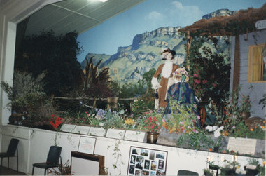
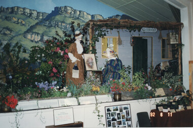
Photograph - Coloured, 06/11/1992
This display at the 1992 Wildflower Show in the Halls Gap Hall replicated the D'Alton home "Glenbower". The seated mannequin represents Henrietta D'Alton (artist) and the standing mannequin represents Ellen D'Alton. For further information about "Glenbower" and the Misses D'Alton see "Victoria's Wonderland", pp 79 & 123. ** copy is actually a second original from a slightly different angle.The photo shows a stage display - a house can be seen on the right - set up to replicate "Glenbower". Two mannequins dressed in period costume are in front of the house, one standing and one seated at a table. A flower garden has been created around the scene and a mural showing rocky peaks can be seen in the background. The front of a stage with another display and two grey chairs can be seen in the foreground."92 6 11" imprinted into bottom, right corner of photo.events, wildflower show -
 Halls Gap & Grampians Historical Society
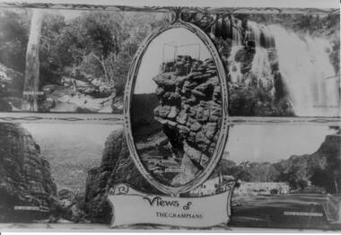
Photograph - B/W, C 1930s
The four scenes are 1) Venus Baths [top left],2) Mackenzie Falls[top right],3) The Grand Canyon[bottom left],4)Bridge and Road at Halls Gap[bottom right]. A centre view in an oval frame is The Pinnacle and a scroll with 'Views of the Grampians' written on it appearing below the frame. A scrolled frame runs top and bottom of the four scenes.Photo is a copy of a postcard, depicting four scenes in the Wonderland Range.scenery, grampians ranges -
 Halls Gap & Grampians Historical Society
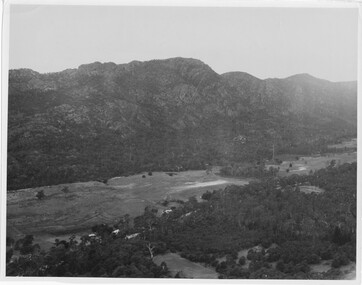
Photograph
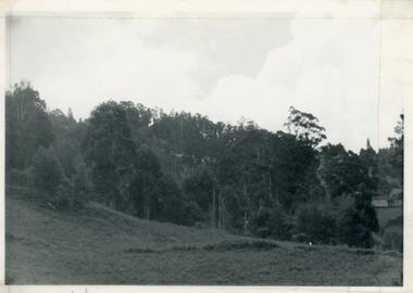
Photo depicts Fyans Valley. The road is The Grampians/ Dunkeld Road, leading to Dunkeld towards the right or Halls Gap travelling towards the left. Fyans Creek is visible in parts at the foot of the range (middle of Photo). Photo appears to have been taken from Bellfield Pk area. Photo is typical of those taken by Forests Commission of Victoria in the 1960sPhoto shows a mountain range in the background with a valley. The Valley has a band of a mostly cleared grassy section (middle of photo) with a fairly dense treed area in the foreground. A road and some buildings can be seen where the cleared land meets the treed area.scenery, fyans valley -
 Kiewa Valley Historical Society
Photograph - Folder of Photographs (KVHS 1150 A - F) – Photocopied set of black and white photographs from the display folder (pages 1 - 8) put together by KVHS to document life on the Kiewa Valley Hydro-electric Scheme
Although the Kiewa Hydro-Electric Scheme was first proposed in 1911, construction did not commence until 1938. As part of the push to cut electricity costs and diversify supply, the Victorian Government (circa 1930) initiated the conversion from primarily brown coal supply to hydro – electricity. Field investigations during the 1940’s resulted in a new proposal for a scheme that had more than double the capacity of the 1938 scheme. The Kiewa Hydroelectric Scheme became the largest scheme of its kind in the State Of Victoria and the second largest scheme in Australia. The number of personnel involved in the planning and construction of the scheme increased dramatically. During the late 1940’s, most activity centred around the construction of the West Kiewa Power Station, Rocky Valley Reservoir, McKay Creek Power Station and the Bogong Creek Aqueduct.A common thread across all the larger hydro scheme constructions was the need for workers, both qualified and unqualified who came from around the world seeking a new life for themselves and their families. New accommodation and facilities were required for the army of workers engaged in construction in often remote and wild areas. The SEC had a high demand for timber, and set up the first of a number of sawmills at Bogong Creek in 1939 and set up the first hardwood logging in the headwaters of the Kiewa River. These new ‘towns’ such as Mt Beauty and Bogong, survived, serving the needs of operational personnel and their families, and expanding with growth of new industries. Mount Beauty, and to a lesser extent Bogong, are among these places. Large A3 size spiral bound display folder containing 21 of 58 pages of photocopied black and white photographs of various aspects of the early days of the Kiewa Valley Hydro-electric scheme including equipment, various work sites and photographs of workers and their families. 1-Front page; 2-Security gate at Mt Beauty Camp; 3-Channel 1 on East Kiewa River; 4-Junction Dam – Diversion Tunnel Inlet; 5-Sawmill; 6- Homan’s Gap Sawmill; 7 Junction Dam: 8-Homan Dam Site-Diamond Drilling on River Buttress; 9- Homan Dam Site View Upstream 10-Homan Dam Investigation Camp 1-Windsor & Newton Visual Diary 60 sheet (120 pages) 11’ x 14’ 280 x 356mm 110 GSM Acid Free Drawing Paper 2-1940-Security Gate on Mt Beauty side of Kiewa River bridge. Part of old Mt Beauty camp and mess in background 3- STATE ELECTRICITY COMMISSION OF VICTORIA Date; 11.3.40 Time: 10.30am No K35 Kiewa Hydro Electric Works. Diverting East Kiewa River into Channel Page number 1 4-STATE ELECTRICITY COMMISSION OF VICTORIA Date: 5.4.40 Time: Noon No K58 Kiewa Hydro Electric Works. Junction Dam – Diversion Tunnel Inlet – Normal Flow Page number 2 5- STATE ELECTRICITY COMMISSION OF VICTORIA Date: 19.8.42 Time: 2.30pm No K883 Kiewa Hydro Electric Works. Sawmill – General View Page number 3 6- STATE ELECTRICITY COMMISSION OF VICTORIA Date: 12.1.42 Time: 2.00pm No K540 Kiewa Hydro Electric Works. Homan’s Gap Sawmill – General View Page number 4 7- STATE ELECTRICITY COMMISSION OF VICTORIA Date: 12.1.42 Time: 2.00pm No K540 Kiewa Hydro Electric Works. Junction Dam – General View looking upstream Page number 5 8- STATE ELECTRICITY COMMISSION OF VICTORIA Date: 16.11.45 Time: 10.32amm No K52153 Kiewa Hydro Electric Works Homan Dam Site – Diamond Drilling on River Buttress Page number 6 9-STATE ELECTRICITY COMMISSION OF VICTORIA Date: 15.1.45 Time: 4.10pm No K1781 Kiewa Hydro Electric Works Homan Dam Site – View Upstream Page number 7 10- STATE ELECTRICITY COMMISSION OF VICTORIA Date: 15.1.45 Time: 4.10pm No K1781 Kiewa Hydro Electric Works Homan Dam Investigation Camp 1944 – 1945 Page number 8 secv; kiewa hydro electric scheme; mt beauty; bogong; construction work; -
 Halls Gap & Grampians Historical Society
Photograph - Coloured, 06/11/1992
This display at the 1992 Wildflower Show in the Halls Gap Hall replicated the D'Alton home "Glenbower". The seated mannequin represents Henrietta D'Alton (artist) and the standing mannequin represents Ellen D'Alton. For further information about "Glenbower" and the Misses D'Alton see "Victoria's Wonderland", pp 79 & 123. ** the two copies are also originals, the third original is a slightly closer view of the display.The photo shows a stage display - a house has been set up to replicate "Glenbower". Two mannequins dressed in period costume are in front of the house, one standing and one seated at a table. A flower garden has been created around the scene and a mural showing rocky peaks can be seen in the background. The front of a stage with another display can be seen in the foreground."92 6 11" imprinted into bottom, right corner of photo.events, wildflower show -
 Coal Creek Community Park & Museum
Equipment - Ethyl Chloride
Chloroethane, commonly known by its old name ethyl chloride, is a chemical compound with chemical formula CH3CH2Cl, once widely used in producing tetraethyllead, a gasoline additive. It is a colorless, flammable gas or refrigerated liquid with a faintly sweet odor. Originally, it was proposed as a general anaesthetic, filling the gap between the weaker narcotic nitrous oxide and the more powerful drugs ether and chloroform. 8670.1 - Dark blue cardboard lid. 8670.2 - Dark Blue cardboard box. 8670.3 - Cotton ball padding. 8670.4 - Semi circle cardboard. 8670.5 - Small rectangular boxes (2) placed either side of the top of the cylinder. 8670.6 - Glass cylinder with metal fitting. 8670.7 - Paper label on cylinder.- 100 c.c./- MEDCO./- 3 1/2 fl. oz./- ETHYL CHLORIDE./- Pure./- This conforms to all the requirements of the BRITISH PHARMACOPOEIA. 1932./- LOCAL ANAESTHESIA/- MEDICINAL CHEMICALS CORPOATION LIMITED. SYDNEY. -
 Greensborough Historical Society
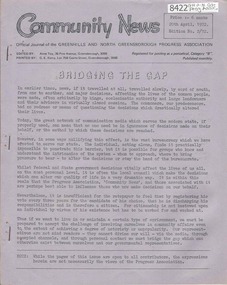
Newsletter, Greenhills and North Greensborough Progress Association, Community News: official journal of the Greenhills and North Greensborough Progress Association. 20th April, 1972. Edition No.2/72, 20/04/1972
This edition includes a report on the Progress Association's April 1972 meeting, President's report 1971-72, Bridging the gap, Facts about Lake Pedder, Yandell Reserve, Boys will the boys, Roads, The new sports complex: a view point. School and Kinder news, Local news, Diamond Valley Repertory. A digital copy of this Newsletter is available from Greensborough Historical Society.Newsletter, 18 p., illus. Printer's phone number written in red pen on cover.greenhills and north greensborough progress association, greenhills -
 Kiewa Valley Historical Society
Photograph - Folder of Photographs – Photocopied set of black and white photographs (pages 9 - 18) from the display folder put together by KVHS to document life on the Kiewa Valley Hydro-electric Scheme
Although the Kiewa Hydro-Electric Scheme was first proposed in 1911, construction did not commence until 1938. As part of the push to cut electricity costs and diversify supply, the Victorian Government (circa 1930) initiated the conversion from primarily brown coal supply to hydro – electricity. Field investigations during the 1940’s resulted in a new proposal for a scheme that had more than double the capacity of the 1938 scheme. The Kiewa Hydroelectric Scheme became the largest scheme of its kind in the State Of Victoria and the second largest scheme in Australia. The number of personnel involved in the planning and construction of the scheme increased dramatically. During the late 1940’s, most activity centred around the construction of the West Kiewa Power Station, Rocky Valley Reservoir, McKay Creek Power Station and the Bogong Creek Aqueduct.A common thread across all the larger hydro scheme constructions was the need for workers, both qualified and unqualified who came from around the world seeking a new life for themselves and their families. New accommodation and facilities were required for the army of workers engaged in construction in often remote and wild areas. The SEC had a high demand for timber, and set up the first of a number of sawmills at Bogong Creek in 1939 and set up the first hardwood logging in the headwaters of the Kiewa River. These new ‘towns’ such as Mt Beauty and Bogong, survived, serving the needs of operational personnel and their families, and expanding with growth of new industries. Mount Beauty, and to a lesser extent Bogong, are among these places. PHYSICAL: Large A3 size spiral bound display folder containing 21 pages of photocopied black and white photographs of various aspects of the early days of the Kiewa Valley Hydro-electric scheme including equipment, various work sites and photographs of workers and their families. 1-Bridge across Tailrace Channel 1946 2-New Mess building, Mt Beauty 3-Homan’s Gap Saw Mill 4- Diamond Drilling Plant – Big Hill 5-Rocky Valley Camp-Mess Building 6-Parlimentary Party at Rocky Valley 7-No.4 Headrace Tunnel 8- Allis-Chalmers Tractor School 9- SECV Heavy Machinery lined up by road 10- No. 5 Raceline – Balasting Track with improvised truck 1-1946 – Bridge across tailrace channel Page number 9 2-New mess building, Mt Beauty 6.4.46 Page number 10 3- STATE ELECTRICITY COMMISSION OF VICTORIA Date: 10.1.47 Time: 11.40am No K2271 Kiewa Hydro Electric Works Homan’s Gap Saw Mill – Rip Saw Page number 11 4- STATE ELECTRICITY COMMISSION OF VICTORIA Date: 5.10.47 Time: 11am No K4111 Kiewa Hydro Electric Works Diamond Drilling Plant – Big Hill Page number 12 5- STATE ELECTRICITY COMMISSION OF VICTORIA Date: 11.2.48 Time: 3pm No K4277 Kiewa Hydro Electric Works Rocky Valley Camp-Mess Building Page number 13 6- STATE ELECTRICITY COMMISSION OF VICTORIA Date: 15.4.48 Time: 4.30pm No K4397 Kiewa Hydro Electric Works Parlimentary Party at Rocky Valley Page number 14 7- STATE ELECTRICITY COMMISSION OF VICTORIA Date: 22.8.48 Time: 9am No K4668 Kiewa Hydro Electric Works General view of No.4 Headrace Tunnel Page number 15 8-STATE ELECTRICITY COMMISSION OF VICTORIA Date: 5.9.49 Time: 10am No K5180 Kiewa Hydro Electric Works Allis-Chalmers Tractor School – HD 19, Mr I Crossthwaite at Controls Page number 16 9- No markings Page number 17 10- STATE ELECTRICITY COMMISSION OF VICTORIA Date: 7,12.49 Time: 4pm No K5423 Kiewa Hydro Electric Works No. 5 Raceline – Balasting Track with improvised truck. Page number 18 secv; kiewa hydro electric scheme; mt beauty; bogong; construction area -
 Orbost & District Historical Society
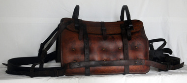
pack saddle, Early 20th century
A pack saddle is designed to be secured on the back of a horse so it can carry heavy loads. It would rest on a saddle blanket or pad to spead the the weight of the saddle. The underside of the saddle is curved to fit the shape of the animal's back. It would be symmetrically divided by a gap at the top to ensure it does not rest on the animals' backbone and to provide ventilation. This saddle was possible owned by the Forestry Department for use by fire spotters.Horses played a vital role in the agricultural and transport history of Orbost. This item is connected to that role.A large brown leather pack saddle. The underside is curved to conform to the shape of the horse's back. It is divided into two parts for weight distribution. The upper side is like a rack for the load to rest on and for it to be tied down.saddle pack-saddle equestrian -
 Halls Gap & Grampians Historical Society
Newspaper - Photocopy, 28/12/2001
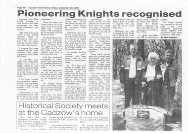
This is an article about unveiling of a plaque at the Wannon River campsite, to commemorate the Knight family and their 'Coonara" tea-rooms which opertated on that site in 1931. The photo in the article shows Ray Knight, Emma Watson and Emma's daughter standing behind the plaque. The article was written by Ida Stanton for the Stawell Times-News, 'Halls Gap Extra" and published on Friday, 28 December 2001, p.16.A photocopy of a newspaper article titled "Pioneering Knights recognised".people, knight -
 Halls Gap & Grampians Historical Society
Photograph - Coloured, 27/09/1985
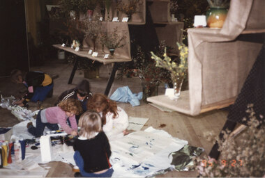
A photo taken during set-up of the Wildflower Show in 1985. The child on the left with the pink top and curly red hair is Kristy Miller (who in 2009 became a school teacher at Halls Gap Primary School). The child on the right with a white outfit and red hair tied in a ponytail is Nadia Miller (who currently, 2010, manages the Pomonal Store). The identities of the other children are unknown.The photo shows five children involved in painting activities on the floor. Stands with floral displays can be seen in the background."85 9 27" imprinted date on bottom, right of photoevents, wildflower show -
 Victorian Interpretive Projects Inc.
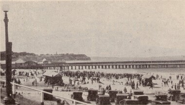
Image, Portland, 1934
The Portland Pier was extended in 1916: "The contractors for the extension or the deep-water pier continue to make steady progress, and the work is nearing completion. Only a small gap on the south end remains to be filled with piling. The beams and decking have been laid down over the whole of the rest of the pier, and the effect im presses one with the magnitude, stability and excellence of the work." (Horsham Times 23 June 1916)A number of people on the beach at Portland near the pier. A number of cars are parked in the foreground.potland, sea, -
 Flagstaff Hill Maritime Museum and Village
Bell, Before 1837
This remnant of a ships bell was recovered from the wreck site of the CHILDREN by Flagstaff Hill Divers on 1 October 1973. (Diving identification number S.M24/10-73, Accession number 24). The artefact had lain in the ocean off Childers Cove since the vessel’s disastrous sinking there on 15 January 1839. Other similarly high value metallic objects raised from the site, and now in the Flagstaff Hill collection, are the ship’s signal cannon (1963), and the ship’s anchor (1974). A ship’s bell was normally struck by the lookout at the foreward part of a vessel, following orders (“Strike the bell”) from the officer of the watch at the helm, or as a warning signal of danger ahead. Its main function was to keep the crew aware of time. Each 24 hour period was divided into 4 hour work-shifts, or watches, and each of these was divided into 8 half hours, or glasses (each half hour being determined by the time it took between each turn of the ship’s hourglass). The six watches were the first watch from 8pm to midnight, the second or middle watch from midnight to 4am, the third or morning watch from 4 to 8am, the fourth of forenoon watch from 8am to midday, the fifth or noon watch from midday to 4pm, and the sixth or dog watch from 4 to 8pm. Within each watch the first half hour would end with one bell, the second with two bells, the third with three bells, and so on until their work-shift ended with the ringing of eight bells. The CHILDREN left Launceston on 11 January 1839 and immediately struck heavy weather. By the evening of 15 January Captain Browne had been continuously on duty for 4 days and needed sleep, his First Mate (T. Gay) was incapacitated with seasickness, and the task of command was given to the Second Mate (W. Wentworth). At two bells into the first watch, or 9 o’clock that night, the captain went below. Two hours later, at six bells into the first watch, or 11 o’clock that night, the lookout cried “Breakers close ahead”. Within a minute the ship struck the rocks at the entrance of Childers Cove. Within twenty minutes the huge seas had taken her stern, three masts and much of her weatherside, leaving survivors clinging to the forecastle. Within two hours the wreck had completely disappeared. If anyone could have rung the bell by then, it would have been to strike two bells into the middle-watch, or one o’clock on the morning of 16 January. An 1859 Victorian Register of Wrecks from 1835 to 1858 remarks the CHILDREN “Ran ashore through an error in the reckoning and a bad lookout [and] Became a total wreck”. 22 passengers and crew survived the tragedy, but 16 lives were lost, including the captain and second mate, and 8 children. The shipwreck of the CHILDREN is of State significance ― Victorian Heritage Register S116A part of a brass ship’s bell, recovered from the wreck of the CHILDREN. The upper part, or dome of the bell, has corroded away, leaving the lower portion, or mouth of the bell, largely intact. However this lower surviving portion has been severed vertically with a clear (saw?) cut, leaving a regular 1cm gap down one side of the bell. It is an evocative relic, attractively aged on the seafloor, bearing layers of aqua-marine verdigris and white limestone accretion on a dull bronze surface. There is no visible ship’s name on the bell. flagstaff hill, warrnambool, shipwrecked coast, flagstaff hill maritime museum, maritime museum, shipwreck coast, flagstaff hill maritime village, great ocean road, the children, bell, ships bell, childers cove, henty brothers, james henty & co, sea-watches, nautical time, james henty & co, bell from the children -
 Mt Dandenong & District Historical Society Inc.
Photograph, View from 'Forest Edge', 1973
Photograph taken in 1973 from the property 'Forest Edge', the home of early settler George Barber. This photograph has a detailed inscription on the back handwritten by John Lundy-Clarke in 1973.Taken November 1973 by JLC. View looking from “Forest Edge” George Barber’s old home towards Price’s Lot 18. Gap on right skyline. Broadways house centre on Lot 18. Lot 25 in foreground recently cleared by Merchant Builders. Kia Ora site centre left. forest edge, george barber, price, kia ora -
 Phillip Island and District Historical Society Inc.
Photograph, Cowes Pier, Phillip Island, 1920
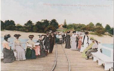
A group of twenty-two people seated and standing on the Cowes Jetty, which was built in 1870. Trolleys on iron rail were used to convey goods along the Jetty. Slightly obscured by people is the Jetty Shed, built in 1870 and now classified by National Trust. Beyond water and beach are trees and shrubs. One gap mid centre depicting The Isle of Wight Hotel - licensed in 1870 - and a large Norfolk Pine.Group waiting for ferry "Genista" on the Cowes Pier.Waiting for the Steamer on the Pier at Cowes, Phillip Islandlocal history, photographs, jetties, cowes, phillip island, colour tinted from black & white photograph, mary robb -
 Halls Gap & Grampians Historical Society
Newspaper - B/W, 26/01/2001
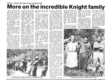
This is a newspaper article written by Ida Stanton for the Stawell Times-News "Halls Gap Extra" and published on Friday, 26 January 2001, p.18. It refers to Gus Knight and his family when they lived at Henham and on the Wannon River. The photos included in the article show: 1) a bogged vehicle being pulled out of the Wannon River by a large group of people; and 2) Gus, Ellen and Charles Knight in 1939.A newspaper article headed "More on the incredible Knight Family", containing two photos.people, knight -
 Halls Gap & Grampians Historical Society
Photograph - Coloured, C 1886
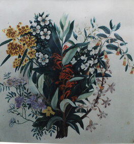
This is a photo of one of a series of wildflower paintings by Henrietta D'Alton. This is one of twelve separate original wildflower paintings mounted within one large frame (this one is the larger centre painting). Beneath the frame in its current (2010) location in the Halls Gap Hall is a plaque which reads "Henrietta D'Alton (1836-1922). This collection of wildflower water-colours won an award at the Colonial & Indian Exhibition of 1886 in London".This is a photo of a painting of a spray of flowers and leaves. There are red flowers in the centre; yellow/red "pea" flowers and white flowers on the upper left, with white, purple and one small spray of yellow flowers beneath them and white flowers and green/red "bells" on the upper right with white flowers beneath them.painting, floral -
 Bendigo Historical Society Inc.
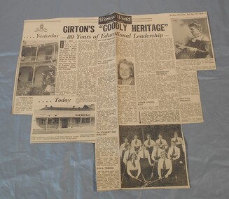
Newspaper - Lydia Chancellor collection: Girton's "goodly heritage"
In 1884 Mrs Aherne and Mrs Mrs Willward founded Girton and named it after the first residential college for women at Cambridge University in England. It was controlled by the Anglican Church. By 1992 the church could no longer afford to run the school and announce its imminent closure. A group of parents and citizens formed the "Friends of Girton" and with massive plans and fund raising they managed to reopened the school in 1993 as an independent school with no gap in classes.Bendigo Advertiser from Saturday March 28, 1964. Girton's "goodly heritage" 80 years of educational leadership.girton, education -
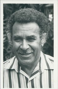 Uniting Church Archives - Synod of Victoria
Photograph, Charles Harris, 07/1988
"School at Hall's Gap studies holistic Aboriginal theology" - article by Tim Angus - "Participants at a school of Aboriginal Theology were challenged to take up a new partnership in mission by the Rev. Charles Harris, president of the Uniting Aboriginal and Islander Christian Congress… Charles Harris gave a quiet and determined witness to the power of the Gospel to free his people to become agents of their own destiny in spiritual, cultural and political terms."Head & shoulders, dressed casually."Rev. Charles Harris"harris, charles, aboriginal and islander christian congress -
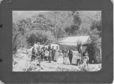 Halls Gap & Grampians Historical Society
Photograph - B/W, C 1903
The Willoughby's, Lawsons & Goodsons, camping at the base of Mackey's Peak near the child's grave. The back of the mount records that there are four Goodsons, G'dma Sarah Campbell, Aunty Thomson's Grandmother, Glad Jones (Cashin), Jim W(illoughby) nursing Mavis McAllen, Allan's Mother (not clear if Mavis McAllen is "Allan's Mother" or if Allan's Mother is another person in the photo), Clarice Willoughby, Allen W(illoughby), four Lawsons.The photo shows a large group of people (men, women and children) standing in front of a group of three tents in a clearing. The area is surrounded by bush. In the left foreground there is a cauldron hanging from a stand mad;'e of branches over a fireplace."Willoughby's camp at Halls Gap near child's grave 1903. 4 Goodsons, G'dma Sarah Campbell, Aunty Thomson's Grandmother, Glad Jones (Cashin), Jim W. nursing Mavis McAllen, Allan's Mother, Clarice Willoughby, Allen W., 4 Lawsons" hand written in blue ink on back of mount.recreation, camping -
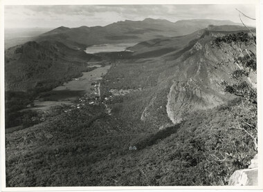 Halls Gap & Grampians Historical Society
Photograph - B/W
The photo is of the Fyans Valley, taken from Chatauqua Peak. Lake Bellfield and Mount William can be seen in the background. The photo belonged to the Forestry Commission Victoria.A photo of a valley between mountain ranges. A lake can be seen in the background. A road runs through the middle of the valley with houses on both sides."Fyans Vaslley from Chataqua Peak. Incl L. Bellfield & Halls Gap. photo belongs to F.C.V. Stawell. Return to V. Young, Horsham" written on back in green pencil. The "Chatauqua Peak" has been overwritten in black-lead pencil. "LC.71" is also written on the back in black-lead pencil.scenery, grampians ranges -
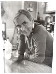 Falls Creek Historical Society
Photograph - Portrait Ory Frueauf
This photograph was taken circa 1981 - 1982 by Tourism Victoria. Orest “Ory” Frueauf was born in Kharkov, Russia in 1925 and moved to Germany with his family to escape persecution. He was conscripted to the German Army during the Second World War. He was a POW until 1948. He was recruited by a French construction company to work as and interpreter on a hydroelectricity project in Tasmania. Ory then moved to work on the Snowy Mountain Scheme including driving a truck to fill the wall of the Rocky Valley dam. In 1952 Ory was recruited by the Albury Ski Club as its lodge supervisor. That year he also entered into a business partnership with Cecil Dobson, running the general store “Whitehaven” and Post Office at Falls Creek. They extended their business by adding accommodation turning Whitehaven into one of the best commercial lodges at Falls Creek. Ory and Cecil dissolved their business partnership in 1963 and Ory went on to build a new lodge called “Snowhaven” at the site of the present day Frueauf Village, Falls Creek. The trail known as Ory's Trail is also named in his honour. Ory retired to Tawonga, Victoria in 1992 and passed away in 1999.This image is significant because it portrays a pioneer of Falls Creek.A4 size black and white photograph of Ory Frueauf standing at the bar at Snowhaven Lodge with Vovka-Finlandia VodkaOn back of photograph: Orest Freauf 1925-1997. 1925 - Born in Kharkov, Russia, 1951 Tasmania Hydro Electric Co; 1954 Howman's Gap, Kiewa Hydroelectric Scheme; 1955 Falls Creek Trading and Transport Co; 1957 Winterhaven Ski Lodge; 1963 Snowhaven Ski Lodge; 1992 Tawonga Southory freauf, hydro electric, tourism victoria, winterhaven ski lodge, snowhaven ski lodge, snow, orest frueauf