Showing 943 items
matching watt
-
 Phillip Island and District Historical Society Inc.
Photographs, Flora Miller & Catherine Walker, approx 1888
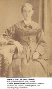
As noted under "Inscriptions)A4 photocopy of 2 portraits. One of Flora Miller and one of Catherine Walker (nee Kitty Miller) and familyFlora Miller (nee McInnis) wife of Robert Miller, early settler. In 1868 Robert Miller selected block number 21 Watts Road, Ventnor, next to Quoin Hill and the family lived there. Catherine Walker (nee Kitty Miller) photographed with three of her children around 1888. (The identity of the man and the youngest child in this photograph are unknown). Records show that Catherine's husband, James Walker, died in 1885. Her youngest child was her daughter, Flora, on left in photo.flora miller (nee mcinnis), catherine walker (nee kitty miller), robert miller, james walker, lynette carr -
 The Ed Muirhead Physics Museum
Standard Resistor Hartmann and Braun
Machined, assembled, cast, moulded. Plastic possibly stamped/painted with inscription. Handwritten in what appears to be whiteout on top circular face: ½ watt. Dymo label adhered to front: PHYSICS PT2 F2 [Stamped] inscription on top: No 2470/ HARTMANN & BRAUN/ FRANKFURT ^/M /T.C.=+0,00002/10/OHM/bei 18oC. [Stamped] inscription centred on rim of top circular face in the front: 10hm=106, 3 cm/mm2 Hg. 0 oC. Medallion on top circular face: P.T.R. 38/ 1900. Handwritten on chipped paint dot on top: “2” (?) -
 Eltham District Historical Society Inc
Slide, Maroondah Aqueduct, Research, Victoria, 22 Mar. 1981
An inspection tour of the Maroondah Aqueduct was undertaken by the Shire of Eltham Historical Society on Sunday, March 22nd, 1981, commening where the aqueduct crosses Main Rd., Research, just below Eltham College. The Maroondah Aqueduct was part of Melbourne’s water supply system. It carried water over the 66 km from the Maroondah Reservoir on the Watts River at Healesville to the Preston Reservoir. Of this length, 41 km were open channel, 10 km, tunnel through hills and 15 km in 14 inverted siphons across stream valleys. The route of the aqueduct is north of Tarrawarra and Yarra Glen, along the Yarra escarpment south of Christmas Hills and crossing Watsons Creek into the present Shire of Eltham near Henley Rd. The eastern part of the route lies entirely within the former boundaries of the shire. The aqueduct passes south of Kangaroo Ground to Research and crosses the Diamond Creek by siphon at Allendale Rd., Eltham North. It then extends to Reservoir via St. Helena, Greensborough North and Bundoora. Water first flowed through the aqueduct in February 1891 when it was fed by a diversion weir on the Watts River. Records of the building of the aqueduct indicate that it was a significant construction achievement. The present Maroondah Reservoir was completed in 1927 and the aqueduct was enlarged at that time to take increased flows. About 1971 the section of the aqueduct through and north of Research was replaced by a large pipe and that section of the channel is now unused. The channel has remained largely intact (unlike sections at Greensborough and Bundoora where long lengths of the disused aqueduct have been demolished or filled in). The M.M.B.W. relinquished control of the disused aqueduct reserve which is crown land and the Shire of Eltham took control of this section of the reserve as a linear park. The Maroondah Aqueduct is considered to be an important historic structure, not just to the local area but to the metropolitan area generally. It is considered important to preserve substantially intact long lengths of the disused aqueduct, together with its bridges and other associated structures. 35 mm colour positive transparency (1 of 5) Mount - Agfachrome Agfa CS System black 8 dotsactivities, heritage excursion, maroondah aqueduct, research (vic.), shire of eltham historical society -
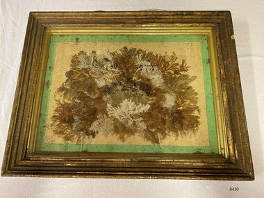 Flagstaff Hill Maritime Museum and Village
Artwork, other - Diorama with seaweed specimens, Richard Foster Norton, 1860
The diorama of mounted specimens of seaweed was framed by Richard Foster Norton for Thomas Watson and is dated 1860. Watson was the Warrnambool District Surveyor at the time (1860). The inscription on the back of the frame links the artwork to the Pigeon Hill property, which was located on Allansford Road (corner of Staffords Road – north side of the Princes Highway-A1). In the 1860s, the property known as Pigeon Hill was owned by William Wall who was a publican who ran several hotels in Warrnambool and district. In 1860 Wall, was running a hotel in Wangoom, near Pigeon Hill. Further research is required to determine the exact location, but Pigeon Hill could also have been the name for that area and may have had other people living there. Thomas Watson was a member of the local horticultural society. Another possible creator of the artwork is Samuel Hannaford, a biologist with a particular interest in collecting marine flora. Hannaford left Warrnambool in 1857 and went to Geelong, so it is possible he collected the specimens had them framed in Geelong, and then arranged for their return to Watson. The other known seaweed collector was Henry Watts, who lived in Warrnambool in the mid-19th century. The seaweed collection in this box was possibly one of Watts' and could have been prepared for the Victorian Exhibition of 1861, Richard Foster Norton, also known as R.F Norton, was one of only a handful of picture framers in 1850s Melbourne. Norton was born on the 24th of July 1822 in Yelvertoft, Northamptonshire and prior to his arrival in Australia, Norton is listed in England as having the occupation of a painter. It appears that he established his business in Melbourne in 1854 or 1855. Between 1855 and 1865 he operated from 87, then 83, and later 80 Collins Street. In the Argus newspaper, Norton advertised his business as a Print seller, Carver, Gilder and Picture Frame manufacturer, supplying the growing demand for artworks and decorative furnishings in the colony during the Gold Rush. Norton also had a Geelong branch in Market Square, where this work was produced. This framed work is highly significant. Previous research has found that only six frames are in existence that can be attributed to be made Norton, dating from the late 1850’s to the mid 1860’s. Moreover, Thomas Watson the owner of the artwork, is one of the government surveyors of the region during the mid-19th century.Diorama in deep wooden frame, behind glass. Seaweed specimens have been mounted within the frame. The back of the frame has handwritten inscriptions including the framer's label (portions missing). The diorama was framed by Richard Fraser Norton. Printed label; "RICHARD FOS --- Picture Framer and -- MANUF -- CARVER, GILDER, ---- PAINTINGS CLEANED, LINED AND --- GLASSES RESILVERED, FRAMES --- Architectual Decorations created to any design in Paper Mache, Carlton Pierre, or Composition, Country Orders promptly attended to, The Order Suppl ---, BRANCH ESTABLISHMENT, MARKET SQUARE, GEELONG" flagstaff hill, warrnambool, maritime museum, richard foster norton, r.f norton, picture framers, melbourne, geelong, artwork and decorative furnishings, gold rush, seaweed, botanical specimens, 1860, pigeon hill, district surveyor, thomas watson, william wall, wangoom, samuel hannaford, henry watts, victorian exhibition, 1861, yelvertoft, northamptonshire, market square -
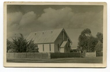
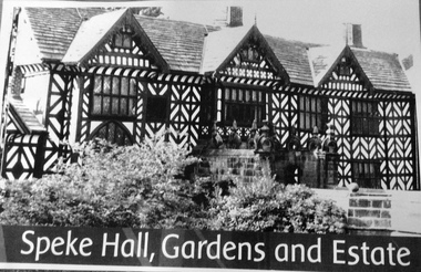 Phillip Island and District Historical Society Inc.
Photograph, Speke Hall
The ship Speke, which was wrecked in 1906 near Kitty Miller Bay, was named after the town Speke in Liverpool, where Speke Hall is located. Source http://www.nationaltrustcollections.org.uk/place/speke-hall Speke Hall This half-timbered Tudor courtyard house acquired its present shape during the 16th century under the ownership of Sir William Norris and his grandson, also Sir William. It was completed, except for some minor additions, for Edward Norris by 1606. The predominant architectural message of Speke is the decorative potential of wood. The exterior, with its high proportion of timber to infill, is a riot of geometrical patterning, while many of the Tudor interiors are filled with carved and embellished panelling – including a genealogical overmantel from c.1560 – some probably imported from the Low Countries, where the Norrises had trading connections. After a period of neglect, Speke was restored and entirely refurnished in the mid-19th century by the Watt family. 2 x Large photos of Speke Hall - 1 Black & White, 1 coloured.Speke Hall, Gardens and Estatethe speke, sailing boats, shipwrecks, photographs, speke hall -
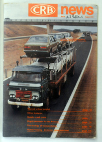 Orbost & District Historical Society
magazine, CRB News, August 1976
By 1910 it had become apparent that there was a need for a central roads authority to take over responsibility from the Board of Lands and Works for the care and management of the main roads of the state of Victoria. Because there was no consistent and systematic policy for road maintenance Victorian roads were in a deplorable condition. At this time the use of the motor car accentuated the demands for better roads. As a result of these needs the Country Roads Act 1912 was proclaimed in 1913 providing for the establishment of the Country Roads Board as a central road authority with responsibility for those roads within the State considered to be main roads. the C.R.B. was responsible for the construction of roads and bridges including the Snowy River road bridges in Orbost. This was a major project involving not only a new bridge over the Snowy River (including Lochiel Lagoon), but other bridges over Ashby’s Gulch and Watt’s Gulch. These new bridges were opened in November 1976 with the unveiling of a plaque on the eastern end of the $2.4M Snowy River Bridge. (ref. May Leatch) This is a useful reference tool on the history of the construction of the Snowy River road bridges.A journal, titled "CRB News" . On the front cover the title is in orange print with No. 33 August 1976 above a coloured photo of a truck carrying two tiers of new vehicles along a main sealed road. It contains information and photos of the construction of the Snowy River road bridges.on front cover - handwritten in black - "M. I. Gilbert"crb-news country-roads-board snowy-river-road-bridges -
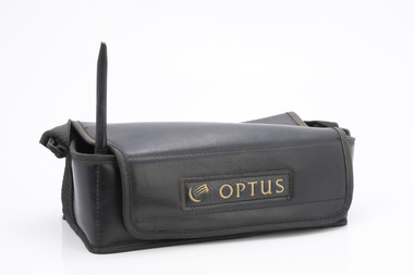 Department of Energy, Environment and Climate Action
Motorola "Bag Phone"
Motorola introduced the Bag Phone in 1988. These phones offered more durability and higher power output (up to 3 watts) than more conventional mobile phones of the time. Bag Phones were expensive to purchase and operate. They became available within the Department in the early 1990s but their use was very restricted to staff like fire communications duty officers. Senior regional managers also had bag phones. Bag Phones were also bulky and heavy and were often known as "The Brick". The 12 volt sealed lead-acid rechargeable battery provided up to 2.5 hours of talk time and 48 hours of standby time. They were replaced from the mid 1990s by smaller, analogue flip-phones with lighter Nicad batteries manufactured by companies like Nokia. The mobile phone network was patchy in country Victoria where two main telecommunications companies operated - Telstra and Optus.Motorola Bag Phone with handsetOptus 018 594 510 No battery Includes handset, aerial and 12 volt car-charger jack in vinyl bagforests commission victoria (fcv), communications -
 Eltham District Historical Society Inc
Photograph - Digital Photograph, Alan King, Maroondah Aqueduct Siphon Bridge over the Plenty River, 26 January 2008
Opened in 1891, the bridge formed part of the Maroondah Aqueduct carrying water from Watts River near Healesville to the reservoir at Preston where it joined Melbourne's metropolitan water system. Covered under Heritage Overlay, Nillumbik Planning Scheme. Published: Nillumbik Now and Then / Marguerite Marshall 2008; photographs Alan King with Marguerite Marshall.; p99 Built to supply thirsty Melbourne in the late 19th century, the siphon bridge spanning the Plenty River off Leischa Court, Greensborough, was part of an engineering masterpiece. Opened in 1891, the bridge formed part of the Maroondah Aqueduct carrying water from the Watts River near Healesville to the reservoir at Preston where it joined the metropolitan distribution system. A major link in Melbourne’s water supply, it also had a huge impact on communities, which mushroomed along its route. Named after the Aboriginal word for the area around the Maroondah Reservoir, the Maroondah Aqueduct was fully operational until the 1970s. Since the 1980s the land along parts of the aqueduct have been used for walking and bicycle riding, shaded in places by Monterey Pine trees planted to stabilise the surrounding ground. From 1857 the Yan Yean Reservoir supplied Melbourne’s water but the growing city needed additional catchments.1 In 1886 work began on a weir on the Watts River to enable the aqueduct to carry most of the river water 41 miles (66km) to Melbourne. The aqueduct, built by the Board of Works, is the oldest remaining aqueduct near Melbourne and was probably the first built with concrete.2 Although the aqueduct is now only used between the Maroondah and Sugarloaf Reservoirs, it can still be traced across the Shire. It extends from the Maroondah Reservoir through Christmas Hills, Kangaroo Ground, Research, Eltham, St Helena and then previously wound west through Greensborough to Reservoir.3 Built by horse and manpower the aqueduct gravity fed 25 million gallons (113.6ML) of water a day to Melbourne along a gradient of one foot to the mile. It included 25 miles (41km) of open concrete and brick channel, six miles (10km) of tunnels, and nine miles (15km) of 14 inverted siphons of riveted wrought-iron across creeks. Bricks for the aqueduct were made from clay found near the sites and remains of several kilns can still be found between Kangaroo Ground and Christmas Hills. Building the aqueduct transformed local communities. An abattoir was established at Christmas Hills. Grog shanties and labourers’ camps sprang up and local courts dealt with cases of ‘petty pilfering and boisterous behaviour’.4 The Kangaroo Ground school population jumped to 91, crammed into a room with one teacher. Miners who built the tunnels camped just north of Churinga in Greensborough – then called Tunnel Hill Camp – and adjacent to the Evelyn Arms Hotel. The miners’ high spirits were sometimes quenched in horse troughs or by a ‘welt under the ear and kick on the behind’ as the local constable calmed them down rather than lock them up.5 But the growing city of Melbourne needed more water, so the O’Shannassy catchment, east of Warburton, was added to the system in 1914. In 1920 work began on the present concrete Maroondah Dam one mile (1.6km) from the weir on the Watts River. The aqueduct capacity was thus doubled to 50 million gallons (227ML) a day.6 Intense land development threatened to pollute the open water supply, so channel sections were replaced with large pipes. In the late 1960s a large water main was built from the tunnel outlet at Research and extended through St Helena and Greensborough, so this section of the aqueduct was taken out of use. Long sections of the unused open channels in Greensborough and Bundoora were destroyed, but the old channel in Research and Eltham North remained largely intact. In the 1970s, the Sugarloaf Reservoir was constructed, inundating 445 hectares of land in Christmas Hills. Sugarloaf was officially opened in 1980 and serves as a water storage and treatment plant supplying Melbourne. In the early 1980s pipes replaced the section from Sugarloaf Reservoir to the tunnel entrance at Kangaroo Ground. The Research-Kangaroo Ground tunnel operates as part of the pipeline system.This collection of almost 130 photos about places and people within the Shire of Nillumbik, an urban and rural municipality in Melbourne's north, contributes to an understanding of the history of the Shire. Published in 2008 immediately prior to the Black Saturday bushfires of February 7, 2009, it documents sites that were impacted, and in some cases destroyed by the fires. It includes photographs taken especially for the publication, creating a unique time capsule representing the Shire in the early 21st century. It remains the most recent comprehenesive publication devoted to the Shire's history connecting local residents to the past. nillumbik now and then (marshall-king) collection, maroondah aqueduct, pipe bridge, siphon bridge -
Federation University Historical Collection
Image, Ballarat Teachers' College students and staff, 1947
This image was used by the Ballarat Teachers' College Class of 1947 during their reunions. black and white laminated phiotocopied photograph of men and women in front of brick building, with names typed underneath. Surnames are: Howlett, Rice, McLean, Williams, Nield, Cooper, Terrill, Gleeson, Pascoe, Harley, Carless, Giddings, Connelly, Magill, Blake, Punshon, Aisbett, Collins, O'Shannessy, Leslie, Dreher, Pamphilon, Lelean, Pattenden, Tyers, Fraser, Henderson, Mallett, martin, Boyd, Ellifson, Collins, Hill, Henning, roddis, Marshman, Doney, Watts, McKinnon, Esmore, Love, Luxford, Elliott, Bunney, Borley, Mathison, Domaschenz, Hannan, Perry, Merlin, Batson, Witney, Tozer, Kerr, Tobin, Morrish, Clode, Purdue, Kennedy, Palmer, Faulds, Ritchie, Lewin, Poland, Welsh, Lynch, Alexander, Williams, Gorris, Sonsee, Miss Kentish, Bryan, Miss Miller, Lord, Miss Hughes, McEwin, Miss Hayes, Vallance, Robinson, Surman, Gunning, Dally, Freeman, Crossettballarat teachers' college, lindsay harley, nancy cooper, david cooper, dana street primary school, alan sonsee, dana street state school -
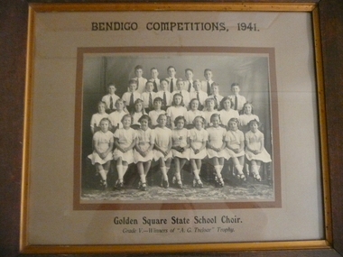 Bendigo Historical Society Inc.
Photograph - GOLDEN SQUARE SCHOOL COLLECTION: BENDIGO COMPETITIONS, 1941
Bendigo Competitions 1941, Golden Square State School Choir, Grade V winners of A.G.Treloar trophy. Black and white photograph, mixed group boys and girls in a brown timber frame, under glass with list of names attached on back. Back row: G. Whitlock, K. Wills, B. Vernon, K. Thomas, C. Sheridan. 2nd back row: K. Wilkinson, F. Crofts, C. Rance, J. Eadie, r. Purdy, L. Kent. B. Westgarth, m. Jorgenson. 2nd front row: P. griffiths, N. Iles, L. Browell, L. Bateman, D. Lewis, A. Matthews, A. Foley, L. Roberts, V. Potter. Ftont row: B. Jones, L. Westgarth, B. Mamouney, P. Laub, L. Porter, J. Cooper, R. Bull, I. Watt, M. Sullivan.Kalma Studiosbendigo, education, golden square primary school -
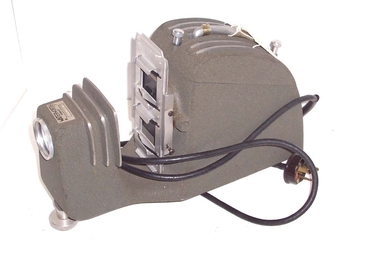 Whitehorse Historical Society Inc.
Functional object - Slide/Film Strip Projector, c1960
The donor received the projector from a relative. He used it in the City of Whitehorse and surrounding areasWaterworth Slide Film Strip Projector, Model A - 300 watt, without a fan but with ventilating slots on top and an open bottom for air to flow. It has a carrying handle and a power lead with 3 pin plug which is wired in permanently. The projector lamp is at rear under the carrying handle. Image is projected through three stage lens via via the image on the 35mm strip or slide. The front lens is adjustable for focus. A knurled nut enables a height adjustment at front. Slides are inserted through the holder - whilst one slide is shown the other can be loaded ready to be slid in front of the light. The film strip holder is missing. The unit is finished in a grey hammer finish paint used in 1960 t0 1980s. The operating instructions are filed in the supplementary envelope. The projector is stored in a hand made three ply hinged box.Waterworth Hobart 5553Aphotography, projectors -
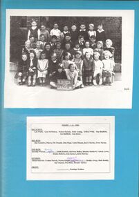 Bendigo Historical Society Inc.
Photograph - GOLDEN SQUARE LAUREL STREET P.S. COLLECTION: CLASS PHOTO
Captioned class photo laminated upon blue cardboard with students standing and seated behind blackboard reading, SS 1189, 1946, Grade 1A. Names of students enclosed upon card at later date. These read ; BACK ROW. Len Watts, Lyle McMahon, Robert Pocock, Peter Young, Jeffery Wild, Ray Banfield, Ian Sheffield, Tom Rowe. 3RD ROW. Jim Coombes, Murray Mc Donald, John Hope, Clyde Boland, Barry Hawley, Peter Hyden. 2ND ROW. Dorothy Watson, Beverly Coglan, Ruth Reddick, Barbara Bullen, Rhonda Mathews, Valerie Lewis, Donna Roberts, Jean Ipsen, Lynette Hawley. 1ST ROW. Helen Marcolo, Yvonne Pocock, Norma Knight, Sylvia Tebb, Janice Bodilly [Prep] , Ruth Bodilly, Sue Clayton, Noel Riley, Bernice Turner. FRONT. .. .. .. , Penelope Wallace.bendigo, institutions, golden square primary school -
 Phillip Island and District Historical Society Inc.
Photographs, Flora Miller & Catherine Walker (nee Miller), approx 1880's
The Millers & Walkers Phillip IslandTwo Photographs on backing sheet. 403-01: Flora Miller 403-02: Catherine Walker and family403-01: "Flora Miller (nee McInnis) Wife of Robert Miller, early settler. In 1868 Robert Miller selected block No. 21 Watts Road, Ventnor, next to Quoin Hill and the family lived there. 403-02: "Catherine Walker (nee Kitty Miller) Photographed with three of her children around 1888. (The identity of the man and the youngest child in this photograph are unknown. Records show that Catherine's husband, James Walker, died in 1885. Her youngest child was her daughter, Flora, on left in the photo).flora miller (nee mcinnis), catherine walker (nee kitty miller), james walker, robert miller, lynette carr -
 Orbost & District Historical Society
black and white photograph, Empire Post Cards, C 1940s
"The first Presbyterian Church service was conducted at the Orbost Station Homestead in 1885, during a visit by Sir William Clarke, who was accompanied by two ministers. The organist was resident Grace Jennings Carmichael. Services were later held in Mr J. W. Borland’s shop and the Mechanics Hall. In 1887, the land on which the church now stands was purchased from Mr James Hossack snr, for £50 ($100). The trustees were Mr John, Peter and Hugh Cameron, Mr John A Watt and Mr James Hossack Jnr. Timber from Richardson’s Tabbara Mill was used by builder Mr R. P. Cameron and at a cost of £311.3.7 ($622) the church was opened January 9th 1898." (from Newsletter 90 Margaret Smith) In 1928 the Sunday School hall was added to the church. Mr R.P. Cameron was the contractor for both the manse and the church. The first communion service was held on July 17 1892. the Presbyterian Church was commenced in Orbost in 1855 when the Reverend Chas Attwood was settled in pastoral charge.This is a pictorial record of the Presbyterian Church in Orbost as it was in the mid 20th century. It is now the Orbost Uniting Church hall, known as St Andrews Hall,A black /white postcard photograph of the Orbost Presbyterian Church, a wooden structure with a wooden picket fence at the front and trees on right and left sides. on back - " H Gap, Presbyterian Church Orbost"presbyterian-church-orbost religion -
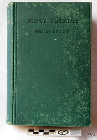 Flagstaff Hill Maritime Museum and Village
Book - Reference, William J Goudie, D. Sc., Professor (William john Goudie), Steam Turbines, 1922
This textbook was written for engineering students by Scottish Professor, William J Goudie, D. Sc., (1868-1945). He was a member of the Institution of Mechanical Engineers, a member of the Institution of Engineers and Shipbuilders in Scotland, an Associate Member of the Institution of Civil Engineers, James Watt Chair of Mechanical Engineering, University of Glasgow, and Professor of "The Theory and practice of Heat Engines" in the University of Glasgow. He wrote several papers and books on the topics of mechanical speed and power. The publisher firm, Longmans, Green & Co., was originally founded in 1724 in London by Thomas Longman under the name Longman. In August of that year, he bought the two shops and goods of William Taylor and set up his publishing house there at 39 Paternoster Row. The shops were called Black Swan and Ship, and it is said that the 'ship' sign was the inspiration for Longman's Logo. After many changes of name and management, the firm was incorporated in 1926 as Longmans, Green & Co. Pty Ltd. The firm was acquired by Pearson in 1968 and was known as Pearson Longman or Pearson PLC. The first practical steam turbine was built in 1884 by Charles Parsons and this became the beginning of generating electricity and powering large ships. The author of Steam Turbines, Professor William John Couldie D. Sc, was a mechanical engineer who had practical experience in a marine consulting engineering service and lectured in the theory and practice of mechanical engineering.This book is an example of the development of technology that contributed to the evolution of steam turbines. The book is also significant for its connection to the publisher Longmans, Green and Co., of London, a firm that has been established for over two centuries, renowned for publishing encyclopedias, dictionaries, books on English grammar, textbooks, poetry, reference books, novels, magazines and more.Steam Turbines, by William J. Goudie, D. Sc., Second edition, rewritten and enlarged. Published by Longmans, Green & Co. in 1922. The book has a textured green hardcover with a printed black title on the front cover and a gold embossed title on the spine. The fly page describes the contents. It states the author's credentials and the book's features - 329 illustrations and numerous examples.. The logo of Longmans, Green & Co. is on the fly page. It is a line drawing of a shield above a leafy wreath border surrounding a sailing ship at sea with a plaque below. Inscriptions are on the shield and plaque.On the shield: "L & Co" [Longman Green & Co.] On the plaque: "1724" [date business was established]flagstaff hill, flagstaff hill maritime museum and village, warrnambool, maritime museum, maritime village, great ocean road, shipwreck coast, steam turbines, longmans green and co, paternoster row london, ship logo, engineering studies, textbook, 1922, longmans green and co., l & co., 1724, institution of mechanical engineers, institution of engineers and shipbuilders scotland, institution of civil engineers, james watt professor of "the theory and practice of heat engines", thomas longman, paternoster row, william goudie, william j goudie, professor william j goudie d. sc., james watt chair of mechanical engineering, steam turbine, marine turbines, steam power -
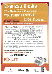 Emerging Writers' Festival
2004 Festival Program, The Melbourne Emerging Writers' Festival 2004 Program
The first Emerging Writers’ Festival was held at the Victoria Hotel in Little Collins Street in January, 2004. The inaugural festival developed out of Express Media's Make It Up zine fair. It brought together the offerings of 68 writers from across Australia in a two-day series of panels, readings, performances and workshops. Express Media ‘s Artistic Director Richard Watts was the driving force behind the ground breaking initiative that was to become the Emerging Writers’ Festival. It was clear to him through the success and the demand of the Make It Up zine fair, which had its origins in 2000, that writing and writers were in the process of radical change and needed a new environment to grow. In response, Express Media formed a partnership with the Victorian Writers’ Centre and held the first Emerging Writers’ Festival with the tagline, the best Australian writers you haven’t heard of yet. The beginnings were humble but the foundations strong. In those early years the festival found its feet, its independence and a loyal and passionate audience.An eight page, stapled program for the 2004 Emerging Writers' Festival printed in black, white and three shades of orange."Featuring the best Australian writers / you haven't heard of (yet) including new, young and / emerging poets, zinesters, short story / writers, spoken word performers, novelists, / screenplay writers / and playwrights, and a range of panels, / readings, workshops as well as an / independent publishers' trade fair."2004 emerging writers' festival, richard watts, express media, literary programming, the wheeler centre, emerging writers', literary, festival, melbourne -
Vision Australia
Text, RVIB Woodend Auxiliary, 1929 - [2000?]
The Woodend RVIB Auxiliary formed on November 8, 1929. This small collection contains index cards which were maintained by RVIB and contain the amount of donations made by the Auxiliary between 1976 - 1995 as well as the presentations delivered by RVIB employees to Auxiliary meetings between 1973 - 1985. Correspondence to and from RVIB head office ranging between 1990 - 2000. Newspaper article from 1990 'RVIB honour'; The Gisborne and Woodend auxiliaries of the RVIB have been invited to the unveiling of two plaques made in honour of the late Miss Betty Ross Watt and the late Mrs Caroline Mary Goldie at RVIB in St. Kilda Road. These ladies were foundation members of the Gisborne and Woodend auxiliaries respectively, and they worked hard and inspired others for over 50 years. As a result of their generous bequest to the institute, four sound-proofed recording studios have been completed. Other funds donated by the two women have been used for the extensions of the RVIB talking book library building and additions to library facilities. Letters -- newspaper clippings -- index cards and various loose papers royal victorian institute for the blind -
 Vision Australia
Photograph - Image, Canberra Shield : Indoor Bias Bowls for the Blind National Championships
A brown wooden award depicting a relief of an award with an image of black and white lawn bowls and a white jack on a green background. At the top of the board is an engraved plate that reads "Canberra Shield Indoor Bias Bowls for the Blind National Championships" with separate scroll work images of flowers and ferns at the top left and right hand edges. The relief sits in front of the top plate, whilst underneath are individual engraved plates for each years winners, with six plates not completed. At the base, in the middle, is another larger plate with the inscription "Most Outstanding Individual Performance". The 11 winners were inscribed "Most Outstanding Performance" with their name and year and sometimes their state. These were: 1984 Ivan Molloy, 1985 Judy Watts, 1986 Fay Williams, 1987 W. Fisher S.A., 1988 M. Cumming S.A., 1989 Betty Coleclough QLD, 1990 I. Molloy VIC, 1992 B. Brown QLD, 1994 Betty Coleclough QLD, 1996 A. Horner S.A., 1998 Ken Curtis, NSW".Wooden rectangle with metal plaques and image of lawn bowls in trophy topper that is wedged into boardawards, ivan molloy, judy watts, fay williams, w.fisher, m. cumming, betty coleclough, b. brown, a. horner, ken curtis, recreation -
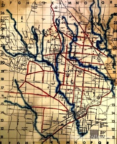 Melton City Libraries
Map, Mount Cottrell Fire group, Unknown
"In 1966, the Mount Cottrell Fire Brigades Group was formed as a way of consolidating the smaller groups around Melton, Rockbank, Toolern Vale, Sydenham, Truganina and Werribee. Its headquarters were established at the home of Ernest ‘Bon’ and Edna Barrie in Ferris Road, Melton. Captain Bon Barrie was a member of the Melton Fire Brigade and elected group and communications officer of the new Mount Cottrell Brigades Group". Fire Brigade Meeting 14th September held at Rockbank Formation a new Group in Region 14 Present: R/O H Rothsay, Assistant R/O R Orchard Tru? G Summerton Purpose of Group The pooling of the equipment in the area should be co-ordinated under one leader. The Brigade and private equipment should be co-ordinated under one leader. Formation was carried unanimously. To be called Mt Cotterill Group. Rockbank nominated Captain E W Barrie elected, Secretary K Watt Toolern Vale. Names listed C/O K L McNaughton Anakie Group COO/O R B Chirnside Lieut J Richmond Capt E Gillespie Toolern Vale Eddie L/ T S Atkin Stan L/T B Storey Bert Sec K Watt Keith Capt E W Barrie Melton Bon L/T K Gillespie Keith A Gillespie Arthur L/T G Lunson George L/T J Robinson Jeff Capt A Marquand Truganina Alan L/T I Cowie Ian Sec T Gard Tom Capt G Harrison Rockbank a/ps G Harrison N Harrison N Fisher a/ps S Hirt Melton Steve Pres M Chomley Sydenham Capt S Hughes Stan Capt L Waterson Werribee Lex Res/o J Hanson G/O S Cooper Bacchus Marsh Syd P/GO W Lidgett Wal Pro/O D Dunton G/O T Healy R C [Mt Macedon] Tom Reg Sec G Douglas Hand written notes of Edna Barrie Typed by Wendy Barrie Maps of the Mt Cottrell Fire groupemergency services, maps -
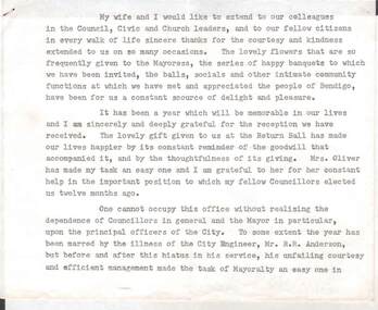 Bendigo Historical Society Inc.
Document - NORMAN OLIVER COLLECTION: MAYORAL RETIREMENT SPEECH, UNDATED
The Norman Oliver collection. Norman Oliver was three times Mayor of Bendigo - 1950-51, 1964-65, 1970-71. Six typed pages, stapled, undated. Mentions that his successor as Mayor will be Cr Turner. R. F. (Dick) Turner was Mayor 1965-66. Individuals mentioned in this speech : Mr R. R. Anderson (City Engineer), Mr H. A. Moors (Bendigo Sewerage Authority), Mr A. J. Watts (Town Clerk) and wife, Miss B. Liddell (staff), Douglas Anderson (Victorian Promotion Committee), Mr Sidney Morrell (New York), Mr Brian Harrison (MP of London), Sir Norman Martin (Victorian Inland Meat Authority), Mr Evans (Department of Immigration), Lindsay Thompson (MLC and Minister of Housing). Mr Sid Mellis and Mr J. Jeffrey, both retired Hargreaves St businessmen, have been associated with the Mayor's Blanket Appeal.bendigo, council, speech notes, norman joseph oliver , councillor norman oliver. mayor of bendigo. victorian promotion committee. victorian inland meat authority. mayor's blanket appeal. -
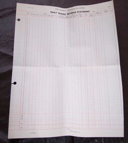 Ballarat Tramway Museum
Document - Form/s, State Electricity Commission of Victoria (SECV), "Daily Traffic Revenue Statement", 1966
3054 - Printed form titled "Daily Traffic Revenue Statement" of the SEC, Electricity Supply Department, Provincial Tramways, on off white heavy duty paper. Gives value of tickets up to 15c, , scholar and parcel tickets, special trams, value of tickets issues, cash paid in by conductor, value of tickets collected, surplus or deficiency and hospital vouchers and Outfit number of either side of the form. Has space for branch, as at date, with signatures of Compiler. Form has number TRM 583-1 (OP109) , with two large holes on left hand side for holding or filing into accounts books. Form ruled in blue ink horizontally and red ink vertically with some horizontal lines. A similar form, printed only in black, without the holes also donated by Peter Watt. Has fare values up to 18c. Layout of form identical. This form has been imaged (i2) and passed onto to Bendigo Tramways.trams, tramways, tickets, accounting, conductors -
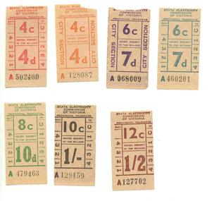 Ballarat Tramway Museum
Ephemera - Ticket/s, State Electricity Commission of Victoria (SECV), Set of 7 mixed SEC tickets ex Bendigo decimal conversion, 1966
Set of 7 mixed SEC tickets ex Bendigo decimal conversion tickets or dual currency, donated by Peter. W. Watt. Tickets do not appear to have been used in traffic - no punch marks. Tickets have not been individually numbered with the Registration Number, but can be identified by their ticket number and denomination. All on off white paper unless otherwise noted with a tartan style back unless noted with number printed in black ink. 4c/4d - City Section - A128087 - orange printing. 6c/7d - City Section - A068009 - purple printing. 4c/4d - A502400 - red printing. 6c/7d - A460201 - teal printing. 8c/10d - A479463 - green printing. 10c/1/- - A129159 - black printing. 12c/ 1/2 - A127702 - brown printing. See Reg Item 3985 for a sample of the 6c/7d ticket in a block. See Alan Bradley prepared scheduled of fares on SEC Systemstrams, tramways, tickets, secv, ballarat, decimal conversion -
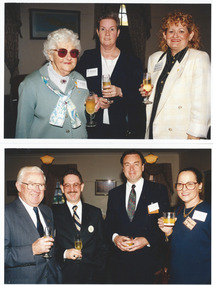 Melbourne Legacy
Photograph - Photo, Legacy Appeal, Media Launch 1998, 1998
A function at Legacy House, including a lunch. From the Post-It note it could have been the launch of Badge Week in 1998, Tom Butcher is the president. (See also 00748 and 00749). It would appear that elderly Hazel McKean is a guest of honour, she is a World War I widow. 00747.1 Legacy World War 1 widow Hazel McKean, Moira Marshall and Sarah (B?) 00747.2 Unknown, Ray Ward, Richard (?) and Betty Hardman. 00747.3 Two men and Col Bruce Amor. 00747.4 L/- Lucky Luscombe in centre with 4 guests 00747.5 Seven people seated around the table, including second from Left President Tom Butcher, centre L/- Brian Luscombe, then Peter Lawrence, Gwen Watt and Col Bruce Amor. 00747.6 Four guests at their dining table, including on the far right is Elaine Ward. 00747.7 L/- Graham Riches, elderly guest Hazel McKean and three other unknown guests. 00747.8 President Tom Butcher making a speech in front of the "Legacy, 75th Anniversary Banner, Still Caring"A record of a function at Legacy House in 1998. Colour photo x 8 of guests at Legacy house.Printing on the back "75th anniversary, legacy promotion -
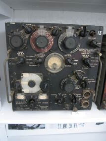
 Forests Commission Retired Personnel Association (FCRPA)
Base station radio with handset, Mid 1980s
After the 1939 bushfires, the Forests Commission invested heavily in a radically new communications network. After suffering some inevitable delays due to the War, radio VL3AA switched into full operation in October 1945 proudly beaming out 200 watts across the State. But by today’s standards, the technology was primitive and the reception poor unless the user was on a high point somewhere. The radio signal was "line-of-sight" and bounced between fire towers and relay transmitters across the mountains back to the District offices. The more secure and versatile State Mobile Radio (SMR) digital trunk system came into operation in about 1995. Upgraded Tait Radios were purchased in 2014 after recommendations of the 2009 Bushfires Royal Commission. But it was the convergence of separate technologies such as 4G mobile phones, high-capacity and light-weight lithium batteries, Wi-Fi, the ever-expanding internet, cloud data storage, digital cameras, GPS, personal organisers and hundreds of supporting Apps into powerful smartphones and tablets which revolutionised bushfire communications from the mid-2000s.Base station radio with handsetRC-4B Amalgamated Wireless Australiabushfire, radios, forests commission victoria (fcv) -
 Parks Victoria - Wilsons Promontory Lightstation
Radio
Type used by RAAF Radar station at Wilsons Promontory Lightstation (RS 14) for backup communications 1942 - 1946. This is an AT5 MF/HF 50 watts radio transmitter with black face and multiple dials and switches; There is also an AR8 radio receiver with a brown face and various dials and switches; and an AT5 radio aerial coupling unit with black face and dials and switches in the WP collection. They functioned as a set and were manufactured in 1938 at the Ashfield, Sydney workshop of AWA (Amalgamated Wireless Australasia Ltd, later AWA Ltd), Australia’s largest electronics manufacturer and broadcaster. They are rare outside Australia as they were seldom exported to other air forces, and remained in service until the late 1950s. An AT5 transmitter and AT5 coupling unit are held in Sydney’s Powerhouse Museum.The three units in the Wilsons Promontory Museum were deployed by the RAAF in WWII and represent the types of communications equipment used at the 14 Radar Station, Wilsons Promontory. It is not known, however if these particular examples were used at the lightstation and are part of the same set. They have interpretive relevance to the collection, but their significance to the lightstation is dependent on whether they have a direct historical association with the radar station that operated there. The units will have first level contributory significance if it is confirmed they were used at the Wilsons Promontory Radar Station.Radio receiver, grey metal face with multiple dials & switches -
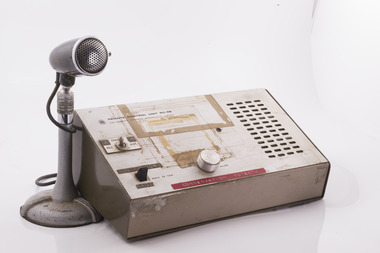
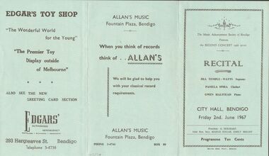 Bendigo Historical Society Inc.
Document - RECITAL, CITY HALL, BENDIGO, 2 June, 1967
A/ Recital, City Hall, Bendigo, Friday 2nd June 1967. The Music Advancement Society of Bendigo Presents the Second Concert 1967 series. Jill Temple - Watts: Soprano, Pamela Spira: Clarinet. Gwen Halstead: Piano. President: E Beilharz. Joint Hon. Secs. Madge Edgar, Emily Bright. Programme Ten Cents. Advertising: Hesse Bros. Electrical Sales, Edgar's (Toy Shop) Authorised Newsagency. Allan's Music. B/ We would like to bring to your notice an excellent programme of 'Music of Bach' presented at St. Paul's, Myer St. coming Sunday, 4th June at 3 pm. The Programme: Motet Praise the Lord, Cecilian Singers. 2 Arias Sung by Elsa Haas. Viola and Piani Sonata Played by Richard Hornung and Barbara Hyett. 2 Choral Preludes Played by Hedley Jones on the Organ. Cantata No. 104 Thou Guide of Israel. Admission by Programme, available at doors Adults 50c Children 20c.Bolton Bros. Print., Bendigoprogram, music, music advancement society bendigo, a/ recital, city hall, bendigo, 2nd june 1967. music advancement society of bendigo second concert 1967 series. jill temple - watts: soprano, pamela spira: clarinet. gwen halstead: piano. president: e beilharz. joint hon. secs. madge edgar, emily bright. programme ten cents. advertising: hesse bros. electrical sales, edgar's (toy shop) authorised newsagency. allan's music. b/ excellent programme of 'music of bach' presented at st. paul's, myer st. coming sunday, 4th june at 3 pm. the programme: motet praise the lord, cecilian singers. 2 arias sung by elsa haas. viola and piani sonata played by richard hornung and barbara hyett. 2 choral preludes played by hedley jones on the organ. cantata no. 104 thou guide of israel -
 Bendigo Historical Society Inc.
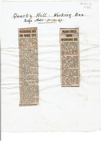
Newspaper - Quartz Hill Working Bee, 1967
Quartz Hill is situated on the Sheephead line of reef and is situated just south of where the Red, White and Blue Consolidated Gold Mine operated. Two newspaper cuttings affixed to lemon backing sheet. Written on top in black pen: 'Quartz Hill Working Bee, Bdgo Adv. 11.12.67' Cutting one, 'Working Bee on Mine Site' with 7.12.67 written across the top, describes an appeal to get volunteers to clear the site of former mines on Quartz Hill. This is anticipated to 'clear the site of accumulated debris and clean out the two large adits driven into the hill and thus make the site a 'tourist visiting spot'. Cutting two, 'Many Miss Mine Working Bee' dated 11.12.67, describes the poor response to the working bee. ' Members of the Tourist Development Association and the Town Clerk, Mr. A.J. Watts, cleared 175 feet of the Northern tunnel and cut an entrance way and steps in the Southern tunnel of the New Blue Mine area in the first stage of the mining project. Mr. J. Stanistreet said last night he was most disappointed. He said: 'apparently we picked the wrong time of the year'.mining, sandhurst, new blue consolidated gold mine, red white and blue consolidated gold mine, quartz hill, sheepshead reef line, a.j. watts, j. stanistreet, bob long