Showing 8861 items matching " construction"
-
 Melbourne Tram Museum
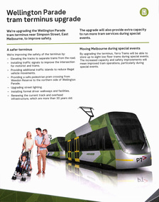
Pamphlet, Transport for Victoria, "Wellington Parade tram terminus upgrade", Nov. 2019
.1 - Pamphlet - folded A3 to A4, titled "Wellington Parade tram terminus upgrade" to provide a set of scissors cross overs a the Simpson St siding, improved safety for crews, pedestrians and for use during particularly special events. Has a map showing the extent of works, pedestrian crossings and car parks changes. Also shows two toilet blocks for crews in grey. On the rear has the dates for the drop in session. Has the PTV, Transport for Victoria and Yarra Trams logos. .2 - Pamphlet - 3 fold DL - printed on off white paper, titled "Buses replace Trams" - 25/10 to 1/11 Set of five digital images of pamphlets collected from Yarra Trams website 14-10-2020trams, tramways, wellington parade, simpson st, trackwork, construction, terminus, crossover -
 Melbourne Tram Museum
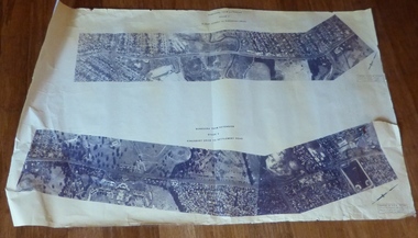
Drawing, Melbourne & Metropolitan Tramways Board (MMTB), Aerial photographs Bundoora Tram Extensions, Plenty Road – MMTB Drawings – 12/1979, Bundoora Extension – Metropolitan Transit Authority – 2/1983, John-Connell – Mott Hay and Anderson – Preliminary drawings for the Latrobe Modal Interchange – August 1984, 1979 to 1984
Set of drawings for the MMTB Plenty Road extension in 1979, MTA extension to Bundoora in 1983 and the Latrobe Uni Modal Interchange - 1984. Large print – Aerial photographs Bundoora Tram Extensions Stage 2 – Albert St to Kingsbury Drive Stage 3 – Kingsbury Drive to Settlement Road Has been rolled, left hand edge damaged, right hand edge torn Compiled by the ROW Division – 2/1981. Has written on rear at right hand end “Bundoora Tram Extension – Official MMTB Plans” 760H x 1190W Plenty Road – MMTB Drawings – 12/1979 P15123 Tyler St to Walsal Avenue P15124 Walsal Ave t McColl St P15125 McColl St to Dorrington Avenue Bundoora Extension – Metropolitan Transit Authority – 2/1983 P15400 Dorrington Avenue to Barwon Avenue P15401 Barwon Avenue to Nicholson Ave P15402 Nicholson St to Barling Park P15403 Barling Park to Darebin Creek P15404 Darebin Creek to Scott Grove P15405 Scott Grove to Clunes Street P15406 Clunes St to Cash St P15408 Cash St to Bundoora Park P15409 Bundoora Park to Larundel Hospital P15410 At Larundel Hospital P15411 Larundel Hospital to Marne Court P15412 Marne Court to Cherrywood Court P15413 Cherrywood Court to Morwell Ave P15414 Morwell Ave to Grimshaw St P15415 Grimshaw St to Nickson Street P15416 Nickson St to McLeans Road John-Connell – Mott Hay and Anderson – Preliminary drawings for the Latrobe Modal Interchange – August 1984. 8094-A-20 Set Out Plan and Paving Details 8094-A-21 Elevations 8094-A-22 Sections 8094-A-23 Roof Plan and Stormwater Layout 8094-A-24 Canopy Details 8094-A-25 Toilet Block and Waiting Room 8094-A-28 Miscellaneous DetailsOn rear of aerial photograph sheet - at right hand end “Bundoora Tram Extension – Official MMTB Plans” in felt pen.trams, tramways, plenty rd, bundoora, latrobe university, mmtb, construction, mta -
 Melbourne Tram Museum
Document - Research Notes, "The Melbourne, Brunswick & Coburg Tramways Trust", c1990
Eleven page research report titled "The Melbourne, Brunswick & Coburg Tramways Trust", giving details of the formation of the trust, the routes it constructed, opening, extensions, proposals, description, power supplies, depot, rolling stock, tramcars, passenger numbers, financial results, tickets, sections and fares, extracts from the rules and regulations, instructions for crews, destination indicators, safe working, trailers and operations. Stapled in top left hand corner.trams, tramways, mbctt, coburg, brunswick, coburg depot, construction, operations -
 Eltham District Historical Society Inc
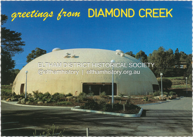
Postcard - Photograph, Nucolorvue Productions Pty Ltd, greetings from Diamond Creek, n.d
Diamond Creek Bini Shell Community venue Built in 1979 in Diamond Creek opposite the hotel using a construction method invented by Dante Bini. A net of flexible steel rods were laid on the building’s circular base, on the top of a fabric bladder. Concrete was poured onto the mesh and a sealed cover laid over the concrete making a sandwich of cover, bladder and mesh. Compressed air was pumped into the bladder and the sandwich slowly began to rise and become a massive self-supporting dome. The inflation of the dome attracted crowds of onlookers many from various technical schools, VIPs and the famous football doctor, Donald Cordner. An opening night dinner was held to celebrate the construction and the Diamond Creek Bini Shell was used as a community venue for over ten years including for the Town Fair. The Shell was closed for safety reasons after a Bini Shell in another State had chunks of concrete fall off the dome due to a construction fault. At the Diamond Creek Town Fair in 1991 the demolition of the Bini Shell was an item on the Town Fair’s program. Information: Kevin Patterson, Nillumbik Historical Societybini shell, diamond creek community centre, nu-color-vue, postcard -
 Kiewa Valley Historical Society
Papers - History of Mt Beauty State School No. 4644
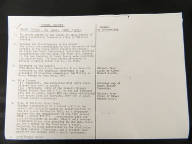
10 points of history pertaining to the History of the Mt Beauty State School which was built in 1947 as a result of the increase in student population due to the State Electricity Commission of Victoria's construction of the Kiewa Hydro Electric Scheme. Sources sited from School records and S.E.C.V records.The papers give a detailed account of the History of the Mt Beauty State School with sources sited giving accuracy to the account.Two A3 papers with typed history of the Mt Beauty State School No. 4644 with sources sited.mt beauty. state school. state electricity commission of victoria. kiewa hydro electric scheme. -
 Eltham District Historical Society Inc
Medallion, Won by G.W. Gunning, 1911; N.G.C., Presented by J.R. Hutchinson, 1911
Found during demolition of 'lean to' additions to Eltham Primary School Dalton Street building of mud stone 1875 construction during alterations, 21 September 1994. Paint appears to have dripped through onto medallion found on floor bearer 4" x 3"Round medallion, brass with paint on surfaces, approximately 25mm diameter and small eyelet at top for chain attachment or similar eltham primary school, eltham state school, g.w. gunning, j.r. hutchinson, medal, n.g.c., renovation, state school no. 209 -
![Newspaper Clipping - Digital Image, Street poll on streets 1974 [Greenhills], 24/09/1974](/media/collectors/4f729f5697f83e03086015b8/items/5eb52fca21ea671f18ffc9aa/item-media/5eb5300621ea671f18001764/item-fit-380x285.jpg) Greensborough Historical Society
Greensborough Historical SocietyNewspaper Clipping - Digital Image, Street poll on streets 1974 [Greenhills], 24/09/1974
Results of a poll conducted in 1974 by Diamond Valley Council, regarding street construction in Greenhills. Streets include: Albion Crescent, Bruce Street, Carnon Street, Cairns Street, Crest Street, Mine Street, Pembroke Street, Hope Street, Forrest Street and Hebden Street.Concerns over street construction as Greensborough moves from a semi rural to suburban area.News clipping, black and white text.shire of diamond valley, greenhills, street construction, albion crescent greensborough, carnon street greenhills -
 Glenelg Shire Council Cultural Collection
Costume - Divers suit - Siebe Gorman-Davis type 6 suit, c. 1950
Port of Portland collection. Dive suit purchased in 1952 by the Portland Harbour Trust for the purposes of constructions and demolitions of timber and steel structures at the Port. |leant to Frank Ziegler, Dive shop.| Exhibited -|Suit worn to the ball at Sea-Bath on 13 September 1997 and wrist tornFront: Siebe Gorman-Davis type 6 (on stud). Back: (no inscriptions)port of portland archives -
 Federation University Historical Collection
Document, Open House at Mt Helen for Civic Leaders, 1972, 03/1972
Ballarat Institute of Advanced Education (BIAE) was the tertiary division of the Ballarat School of Mines. The 240 acre Mt Helen campus was purchased in 1967. In 1972 a four storey library, union building and hall of residence for 70 students were under construction at an approximate cost of $2,500,000.Orange four page outline of an open house designed to give civic leaders a glimpse into the new campus at Mount Helen that was opened in 1970.ballarat institute of advanced education, mount helen campus, ballarat school of mines -
 Peterborough History Group
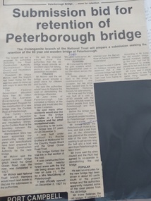
Article - Submission bid for retention of Peterborough Bridge, Cobden Times, 1985
Upon approval of the construction of the new bridge, there was a move to retain the old bridge. It was a very significant connection to the world when first built and it was hoped that all or part of the old bridge could be retained. Town meetings were held and the National Trust approached to enlist their financial support. Significant as it demonstrates the efforts by the townspeople to retain the old bridge.Three and half column newspaper article from the Cobden Times Jan 16th 1985Handwritten at the top is "Cobden Times Jan 16th 1985". With handwritten corrections of names in the article.peterborough, peterborough old bridge, curdies river bridge -
 Kew Historical Society Inc
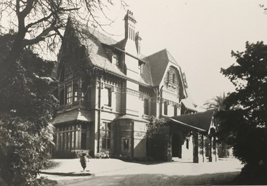
Photograph - 'Tara Hall', Studley Park Road, 1890-1900
During construction, commentators described the house as being in the ‘Elizabethan style’. The architectural style of the exterior, with its innovatory use of red brick and Italian tiles was more influenced by American models. Edward George Kilburn, of Ellerker & Kilburn, designed Byram for the industrialist George Ramsden in 1888.This is an original small photograph of this historic Kew mansion with provenance by descent from the first owners of the house.The main entrance to Tara Hall (previously named Byram, Goathland and Lowan). The entrance, through a porte-cochère, was located on the east side of the house. Inscription reverse: KH-323 Tara Hall once stood on Studley Pk Road on vast landscaped gardens. Donated by Mr Peter Ramsden, 49 Kamilaroy Road, West Pymble 2073 N.S.W. Dec.1979."byram, tara hall, lowan, goathland, edward g. kilburn (architect), george ramsden -
 Ballarat Tramway Museum
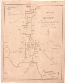
Drawing, State Electricity Commission of Victoria (SECV), "Tramways Map of Geelong", 1930s
SEC Drawing GE-T13-8802, "Tramways Map of Geelong" shewing section destinations and main places of interest along various tram routes. Undated, prior to the construction of the Beach route in 1940. See item 3469 for a larger drawing. Scanned in both colour and greyscale.Yields information about the Geelong system prior to the construction of the Beach route in 1940.Map or drawing photocopied onto heat sensitive paper - quarto size.tramways, geelong, maps, map, track layout -
 Kew Historical Society Inc
Plan, Melbourne & Metropolitan Board of Works : Borough of Kew : Detail Plan No.1302, 1910
The Melbourne and Metropolitan Board of Works (MMBW) plans were produced from the 1890s to the 1950s. They were crucial to the design and development of Melbourne's sewerage and drainage system. The plans, at a scale of 40 feet to 1 inch (1:480), provide a detailed historical record of Melbourne streetscapes and environmental features. Each plan covers one or two street blocks (roughly six streets), showing details of buildings, including garden layouts and ownership boundaries, and features such as laneways, drains, bridges, parks, municipal boundaries and other prominent landmarks as they existed at the time each plan was produced. (Source: State Library of Victoria)This plan forms part of a large group of MMBW plans and maps that was donated to the Society by the Mr Poulter, City Engineer of the City of Kew in 1989. Within this collection, thirty-five hand-coloured plans, backed with linen, are of statewide significance as they include annotations that provide details of construction materials used in buildings in the first decade of the 20th century as well as additional information about land ownership and usage. The copies in the Public Record Office Victoria and the State Library of Victoria are monochrome versions which do not denote building materials so that the maps in this collection are invaluable and unique tools for researchers and heritage consultants. A number of the plans are not held in the collection of the State Library of Victoria so they have the additional attribute of rarity.Original survey plan, issued by the MMBW to a contractor with responsibility for constructing sewers in the area identified on the plan within the Borough of Kew. The plan was at some stage hand-coloured, possibly by the contractor, but more likely by officers working in the Engineering Department of the Borough and later Town, then City of Kew. The hand-coloured sections of buildings on the plan were used to denote masonry or brick constructions (pink), weatherboard constructions (yellow), and public buildings (grey). The absence of buildings and or property in Kew facing the Yarra is the most notable feature of this plan. Walmer Street and its bridge stretched, then and now, from Studley Park Road to Victoria Street, Richmond. On the Richmond side of the Yarra, there was evidence in 1904 of industry (‘Wool shed’; Soap Works’) and entertainment (‘Skittle Alley’). In reality, another Plan (No.1303) shows Chinese Gardens bordering the Yarra on the Kew side and buildings in Young Street.melbourne and metropolitan board of works, detail plans, mmbw 1302, cartography -
 Kew Historical Society Inc
Plan, Melbourne & Metropolitan Board of Works : Borough of Kew : Detail Plan No.1575, 1905
The Melbourne and Metropolitan Board of Works (MMBW) plans were produced from the 1890s to the 1950s. They were crucial to the design and development of Melbourne's sewerage and drainage system. The plans, at a scale of 40 feet to 1 inch (1:480), provide a detailed historical record of Melbourne streetscapes and environmental features. Each plan covers one or two street blocks (roughly six streets), showing details of buildings, including garden layouts and ownership boundaries, and features such as laneways, drains, bridges, parks, municipal boundaries and other prominent landmarks as they existed at the time each plan was produced. (Source: State Library of Victoria)This plan forms part of a large group of MMBW plans and maps that was donated to the Society by the Mr Poulter, City Engineer of the City of Kew in 1989. Within this collection, thirty-five hand-coloured plans, backed with linen, are of statewide significance as they include annotations that provide details of construction materials used in buildings in the first decade of the 20th century as well as additional information about land ownership and usage. The copies in the Public Record Office Victoria and the State Library of Victoria are monochrome versions which do not denote building materials so that the maps in this collection are invaluable and unique tools for researchers and heritage consultants. A number of the plans are not held in the collection of the State Library of Victoria so they have the additional attribute of rarity.Original survey plan, issued by the MMBW to a contractor with responsibility for constructing sewers in the area identified on the plan within the Borough of Kew. The plan was at some stage hand-coloured, possibly by the contractor, but more likely by officers working in the Engineering Department of the Borough and later Town, then City of Kew. The hand-coloured sections of buildings on the plan were used to denote masonry or brick constructions (pink), weatherboard constructions (yellow), and public buildings (grey). Plan No.1575 shows that in the area bounded by Wellington Street, Edgevale Road, Glenferrie Road, and Cotham Road, there had already been significant subdivision of land and houses constructed. As one of the highest points in Kew, as expected, there were already some significant mansions built on large allotments of land. Many of these mansions are identified by name on the plan such as ‘Kelso’, ‘Abbotsford’, ‘Clarendon’ and ‘Ashlyn’ in Cotham Road. Other houses of equal size are unnamed on the plan.melbourne and metropolitan board of works, detail plans, maps - borough of kew, mmbw 1575, cartography -
 Melbourne Tram Museum
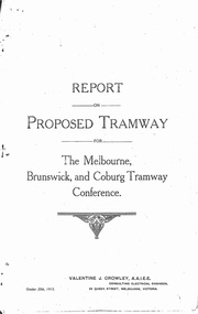
Document - Photocopy, Valentine J. Crowley Consulting Engineer, "Report on Proposed Tramway for The Melbourne, Brunswick and Coburg Tramway Conference", Original 1915
Photocopy - Report - 12 pages - titled "Report on Proposed Tramway for The Melbourne, Brunswick and Coburg Tramway Conference", prepared by Valentine J. Crowley Consulting Engineer Oct. 25, 1915. Looks at the construction of a tramway Flinders St along Queen St, to Royal Park, to Sussex St and Gaffney Road, West Coburg for the Melbourne Brunswick and Coburg Tramways Trust. Looks at the route and length of track in detail, route, administration, population, construction, permanent way, overhead lines, feeders, rolling stock, timetable, capital cost, alterations to services, expenditure for year and conclusion. Has a map of the proposed route. Included with the document is a plan of the MBCTT lines, overwritten in ball point pen with street names dated Dec. 1919. Photocopy made from original documents - has been stapled along the side in three places.trams, tramways, mbctt, maps, new tramway, west coburg, queen st, royal park -
 Kiewa Valley Historical Society
Sheet 1 - nine small black and white photos. Sheet 2 - eight small black and white photographs, c 1948 and early 1950's
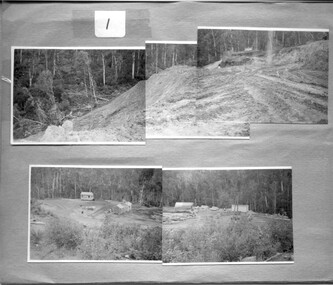
These photos are a pictorial and historical record of the early construction days of the Kiewa Scheme and a personal record of the photographer, Ronald George Thorn, of his days as an engineer with the SECV. He worked in the Kiewa area as a cadet engineer from 1948 to 1950 and then in 1953 - 56 as an electrical engineer grade 2.These photographs tell the story of one man's involvement in the construction of the Kiewa hydro electric scheme during his employment with the SECV.A foolscap sized sheet of light weight cardboard with nine small black and white photographs pasted on side 1 and eight same sized black and white photographs pasted onto side 2. The number 1 is handwritten in ink on a small square of white paper and adhered to the top of the sheet. On the other side of the sheet is number 2, handwritten in ink on white paper and adhered to the top of the sheet with sticky tape. secv, engineer, kiewa -
 Kiewa Valley Historical Society
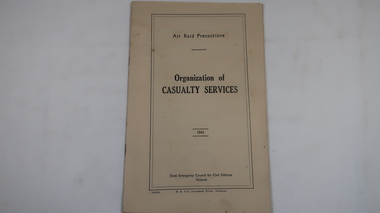
Book - Air Raid Precautions, 1941, Organisation of Casualty Services by State Emergency Council for Civil Defence Victoria
An Air Observers Hut was used by volunteers 24 / 7 at Bogong to monitor the skies for enemy aircraft during WWII. Bogong was built by the SECV during the construction of the Kiewa Hydro Electric Scheme. See also KVHS 0937 (photo), KVHS 0938 (certificate), KVHS 1259 (book)This book informed the volunteers of First Aid posts, ambulances, rescue teams etc.Cream coloured book with black print on cover. 31 pages printed on both sides and with some black & white photos. Bound by 2 staples.air raid, wwii, bogong air observers hut, khes -
 Eltham District Historical Society Inc
Document - Survey Plan, Country Roads Board, SP 6559-6560, Eltham-Yarra Glen Road; Elsa Ct to Luck St, 1957
1957 C.R.B. Plan of Survey of Part of Crown Portion 13 Section 4 and Crown Allotment 1 Section 1 Parish of Nillumbik, County of Evelyn Eltham-Yarra Glen Road, Shire of Eltham Shows Surveyor field notes, property ownership and building type and construction.eltham-yarra glen road, country roads board, eltham, main road, survey plan, 1957, a.m. & a.a. iowerson, a.mcg. hepburn, cecil street, coffee lounge, diamond street, e.g. murrell, elsa court, h.b. woodhead, j.c. & s.i. harding, la ronde, luck street, r.m. & v.m. white, r.n. mowatt, the board of land & works, w.g. hains, neil webster collection -
 Galen Catholic College
Galen Resource Centre Building Development, 2017
2017 was a busy year for building and redevelopment at Galen Catholic College. This sequence of photos shows the progressive construction of the Galen Resource Centre, which housed the new Galen Library and the IT Assistance Hub. The new Galen Library replaced the original library building that was constructed in 1972 and enlarged in 1994.galen catholic college, galen college, galen resource centre, liibrary, it office, school buildings, school grounds & buildings, 2017 -
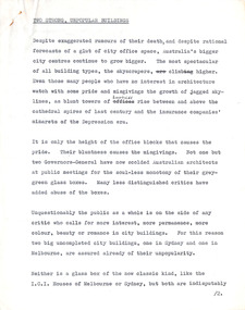 Robin Boyd Foundation
Document - Manuscript, Robin Boyd, Two Strong, Unpopular Buildings, 1964
Boyd discusses skyscrapers and the city, wondering what the next steps are after Mies Van Der Rohe's 'glass and steel'. He then considers two buildings under construction as potential answers: Harry Seidler's Pitt Street Building in Sydney and Yuncken Freeman's Royal Insurance Building.Original manuscript published as 'Something out of the Box' in 'The Australian' on 23.09.1964.Typewritten (c copy), pencil edits, quarto, 7 pagesroyal insurance building, yuncken freeman, skyscraper, mies van der rohe, harry seidler, robin boyd, manuscript -
 University of Melbourne, Burnley Campus Archives
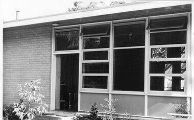
Photograph - Black and white print, Canteen & Recreation Room, 1961
Note by T.H. Kneen 19 November 1991, "Canteen & Recreation Room built by P.W.D. (Public Works Department) with funds provided by Burnley Horticultural College Ladies' Committee (in 1962?). The paving was carried out by students under direction of George Grumont." (Mechanics, Carpentry and Building Construction).Black and white photograph. Canteen and recreation room.canteen, recreation room, george grumont, burnley horticultural college ladies' committee, students working outside, public works department, paving -
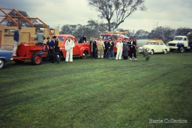 Melton City Libraries
Photograph, Shire centenary, 1962
Bon Barrie, Graeme Cooper, N. Gillespie, Peter Barrie, Ken Robinson, Ray Allen, Tom Barrie, John Roaers and Graeme Gilliland, members of the Mt Cottrell Fire Brigades Group In the background of the photo is the pavilion during construction, Melton Recreation Park on Reserve Road.Melton South Trailer tank, pump and Syd Coopers Car at the Shire centenarycouncil, local significant events, emergency services -
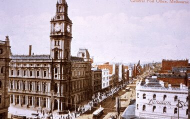 Melbourne Tram Museum
Slide - Colour - reproduction postcard - Bourke St - GPO
Reproduction slide of a hand coloured postcard showing the intersection of Bourke and Elizabeth Streets, featuring the General Post Office - GPO - looking east along Bourke St, prior to the construction of the Myer store. Has the London store on the bottom right hand side. There are cable trams in the view.Yields information about Bourke St prior to the construction of the Myer store and the GPO.Kodachrome cardboard duplicate slide - Colour - reproduction postcard - Bourke St - GPO c1900 "CB19" in penciltrams, tramways, cable cars, cable trams, bourke street, elizabeth sreet, london stores, gpo, post office, myer -
 Ballarat Tramway Museum
Letter, Ballarat Tramway Preservation Society (BTPS), BTPS Co-Operative Prospectus, 1/1972
BTPS Co-Operative Prospectus - explanatory letter and form - to raise funds for the construction of the depot - guaranteed a Government loan Jan 1972. Shareholders advanced 1/10th of the loan. The BTPS Co-op also funded the second shed extension. It was wound up during 1990/91.Yields information about the operation the BTPS Co-operative and its formation.Set of two duplicated foolscap sheets.tramways, legal matters, btps, btps co-operative -
 Ringwood and District Historical Society
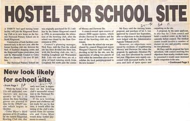
Newspaper, Scrapbook Clipping, Library Collection, Ringwood, Victoria
Newspaper Clipping from the ""Post", 24-1-96, P 1. "Hostel for school site", and P3 "New look likely for school site".A thirty bed aged nursing home facility will join the Ringwood Bowling Club at its new home on the former Norwood Primary School site in North Ringwood. Construction of both facilities commenced early in the new year, after the former bowling clib site was sold by Maroondah Council to Coles Myer on January 5 for over $5 million. -
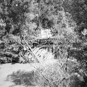 Eltham District Historical Society Inc
Negative - Photograph, J.A. McDonald, Eltham-Diamond Creek Road, 21 Sep 1959
Bridge construction Eltham-Diamond Creek road over the Diamond Creek (Wattletree Road), Eltham, September 1959 After some delay in receiving funds, work started on the bridge approaches in early September 1959. Traffic was still using the old bridge upstream. On Sunday, 20 September 1959, heavy flooding occurred in the stream and at 3:53 pm the old bridge was washed out. This photo was taken the day after. The bridge was originally built as a replacement for an older private bridge built by a man named Foley around 1880. In 1911 Heidelberg and Eltham agreed to share the costs to build a new bridge. Construction began in June 1915 and it was officially opened by Cr. Taylor on Cup Day, November 1915.Record of various Shire of Eltham infrastructure works undertaken during the period of 1952-1962 involving bridge and road reconstruction projects, sometimes with Eltham Shire Council Project Reference numbers quoted. It was during this period that a number of significant improvements were made to roads and new bridges constructed within the shire that remain in place as of present day (2022). In many situations, the photos provide a tangible visible record of infrastructure that existed throughout the early days of the Shire. The album was put together by or under the direction of the Shire Engineer, J.A. McDonald.infrastructure, shire of eltham, bridge construction, bridge, diamond creek (creek), eltham, eltham north, glen park bridge, 1959-09-21, flood damage, wattletree road bridge -
 Ballarat Tramway Museum
Photograph - Geelong Tramway relaying tracks
Relaying tram tracks at the eastern end of Aphrasia St., Newtown, looking east. The location is immediately west of the Pleasant St. intersection, soon after Aphrasia St. was extended from Pleasant St. to Pakington St. so that the three sharp curves for trams into Retreat Road, Pleasant St. and then Aphrasia St. were reduced to one, from Pakington into Aphrasia St. May 1914. Note that sleepers are being used 8in the construction. All the original tracks were laid as a "stringer" construction, as seen in items 9271 and 9214, with tie bars and continuous concrete about 50cm wide under each rail. The overhead is being worked on in two ways; safely with the horse drawn tower wagon, or less so by ladder.Black and white print on paper.GSR710/25/1/8 and 25-8, written on the reverse in pencil. The No. 1 in a circle written on reverse in ink.geelong tramway, relaying stringer tram tracks in geelong, stringer tram tracks, aphrasia st. -
 Kiewa Valley Historical Society
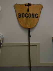
Banner - Bogong
Banners were used at schools on sports days to identify the school and/or the team. Bogong is a local town between Mt Beauty and Falls Creek and was established by the State Electricity Commission of Victoria during the construction of the Kiewa Hydro Electric Scheme. The school was opened on 28th Jan. 1941 and closed c1986. The banner probably belonged to the Bogong school and was used for sport carnivals and other events that included mixing with other schools.Wooden pole with yellow/orange satin shield cover on top. Black satin cord with tassels on top and bottom front and back. Black satin letters hand stitched on to form 'Bogong'. Fine black cord around outer edge also hand sewn.Bogongbanner; bogong state school; sport carnivals -
 Kiewa Valley Historical Society
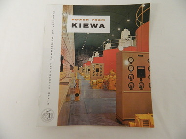
Booklet - S.E.C.V. x2, Power from Kiewa
The State Electricity Commission of Victoria constructed the Kiewa Hydro Electric Scheme. Their public relations employees published booklets to promote the Scheme and the area. In this booklet there are photos of some of the major work constructions with an explanation of how they work and their purpose, a map of the Scheme and an article and photos of tourist facilities and activities that are available.This booklet promotes the Kiewa Hydro Electric Scheme and tourism indicating that tourism was recognised as a new industry for the area. The photos give a pictorial history of the area eg. skiing using the Summit T-bar lift and includes the facilities available at the time. The explanation of the Kiewa Hydro Electric Scheme is a basic resource for students interested in Hydro power.Slim booklet with photo of McKay Creek Power Station on the front cover and the title in brown and black at the top. Printed along the spine is State Electricity Commission of Victoria.state electricity commission of victoria. kiewa hydro electric scheme. tourism. t-bar ski tow. falls creek -
 Eltham District Historical Society Inc
Photograph, Baldwin Avenue from Lilicur Road, Montmorency, c.1972, 1972c
Shire of Eltham road construction and realignment works on Baldwin Avenue, Lilicur Road and Price Avenue, Montmorency, c.1972 Sherbourne Road in distance Ref: EDHS_03875 (1972) and EDHS_04774-4 (2019) from opposite ends showing realignment of road at intersection of Sherbourne and the same Cypress tree35mm colour positive transparency blue Agfacolour Service plastic mountbaldwin avenue, infrastructure, lilicur road, montmorency, road construction, sherbourne road