Showing 7103 items matching "snowy-river"
-
 Marysville & District Historical Society
Booklet (Item) - Leisure guide, Michael Chesire & Associates Pty. Ltd, MARYSVILLE & DISTRICT LEISURE GUIDE-AUTUMN/WINTER, 1986, 1986
A free leisure guide to Marysville and the surrounding district published for Autumn and Winter, 1986. This was produced by Michael Cheshire as a free publication to promote tourism in Marysville and the surrounding district. It includes maps of the Big River Valley, Cumberland Valley, Lady Talbot Forest Drive, the Marysville area, and the township of Marysville. It was released in the autumn of 1986 and was sponsored by the Marysville Tourist & Progress Association. The Association was formed in November 1907 to promote tourism within the area. This included the physical creation of signage, parklands, roads, and walks to various attractions. A free leisure guide to Marysville and the surrounding district published for Autumn and Winter, 1986.marysville, victoria, australia, leisure guide, michael cheshire & associates pty ltd, marysville golf club, blackwood lodges, sir colin mackenzie fauna park, lake eildon, fraser national park, yarra valley wineries, marysville coach tours, kooringa, marylands guest house, lady talbot forest drive, wishing well, taggerty river recreation area, athols abbey, phantom falls, keppel falls, the beeches walking track, marylyn guest house, kufstein inn motel, the cumberland, marysville tourist & progress association, marysville newsagency & general store, crossways restaurant & motel, beauty spot walk, tree fern gully walk, michaeldene track, keppel track, woods lookout track, marysville hotel motel, lake mountain ski hire, marysville recreation and fun park, mytanta horseback safaris, upper big river valley, the big culvert, marysville mountain view horse hire, maryton park, amber view holiday lodges, cathedral restaurant, the top shop, tower motel, menzes garage, beauty spot nursery, marysville ski hire, lake mountain ski school, faraway forest, scenic motel, buxton trout farm, marysville hardware, timbertop steakhouse, marysville trout farm, healesville sanctuary, buxton hotel motel, nanda binya lodge, buxton antique and furniture mart, the black spur inn hotel, alexandra, lake mountain, geoffrey pope & associates -
 City of Moorabbin Historical Society (Operating the Box Cottage Museum)
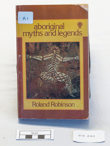
Book - Aboriginal stories, Sun Books Melbourne Pty Ltd, aboriginal myths and legends, 1967
A collection of stories of Aboriginal mythsxvi, 218 p. illus. : non-fictionA collection of stories of Aboriginal mythsaboriginal, human rights, myths, legends, robinson roland edward, australian indigenous tribes, storytellers, poetry, roper river, northern territory, sydney morning herald, the age, folk-lore, dreamtime legends, sacred songs, vesper alexander, worrell eric, naturalist, zoology, legend and dreaming -
 Dutch Australian Heritage Centre Victoria
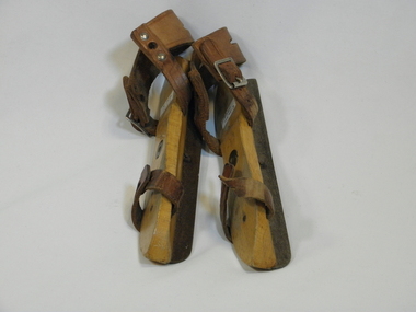
Child-size Wooden Skates, Early 20th century
Skates were and still are widely used in winter time in The Netherlands, when the rivers, canals, creeks, ponds etc. are frozen solid. Paintings out of around 1600-1700 show models of skates very much like the one shown. Even until as recent as 40 years ago, the wooden skates (with steel blade) that are tied to the shoe with leather strap and laces, were widely used in the Netherlands. Even now they are still made in children sizes, because of there flexibility in adjusting to a range of shoe sizes.Skating is a tradition which remains popular.Wooden skates, with brown leather straps. It has a metal strip on the base of the wood, which is necessary for gliding on ice.Letter R for right foot No letter for left footdutch migration skates wood -
 Dandenong/Cranbourne RSL Sub Branch
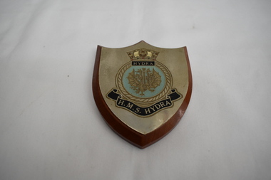
Plaque, H.M.S Hydra
Historical significance. HMS Hydra (A144) was a deep ocean hydrographic survey vessel. She was the third of 3 Hecla Class vessel's , laid down on 14th May 1964 at Yarrow Shipbuilders at Scotstoun on the River Clyde and commissioned 4th May 1966. Displacement of 2000 tons (2945 fully loaded).Length 79 Mtrs. Beam 15.4 Mtrs. Draught 4.9 mtrs. Compliment of 12 Officers and 116 crewmen. Saw operations during Falklands War. Decommissioned in 1986 and and sold to the Indonesian Navy still active as of 2019. Wooden plaque with metal plate.White sails surrounding shield over 9 headed dragon over pennant with wording H.M.S. Hydra below. -
 Kew Historical Society Inc
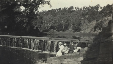
Photograph, Richardson Family at Dight's Falls, 1920
Dight’s Falls in Studley Park is an artificial weir built on a natural rock bar across the Yarra. The weir was built in the 1840s to provide water to the ‘Ceres’ flour-mill, one of the first in Victoria. The falls were later to become known as Dight’s Falls after the owners of the mill. Later, a pumping station was built on the Kew side of the river, which pumped water uphill to a reservoir in Walmer Street that provided water to the Melbourne Botanical Gardens and to Albert Park Lake. The area around Dight’s Falls was and is frequently used for recreational activities.This photograph forms part of the collection assembled by the historian Dorothy Rogers, that was donated to the Kew Historical Society by her son John Rogers in 2015. The manuscripts, photographs, maps, and documents were sourced by her from both family and local collections or produced as references for her print publications. Many were directly used by Rogers in writing ‘Lovely Old Homes of Kew’ (1961) and 'A History of Kew' (1973), or the numerous articles on local history that she produced for suburban newspapers. Most of the photographs in the collection include detailed annotations in her hand. The Rogers Collection provides a comprehensive insight into the working habits of a historian in the 1960s and 1970s. Together it forms the largest privately-donated collection within the archives of the Kew Historical Society.Black and white photograph of the Richardson family seated on the Kew side of Dight's Falls in 1920. One of the girls in the photograph was to become the Melbourne historian Dorothy (Richardson) Rogers.Annotation on reverse: "Mrs D. Rogers, 29 Park Crst Kew. Dights Falls 1920"dight's falls - kew (vic) - fairfield (vic), sport and recreation - kew (vic), dorothy rogers -
 Kew Historical Society Inc
Photograph - Yarra in Flood from Willsmere, North Kew, 1923
Flooding of the Yarra Valley, including that section of the Yarra bordering Kew and Kew East in the north and west of the municipality, was a regular occurrence. Extreme flood events of the Yarra River are recorded to have occurred in 1891, 1901, 1916, 1923 and 1934. The Municipality of Kew's response to these floods was to enact planning decisions restricting residential development in flood prone areas following the floods of 1916, 1921 and 1934. While floods continued after the development of the Upper Yarra Reservoir (construction 1948-57), the regularity and extent of these inundations diminished. Original, large sepia photograph showing men, women and children who have gathered on a grassy verge, probably farm land, to look out across the flooded Yarra Valley at Willsmere, North Kew. In the medium distance are three houses that are largely submerged by the flood waters as well as a number of Eucalypts. Judging by the clothes of the spectators, the date might be 1901 or 1916, but probably the latter due to the hats worn by a number of the women. Inscribed reverse: "Gift of Kerrie Woollard (KCC) (P)C.1923yarra river valley, kew east (vic.), floods, willsmere -
 Kew Historical Society Inc
Photograph, Colin Campbell, The Old Gum Tree, 1961
In 1871, Victoria Park, beside the Boroondara General Cemetery was set aside as a public reserve. As the Park developed, exotic plants were added to existing specimens. In 1910, a photograph of ‘The Oldest Inhabitant: A Giant Red-gum Tree’ in the Park was included in the Jubilee History of Kew. Fifty-one years later the tree was re-photographed by Colin Campbell. A 2007 Master Plan developed for the City of Boroondara advises the retention of this now dead River Red Gum, including a ‘managed risk zone’ and planting under the heavily lopped tree.‘The Old Gum Tree’ in Victoria Park. In the distance a game of cricket is being played on the oval. The old grandstand can be seen in the photo. Photographer Colin Campbell 1961. THE OLD GUM TREE / COLIN CAMPBELL KEW 1961victoria park (kew), colin campbell (photographer), victoria park, red gum tree, eucalypts, kew (vic.) -- historic trees -
 Kew Historical Society Inc
Photograph - 'Villa Alba', 44 Walmer Street, 1981
Villa Alba, a two-storeyed residence with rendered masonry walls and a slate roof, stands opposite Studley Park, overlooking the Yarra River. It is believed to have been first built before 1863, but substantially remodelled and enlarged in about 1882-83 for William Greenlaw, the Manager of the Colonial Bank of Australasia. Although the house and its tower must always have been a landmark in the area and the architecture is unusual, almost Norman in style, it is the interior which is the most remarkable feature of Villa Alba. (Source: VHD)Small black and white photographic positive of Vila Alba, 44 Walmer Street, Kew in 1981 when the original 1880s house was surrounded by hospital wards. The latter had been built by the Royal Women's Hospital after it acquired the site in 1950. The site wa Slater transferred to the Mount Royal Hospital before being purchased and converted into a museum of interior design.Verso: "Villa Alba 1981"villa alba -- 44 walmer street -- kew (vic.), mount royal hospital, henry pride wing -
![Painting, Veronica O'Hehir, [Unknown Title] by Veronica O'Hehir, pre 2000](/media/collectors/530576742162ef0fa09a2288/items/534748169821f420f8c0387a/item-media/60e66f8f463b92075d848f2e/item-fit-380x285.jpg) Federation University Art Collection
Federation University Art CollectionPainting, Veronica O'Hehir, [Unknown Title] by Veronica O'Hehir, pre 2000
Veronica O'HEHIR After graduating with a degree in fine art and a diploma in education, Veronica established herself as a practicing and exhibiting artist in Melbourne during the ‘90s-2000s. Veronica co-founded and directed RIPE gallery then later founded and directed KRAM gallery, she was also part of the Maribyrnong River Edge Arts Movement (MREAM); the studio where she met and worked alongside Faye. This item is part of the Federation University Art Collection. The Art Collection features over 2000 works and was listed as a 'Ballarat Treasure' in 2007.Framed paintingart, artwork, veronical o'hehir, flora -
!['Save Fairfield Hospital' badge, [1990s]](/media/collectors/5bb42dc221eaf31100db1d3b/items/5c9af03221ea720f88da88fb/item-media/5c9af03f21ea720f88daaa65/item-fit-380x285.jpg) Australian Nursing & Midwifery Federation
Australian Nursing & Midwifery Federation'Save Fairfield Hospital' badge, [1990s]
Fairfield Hospital opened in 1904 as the Queen's Memorial Infectious Diseases Hospital, the first purpose-built isolation hospital for infectious diseases in Victoria. Its 22-acre site was located on a bank of the Yarra River. It was renamed Fairfield Hospital in 1948. In its later years, the hospital was a centre for AIDS treatment in Victoria, and a passionate campaign fought against its planned closure in the 1990s. Fairfield Hospital finally closed in June 1996. One section of the site was gazetted as a Public Park and Memorial Garden (containing an AIDS Garden).Circular white and red plastic badge. Silver metal, plastic-coated, with safety pin fastener adhered to back. Badge printed with the red text 'SAVE FAIRFIELD HOSPITAL'. Silver metal, plastic-coated, with safety pin fastener adhered to back.medicine, health, public institutions, fairfield, victoria, city of darebin, melbourne, politics, political protest, public protest, campaigning, badges, buttons, pins, public health, infectious diseases, aids -
 Melton City Libraries
Photograph, Steve Hirst and Harry Rothsay, Unknown
Handwritten notes from Edna Barrie: In its policy of creating smaller compact groups of fire brigades the Country Fire Authority Regional Officer Harry Rothsay in 1967 requested that the following 6 brigades surrounding Mt Cottrell transfer from their respective groups. Melton and Rockbank from Bacchus Marsh Group, Toolern Vale and Sydenham from Mt Macedon Group and Truganina and Werribee from Little River Group forming a new Group to the be named Mt Cottrell Fire Brigades Group. Steve Hirst and Harry Rothsay at Melton Fire Stationlocal identities, emergency services -
 Wodonga & District Historical Society Inc
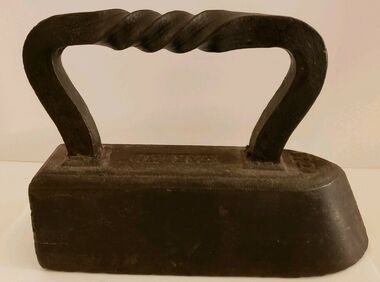
Functional object - CARRON brand Tailor's "Goose" Iron With Twist Handle, Carron Iron Company, c1850s - 1900
THE CARRON COMPANY The Carron Company established its ironworks on the banks of the River Carron in Falkirk, Stirlingshire, Scotland, in 1759, and became an incorporated company in 1773. The company was the largest ironworks in Europe during the 19th century. It supplied ammunition and armaments, steamboat engines, pig iron, cast iron goods such as flat irons, balustrades, fire grates and bath tubs, pillar boxes and telephone boxes, and even cast iron rings for underground tunnels. In 1982 it became insolvent and was taken over by the Franke Corporation, using the brand Carron Phoenix.This iron is representative of the domestic appliances used throughout Australia up until electricity became widely available for domestic use.An antique Carron iron made of solid cast iron. These types of iron were nicknamed "sad irons" from the Old English where "sad" was originally a word which meant "heavy and solid". Typically, there would be two irons simultaneously in use: one to iron with and one being heated up on the stove or in the fire. This iron has a flat bottom and back and it curves to a point at the front. It has a goose neck handle which has a twist. Irons such as this were often given the name "goose" irons. Near the front of the iron on its top '11' is marked. These irons were used from the late 18th to mid 20th centuries before electricity was widely available in all areas, particularly in rural environments.On top of iron "CARRON"flat irons, domestic appliances -
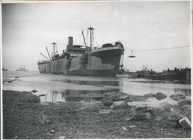 Melbourne Legacy
Photograph - Photo, Unloading supplies at Gallipoli
A photo of a boat called River Clyde unloading supplies at a beach presumed to be at the Gallipoli Peninsula. The book 'The Dardanelles' at 01886 has a photo of this boat at Seddul Bahr on page 8. Was with 11 other photos of World War One that had been mounted on board for display at Legacy House at some stage. When they were taken off display they were put in the archive cabinets. The founding legatees all served in World War One so these photos would have been of significant places for them. (see 01888 to 01899)Photos from World War One that would have been significant to the founding legatees.Black and white photo of a boat unloading at Gallipoli.gallipoli, world war one, ship -
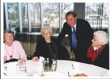 Melbourne Legacy
Photograph - Photo, Widows Lunch 2008, 2008
Photos of Legacy Widows at a luncheon function presumably after the Widows Sunday ceremony at the Shrine and a church. This is an annual event for Legacy widows at the start of Legacy Week, which is the first week in September. the day is referred to a Widows' Sunday or pilgrimage to the Shrine. The venue for lunch in these photos is Zinc in Federation Square overlooking the Yarra River. 00775.1 Melbourne Mayor John So is seen speaking to some of ladies. Names unknown. 00775.2 David Cull from Legacy on right with other guests, one is Steve Box(?) of the Probus Club of Seaford.A record of a event for the Legacy widows in 2008.Colour photo x 2 of widows lunch in 2008.Printed on the back widows, widows' sunday -
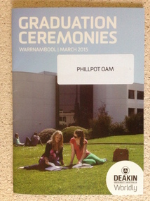 Warrnambool and District Historical Society Inc.
Booklet - Deakin University Warrnambool Graduation Ceremonies 2015, 2015
Deakin University was established in 1974 as the fourth university in Victoria. It has a number of campuses around the state including Warrnambool where it merged with The Warrnambool Institute of Advanced Education in 1990. The university was named after Alfred Deakin, three times Prime Minister of Australia and leading figure in the process of Federation in Australia. Each year a number of students graduate from the Warrnambool Campus which is located on the Eastern edge of Warrnambool on the banks of the Hopkins River. In 2015, there were graduands from the faculties of Arts and Education, Business and Law, Science and health. Deakin University occupies an important educational position In Warrnambool and district. This program contains the names of the many people associated with the university and the graduating students for the year 2015. Photograph of two students sitting on lawn in front of grey building. Text in white at top of cover.Back cover green with white text. "Phillpot OAM" on sticker on front cover. Deakin logo on bottom right corner of front cover.deakin university warrnambool, deakin university graduation 2015 -
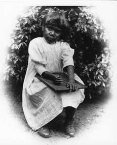 Stawell Historical Society Inc
Photograph, First Nation child at Carrs Plains
First Nation child at Carrs Plains with slate on her lap. Dressed in simple frock and laced boots. (May be linked to no. 5563-1 series in records). This photograph is a copy of the original held by Museum of Victoria. Carrs Plains was one of the early runs. Once described as a desirable spot, with the Richardson river running through it into the first level part of the country. In later years it was described as having a fascinating view of the Grampians thirty-fourth miles to the South West. To the South the Pyrenees, East the Bolangum Ranges, North limitless Plains. Black and white photograph of a young child seated holding a slate on her lap. The child is dressed in a simple frock with laced boots and seated in front of a plant. Copyright Museum of Victoriastawell aboriginal portrait -
 Surrey Hills Historical Society Collection
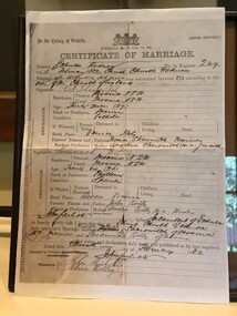
Work on paper - Vertical file, Sarovich
Christopher Joseph Sarovich married Susannah Botley. There are a number of spellings of his surname. He was involved in trade along the Murray River and they met at this time. They moved to Melbourne and the Sarovich family had a furrier family business in Port Melbourne, but resided in Surrey Hills. They owned a number of houses along Whitehorse Road, including the site of the Balwyn Community Centre. The last remaining property in family hands was sold to the Camberwell Council by Mrs Margaret (Peg) Grossman, nee Sarovich. Peg was a member of the Surrey Hills Historical Society.Vertical file of information related to members and descendants of the Sarovich (Sharowich) family: 1. Certificate of marriage of C.J. Sharowitch and Susannah Botley 11.2.1882 (1 page). NB/ Spelling as per marriage certificate. 2. Notes on Louisa Smith by June Peka 21.11.2016 (2 pages); photos of family and staff in Australia and N.Z., no dates (7 pages) and emails between June Peka and Sue Barnett 11/2016 (2 pages). 3. Margaret Grossman funeral service 28.4.2014 at St. Barnabas Anglican church, Balwyn. NB/ Margaret nee Sarovich (miss) susannah botley, (mr) christopher joseph sharowich, (mr) christopher joseph sarovich, (mrs) susannah sarovich, (miss) alice botley, (mr) john nicholls, (miss) louisa botley, (mrs) louisa smith, (mr) james smith, (miss) margaret sarovich, (mrs) margaret grossman -
 Bendigo Military Museum
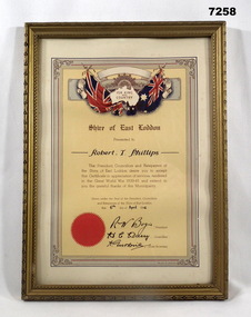
Certificate - SHIRE OF EAST LODDON, FRAMED, Arnall & Jackson, c.1940's
Certificate "FOR KING/ AND/ COUNTRY" from 'SHIRE OF EAST LODDON" "CERTIFICATE IN APPRECIATION FOR SERVICES RENDERED IN THE GREAT WORLD WAR 1939-45" "Robert T. Phillips" Robert Thomas Phillips V28869 (AMF) VX113093 (2nd AIF). Enlisted 16.12.1941 age 20 years 7 months as V28869, transferred to the AIF 14.10.1942 in 2/2nd Tank Transporter Coy ASC, listed as served in Adelaide River, Winnellie and Darwin between 25.11.1943 to 23.9.1945. Discharged 19/10/45 with the rank CPL in A.A. Pay Corps.CERTIFICATE - ORIGINAL, ON PAPER. Dark Brown print. Illustrated in colours, red, blue, yellow and beige. Top - Rising Sun Badge with British and Australian Flags, outline map of Australia and surrounded by decorative scroll work. Bottom - Red seal. Certificate framed with decorative line and scroll work. Frame - timber, gold colour paint with black paint highlights to decorate moulding. Glass front. Backing - cardboard and brown paper. Original metal hanging clips and cotton cord.Handwritten in black ink: "Robert T. Phillips" - 6th April 1946, Signed by R.W. Bogie, President. H.C....???...... Councilor, A. Gutherie Shire Secretary.framed accessories, certificate, ww2, shire of east loddon -
 Eltham District Historical Society Inc
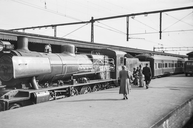
Photograph, George Coop, Steam locomotive N-430 and the Victorian Centenary Jubilee train at Spencer Street Railway Station, Feb. 1951
The Centenary-Jubilee Train. The Centenary-Jubilee train was one of the outstanding successes of the Centenary and Jubilee celebrations in Victoria. The train, attractively painted green and gold, consisted of eleven cars, and toured Victoria to take to people in the country exhibits of interest associated with the celebrations. National Art Gallery paintings, rare manuscripts and pictures were displayed, as well as models showing the history of gold production, and models and illustrations of national projects controlled by the various departments of this State. The Commonwealth section included displays by the Army, Navy, Air Force and Post Office; a war materials exhibit from the Supply Department; and diagrams and maps of the Snowy Mountains Hydro-Electric scheme. The Railways exhibit portrayed the century's growth and development of railways in Victoria and their influence on the prosperity of the State. During its 6,000 miles tour, from 1st February to 30th June, the train visited 168 stations and was inspected by 547,978 people. An entertainment unit accompanied the train and gave 100 performances which were attended by 96,400 people. Source: Report of The Victorian Railways Commissioners for the Year Ended 30th June 1951Digital TIFF file Scan of Kopdak 620 black and white negative transparencygeorge coop collection, n-430, n-class steam locomotive, victorian centenary jubilee 1951 -
 Eltham District Historical Society Inc
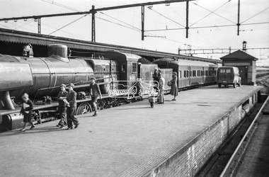
Photograph, George Coop, Steam locomotive N-430 and the Victorian Centenary Jubilee train at Spencer Street Railway Station, Feb. 1951
The Centenary-Jubilee Train. The Centenary-Jubilee train was one of the outstanding successes of the Centenary and Jubilee celebrations in Victoria. The train, attractively painted green and gold, consisted of eleven cars, and toured Victoria to take to people in the country exhibits of interest associated with the celebrations. National Art Gallery paintings, rare manuscripts and pictures were displayed, as well as models showing the history of gold production, and models and illustrations of national projects controlled by the various departments of this State. The Commonwealth section included displays by the Army, Navy, Air Force and Post Office; a war materials exhibit from the Supply Department; and diagrams and maps of the Snowy Mountains Hydro-Electric scheme. The Railways exhibit portrayed the century's growth and development of railways in Victoria and their influence on the prosperity of the State. During its 6,000 miles tour, from 1st February to 30th June, the train visited 168 stations and was inspected by 547,978 people. An entertainment unit accompanied the train and gave 100 performances which were attended by 96,400 people. Source: Report of The Victorian Railways Commissioners for the Year Ended 30th June 1951Digital TIFF file Scan of Kopdak 620 black and white negative transparencygeorge coop collection, n-430, n-class steam locomotive, victorian centenary jubilee 1951 -
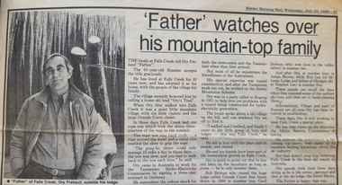 Falls Creek Historical Society
Article - "Father" watches over his mountain-top family, 30 July 1986
This article acknowledged the naming of Ory's Trail at Falls Creek in 1986. Orest “Ory” Frueauf was born in Kharkov, Russia in 1925 and moved to Germany with his family to escape persecution. He was conscripted to the German Army during the Second World War. He was a POW until 1948. He was recruited by a French construction company to work as and interpreter on a hydroelectricity project in Tasmania. Ory then moved to work on the Snowy Mountain Scheme including driving a truck to fill the wall of the Rocky Valley dam. In 1952 Ory was recruited by the Albury Ski Club as its lodge supervisor. That year he also entered into a business partnership with Cecil Dobson, running the general store “Whitehaven” and Post Office at Falls Creek. They extended their business by adding accommodation turning Whitehaven into one of the best commercial lodges at Falls Creek. Ory and Cecil dissolved their business partnership in 1963 and Ory went on to build a new lodge called “Snowhaven” at the site of the present day Frueauf Village, Falls Creek. Ory retired to Tawonga, Victoria in 1992 and passed away in 1999.This article is significant because it documents the naming of Ory's Trail to recognise a pioneer of Falls Creek.A newspaper item about Ory Freauf on the occasion of the naming of Ory's Trail at Falls Creek.falls creek pioneers, frueauf, ory frueauf -
 Wodonga & District Historical Society Inc
Functional object - Rail fish plate from Cudgewa Line, 1930 - 1960s
Cudgewa Line -The Cudgewa railway line opened in stages between 1889 and 1921. The first section from Wodonga to Huon opened on 10 September 1889. It was extended to Bolga on 18 July 1890, Tallangatta on 24 July 1891, Shelley on 13 June 1916 (the highest station in Victoria), Beetomba on 10 April 1919 and Cudgewa on 5 May 1921. The line had 1 in 30 grades and trestle bridges that have been heritage listed. In 1919, the line was used to carry materials for the construction of Hume Weir, and three years later a spur line connecting Ebden to the weir was opened. In the 1960s, Cudgewa became the railhead of materials for the Snowy Mountains Scheme. The last passenger service from Wodonga to Tallangatta ran on 30 September 1961. The turntable and passenger platform at Cudgewa were abolished in 1976. This fish plate came from the rails of the Cudgewa Line at Gordon Roy's hut which was situated behind Perry's Stump Hotel outside Wodonga. The hut was used as an office with the points lever outside to switch trucks to different tracks on the Bandiana and Cudgewa lines.This item is significant as it was part of the railway line to Cudgewa which played an important role in North east Victoria carrying freight during the construction of the Hume Weir and the Snowy Mountains Scheme.A section of flat plate. These plates were used in pairs to connect the ends of adjacent rails in railway track. victorian railways, cudgewa rail line, railway components -
 Warrnambool and District Historical Society Inc.
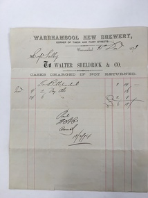
Document, Warrnambool New Brewery, 1870s
This is an invoice sent from the Warrnambool New Brewery (Walter Sheldrick & Co.) to Captain Selby. The Bill was for two dozen ales ordered on November 4th 1873 and for 6 dozen ales ordered on November 24th 1873 (cost £6-18-0). The bill was paid in February 1874. The Warrnambool New Brewery was established in 1868 by a company headed by a Warrnambool butcher and hotel proprietor, Walter Sheldrick. It was at the corner of Timor and Fairy Streets. After the first year the company was wound up and Walter Sheldrick and Thomas Price and, initially, two other partners, continued on the business. Sheldrick died in 1876 and his son Richard took over the business. By 1892 he had left the business and the brewery was operated by Edward Price, Edmund Hutton and William Trigg. In 1894 the brewery was sold and continued on until it was closed in 1922. The labels of Warrnambool Sheldricks ales had been known throughout the Western District for over 50 years. Captain Selby came to Warrnambool in the late 1860s and lived at ‘Clifton’ on the banks of the Hopkins River not far from the mouth if the river. He was a keen sportsman and was prominent in the Anglers Society, the Rowing Club (as President) and the Gun Club (pigeon shooting).As this is an original 1873 docket it is of considerable interest. It refers to the Warrnambool New Brewery, a prominent business in Warrnambool for over 50 years and to Captain Selby, well-known at the time in sporting circles. We have a good collection of other Captain Selby dockets. This is a buff-coloured piece of paper, an 1873 invoice sent from the Warrnambool New Brewery (Walter Sheldrick and Company) to Captain Selby of Warrnambool. The docket has printed red lines and both printed and handwritten material in black ink. The page has one small tear.warrnambool, walter sheldrick, captain selby, warrnambool new brewery, sheldrick ales -
 Eltham District Historical Society Inc
Photograph, Liz Pidgeon, Heritage Excursion; Eltham Lower Park Walk and Talk, 1 July 2017, 1 July 2017
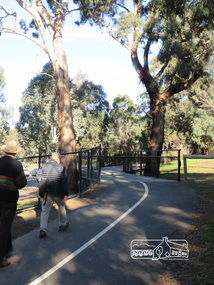
Looking towards Hohnes Road from the Diamond Creek trail in the Park. Newsletter No., 234, June 2017 Heritage Excursion - Saturday 1st July - Eltham Lower Park - Walk and Talk Eltham Lower Park has played an important part in the history of our area since the early days of European settlement when it was used by local residents as an informal racecourse. Prior to that its location at the junction of the Diamond Creek and the Yarra River made it an important meeting place for the Wurundjeri people. The park combines formal elements and sporting facilities with remnant bushland that is of environmental significance. It is home to sporting and horse riding clubs, popular play spaces and the Diamond Valley Miniature Railway, which attracts large numbers of visitors. The park will be the venue for our July excursion which will comprise a walk of about 3.5 km around the park and adjacent areas. Along the way we will discuss the history and natural history of the area. The path along the creek and the river provides a pleasant and scenic walk. This walk on Saturday 1st July is about 3.5 km in length and will take 2 to 2.5 hours. It will start at 2pm at the Main Road car park at the front of the park. (Melway ref 21 H 10). Born Digitalheritage excursion, activities, eltham district historical society, eltham lower park, hohnes road, diamond creek trail -
 Eltham District Historical Society Inc
Photograph, Liz Pidgeon, Heritage Excursion; Eltham Lower Park Walk and Talk, 1 July 2017, 1 July 2017
Walking along the shared pathway of the Diamond Creek Trail Newsletter No., 234, June 2017 Heritage Excursion - Saturday 1st July - Eltham Lower Park - Walk and Talk Eltham Lower Park has played an important part in the history of our area since the early days of European settlement when it was used by local residents as an informal racecourse. Prior to that its location at the junction of the Diamond Creek and the Yarra River made it an important meeting place for the Wurundjeri people. The park combines formal elements and sporting facilities with remnant bushland that is of environmental significance. It is home to sporting and horse riding clubs, popular play spaces and the Diamond Valley Miniature Railway, which attracts large numbers of visitors. The park will be the venue for our July excursion which will comprise a walk of about 3.5 km around the park and adjacent areas. Along the way we will discuss the history and natural history of the area. The path along the creek and the river provides a pleasant and scenic walk. This walk on Saturday 1st July is about 3.5 km in length and will take 2 to 2.5 hours. It will start at 2pm at the Main Road car park at the front of the park. (Melway ref 21 H 10). Born Digitalheritage excursion, activities, eltham district historical society, eltham lower park, walking, diamond creek trail, shared pathway -
 Eltham District Historical Society Inc
Photograph, Liz Pidgeon, Heritage Excursion; Eltham Lower Park Walk and Talk, 1 July 2017, 1 July 2017
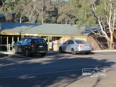
Sports pavilion with signage for Eltham Lacrosse Club and Lower Eltham Cricket Club Newsletter No., 234, June 2017 Heritage Excursion - Saturday 1st July - Eltham Lower Park - Walk and Talk Eltham Lower Park has played an important part in the history of our area since the early days of European settlement when it was used by local residents as an informal racecourse. Prior to that its location at the junction of the Diamond Creek and the Yarra River made it an important meeting place for the Wurundjeri people. The park combines formal elements and sporting facilities with remnant bushland that is of environmental significance. It is home to sporting and horse riding clubs, popular play spaces and the Diamond Valley Miniature Railway, which attracts large numbers of visitors. The park will be the venue for our July excursion which will comprise a walk of about 3.5 km around the park and adjacent areas. Along the way we will discuss the history and natural history of the area. The path along the creek and the river provides a pleasant and scenic walk. This walk on Saturday 1st July is about 3.5 km in length and will take 2 to 2.5 hours. It will start at 2pm at the Main Road car park at the front of the park. (Melway ref 21 H 10). Born Digitalheritage excursion, activities, eltham district historical society, eltham lower park, pavilion, sports pavilion, eltham lacrosse club, lower eltham cricket club, car parking -
 Eltham District Historical Society Inc
Photograph, Liz Pidgeon, Heritage Excursion; Eltham Lower Park Walk and Talk, 1 July 2017, 1 July 2017
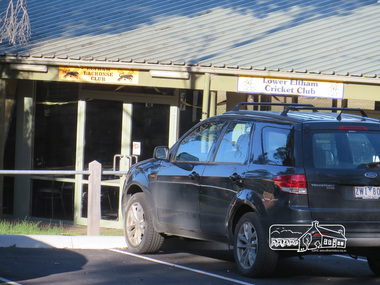
Sports pavilion with signage for Eltham Lacrosse Club and Lower Eltham Cricket Club Newsletter No., 234, June 2017 Heritage Excursion - Saturday 1st July - Eltham Lower Park - Walk and Talk Eltham Lower Park has played an important part in the history of our area since the early days of European settlement when it was used by local residents as an informal racecourse. Prior to that its location at the junction of the Diamond Creek and the Yarra River made it an important meeting place for the Wurundjeri people. The park combines formal elements and sporting facilities with remnant bushland that is of environmental significance. It is home to sporting and horse riding clubs, popular play spaces and the Diamond Valley Miniature Railway, which attracts large numbers of visitors. The park will be the venue for our July excursion which will comprise a walk of about 3.5 km around the park and adjacent areas. Along the way we will discuss the history and natural history of the area. The path along the creek and the river provides a pleasant and scenic walk. This walk on Saturday 1st July is about 3.5 km in length and will take 2 to 2.5 hours. It will start at 2pm at the Main Road car park at the front of the park. (Melway ref 21 H 10). Born Digitalheritage excursion, activities, eltham district historical society, eltham lower park, pavilion, eltham lacrosse club, eltham cricket club -
 Eltham District Historical Society Inc
Photograph, Liz Pidgeon, Heritage Excursion; Eltham Lower Park Walk and Talk, 1 July 2017, 1 July 2017
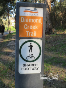
Sign produced by Shire of Nillumbik: Diamond Creek Trail shared footway Newsletter No., 234, June 2017 Heritage Excursion - Saturday 1st July - Eltham Lower Park - Walk and Talk Eltham Lower Park has played an important part in the history of our area since the early days of European settlement when it was used by local residents as an informal racecourse. Prior to that its location at the junction of the Diamond Creek and the Yarra River made it an important meeting place for the Wurundjeri people. The park combines formal elements and sporting facilities with remnant bushland that is of environmental significance. It is home to sporting and horse riding clubs, popular play spaces and the Diamond Valley Miniature Railway, which attracts large numbers of visitors. The park will be the venue for our July excursion which will comprise a walk of about 3.5 km around the park and adjacent areas. Along the way we will discuss the history and natural history of the area. The path along the creek and the river provides a pleasant and scenic walk. This walk on Saturday 1st July is about 3.5 km in length and will take 2 to 2.5 hours. It will start at 2pm at the Main Road car park at the front of the park. (Melway ref 21 H 10). Born Digitalelection day, heritage excursion, activities, eltham district historical society, eltham lower park, sign -
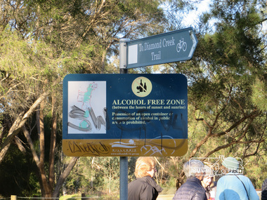 Eltham District Historical Society Inc
Photograph, Liz Pidgeon, Heritage Excursion; Eltham Lower Park Walk and Talk, 1 July 2017, 1 July 2017
Signage - To Diamond Creek Trail and Alcohol free zone Newsletter No., 234, June 2017 Heritage Excursion - Saturday 1st July - Eltham Lower Park - Walk and Talk Eltham Lower Park has played an important part in the history of our area since the early days of European settlement when it was used by local residents as an informal racecourse. Prior to that its location at the junction of the Diamond Creek and the Yarra River made it an important meeting place for the Wurundjeri people. The park combines formal elements and sporting facilities with remnant bushland that is of environmental significance. It is home to sporting and horse riding clubs, popular play spaces and the Diamond Valley Miniature Railway, which attracts large numbers of visitors. The park will be the venue for our July excursion which will comprise a walk of about 3.5 km around the park and adjacent areas. Along the way we will discuss the history and natural history of the area. The path along the creek and the river provides a pleasant and scenic walk. This walk on Saturday 1st July is about 3.5 km in length and will take 2 to 2.5 hours. It will start at 2pm at the Main Road car park at the front of the park. (Melway ref 21 H 10). Born Digitalelection day, heritage excursion, activities, eltham district historical society, eltham lower park, sign, alcohol free zone -
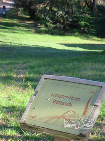 Eltham District Historical Society Inc
Photograph, Liz Pidgeon, Heritage Excursion; Eltham Lower Park Walk and Talk, 1 July 2017, 1 July 2017
Information Board - Lenister Farm Wetlands Newsletter No., 234, June 2017 Heritage Excursion - Saturday 1st July - Eltham Lower Park - Walk and Talk Eltham Lower Park has played an important part in the history of our area since the early days of European settlement when it was used by local residents as an informal racecourse. Prior to that its location at the junction of the Diamond Creek and the Yarra River made it an important meeting place for the Wurundjeri people. The park combines formal elements and sporting facilities with remnant bushland that is of environmental significance. It is home to sporting and horse riding clubs, popular play spaces and the Diamond Valley Miniature Railway, which attracts large numbers of visitors. The park will be the venue for our July excursion which will comprise a walk of about 3.5 km around the park and adjacent areas. Along the way we will discuss the history and natural history of the area. The path along the creek and the river provides a pleasant and scenic walk. This walk on Saturday 1st July is about 3.5 km in length and will take 2 to 2.5 hours. It will start at 2pm at the Main Road car park at the front of the park. (Melway ref 21 H 10). Born Digitalheritage excursion, activities, eltham district historical society, eltham lower park, information board, lenister farm