Showing 6383 items
matching Mining
-
 Flagstaff Hill Maritime Museum and Village
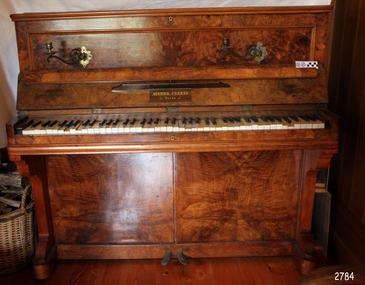
Instrument - Musical, Piano, Aucher Freres, circa 1880-1920
This piano was made by Aucher Freres of Paris, said to be famous for its pianos in the mid-late 1800s. Aucher Freres (Aucher Brothers) produced a model of piano that was built specifically for use on sailing vessels, the upright yacht-style piano. Pianos were amongst the domestic goods brought to Australia by many colonial immigrants. They were also imported by Australian distributors by the shipload and sought after by settlers. A piano was often found in a Missions to Seamen club room, where visiting seafarers would entertain or be entertained by music and song as part of their relaxation in port. A sarcastically written news article of January 2nd 1869 reported that the Secretary of the Loyal Liberals of Ballarat, Mr Henry Bell, was presented both with a “illuminated address” and a piano. The piano was made by Aucher Freres of Paris and was purchased for sixty guineas (which converts to around $7,500 Au in 2019). The gift was criticised for encouraging foreign industry rather than native Australian products, thus going against what the Loyal Liberals own protectionist policy. The writer goes on to state that several pianos made in the Colony compared very favourably at the International Exhibition with those manufactured by the English or French. He then says that “… the secretary … might learn a lesson from his piano ... the name Aucher Freres, Paris emblazoned on its front should be … a perpetual reminder of the hollowness of that protectionist imposture …” [Refer to Intercolonial News, Victoria, originally published in The Argus, was repeated in the Wallaroo Times and Mining Journal of South Australia 2-1-1869.] Aucher Freres pianos were still around in 1930. A second-hand model was advertised for sale as a good practice piano. The advertisement was placed by the Mount Gambier, SA, agents for Saver’s Pianos Ltd of Adelaide. The piano was described as “a sound little instrument of good tone and appearance”. The asking price in November 1930 was 32 pounds and ten shillings (which converts to about $2,500 Au in 2019). [Refer to Savery’s advertisement, Mt Gambier Border Watch 11-11-1930]This piano is significant for its connection with the time period of chapel and club room at Flagstaff Hill's St Nicholas Seamen's Church. It represents the form of entertainment enjoyed by seafarer's world wide, which is appropriate for a maritime village. The maker of the piano is famous for its quality pianos of the 19th and early 20th century.Piano, upright, polished wood. The wooden hinged keyboard cover lifts up to allow access to the keyboard. The piano also has two brass candlesticks. The top of the piano is hinged and lifts up to allow access to the piano mechanic's inside for tuning and maintenance. The inside flap has a music stand incorporated into it. It also has the usual two hard-soft pedals at the base. There are two brass decorated hooks at each end to allow for ease of movement when the position of the piano is changed. Maker's name inscribed inside keyboard lid in gold lettering. Made in Paris by Aucher Freres (Aucher Brothers)."AUCHER FRERES / Paris" (NOTE: the "C" is sometimes mistaken for a "G")flagstaff hill, warrnambool, shipwrecked-coast, flagstaff-hill, flagstaff-hill-maritime-museum, maritime-museum, shipwreck-coast, flagstaff-hill-maritime-village, piano, music, upright piano, paris, france, aucher freres -
 Eltham District Historical Society Inc
Photograph, St Andrews Primary School, Eltham Heritage Tour, 24 May 1992, 24/05/1992
ELTHAM HERITAGE TOUR The Society excursion on 24th May 1992 was arranged by David Bick, leader of the team carrying out the Shire's heritage study. David selected a number of sites or buildings identified in the study, some of them lesser known components of the Shire's heritage. The tour commenced at the Eltham Shire Office at 10.00 am. Travel was by private car and mini-bus with stops at about twelve locations for commentary by David.It included a short walk in Hurstbridge and lunch at Kinglake. Highlights of the tour included: - 10 am Leave from Shire Offices - 3 Important Trees - A Physical Link to Eltham's First Settlers - Toorak Mansion Gates - A Surviving Farm House - An Intact Circa 1900 Main Street - First Settlers - Gold Miners, and Timber-getters - An Early Hotel - A Pioneering Homestead - Changing Eltham Shire - 20th Century - 4 pm Afternoon Tea and Finish Tour Extract from ELTHAM CULTURAL HERITAGE TOUR (Newsletter No. 85, July 1992, by Bettina Woodburn) "At St Andrews we noted the old and new schools, the Anglican Church, the Hall, the Bakery and the pub – still a popular watering and eating place. Climbing towards Panton Hill the soil was not rich and supported only scarce growth. Perfunctory prospecting and mining had taken place in this area, though not with the diligence applied at Research. Again we saw the ingredients of a settlement, this one organised by Government, the Hotel, the Store, the School. Down from Memorial Park the School grounds had original tree planting and the School Bell dedicated to Maud Rattray who died in 1922. There is a new Hall and opposite in the grounds of the Church and Sunday School a modest Memorial Cross of granite with inscriptions and in memory of four 'fallen comrades'. This small section of the main road retained the small village atmosphere; although the population had increased there had been little alteration."Record of the Society's history and activities and highlighting various aspects of the Heritage Study undertaken by David Bick used to create the future heritage overlay for the Shire of Eltham and later Nillumbik Shire.Roll of 35mm colour negative film, 4 stripsKodak Gold 100 5095shire of eltham historical society, activities, heritage tour, st andrews -
 Federation University Historical Collection
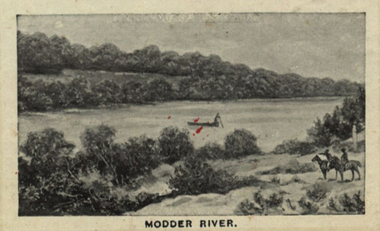
Photograph (black & White), Modder River - South Africa
When war broke out in 1899, and early target for the Boers was the diamond-mining centre of Kimberley. This was located near the point where the Transvaal, Orange Free State and Cape Colony met. General Sir Redvers Buller detached the 1st Division under Lieutenant General Lord Methuen to relieve the Siege of Kimberley. This decision was made partly for reasons of prestige. To capture Kimberley (which contained the famous imperialist and former Prime Minister of Cape Colony, Cecil Rhodes) would be a major propaganda victory for the British. Methuen's force advanced north and won two engagements against the Boers of the Orange Free State. Reinforcements from Transvaal under General Koos de la Rey arrived and he convinced the Boers to follow his plans for attacking the British. Instead of relying on the hills for protection and missing their targets, de la Rey proposed they make use of the flat veld and introduced them to the Mauser rifle with its flat trajectory. Trenches were built in the banks of the Modder River from which they could sweep the veld for a great distance. The trenches were built on the south side of the river and on the smaller Riet River where they meet at Modder River Station. Methuen's force began advancing towards the Modder planning to cross the river. The Boers opened fire and the British troops were unable to find cover on the veld. They had to lay flat so as not to be seen or hit. The British guns pounded the buildings near Modder River Station and the north bank of the river, missing the trenches on the south bank. The battle became a stalemate. The British found an opening on the Boer's right flank at Rosmead ford downstream and drove the Boers out of Rosmead. De la Rey drove them back into a small insecure bridgehead. The Boers feared they were vulnerable and withdrew during the night. Methuen reported that the battle had been "one of the hardest and most trying fights in the annals of the British army". Individual image from photographed poster of tobacco and cigarette cards.boers, diamind-mining, kimberley, transvaal, orange free state, cape colony, sir rdvers buller, lieutenant general lord methuen, siege of kimberley, cecil rhodes, general koos dde la rey, mauser rifle, veld, modder river, modder river station, trenches, riet river, rosmead -
 Bendigo Historical Society Inc.
Photograph - Historical Society Field Trip to the Springs at Sedgwick, Abt 2009
The Phil Wilkin Collection contains a series of 11 Items. The related items can be found by clicking on the reference link below. The following history of the Young family and their descendants who lived at the Springs is provided by Phil Wilkin. His Great Grandparents were Frances Young and August Wirth. Phil has also provided notes on the Wilkin Family and some history of the gold mining in Sedgwick. Frances Young's parents Joseph and Margaret Young owned the property called "The Old Place, Preston Vale or Wellington Flat" at Sedgwick near the Springs. Joseph Young owned and Managed the Standard Brewery which was located at Campbells Creek during the late 1800’s early 1900’s. Joseph and Margaret are buried in the Harcourt cemetery. In 1880 August Wirth lived at Mosquito Creek (Lake Eppalock, Victoria) when he married Frances Young. In 1902 they moved to part of Joseph Young's property. They milked cows and sold cattle for a living. One of their children Charles Wirth (Phil Wilkin's Grandfather) bought the land in 1935 after his parents had died. Charles Wirth was a councillor and also was president of the Shire of Strathfieldsaye. The "Old Place" was part of the property owned by members of the family. The old house at the Springs was burnt out by bushfire in January 1944 and much of the stonework was later vandalized by campers. The original Coliban Water Works were designed in 1863 by the Irish engineer Joseph Brady. The system included 70 kilometres of open water channels, aqueducts, syphons and tunnels to carry water (by gravity) from the Coliban River at Malmsbury, north to Castlemaine and Bendigo. Sedgwick is a locality in Central Victoria, Australia. It is located in the City of Greater Bendigo. Facilities include a public hall that opened in 1958 and CFA Rural fire station. It was named Upper Emu Creek until 1901 when it was renamed as Sedgwick after British geologist Adam Sedgwick.Twenty nine photos taken on a field trip by the Bendigo Historical Society to "The Springs" on the main Coliban water channel from Malmsbury to the Sandhurst Reservoir in Bendigo. The water race descends through a concrete chute, and continues sharply around the contour of the hills. Once it descended into a syphon across the gully. The are 182 photos in this series and can be found at 8683.1 to 8683.11. The series also includes photos of the surrounding farming land and the remains of an old house. There are also some notes on the pioneers of the district.history, bendigo, coliban water, joseph brady, irrigation, the springs, sedgwick -
 Bendigo Historical Society Inc.
Photograph - Historical Society Field Trip to the Springs at Sedgwick, Abt 2009
The Phil Wilkin Collection contains a series of 11 Items. The related items can be found by clicking on the reference link below. The following history of the Young family and their descendants who lived at the Springs is provided by Phil Wilkin. His Great Grandparents were Frances Young and August Wirth. Phil has also provided notes on the Wilkin Family and some history of the gold mining in Sedgwick. Frances Young's parents Joseph and Margaret Young owned the property called "The Old Place, Preston Vale or Wellington Flat" at Sedgwick near the Springs. Joseph Young owned and Managed the Standard Brewery which was located at Campbells Creek during the late 1800’s early 1900’s. Joseph and Margaret are buried in the Harcourt cemetery. In 1880 August Wirth lived at Mosquito Creek (Lake Eppalock, Victoria) when he married Frances Young. In 1902 they moved to part of Joseph Young's property. They milked cows and sold cattle for a living. One of their children Charles Wirth (Phil Wilkin's Grandfather) bought the land in 1935 after his parents had died. Charles Wirth was a councillor and also was president of the Shire of Strathfieldsaye. The "Old Place" was part of the property owned by members of the family. The old house at the Springs was burnt out by bushfire in January 1944 and much of the stonework was later vandalized by campers. The original Coliban Water Works were designed in 1863 by the Irish engineer Joseph Brady. The system included 70 kilometres of open water channels, aqueducts, syphons and tunnels to carry water (by gravity) from the Coliban River at Malmsbury, north to Castlemaine and Bendigo. Sedgwick is a locality in Central Victoria, Australia. It is located in the City of Greater Bendigo. Facilities include a public hall that opened in 1958 and CFA Rural fire station. It was named Upper Emu Creek until 1901 when it was renamed as Sedgwick after British geologist Adam Sedgwick.Twenty five photos taken on a field trip by the Bendigo Historical Society to "The Springs" on the main Coliban water channel from Malmsbury to the Sandhurst Reservoir in Bendigo. The water race descends through a concrete chute, and continues sharply around the contour of the hills. Once it descended into a syphon across the gully. The are 182 photos in this series and can be found at 8683.1 to 8683.11. The series also includes photos of the surrounding farming land and the remains of an old house. There are also some notes on the pioneers of the district.history, bendigo, coliban water, joseph brady, irrigation, the springs, sedgwick -
 Bendigo Historical Society Inc.
Photograph - Historical Society Field Trip to the Springs at Sedgwick, Abt 2009
The Phil Wilkin Collection contains a series of 11 Items. The related items can be found by clicking on the reference link below. The following history of the Young family and their descendants who lived at the Springs is provided by Phil Wilkin. His Great Grandparents were Frances Young and August Wirth. Phil has also provided notes on the Wilkin Family and some history of the gold mining in Sedgwick. Frances Young's parents Joseph and Margaret Young owned the property called "The Old Place, Preston Vale or Wellington Flat" at Sedgwick near the Springs. Joseph Young owned and Managed the Standard Brewery which was located at Campbells Creek during the late 1800’s early 1900’s. Joseph and Margaret are buried in the Harcourt cemetery. In 1880 August Wirth lived at Mosquito Creek (Lake Eppalock, Victoria) when he married Frances Young. In 1902 they moved to part of Joseph Young's property. They milked cows and sold cattle for a living. One of their children Charles Wirth (Phil Wilkin's Grandfather) bought the land in 1935 after his parents had died. Charles Wirth was a councillor and also was president of the Shire of Strathfieldsaye. The "Old Place" was part of the property owned by members of the family. The old house at the Springs was burnt out by bushfire in January 1944 and much of the stonework was later vandalized by campers. The original Coliban Water Works were designed in 1863 by the Irish engineer Joseph Brady. The system included 70 kilometres of open water channels, aqueducts, syphons and tunnels to carry water (by gravity) from the Coliban River at Malmsbury, north to Castlemaine and Bendigo. Sedgwick is a locality in Central Victoria, Australia. It is located in the City of Greater Bendigo. Facilities include a public hall that opened in 1958 and CFA Rural fire station. It was named Upper Emu Creek until 1901 when it was renamed as Sedgwick after British geologist Adam Sedgwick.Twenty six photos taken on a field trip by the Bendigo Historical Society to "The Springs" on the main Coliban water channel from Malmsbury to the Sandhurst Reservoir in Bendigo. The water race descends through a concrete chute, and continues sharply around the contour of the hills. Once it descended into a syphon across the gully. The are 182 photos in this series and can be found at 8683.1 to 8683.11. The series also includes photos of the surrounding farming land and the remains of an old house. There are also some notes on the pioneers of the district.history, bendigo, coliban water, joseph brady, irrigation, the springs, sedgwick -
 Bendigo Historical Society Inc.
Photograph - Historical Society Field Trip to the Springs at Sedgwick, Abt 2009
The Phil Wilkin Collection contains a series of 11 Items. The related items can be found by clicking on the reference link below. The following history of the Young family and their descendants who lived at the Springs is provided by Phil Wilkin. His Great Grandparents were Frances Young and August Wirth. Phil has also provided notes on the Wilkin Family and some history of the gold mining in Sedgwick. Frances Young's parents Joseph and Margaret Young owned the property called "The Old Place, Preston Vale or Wellington Flat" at Sedgwick near the Springs. Joseph Young owned and Managed the Standard Brewery which was located at Campbells Creek during the late 1800’s early 1900’s. Joseph and Margaret are buried in the Harcourt cemetery. In 1880 August Wirth lived at Mosquito Creek (Lake Eppalock, Victoria) when he married Frances Young. In 1902 they moved to part of Joseph Young's property. They milked cows and sold cattle for a living. One of their children Charles Wirth (Phil Wilkin's Grandfather) bought the land in 1935 after his parents had died. Charles Wirth was a councillor and also was president of the Shire of Strathfieldsaye. The "Old Place" was part of the property owned by members of the family. The old house at the Springs was burnt out by bushfire in January 1944 and much of the stonework was later vandalized by campers. The original Coliban Water Works were designed in 1863 by the Irish engineer Joseph Brady. The system included 70 kilometres of open water channels, aqueducts, syphons and tunnels to carry water (by gravity) from the Coliban River at Malmsbury, north to Castlemaine and Bendigo. Sedgwick is a locality in Central Victoria, Australia. It is located in the City of Greater Bendigo. Facilities include a public hall that opened in 1958 and CFA Rural fire station. It was named Upper Emu Creek until 1901 when it was renamed as Sedgwick after British geologist Adam Sedgwick.Twenty five photos taken on a field trip by the Bendigo Historical Society to "The Springs" on the main Coliban water channel from Malmsbury to the Sandhurst Reservoir in Bendigo. The water race descends through a concrete chute, and continues sharply around the contour of the hills. Once it descended into a syphon across the gully. The are 182 photos in this series and can be found at 8683.1 to 8683.11. The series also includes photos of the surrounding farming land and the remains of an old house. There are also some notes on the pioneers of the district.history, bendigo, coliban water, joseph brady, irrigation, the springs, sedgwick -
 Bendigo Historical Society Inc.
Photograph - The Young and Wirth Families at Preston Vale, near the Springs Sedgwick, 1880s-1900s
The Phil Wilkin Collection contains a series of 11 Items. The related items can be found by clicking on the reference link below. The following history of the Young family and their descendants who lived at the Springs is provided by Phil Wilkin. His Great Grandparents were Frances Young and August Wirth. Phil has also provided notes on the Wilkin Family and some history of the gold mining in Sedgwick. Frances Young's parents Joseph and Margaret Young owned the property called "The Old Place, Preston Vale or Wellington Flat" at Sedgwick near the Springs. Joseph Young owned and Managed the Standard Brewery which was located at Campbells Creek during the late 1800’s early 1900’s. Joseph and Margaret are buried in the Harcourt cemetery. In 1880 August Wirth lived at Mosquito Creek (Lake Eppalock, Victoria) when he married Frances Young. In 1902 they moved to part of Joseph Young's property. They milked cows and sold cattle for a living. One of their children Charles Wirth (Phil Wilkin's Grandfather) bought the land in 1935 after his parents had died. Charles Wirth was a councillor and also was president of the Shire of Strathfieldsaye. The "Old Place" was part of the property owned by members of the family. The old house at the Springs was burnt out by bushfire in January 1944 and much of the stonework was later vandalized by campers. The original Coliban Water Works were designed in 1863 by the Irish engineer Joseph Brady. The system included 70 kilometres of open water channels, aqueducts, syphons and tunnels to carry water (by gravity) from the Coliban River at Malmsbury, north to Castlemaine and Bendigo. Sedgwick is a locality in Central Victoria, Australia. It is located in the City of Greater Bendigo. Facilities include a public hall that opened in 1958 and CFA Rural fire station. It was named Upper Emu Creek until 1901 when it was renamed as Sedgwick after British geologist Adam Sedgwick.Thirty Four Photos of Joseph Young's property near "The Springs" on the main Coliban water channel from Malmsbury to the Sandhurst Reservoir in Bendigo. This item contains family history of Joeph's descendant Charles Wirth, who was a councillor for the Shire of Strathfieldsaye. The water race descends through a concrete chute, and continues sharply around the contour of the hills. Once it descended into a syphon across the gully. The are 182 photos in this series and can be found at 8683.1 to 8683.11. The series also includes photos of the surrounding farming land and the remains of an old house. There are also some notes on the pioneers of the district.history, bendigo, coliban water, joseph brady, irrigation, the springs, sedgwick, charles wirth, preston vale, joseph and margaret young, standard brewery campbells creek harcourt, phil wilkin collection -
 Bendigo Historical Society Inc.
Photograph - The Sedgwick Gold Mine, abt 1909
The Phil Wilkin Collection contains a series of 11 Items. The related items can be found by clicking on the reference link below. The following history of the Young family and their descendants who lived at the Springs is provided by Phil Wilkin. His Great Grandparents were Frances Young and August Wirth. Phil has also provided notes on the Wilkin Family and some history of the gold mining in Sedgwick. Frances Young's parents Joseph and Margaret Young owned the property called "The Old Place, Preston Vale or Wellington Flat" at Sedgwick near the Springs. Joseph Young owned and Managed the Standard Brewery which was located at Campbells Creek during the slate 1800’s early 1900’s. Joseph and Margaret are buried in the Harcourt cemetery. In 1880 August Wirth lived at Mosquito Creek (Lake Eppalock, Victoria) when he married Frances Young. In 1902 they moved to part of Joseph Young's property. They milked cows and sold cattle for a living. One of their children Charles Wirth (Phil Wilkin's Grandfather) bought the land in 1935 after his parents had died. Charles Wirth was a councillor and also was president of the Shire of Strathfieldsaye. The "Old Place" was part of the property owned by members of the family. The old house at the Springs was burnt out by bushfire in January 1944 and much of the stonework was later vandalized by campers. The original Coliban Water Works were designed in 1863 by the Irish engineer Joseph Brady. The system included 70 kilometres of open water channels, aqueducts, syphons and tunnels to carry water (by gravity) from the Coliban River at Malmsbury, north to Castlemaine and Bendigo. Sedgwick is a locality in Central Victoria, Australia. It is located in the City of Greater Bendigo. Facilities include a public hall that opened in 1958 and CFA Rural fire station. It was named Upper Emu Creek until 1901 when it was renamed as Sedgwick after British geologist Adam Sedgwick.Four photos of the miners and information on the Sedgwick Gold Mine. There are 182 photos in this series and can be found at 8683.1 to 8683.11. The series also includes photos of the surrounding farming land and the remains of an old house. There are also some notes on the pioneers of the district.history, bendigo, coliban water, joseph brady, irrigation, the springs, sedgwick, phil wilkin collection, sedgwick gold mine -
 Bendigo Historical Society Inc.
Photograph - Joseph and Margaret Young from Preston Vale (near The Springs) Sedgwick, 1800s-1900s
The Phil Wilkin Collection contains a series of 11 Items. The related items can be found by clicking on the reference link below. The following history of the Young family and their descendants who lived at the Springs is provided by Phil Wilkin. His Great Grandparents were Frances Young and August Wirth. Phil has also provided notes on the Wilkin Family and some history of the gold mining in Sedgwick. Frances Young's parents Joseph and Margaret Young owned the property called "The Old Place, Preston Vale or Wellington Flat" at Sedgwick near the Springs. Joseph Young owned and Managed the Standard Brewery which was located at Campbells Creek during the late 1800’s early 1900’s. Joseph and Margaret are buried in the Harcourt cemetery. In 1880 August Wirth lived at Mosquito Creek (Lake Eppalock, Victoria) when he married Frances Young. In 1902 they moved to part of Joseph Young's property. They milked cows and sold cattle for a living. One of their children Charles Wirth (Phil Wilkin's Grandfather) bought the land in 1935 after his parents had died. Charles Wirth was a councillor and also was president of the Shire of Strathfieldsaye. The "Old Place" was part of the property owned by members of the family. The old house at the Springs was burnt out by bushfire in January 1944 and much of the stonework was later vandalized by campers. The original Coliban Water Works were designed in 1863 by the Irish engineer Joseph Brady. The system included 70 kilometres of open water channels, aqueducts, syphons and tunnels to carry water (by gravity) from the Coliban River at Malmsbury, north to Castlemaine and Bendigo. Sedgwick is a locality in Central Victoria, Australia. It is located in the City of Greater Bendigo. Facilities include a public hall that opened in 1958 and CFA Rural fire station. It was named Upper Emu Creek until 1901 when it was renamed as Sedgwick after British geologist Adam Sedgwick.12 photos and historical document of Joseph and Margaret Young. There are 182 photos in this series and can be found at 8683.1 to 8683.11. The series also includes photos of the surrounding farming land and the remains of an old house. There are also some notes on the pioneers of the district.history, bendigo, coliban water, joseph brady, irrigation, the springs, sedgwick, phil wilkin collection, standard brewery campbells creek, joeseph and margaret young -
 Bendigo Historical Society Inc.
Photograph - The Wilkin Family of Sedgwick, 1800s-1900s
The Phil Wilkin Collection contains a series of 11 Items. The related items can be found by clicking on the reference link below. The following history of the Young family and their descendants who lived at the Springs is provided by Phil Wilkin. His Great Grandparents were Frances Young and August Wirth. Phil has also provided notes on the Wilkin Family and some history of the gold mining in Sedgwick. Frances Young's parents Joseph and Margaret Young owned the property called "The Old Place, Preston Vale or Wellington Flat" at Sedgwick near the Springs. Joseph Young owned and Managed the Standard Brewery which was located at Campbells Creek during the late 1800’s early 1900’s. Joseph and Margaret are buried in the Harcourt cemetery. In 1880 August Wirth lived at Mosquito Creek (Lake Eppalock, Victoria) when he married Frances Young. In 1902 they moved to part of Joseph Young's property. They milked cows and sold cattle for a living. One of their children Charles Wirth (Phil Wilkin's Grandfather) bought the land in 1935 after his parents had died. Charles Wirth was a councillor and also was president of the Shire of Strathfieldsaye. The "Old Place" was part of the property owned by members of the family. The old house at the Springs was burnt out by bushfire in January 1944 and much of the stonework was later vandalized by campers. The original Coliban Water Works were designed in 1863 by the Irish engineer Joseph Brady. The system included 70 kilometres of open water channels, aqueducts, syphons and tunnels to carry water (by gravity) from the Coliban River at Malmsbury, north to Castlemaine and Bendigo. Sedgwick is a locality in Central Victoria, Australia. It is located in the City of Greater Bendigo. Facilities include a public hall that opened in 1958 and CFA Rural fire station. It was named Upper Emu Creek until 1901 when it was renamed as Sedgwick after British geologist Adam Sedgwick.17 photos and historical document of the Wilkin Family associated with the Springs near Sedgwick. There are 182 photos in this series and can be found at 8683.1 to 8683.11. The series also includes photos of the surrounding farming land and the remains of an old house. There are also some notes on the pioneers of the district.history, bendigo, coliban water, joseph brady, irrigation, the springs, sedgwick, phil wilkin collection, standard brewery campbells creek, joeseph and margaret young, wilkin family -
 Bendigo Historical Society Inc.
Photograph - The Wilkin Family of Sedgwick - Isaac and Letitia Barcley, 1800s-1900s
The Phil Wilkin Collection contains a series of 11 Items. The related items can be found by clicking on the reference link below. The following history of the Young family and their descendants who lived at the Springs is provided by Phil Wilkin. His Great Grandparents were Frances Young and August Wirth. Phil has also provided notes on the Wilkin Family and some history of the gold mining in Sedgwick. Frances Young's parents Joseph and Margaret Young owned the property called "The Old Place, Preston Vale or Wellington Flat" at Sedgwick near the Springs. Joseph Young owned and Managed the Standard Brewery which was located at Campbells Creek during the late 1800’s early 1900’s. Joseph and Margaret are buried in the Harcourt cemetery. In 1880 August Wirth lived at Mosquito Creek (Lake Eppalock, Victoria) when he married Frances Young. In 1902 they moved to part of Joseph Young's property. They milked cows and sold cattle for a living. One of their children Charles Wirth (Phil Wilkin's Grandfather) bought the land in 1935 after his parents had died. Charles Wirth was a councillor and also was president of the Shire of Strathfieldsaye. The "Old Place" was part of the property owned by members of the family. The old house at the Springs was burnt out by bushfire in January 1944 and much of the stonework was later vandalized by campers. The original Coliban Water Works were designed in 1863 by the Irish engineer Joseph Brady. The system included 70 kilometres of open water channels, aqueducts, syphons and tunnels to carry water (by gravity) from the Coliban River at Malmsbury, north to Castlemaine and Bendigo. Sedgwick is a locality in Central Victoria, Australia. It is located in the City of Greater Bendigo. Facilities include a public hall that opened in 1958 and CFA Rural fire station. It was named Upper Emu Creek until 1901 when it was renamed as Sedgwick after British geologist Adam Sedgwick.Seven historical documents of Isacc and Letitia Barcley who were associated with the Wilkin Family and also with the Springs near Sedgwick. There are 182 photos in this series and can be found at 8683.1 to 8683.11. The series also includes photos of the surrounding farming land and the remains of an old house. There are also some notes on the pioneers of the district.history, bendigo, coliban water, joseph brady, irrigation, the springs, sedgwick, phil wilkin collection, joeseph and margaret young, letitia and isacc barclay -
 Melton City Libraries
Newspaper, Stone Walls protected, 2015
Dry stone construction as a technique is used for much more than paddock walls. Across the volcanic plains of western Victoriaare marvelous sheep dips, stock loading ramps, huts, dams, retaining walls, and the rich and largely undiscovered heritage of indigenous dry stone structures. Dry stone walls indicate many aspects of our rural environment; the geological beginnings of the way the landscape was created, the patterns of early settlement by pastoralists and squatters, the types of stock that grazed the land and the methods of cattle and sheep management, of the efforts to thwart the spread of rabbits .... "For the casual but interested observer dry stone walls are good to look at, to photograph, to get up alongside and see the way they are constructed, to appreciate the varying shapes and sizes of stones and learn of the techniques of keeping often quite rounded stones in place. Apart from walls and other dry stone structures on grazing land we can also see dry stone techniques used in other places and in other phases of our history. Indigenous Australians have built, and continue to build, structures for shelter or hunting or trapping eels and fish in rivers and estuaries around the country. At spots around our coast line there is evidence of simple stone structures built by early maritime explorers. Prospectors in early mining encampments used dry stone construction to build retaining walls or the low walls of rudimentary shelters. If the future of dry stone walls in the Australian landscape is to be assured. wall owners and local governments have to accept and embrace their custodial role in assuring the preservation and celebration of walls. This is not an easy task, but, along with putting the necessary statutory mechanisms to ensure their retention, it is a task that must be pursued. The Dry Stone Walls Association of Australia has as its primary goal the increase in awareness of wall owners and local governments of the importance of dry stone walls. It also seeks to increase the level of training of skilled and semi skilled wallers, and the gaining of rudimentary skills by farmers so that they can maintain their own walls". Melton Star Weekly article about the Stone Wallslandscapes of significance -
 Wodonga & District Historical Society Inc
Photograph - Mac's Hotel, Wodonga, c1870s
“Mac's Hotel" in Wodonga West, one of Wodonga's earliest hotels, was owned by William Christie McFarlane who arrived in Melbourne in December 1854 from Stirling, Scotland. He spent his first three years mining for gold at Beechworth. For the next three years he was the manager of the King’s Hotel at Wooragee, which was owned by his father-in-law, Charles David King. In 1860 he bought 180 acres of land at Wodonga, eventually extending his holdings to 1,000 acres on which he farmed. He called his property “Abbey Craig” after his home in Scotland. In time he owned several properties in Wodonga, a small vineyard and 'Mac's Hotel'. Mac’s Hotel was a popular meeting place for teamsters and other travellers on the Sydney Road. It opened in the early 1860s and the license was at times in the name of W. C. McFarlane and at other times held by his wife, Mary McFarlane. William had several positions during his life in Wodonga including serving as Postmaster and conducting a Commission and Insurance Agency business. He was appointed Secretary to the first Wodonga Building Society. W. C. McFarlane also filled the position of Sheriff’s Officer, Registrar of Births and Deaths and Marriages, and Justice of the Peace. W. C. McFarlane served as a member of the Wodonga Shire Council for several years including three terms as Shire President: 1889-90, 1890-1891 and 1894-95. He passed away in Wodonga in December 1906. After his death, the license of Mac’s Hotel continued to be held by Mary McFarlane until her death in November 1910. The license was not renewed and the hotel was taken over as a residence by their son, Walter McFarlane. Unfortunately, on 25 January 1913, Walter was assisting neighbours fighting grass fires about 3 miles away when his own home was completely destroyed by fire, bringing to an end the long history of the popular hostelry, Mac’s Hotel.This image is significant because it documents an early business in Wodonga conducted by a prominent Wodonga resident.Black and white image of people standing, on horseback and in coach outside Mac' Hotel, West Wodongamac's hotel, hotels wodonga -
 Federation University Historical Collection
Map - Plan, Ballarat Deep Leads and Mines, 1992
This is Bulletin No. 62: Deep Lead Gold Deposits in Victoria. Map No.6 Ballarat Sheet 1 of 2 The map shows geology, topography and information on mines in the following areas: one large map of the Ballarat area with five enlargements for: Sago Hill District; Scarsdale District; Pitfield Plains District; Berringa Gold Field and Rokewood District. Ballarat Mines and Deep Leads Report No.94 (Finlay and Douglas,1992) provides a summary of the Geological Survey of Victoria mines database, references and geology for most of the mines on this map. Geology Compilation: simplified from earlier Departmental mapping with minor field checking by E.N.M. Plier-Malone. Very large rectangular sheet of paper with seven coloured maps of various sizes and a small green rectangle on the bottom rhs with a map of Victoria superimposed over a poppet head. this rectangle includes information of the other maps shown. The background for these maps is white. Also includes tables of names of mine companies, name of shafts and gold production.gold mines of australia, gold mines of victoria, gold mines- ballarat and district, gold mines pitfield plains district, gold mines scarsdale district, gold mines berringa gold field, gold mines rokewood district, gold mines sago hill district, map - gold mines, map - gold mines in victoria, ballarat, pitfield, scarsdale, berringa, rokewood, sago hill, deep lead gold deposits in victoria, geological survey - gold deposits in victoria, mining, gold deposits in victoria, gold mines in victoria, rokewook, pitfield plains -
 Federation University Historical Collection
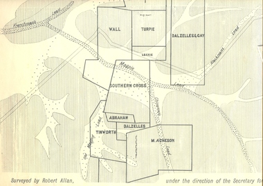
Plan, Underground Survey of Mines, Ballarat East, 1885, 09/1889
Surveyed by Robert Allan under the direction of the Secretary of Mines.Rectangular plan showing placement of mines in 1889. Mines include Hick's and Gilpin's lease, Comstock, Melbourne Company, Victoria United, Speedwell Company, New Normanby, Pasha Surprise, Central Sulieman, West Llanberris, Britannia United, Victoria Unites, Clinton's, Orient Company, North Sulieman, Sulieman Extended, Pasha Surprise, Golden Fountain, Prince regent, Clark and Company, Tinworth, North Woah Hawp, Detering, R.A. Thompson, Dazelles and buchanan, Barnett, Braybrook, Ladt Cornwall, Hanthorne, Dalzelles and gay, Southern Cross, M. Acheson, Cricket Reserveballarat east, mines, mining, underground survey, robert allan, chinese, ah chong, ah young, bakery hill, black hill, black hill lead, bakery hill lead, cricket, pennyweight hill, gravel pitts lead, golden point lead, navy jack's lead, mopoke lead, eureka lead, association lead, warrenheip lead, cgt, plans -
Bendigo Historical Society Inc.
Document - LAZARUS MINE - NOTES ON THE LAZARUS MINE
Five pages of notes on the Lazarus Mine including Lazarus New Chum and Lazarus No 1. Notes include locality, depth of shafts, size of lease and plant. Includes the history, prominence, best gold, Total Gold Yield and Dividends.mining, parish map, lazarus mine, lazarus mine, lazarus new chum, lazarus no 1, george lansell, b. c. v. 8 studios, sheepshead, central red white & blue, mr b lazarus, mr george gibbs, black lead, lansell's fortuna, mr ballerstedt, mr barnet lazarus, white lead, mines department special edition 'australian mining standard' 1/6/1899, mines department booklet 'bendigo goldfield' 1936, mines dept. annual and quarterly reports, annals of bendigo mining sections 1868 - 1910, a richardson, the bendigo goldfield registry j n macartney 1/3/1871. -
Bendigo Historical Society Inc.
Map - BELLE VUE NO 2 - PLAN OF LEASES
Plan of Mining Leases from Rowan Street to Long Gully. Reference J. N. Macartney 2nd Edition Bendigo Goldfields Registry for 1872. Names of Leases are: Moore ?, Ellesmere Co, Bonati & Co, Dennis, Abe Lincoln Co, Lansell & Hunt, Black & White Lead Co, Koch & Hildebrand, Ballerstedt, Lazarus Co No 1, Lazarus Co, Watson, Lazarus Freehold, Lazarus Co No 2, Lazarus Tribute, South Extended Burra, Endeavor Co, Old Chum Co, Burrows and Sterry, New Chum & Victoria Trib, Jackson, North Old Wybrants Chum Co, Myra Co, McLenn, Geary & Co, Western Victoria Hill G. M. Co, Victoria Reef G.M.Co, South Adventure Co, South Try Me Well, W. Rae, Wells Midway, Extended Co, Handy Andy, Moonta Co, Humboldt Co, Adventure Co, Try Me Well, Sterry & Co, Midway, Tudor, Friedman's Reef, Rising Sun, Try Me Luck,Pomponia, Confidence Co, Alfred Co, Advance Co, Prince Alfred Co, Canterbury Co, Platus Co, S. Platus Co, Golden Fleece United, Alfred Co, Iron Duke Co, Victoria Gold Mines Co, Hercules Co and Iron Bark.map, bendigo, mining plan, belle vue no 2, no 2 belle vue new chum & c, j n macartney bendigo goldfields registry 1872, moore ?, ellesmere co, bonati & co, dennis, abe lincoln co, lansell & hunt, black & white lead co, koch & hildebrand, ballerstedt, lazarus co no 1, lazarus co, watson, lazarus freehold, lazarus co no 2, lazarus tribute, south extended burra, endeavor co, old chum co, burrows and sterry, new chum & victoria trib, jackson, north old wybrants chum co, myra co, mclenn, geary & co, western victoria hill g. m. co, victoria reef g.m.co, south adventure co, south try me well, w. rae, wells midway, extended co, handy andy, moonta co, humboldt co, adventure co, try me well, sterry & co, midway, tudor, friedman's reef, rising sun, try me luck, pomponia, confidence co, alfred co, advance co, prince alfred co, canterbury co, platus co, s. platus co, golden fleece united, alfred co, iron duke co, victoria gold mines co, hercules co, iron bark -
 Bendigo Historical Society Inc.
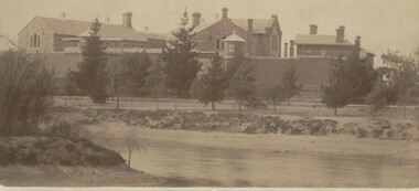
Photograph - BENDIGO GAOL, FROM COMMISSIONER'S GULLY, c.1880
Sepia photograph of the Bendigo Gaol looking across from Barnard Street, Mining dam in foreground. . Conifers along Northern bank of creek with gaol buildings in the background. All buildings are of masonry. Inscriptions: '37' in red ballpoint ink top RH corner. On back of mount: stamped in circle 'Royal Historical Society of Victoria, Bendigo Branch' In blue ballpoint ink above circly '1959' In red ballpoint ink above circle '37'. In blue ballpoint ink in one corner '1880'. Inclusions in storage envelope: Bendigo Gaol, J Lerk, 28/02/2000. The Bendigo Gaol looking across Commissioner's Gully c1880. The grey granite cell blocks contrast with the red brick exterior walls. Photograph courtesy Bendigo Historical Sociery (No. 136, texta on back). Machine printed inclusion worded as above entry. Another inclusion written in pencil states ' Bendigo Gaol about 1880. Granite from Big Hill was used to construct the cell blocks about 1860. Prisioners did not have heating, beds, seats or eating utensils. A public meeting in 1862 called for the debtor's quarters at the gaol to be lit with gas, handsomely furnished throughout and that inmates be provided with a bottle of wine, one bottle of brandy daily and tobacco and pipes availabe at liberty. (from Butcher, 'Annals of Bendigo 1862, Vol. 1, 76B).buildings, government, watch house, sandhurst -
 Bendigo Historical Society Inc.
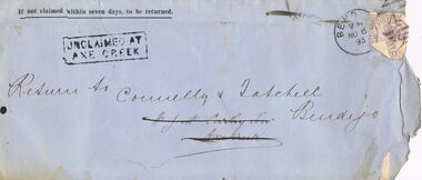
Document - CONNELLY, TATCHELL, DUNLOP COLLECTION: DOCUMENT
Seven unclaimed letters from Connelly & Tatchell, Solicitors, Sandhurst and Connelly, Tatchell & Dunlop, Barristers & Solicitors, Bendigo. Letters in the name of - J. McCarthy Senr., Axe Creek, re fencing land at Axe Creek, dated Sept 26 1891; Mr. Richards, Miner, New Chum, dated 16 Feby 1888, re perusing summons for assault and taking instructions for defence; Mr. James Baker, High Street, Sandhurst, re Attending Mr. Hopkins with respect to contract, dated 3 Nov 1886; Herbert Stokes Fernshaw, re Coffee Palace, St. Kilda, re appearance, letters and advice, dated Sept 11, 14, 16, 28, 30, Oct 5 and 6 1891; Mrs. A. Williams, c/ Mrs. Pinder, Carpenter St. Bendigo re Divorce, dated Dec 1900; Mr. Joseph Metcalf, Mining Manager, Gapsted, re Mortgage, dated 1901, has pink Return to Sender ink stamp; Mr. Gardner, Breen Street, Quarry Hill, re Opie, dated Nov 1901. Four letters have mauve Victoria Two Pence Stamp Duty stamps, one has no stamp, one has a red Victoria One Penny Stamp Duty stamp and one has a lighter red Victoria One Penny Postage stamp.business, legal, connelly & tatchell, connelly & tatchell collection - document, connelly tatchell & dunlop, j mccarthy senr, mr gardner, joseph metcalf, mrs a williams, mrs pinder, herbert stokes fernshaw, james baker, mr hopkins, mr richards -
 Bendigo Historical Society Inc.
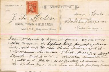
Document - LUDERMAN COLLECTION: SPRING GULLY, MANDURANG DOCUMENTS
Document. Pastel Drawing Book, 'Bulldog' Series No. 589, containing series of invoices and documents relating to the Hargreaves family. Items stuck in book in order includes: invoices from J.R. Hoskin, Bendigo Timber and Iron Yards relating to construction of residence in Spring Gully (1896); Certificate of Registration of Residence Area for Thomas Snowdon, adjoining Hargreaves residence 200 yards from Reservoir; Elector's Right for John Billman Hargreaves of Mandurang, Tanner; handwritten note (Bairnsdale 24.1.34) on John Billman Hargreaves born 1861 on 14 June on Sheepwash Creek in Mandurang riding Shire of Strathfieldsaye near Bendigo possibly registered at Strathfieldsaye, Kangaroo Flat or Bendigo. Father's name John Hargreaves (English) mother's name Hosannah Hargreaves nee Billman'; 2 scrip certificates issued by 'Tanners Gold Mining Compagnie Pipers Hill, Sheepwash' overwritten on top of document ( underneath North Lord Warden Tribute Co., ) scrip certificate issued to John B. Hargreaves on 25 September 1882; invoice Jas. Knowlton, late J. Moody, watchmaker and jeweller, No. 1 Bath Corner, Bendigo 3.8.1895 for Diamond brooch; invoice H. Credginton watchmaker and jeweller and optician for 1 gem ring. Loose document inside contains written advice re taking wool off sheep skins and curing hides.person, individual, hargreaves, hoskins, hargreaves, snowdon, elector's right, tanner's gold mining compagnie, north lord warden tribute co., knowlton, credgington -
 Bendigo Historical Society Inc.
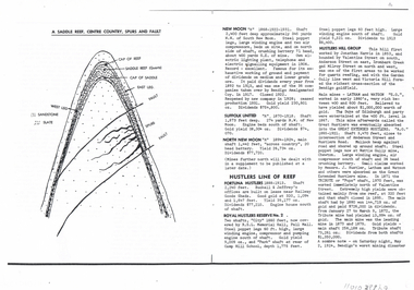
Document - LONG GULLY HISTORY GROUP COLLECTION: HUSTLERS LINE OF REEF
Page mentioning mines on the Hustlers Line of Reef. The are: Fortuna Hustlers, Royal Hustlers Reserve No 2 - City and Park Shafts, Great Hustlers, Latham, Watson, Great Extended Hustlers, Tribute or Pups Shaft, Bendigo's Worst Mining Disaster May 2 1914, Hustlers Reef (Old Hustlers) and Hustlers Reef No 1, Lansell's Comet Lightening Hill Line, The Old Comet (Cooper's Claim), United Hustlers and Redan, K K Shaft, North or New Hustlers (once known as Agnew Hustlers), Derby Line - Johnson's No 3, Paddy's Gully Line, Lansell's 'Sandhurst' (Needle), Needle Loops, Cleopatra Needle top, British American, Collman and Tacchi and South Virginia. Also mentioned is Total Gold Yield, Main Shafts on Field, Price of Gold (Old Currency) and Saddle Reefs and Spurs. Also mentioned are New Moon, Suffolk United, South New Moon and North New Moon. There is a diagram of a Saddle Reef, Centre Country, Spurs and Fault. Depth of shaft, machinery, location, dividends and yields are also mentioned. Price of Gold (Old Currency): 1851-1930, Price varied from Approx. £3/17/6 to £4 per ounce. 1938, from £6/19/10 to £7/8/10 per ounce. 1946/47/48 £10/15/3 per ounce, May 1, 1954 £15/12/6 per ounce.bendigo, history, long gully history group, the long gully history group - hustlers line of reef, fortuna hustlers, buckell & jeffrey's, railway goods sheds, rsl memorial hall, camp hill school, royal hustlers reserve no 2 - city and park shafts, jonathan harris, latham and watson, great hustlers, great extended hustlers, wattle gully mine, messrs j hustler latham and watson, tribute or pups shaft, bendigo's worst mining disaster, hustlers reef (old hustlers) and hustlers reef no 1, lansell's comet, the old comet (cooper's claim, united hustlers and redan, k k shaft, north or new hustlers (once known as agnew hustlers), derby line - johnson's no 3, pa ddy's gully line, lansell's 'sandhurst' (needle), needle loops, cleopatra needle top, british american, collman and tacchi, south virginia, saddle reefs and spurs, new moon, suffolk united, south new moon, north new moon -
Clunes Museum
Photograph - PHOTOGRAPHS OF EVENTS
.1-.23 PHOTOGRAPHS OF THE GOLD FESTIVAL: .1 CDAS FLOAT .2 A PALOMINO WITH RIDER IN FRONT OF THE OLD LIBRARY .3 PEOPLE IN COSTUMES FROM THE GOLD MINING TIME .4 FLOAT FROM THE ANGLING CLUB ON A TRAILER WITH SHRUBS, 2 MEN, "GONE FISHING" ON THE SIDE .5 FLOAT : A TRAILER WITH PEOPLE IN COSTUMES .6 CLUNES PRIMARY SCHOOL PUPILS MARCHING IN COSTUMES .7 M FAWCETT ON A MECHANICAL HORSE .8 BARB ADAM WITH THE HOSPITAL FLOAT\ .9 CLUNES DISTRICT HEALTH SERVICE FLOAT .10 WHEEL BARROW RACE .11 HEALTH SERVICE FLOAT .12 PREPARING HEALTH SERVICE FLOAT .13 CLUNES LIONS CLUB FLOAT .14 A UTE WITH PEOPLE AND FRUIT FLOAT .15 MT CAMERON FIRE TRUCK .16 CLUNES GARDEN CLUB MARCHING WITH FLOWERS AND WHEEL BARROWS .17 MEMBERS OF THE BOWLING CLUB ON A TRUCK .18 CDAS FLOAT .19 M FAWCETT ON A MECHANICAL HORSE .20 PEOPLE IN FRASER STREET AT THE GOLD FESTIVAL .21 MARCHING FIRE BRIGADE .22 PEOPLE LINING FRASER STREET, WAITING FOR THE PARADE .23 CLUNES DISTRICT AGRICULTURAL SOCIETY FLOAT .24 PHOTOGRAPH OF VINTAGE CAR RALLY 2/2001 .25 MINERS WALK TO CLUNES .26 A GROUP OF PEOPLE SOCIALISING .27 PHOTOGRAPH OF PEOPLE AT "BACK TO CLUNES EASTER 1982" .25 WRITTEN ON BACK: JUDITH FAWCETT (BACK), ALISON HULL, JOSIE SEERS, JO BIDWELLgold festival, back to clunes 1982, miners walk, vintage car rally -
 Chiltern Athenaeum Trust
Photograph, JUDGE W. H. GAUNT
This photograph is a copy displayed in the Australian Dictionary of Biography. The original photograph is in the La Trobe Collection in the State Library of Victoria. William Henry Gaunt (1830-1905), judge, was born on 27 July 1830 at Leek, Staffordshire, England, son of John Gaunt, banker, and his wife Mary, née Bakewell. Educated at Leek Grammar School and Whitchurch, Salop, he migrated to Melbourne, and entered the Victorian public service and was rapidly promoted. By March 1854 he was chief clerk at Beechworth, the administrative centre of the Ovens goldfield. In July 1855 the resident warden commended Gaunt as 'a highly valuable public servant' with an intimate knowledge of the district and the 'temper and disposition of the miners'. Appointed sub-warden in the Beechworth district in January 1856 and a Chinese protector in August, he was given control of the extensive Woolshed district. When European miners attacked a party of Chinese at the Buckland River diggings in May 1857 Gaunt was sent to restore order. One of his proclamations, issued in Chinese characters, concluded 'W. H. Gaunt, your protector—tremble and obey!' In June he was appointed a police magistrate and next month was sent to take charge at the Buckland where the Chinese had been expelled from the diggings; the police force assisting him was led by Robert O'Hara Burke. In January 1858 Gaunt was appointed a warden, in November was transferred to Chiltern, north of Beechworth, and in August 1859 was made a commissioner of crown lands. In February 1860 Gaunt was appointed a coroner of Victoria, acting at Indigo, near Chiltern. In April 1865 he was transferred to Beechworth, became visiting justice of the gaol and later moved to Sandhurst. In January 1869 he was appointed returning officer for the mining district of Ballarat and visiting justice of the gaol. He was associated with this area for the rest of his life and won high repute for his integrity. In 1874 he chaired the inaugural meeting of the first Australian competitive swimming club. For years he studied law and was called to the Bar in December 1873. He was one of the many public servants dismissed by Graham Berry on 9 January 1878 (Black Wednesday). After petitioning the Queen in vain over his dismissal he began practice in Ballarat as a barrister. He soon became a leading authority on mining laws; one of the cases in which he was involved was the lengthy inquest on the bodies of the twenty-two miners drowned in the New Australasian mine disaster at Creswick in 1882. He was appointed a temporary judge of the Insolvency Court in 1889 and a County Court judge in 1891. In 1900 he was chairman of the royal commission which considered Metropolitan Board of Works matters, and in 1902 was president of the inquiry into the unification of municipalities in Victoria. In 1860 Gaunt married Elizabeth Mary, the youngest daughter of Frederick Palmer; they had nine children. Of the surviving five sons and two daughters, Ernest Frederick Augustus and Guy Reginald Archer both became admirals and were knighted; Cecil Robert became a lieutenant-colonel, Clive Herbert a government advocate in Rangoon and Mary (Mrs H. L. Miller) one of the first women students to enrol at the University of Melbourne (1881), although she did not complete her degree; she became a successful novelist. Gaunt died on 5 October 1905. An anonymous colleague said: 'I don't think he was ever excelled as a police magistrate, and during the many years he was on the County Court bench he earned the highest regard. His capacities were as unquestioned as his integrity, and more could not be said of any judge'. Select Bibliography Votes and Proceedings (Legislative Assembly, Victoria), 1878, 3, (58) Government Gazette (Victoria), 22 Feb, 15 Aug 1856, 30 June 1857, 5 Jan 1858, 16 Aug 1859, 3 Feb 1860, 7 Mar, 11 Oct 1862, 28 Mar, 4 Apr 1865, 17 May 1867, 9 June 1868, 22, 29 Jan 1869 Ovens and Murray Advertiser, 21 May 1857, 11 Mar 1865 Colonial Secretary's in-letters, goldfields, 25 Mar 1854, 21 July, 18 Nov 1855, 22 Aug 1857 (Public Record Office Victoria) scrapbook and newsclippings (privately held). Related Entries in NCB Sitesview family tree Gaunt, Mary Eliza (daughter)go to ADB entryPhotograph of Judge W. H. Gaunt standing beside chair holding top hat and cane, under glass, in cream frame with cream matte.Printed name underneath: JUDGE W. H. GAUNT -
 Federation University Historical Collection
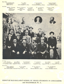
Print - Document, Group of Old Ballarat School of Mines Students in Coolgardie and Kalgoorlie, Western Australia, 1900
In 1900 a group of former Ballarat School of Mines students working in Western Australia commissioned and presented a bust of Professor Alfred Mica Smith to the School. The former students are Claude Maitland (CLark & Co.); A.L. Hay (Queen Margaret Gold Mine); A.S. Lilburne (Freemantle Smelting Works); Latham Watson (Golden Rhine Gold Mine); Arthur Kildahl (Ivanhoe Gold Corporation. Thomas Copeland (Associated Gold Mine); F.A. Moss (Kalgurli Hold Mine, Hainault Gold Mine); W.A. Hearman (New Arrow Propriety); Caradoc James (Golden Link Gold Mine); Alex Fraser (great Boulder Gold Mine); E.O. Watt (Kalgurli Gold Mine); G.M. Roberts (great Boulder Gold Mine); J.J. Dunstan (Chaffers Gold Mine); H.W. Moss, (Kalgoorli Gold Rec. Co); J.A. Hill (Kalgoorli Gold Rec. Co); John Dunstan (Associated Gold Mine); C.M. Harris (Hannans Propriety Development Co. Ltd); W.H. Cobould (Hannans Reward Gold Mine); John W. Sutherland (Golden Horsehoe Estates)The original photo was presented to Professor Alfred Mica Smith by the 'Old Boys' pictured.A printed image of former students of the Ballarat School of Mines, and donors towards commissioning a bust of their former lecturer Professor Alfred Mica Smith. ballarat school of mines, mining, western australia, coolgardie. kalgoorlie, maitland, hay, lilburne, watson, kildahl, copeland, moss, hearman, james, fraser, watt, roberts, dunstan, hill, harris, corbould, sutherland, william corbould, john sutherland, john w. sutherland -
Federation University Historical Collection
Booklet, Open Monument, Ballarat, 2015
Soft covered booklet of 41 pages covering the Open Monument by John Young. 'Open Monument' comprises 2 artworks: A 33 laser-etched granite paneled work, 'transculture', and 'Timeline' which extends of 40 metres and depicts the major contributions of the Chinese community in Ballarat, every decade from 1850 until the present. The timeline then folds out with anticipation to 2070. Each page describes aspects of the monument and the Chinese influence. An timeline of Chinese influence is given at the back of the book.non-fictionchinese, mining, multicultural, immigration, tong way, goon, joss house, embroidery, billy butterfly, chinese market gardens, red lion hotel, ah soon, mayor of main road, chinese herbalist, yee lee, james hong, cheok cheong hong, john ah loo, wathawurrung, robe, lowe kong meng, louis ah mouy, tongway, gallipoli, william lung -
Federation University Historical Collection
Book, G. Quaife, Gold & Colonial Society: 1851-1870, 1975
Gold soft covered book gold, colonial, eureka stockade, diggings, earl grey, convicts, immigration, gold license, gold license fee, gold commission, police, law and order, james scobie, james bentley, catherine bentley, miners statistics, average earnings of miners, mining, quartz crushing, revenue, gold yields, state aid, irish, irish catholics -
 The Beechworth Burke Museum
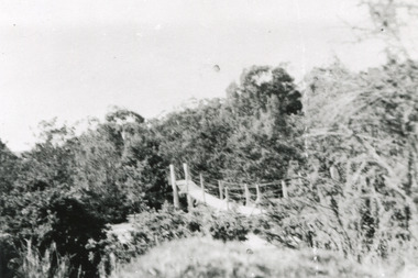
Photograph
This rectangle black and white photograph shows a bush scene with part of a suspension rope and wooden plank bridge visible in the middle of the image. It is likely this suspension bridge was used by the Tannery workers to move between the town and the Ovens Tannery located South-West of Beechworth due to its secluded bush location, the bridge likely spanned the gorge across Spring creek. The tannery itself was located alongside Gimlet Creek, about three kilometres from town, down what is now known as Malakoff and Old Tannery Road but which at the time was remote and accessed through bushland. The Ovens tannery was stablished in 1858 by Matthew Dodd and Hallahan and later Matthew and his brother Thomas Dodd in 1866 who developed it over the years. According to Doyle, 'we have little information about its early operations except the tannery itself comprised four small buildings' by 1870 ‘a small village with gardens of vines and fruit trees surrounded the tannery’ (Woods, 121), and by 1887 the Tannery employed fifteen men. The Ovens tannery was among several new businesses establishing themselves such as a foundry that brought industrial manufacturing alongside the developing township and which strengthened the economic stability of Beechworth after the receding mining surge. According to Woods (p. 121) in the 1860’s the government spent considerable sums to establish several public buildings such as the Benevolent Asylum, the Hospital and Insane Asylum to support those in need of care in the area directly after the Indigo gold rush which had left Beechworth, a fairly remote regional and newly formed township (Gold was first discovered in Beechworth in 1852) with a number of infirm and destitute people in its wake and which due to the support and establishment of these facilities ‘made Beechworth a significant social welfare centre in Victoria’ (Woods, p. 121). The tannery provided employment and connected the regional centre with other parts of Victoria and the wider colonial outposts and would have been a welcome opportunity for those seeking work after gold was no longer a source of income.A good example of the ingenuity of regional settlers to achieve what would have been a difficult and remote construction of a bridge as a means of access. This bridge is evidence of planning and forethought and shows dedication to establishing a life in a remote landscape.Black and white rectangular photograph printed on paperreverse: / 2983 / / BMM2983 /black and white photograph, bush, suspension bridge, rope bridge, tannery, spring creek, ovens tannery, bushland, gimlet creek, matthew dodd, beechworth