Showing 1355 items
matching quick
-
 Warrnambool and District Historical Society Inc.
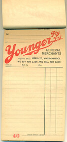
Document - Younger Pty Ltd docket book, 1950s
This booklet of sales dockets came from the Youngers Stores in Warrnambool. John Younger came to Warrnambool from Beechworth in 1888 and established a general store in Liebig Street and quickly built up a thriving business. His store was one of the main reasons why Liebig Street became the main shopping precinct in Warrnambool by the beginning of the 20th century. John Younger was active in community affairs and was a Town Councillor from 1902 to 1918 and Mayor of the Town. He died in the 1930s and his store was continued by family members but taken over by Charles Moore in 1958. It closed in the 1980s. The maker of the docket book, Lamson Paragon Limited, was a British firm with factories and offices in Australia and it initially specialized in making sales docket books using a carbon paper process. The original founder of the firm, William Lamson of Massachusetts, U.S.A., was the first to introduce the system of paying for goods in a store using cash balls on tracks. This pad is of some interest as it shows the system of receipts issued by a Warrnambool firm in the 1950s. It is of particular interest coming from Youngers Stores, a major retailer in Warrnambool for over 90 years. This is a pad of dockets stapled together 30 pages). The pages are buff-coloured with red and black printing on every second page. Every second page has been left blank so that a second copy could be kept of every transaction using carbon paper. The pad originally had dockets for 50 transactions for Youngers Stores in Liebig Street, Warrnambool. The first three pages are badly torn. The back of every docket has an advertisement for Youngers stores.Docket front: ‘Phone 21, Terms, Nett Cash, M……………., Younger Pty Ltd, General Merchants, Registered Office, Liebig St., Warrnambool, We Buy for Cash and Sell for Cash, Sold by, Exd. By, Date, Lamson Paragon Limited.’docket book, younger pty ltd, general merchants, department stores, liebig street, warrnambool -
 City of Kingston
Photograph - Colour, Paul Tresize, 1998
The name Mordialloc was derived from the name Moody Yallock, which comes from the Bunurong language. The Bunurong Peoples are the Traditional Owners of this area. The name means “high water” or “high creek”. In 1839, colonial authorities declared the mouth of the creek, and an additional 830 odd acres as an Aboriginal Reserve, although this proclamation was never gazetted. The reserved land included part of the Carrum Carrum Swamp which was abundant with wild life and natural resources. Regular encroachments, including land sales which began in 1863, were made on the land until 1878 when the Reserve was declared closed, and the land was opened up to land sales. Market gardening and suburban house lots quickly began to develop, and Mordialloc became a renowned picnic and holiday site. Mordialloc Creek is a popular bay side destination for local and visitors, and is a site for boating, kayaking, fishing and swimming, along with many other activities.Colour photograph of Mordialloc Creek, looking out to the bay. Many small fishing and leisure craft are moored on either side of the banks of the creek. To the right hand side can be seen parklands, while the left hand side has a small inlet in which more small crafts are moored.mordialloc, bunurong, traditional owners, suburbs, boats, fishing, waterways -
 City of Kingston
Photograph - Colour, Paul Tresize, 1998
The name Mordialloc was derived from the name Moody Yallock, which comes from the Bunurong language. The Bunurong Peoples are the Traditional Owners of this area. The name means “high water” or “high creek”. In 1839, colonial authorities declared the mouth of the creek, and an additional 830 odd acres as an Aboriginal Reserve, although this proclamation was never gazetted. The reserved land included part of the Carrum Carrum Swamp which was abundant with wild life and natural resources. Regular encroachments, including land sales which began in 1863, were made on the land until 1878 when the Reserve was declared closed, and the land was opened up to land sales. Market gardening and suburban house lots quickly began to develop, and Mordialloc became a renowned picnic and holiday site. Mordialloc Creek is a popular bay side destination for local and visitors, and is a site for boating, kayaking, fishing and swimming, along with many other activities.Colour photograph of Mordialloc Creek with boats moored on both sides of the street and Pompei's boat yard visible on the right hand side of the creek., Main Street and St Brigid's Catholic Church are visible in backgroundmordialloc, bunurong, traditional owners, suburbs, boats, fishing, waterways, hotel, church -
 City of Kingston
Photograph - Colour, 1998
The name Mordialloc was derived from the name Moody Yallock, which comes from the Bunurong language. The Bunurong Peoples are the Traditional Owners of this area. The name means “high water” or “high creek”. In 1839, colonial authorities declared the mouth of the creek, and an additional 830 odd acres as an Aboriginal Reserve, although this proclamation was never gazetted. The reserved land included part of the Carrum Carrum Swamp which was abundant with wild life and natural resources. Regular encroachments, including land sales which began in 1863, were made on the land until 1878 when the Reserve was declared closed, and the land was opened up to land sales. Market gardening and suburban house lots quickly began to develop, and Mordialloc became a renowned picnic and holiday site. Mordialloc Creek is a popular bay side destination for local and visitors, and is a site for boating, kayaking, fishing and swimming, along with many other activities.Colour photograph of Mordialloc Creek, looking inland.Small fishing and leisure boats are moored on either side of creek, with a view of the Mordialloc Bridge Hotel in the background.mordialloc, bunurong, traditional owners, suburbs, boats, fishing, waterways, hotel -
 City of Kingston
Photograph - Colour, Paul Tresize, 1998
The name Mordialloc was derived from the name Moody Yallock, which comes from the Bunurong language. The Bunurong Peoples are the Traditional Owners of this area. The name means “high water” or “high creek”. In 1839, colonial authorities declared the mouth of the creek, and an additional 830 odd acres as an Aboriginal Reserve, although this proclamation was never gazetted. The reserved land included part of the Carrum Carrum Swamp which was abundant with wild life and natural resources. Regular encroachments, including land sales which began in 1863, were made on the land until 1878 when the Reserve was declared closed, and the land was opened up to land sales. Market gardening and suburban house lots quickly began to develop, and Mordialloc became a renowned picnic and holiday site. Mordialloc Creek is a popular bay side destination for local and visitors, and is a site for boating, kayaking, fishing and swimming, along with many other activities.Colour photograph of Mordialloc Creek with boats moored on both sides of the street and Pompei's boat yard visible on the right hand side of the creek., Main Street and St Brigid's Catholic Church are visible in background.mordialloc, bunurong, traditional owners, boats, fishing -
City of Kingston
Photograph - Colour, Paul Tresize, 1998
The name Mordialloc was derived from the name Moody Yallock, which comes from the Bunurong language. The Bunurong Peoples are the Traditional Owners of this area. The name means “high water” or “high creek”. In 1839, colonial authorities declared the mouth of the creek, and an additional 830 odd acres as an Aboriginal Reserve, although this proclamation was never gazetted. The reserved land included part of the Carrum Carrum Swamp which was abundant with wild life and natural resources. Regular encroachments, including land sales which began in 1863, were made on the land until 1878 when the Reserve was declared closed, and the land was opened up to land sales. Market gardening and suburban house lots quickly began to develop, and Mordialloc became a renowned picnic and holiday site. Mordialloc Creek is a popular bay side destination for local and visitors, and is a site for boating, kayaking, fishing and swimming, along with many other activities.Colour photograph of Mordialloc Creek, looking inland. Boats are moored on either side of the creek and the Bridge Hotel is visible in the background.mordialloc, bunurong, traditional owners, suburbs, boats, fishing, waterways, hotel -
 Forests Commission Retired Personnel Association (FCRPA)
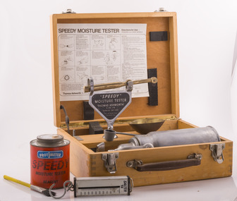
Speedy Moisture Meter, Thomas Ashworth and Co, c 1950
The most common technique to measure fuel moisture content in Victorian forests until recently was the Speedy Moisture Meter. Originally developed in England during the 1920s for measuring moisture in wheat and other grains it was adapted for Australian forest fuels in the 1950s. Fuel was first ground using a Spong mincer, often attached to the bullbar of a vehicle, and a small sample placed into the Speedy together with a measure of calcium carbide and then sealed. A chemical reaction created gas pressure which was read on the external dial. There were important techniques with cleaning, mincing and using the chemicals with the Speedy to give reliable readings, but it was quick, inexpensive, robust, portable and practical in the field. It was used routinely before igniting a fuel reduction burn or measuring fuel moisture differentials on slash burns. In about 1996, Karen Chatto and Kevin Tolhurst from the Department’s Creswick Research Station developed the Wiltronics Fuel Moisture meter which measured electrical resistance.First reliable tool for measuring bushfire fuel moisture content in the fieldSpeedy Moisture Meter in wooden boxmanufactures marks and instructions on usebushfire -
 Vision Australia
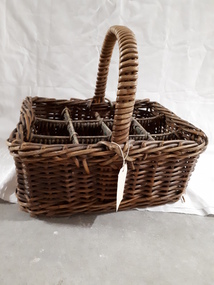
Container - Object, Cane milk bottle basket, 1930-1940
Basket weaving and brush making was a source of income for those who worked in the workshops at RVIB and other institutions in New South Wales and Queensland. A diverse range products could be produced with cane, such as cane chairs, cots, washing baskets and trolleys, and the Institution sought to highlight these in the annual report. Over time the demand for, and supply of, cane changed - particularly during World War 2 when Asian sources were under attack or destroyed. At home, other materials such as plastics as well as the ability to import cheaper pre-produced products further reduced the demand for workshop pieces. A milk bottle basket was designed for milkmen to deliver their wares quickly from door to door, without the bottles impacting upon each other. The milk basket was made in the basket shop of the RVIB for use in the organisation. It was used to carry milk bottles, then containers to the various tea rooms and could have been part of the kitchen equipment for the RVIBCane basket with handle and dividers to carry milk bottlesroyal victorian institute for the blind, equipment, employment -
 Bendigo Military Museum
photograph - Orthorectification Equipment - Army Survey Regiment, Fortuna, Bendigo, c1975
Orthophoto mapping provided the Survey Corps with the capability to produce map products quickly in the event of a crisis. These are four photographs of equipment used by the Army Survey Regiment to produce orthophotomaps. The Wild GZ1 orthophoto projector was introduced in 1973 and was the first equipment used to orthorectify colour and monochrome film aerial photography. Height profiles were originally produced on a PEB8 Stereo profiler and later were software generated. Photos of the PEB8 are available in Victorian Collections item 6222.17P, photos .5P and .6P. In the same era the IBM 1130 computer; OMI/Nistri AP/C-3 analytical plotter with coordinatograph, OP/C orthophoto projector and Zeiss Planimat D2 stereoplotters were introduced. Orthorectification is the process of removing geometric distortions and scale errors/variations from images. Images have tilt and relief distortions that make it difficult to compare accurately a map and an image of the same geographic area. Once an image is orthorectified, features on the image are shown in their planimetric locations. These four photographs of orthorectification equipment were taken at the Army Survey Regiment at Fortuna, Bendigo, c1975. Photo .1P and .3P were printed on photographic paper and scanned at 300 dpi. Photos .2P, .4P and .5P were on 35mm negative film and scanned at 96 dpi. They are part of the Army Survey Regiment’s Collection. .1) - Photo, black & white, c1975, Wild GZ1 orthophoto projector operated by CPL Phil Boyle. .2) - Photo, black & white, c1975, Wild GZ1 orthophoto projector. .3) - Photo, black & white, c1975, Wild GZ1 orthophoto projector. .4) - Photo, black & white, c1978, Zeiss D2 Planimat Stereoplotter. .5) - Photo, black & white, c1978, Zeiss D2 Planimat Stereoplotter..1P to .5P No annotations.royal australian survey corps, rasvy, army survey regiment, army svy regt, fortuna, asr -
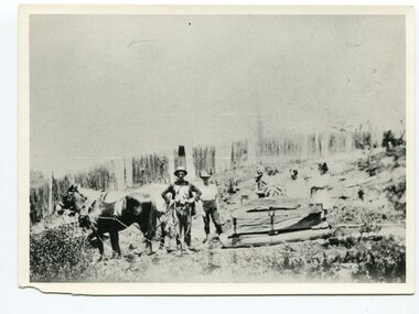 Orbost & District Historical Society
black and white photograph, late 19th century - early 20th century
This photograph shows land clearing at Bendoc. From 1845 the Bendoc area was part of pastoral leases. In the 1850s alluvial gold was discovered in the Bendoc River. This was quickly exhausted, and a number of mines began successful reef operations. At the head of the river, the settlement of Clarkville clustered round several other mines. Many miners, including numbers of Chinese, sluiced the rivers. The population of the area was as high as 500 during this period. The township was surveyed in 1869 and the hotel built in 1870. This building was burnt down in the early 1900s and rebuilt. A school was also begun at this time. In the 1870s there was a decline in gold mining. Some miners selected land, which in many cases is still held by descendants. Dairying was common in the early days, supplying a butter factory at the New South Wales border, and a milk factory at Orbost in more recent times. Wheat was grown for the settlers' own use and ground at Bombala. Now beef cattle grazing is the main occupation. (info. from Victorian Places)This is a pictorial history associated with the early settlement of Bendoc in East Gippsland.A badly distorted black / white photograph of a horse drawn wagon, three men and two women clearing land.on back - "Clearing land at Bendoc"bendoc-land-clearing bendoc-early-settlement -
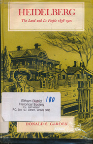 Eltham District Historical Society Inc
Book, Melbourne University Press, Heidelberg: The Land and its People 1838-1900 by Donald S. Garden, 1972
Although Heidelberg was one of the first parts of the Port Phillip District to be settled, and became important and prestigious in the early years of the colony, its history has been largely neglected. The beauty and fertility of the land and its proximity to Melbourne quickly resulted in the establishment in the 1830s and 40s of large estates by wealthy gentlemen. A romantic spot, Heidelberg became popular with picnickers and later attracted an artists' colony. The character of the area then gradually changed as a distinct village community emerged, and market gardens began to flourish. Unlike some of the suburbs closer to Melbourne, Heidelberg eventually wilted under economic pressures from which it did not fully recover until the turn of the century. This book allows us within the larger contect of the colony's fortunes and misfortunes, the struggle of Heidelberg the suburb to be born " - flyleaf. Contents: First land sales and subdivisions, gentlemen of Heidelberg and their estates and activities, infant rural community. golden fifties, decline and backwater, railway and land boom, a maturing community , the depression of the nineties. This book was the first to focus on the area of Heidelberg and its context within the Port Phillip District and remains significant as a key secondary source for describing the history of the area. It is relevant to the contextual history of its neighbour the former Shire of Eltham and Shire of Nillumbik.Hardback. Includes illustrations and index, 219 p.ISBN 0522840191port phillip district, ivanhoe, heidelberg, charles wingrove -
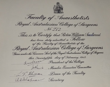 Geoffrey Kaye Museum of Anaesthetic History
Certificate, Fellowship, c. 1965
Robin William Smallwood completed medicine at the University of Melbourne in 1958 and decided on anaesthesia as a career, attaining his FFARACS in 1964. Smallwood was Dean of the Faculty of Anaesthetists at the Royal Australasian College of Surgeons from 1986 - 1987. Smallwood died 6 October 1987 after a brief illness and was awarded the Orton Medal posthumously. The Orton Medal is the highest single achievement the College can bestow. Anaesthesia had its origins in October 1846 in America, by May 1847 news of ether anaesthesia had reached Australian shores and by June 1847 Australian medical practitioners had begun experimenting with and demonstrating ether anaesthesia. Anaesthesia was not really recognised as a distinct branch of medicine in Australia until the first Diploma of Anaesthesia course began in Sydney in 1944. The specialty grew quickly and by 1952 the Faculty of Anaesthesia at the Royal Australasian College of Surgeons had been established. Within 40 years the Faculty had grown to such an extent it became a College in its own right and continues to offer training and professional support to anaesthetists.Printed certificate from the Faculty of Anaesthetists of the Royal Australasian College of Surgeons (RACS) awarded to Robin William Smallwood as a Fellowship. Printed in black ink at the top of the certificate is the RACS coat of arms. The certificate is dated 25 Feburary 1965 and has been signed by President of the College, Member Executive Committee, Dean of the Faculty and the Secretary.smallwood, robin william, orton, robert, faculty of anaesthetists, royal australasian college of surgeons, ffaracs, racs, fanzca -
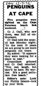 Phillip Island Conservation Society Inc.
Work on paper - Photocopy of newspaper cutting, Wonthaggi Sentinel, or South Gippsland Sentinel Times, "PENGUINS/AT CAPE"
Cr J Gall was a councilor on the Borough of Wonthaggi Council. The Borough included Cape Paterson, where Cr Gall saw 5 little penguins on the beach. He described them as looking for somewhere to nest – that is, to dig burrows in the coast adjoining the Cape Paterson sandy beach. At that stage, the Wonthaggi state coal mine had been closed for 4 years and Wonthaggi had more emphasis on attracting different industries. There was little interest in flora and fauna of the area at that stage. Cr Gall’s unusual sighting of the Little Penguins possibly nesting at Cape Paterson attracted derision from the other councillors, and also a sarcastic Editor's Note from the newspaper's editor - none of which was not surprising for that era. The Borough of Wonthaggi was later amalgamated with the shires of Phillip Island and Bass, plus other areas of a couple of others local shires in 1994 to form Bass Coast Shire Council, which quickly moved to a heavy emphasis on flora, fauna and the tourism industry related to the environment generally.The article clearly demonstrates the disinterested if not dismissive attitude of the Borough of Wonthaggi councillors and the local newspaper editor at the time towards observations of flora and fauna. However, the article is also an interesting record of 5 Little Penguins being sighted at a beach where they were not known to have previously been seen.Photocopy of Single column newspaper article, black print on white paper. Article has curved line border design on top, sides. Cut off in copy at bottom edge. Five paragraphs in main article, and 1 paragraph at bottom marked: Editor's noteSEN 13 - 7 - 72 (South Gippsland Sentinel Times newspaper, 13th July, 1972)little penguins, fairy penguins, eudyptula minor, penguin behaviour, borough of wonthaggi, cr j gall -
 Wodonga & District Historical Society Inc
Domestic object - Vintage Crumb Scraper Set
This item is from a collection donated by descendants of John Francis Turner of Wodonga. Mr. Turner was born on 6 June 1885. He completed all of his schooling at Scotts Boarding School in Albury, New South Wales. On leaving school, he was employed at Dalgety’s, Albury as an auctioneer. In 1924 John was promoted to Manager of the Wodonga Branch of Dalgety’s. On 15/03/1900 he married Beatrice Neal (born 7/12/1887 and died 7/2/1953) from Collingwood, Victoria. They had 4 daughters – Francis (Nancy), Heather, Jessie and Mary. In 1920, the family moved From Albury to Wodonga, purchasing their family home “Locherbie” at 169 High Street, Wodonga. "Locherbie" still stands in Wodonga in 2022. The collection contains items used by the Turner family during their life in Wodonga. A table scraper or sweeper was used in households and fine dining situations to ensure crumbs and small pieces of food could be easily and quickly removed.This item comes from a collection used by a prominent citizen of Wodonga. It is also an excellent example of domestic items used in the early 20th century.A small tray and scraper designed to sweep stray crumbs and bits of food off tabletops. This set has a kookaburra design on each piece,table crumber, dining items, domestic utensils -
 National Wool Museum
Textile - Cloak, Dr Deanne Gilson, Murnong Daisy Cloak (Women Gathering Food) Cloak, 2022
Standing proud, still here, the spirit of ten ancestral matriarchs adorned in contemporary ceremonial cloaks. Representing our women past, present and future, her Spirit, our culture, our Country (spelt with a capital for its importance and this is part of First Peoples protocols on acknowledging Country, our strength, our resilience and healing towards a sustainable future. The murnong was one of the main food sources for First Peoples before colonisation as it grew right across Wadawurrung Dja. The introduction of the sheep and cattle saw the murnong eaten roots and all and it quickly became less plentiful. The tubers were eaten raw or roasted on a fire. Water could be added to make a paste for small children to eat. The woman’s wooden digging stick that was used to gather and harvest plants was often buried with the woman for her afterlife and is considered sacred women’s knowledge. All parts of the plants and trees were and still are honoured as sacred medicine, healing plants and bush food knowledge.Yellow flower and female figure motif on black background on outer cloak, black and white diamond, and circle design in lining. Solid black trimming. Cloak is machine sewn and handstitched with hand stitching on shoulder seam.deanne gilson, wadawurrung dja, first nations art, cloak, murnong -
 J. Ward Museum Complex
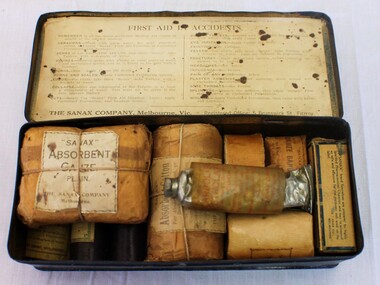
Container - First Aid in Accidents Kit, The Sanax Company – Melbourne Vic
This small, portable 1930’s Sanax First Aid in Accidents Kit has been strongly constructed, the case reinforced with metal to take knocks and bumps as it was transported to the site of an emergency. Having these supplies organised into a kit made them easily accessible and reduces time to take them to the accident site. The text of the printed brand “Sanax - First Aid” embossed on the lid. In Aradale Mental Hospital and J Ward, people are well aware of the institutions remoteness and of the importance of quick treatment when accidents occur. However, prior to the first commercial First Aid Kit being produced in 1888 by Johnson & Johnson, there was limited knowledge about treating injuries and about medical supplies to have ready for emergencies. A quote from Johnson’s & Johnson’s 1888 price list states, “It is a fact ... that many lives are lost and much suffering entailed in such accidents on account of the lack of the simple but necessary articles required to afford prompt assistance to the wounded.” [cited Flagstaff Hill Maritime Village]The kit is significance because it illustrates the first aid paraphernalia used in the care of staff and patients at Aradale Mental Hospital and J Ward. Black tin container. Inside lid shows printed instructions regarding treating various ailments. Contains: Absorbent gauze Canister of castor oil Petroleum jelly First Aid dressing Absorbent dressing Salvolatile ointment Gauze bandage x 3 Ache tablets x 25 3 loose metal safety pins The contents are not dissimilar to items used in first aid kits today. Due to its portable nature, the kit contains many dents and scratches. first aid, medical supplies, sanax -
 Forests Commission Retired Personnel Association (FCRPA)
Drop Chute
From the early 1960s, the Forests Commission had pre-season arrangements in place with local aeroclubs and pilots across regional Victoria. Air observers from FCV districts routinely flew during the summer months in small, fixed-wing aircraft on fire spotting missions and to map fire boundaries. The information was often needed quickly by crews on the ground or in the control centre and these small chutes were used to drop messages and maps from the reconnaissance aircraft on a low pass above a cleared area like a football field. About 3-foot long when fully extended, they had a small pouch secured with a press stud for the map or package. The chutes were made from tough canvas with a small, weighted sandbag at one end and a long yellow streamer tail on the other to help direct its fall and locating it on the ground. Drop chutes were still in common use in the 1990s, but the increased availability of helicopters combined with improved digital data transfer made drop chutes redundant. Simple, but now redundant technologyAerial drop chute"Return to Forests Comm Vic" stenciled on sidebushfire -
 Wodonga & District Historical Society Inc
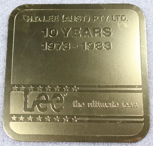
Memorabilia - Souvenir Coasters - H. D. Lee Pty. Ltd, Stephen Daly, 1983
H.D. Lee (Aust) was established in 1973 as a joint venture between Yakka Pty Ltd and Vanity Fair. In 1973 it decided to move to Albury-Wodonga, encouraged by government decentralisation assistance, lower overheads and the central location of the region. H.D. Lee opened a temporary pilot factory with 12 staff in Kiewa Street, Albury, in January 1974 while a new 50,000 sq. ft. factory for 400 staff was built on council land in West Wodonga. This was erected by local builders Zauner Construction, completed in late 1974 and began operations in April 1975. The factory became Australia’s second largest jeans manufacturer and employment in Wodonga at times exceeded 400 staff. In 1991 Yakka, which already owned 50 per cent of the H.D. Lee shares, bought out the rest. It quickly moved to reduce staff and transferred the administration to Broadmeadows. By 1997, the workforce had fallen to 110, and production of Lee and Faberge jeans, jackets and shorts gave way mostly to industrial wear.These coasters represent an industry which was a major employer in Wodonga. The establishment of H. D. Lee (Aust) was a direct result of Australian government's policy of decentralisation in the 1970s. A blue box containing 6 coasters to commemorate 10 years of H.D. Lee operations in Australia. Coasters are gold and include the Lee company logo. The box also includes information regarding the background of the manufacturer, Paul-Stephen Daly.On top half of coaster "H.D. LEE (AUST) PTY LTD /10 YEARS/ 1973-1983" Between lines of stars "Lee the ultimate jean"h.d. lee, wodonga, decentralisation, paul-stephen daly -
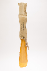
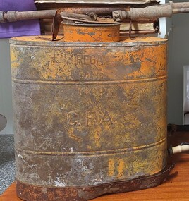 Wodonga & District Historical Society Inc
Equipment - Fire Fighting Knapsack, REGA Products Ltd, c1945
The spraying units were manufactured in Australia by REGA Products. Ltd. in 1926. They established themselves as leaders in the production of agricultural and horticultural spraying machines, including smaller knapsacks. Knapsacks were quickly adapted to a range of applications and were widely used by the C.F.A (Country Fire Authority). They were also widely used for defence during World War II. REGA was later purchased by the Garrard family and still operate as part of Garrads Pty Ltd. This sprayer was one of the units used by the C.F. A. in Wodonga. The Country FIre Authority was established in 1945 following a Royal Commission into the 1939 Black Friday fires which recommended a single firefighting authority for country Victoria, bringing together the Bush Fire Brigades, Country Fire Brigades and Forest Commission. The first fire brigade, the Wodonga Urban Fire Brigade was formed in 1891 and registered in May 1893. Since that time its volunteers have provided ongoing support to the Wodonga and District communities through events such as urban fires, bushfires and other emergency situations. This item is representative of the Wodonga Country Fire Authority and its many volunteers.A knapsack sprayer designed to be used for spraying insects. The unit includes brass fittings, leather straps and a spray arm and nozzle attached. It was also adapted to be widely used by firefighters.On front: REGA / C.F.A. Around lid: REGA SPRAYERSrega sprayers, cfa region 24, cfa volunteers, cfa wodonga, wodonga urban fire brigade, fire fighting equipment -
 Archive of Vietnamese Boat People
Mass grave of VBP in Cherang Ruku, Malaysia
This mass grave is to bury 139 Vietnamese boat people (VBP) in an escape boat of MT065. They arrived at the shore of Cherang Ruku, Kelantan state of Malaysia in the late afternoon of 31 Nov 1978, with the push-back policy, the boat was not allowed to unload a number of more than 300 boat people in the small boat. They had to anchore at a distance of about 200 metre away from the shore. In the early morning of 1-Dec-1978 a storm of the monsoon season quickly swept over the area. The boat was capsized. 139 + 49 boat people were killed. Bodies of 139 VBP were washed ashore into the beach of Cherang Ruku, were collected and buried in this mass grave. The remains of another 49 VBP were collected 4 days later and buried in Balai Bachok, about 30 km away from Cherang Ruku. The 5 grave stones with a name list of 123 VBP were built by the UN HCR with the names they could find. The man who was in charge of burying these VBP was interviewed in 2010, retold the story and confirmed he buried 139 bodies, not 123.Mass grave of VBP in Cherang Ruku, Malaysia -
 Bendigo Historical Society Inc.
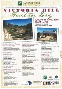
Document - VICTORIA HILL MARONG RD BENDIGO HERITAGE DAY BROCHURE 2010, 2010
Victoria Hill Marong Rd Bendigo (Opposite the Gold Mines Hotel) Heritage Day Brochure 2010. Victoria Hill Guided Tours James Lerk (Bendigo Historical Society) George Ellis (Bendigo Cornish Association) Rod Orr (Bendigo Field Naturalists Club) David Bannear (Heritage Victoria) Presentations: Rod Fraser The Geology of Victoria Hill and Bendigo, Kurt Walder German Heritage Ballerstedts-miners from the Hartz Mountains crushing battery, Rod Orr Mining and the Environment in Bendigo, Michele Matthews (BRAC) Sir John Quick the Forgotten Father of Federation spent his youth in the shadow of Victoria Hill, David Bannear ''Things Forgotten'' - the Archaelogy of Bendigo, Carol Holsworth the Chinese and Victoria Hill area, John Kelly Inquests held at the Gold Mines Hotel, George Ellis The Cornish miners of the Ironbark and Long Gully area, Amanda Jean The Ironbark Heritage Study. Coath Cottage Open Day owner Andrew Ward and Restorer Gary Hill explain the history and restoration of the 1860s miners cottage after Black Saturday fire. Restoration Loans from the City of Greater Bendigo.bendigo, gold mining, heritage day 2010 -
 Bendigo Historical Society Inc.
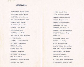
Document - LA TROBE UNIVERSITY BENDIGO COLLECTION: BENDIGO TEACHERS' COLLEGE GRADUATION CEREMONY
A small cream copy of the 1952 Bendigo Teachers' College Graduation Ceremony. On the inside cover is a list of the Graduands - Robert Thomas Armstrong, Francis Arthur Baggage, Aileen Victoria Campbell, Coralie Beatrice Helen Cohn, Mary Therese Collins, Margaret Joan Crawford, Kevin Maurice Cullen, Dulcie Olive Dann, June Rachel Dolling, Lorna McPherson Donaldson, Dorothy Doyle, Kathleen Frances Farrell, Hugh Lionel Fawssett, Joan Mary Flynn, Peter John Gurry, Ailsa Jean Holland, Jeffrey James Layther, Maxwell John Lee, Ronald William Longstaff, Noel David Millar, Ronald Henry Ogier, Pamelia Margaret Pape, Margaret Alice Quick, Neil James Redfern, Elizabeth Ann Roberts, Margaret Elizabeth Roberts, Joan Margaret Rosengren, Neil Ross, Heather Dawn Sheehan, John Marley Sheen, Elizabeth Mary Sleep, William George Shand Smith, Joyce Margaret Spalding, Alan Robert Trethewey, Margaret Tripcony, Francis Elizabeth Verge, Kevin James Reynolds Warren and Elizabeth Marie Williamson. Within the program is a loose sheet of paper with a copy of the graduation procedure.bendigo, education, bendigo teachers' college graduatio, latrobe university bendigo collection, collection, bendigo teachers' college, bendigo, education, teaching, teachers, student, bendigo teachers' college graduation, graduation, bendigo teachers' college students, bendigo teachers' college staff, tertiary education, book, history -
 Bendigo Historical Society Inc.
Newspaper - JENNY FOLEY COLLECTION: SNIPPETS OF BENDIGO
Bendigo Weekly from Friday, June 28, 2002 - Snippets of Bendigo history, the Pall Mall story, part two - by Edith Lunn. Close to the jeweller's shop, we came to Chancery Lane. Many early legal firms had their offices there. Among them were: Quick&Rymer, Luke Murphy&Don and Macoboy&Taylor. A branch of the Bendigo united Friendly Society's Dispensary opened on the corner. Other small business in the walk included a florist, men's hairdresser and a boot and shoes repairer. Moving on there was Betteridge's Agency for the Singer sewing machine company, Wilkinson's photographic studio, Sutton's music shop and Favaloro's cake shop and café the ''Savoy'' was opened in the 1920's. Whitelock and Carter had their men outfitters business in the building, Cocking's was a very popular drapery store. After Cocking's closed down, Stoneman's supermarket opened in the premises. Alongside there was a passageway that led upstairs to the office of Phillip Secher and Son, Accountants and the Bendigo jockey club. Mrs Allan's baby wear business and Lenten's the tobacconist came after and last but not least the Shamrock Hotel enhances Pall Mall. The clip is in a folder.newspaper, bendigo, bendigo weekly -
 Bendigo Military Museum
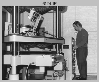
Photograph - Cartographic Production – Army Survey Regiment, Fortuna, Bendigo, c1960 -1975
This is a set of 10 photographs of Cartographic Squadron technicians undertaking map production tasks in at the Army Survey Regiment, Fortuna, Bendigo circa 1968 to 1975. Production was undertaken on the top floor of Fortuna Villa. The Fotosetter type setting machine shown in photos .1P and .2P. replaced the letterpress method of type production in 1956. CPL Arty Lane specialised in the operation of the Fotosetter type setting machine for many years. For more information on the Fotosetter, see page 71 of Valerie Lovejoy’s book 'Mapmakers of Fortuna – A history of the Army Survey Regiment’ ISBN: 0-646-42120-4. The computer based Editwriter Model 7500 typesetting system shown in photos .3P and .4P. was introduced in 1975 as a replacement to the aging Fotosetter. It was operated by a specialised technician, who generated a large variety of map type styles and sizes quickly and reliably, as well as text panels. Output on Copy proof adhesive backed stripping type film replaced messy wax and spray adhesives in 1978. The Editwriter capability supported all RASvy units and its contractor type setting requirements. The Aristo Co-ordinatorgraph shown in photos .5P to .7P was introduced in 1962. It was a large heavy steel framed light table with a scribing head that moved in a XY direction using a vernier calibrated measuring scale to 0.001 of an inch. Whilst hand operated it was much quicker and accurate than manual grid and graticule calculation, plotting and scribing. The history of co-ordinatorgraphs is covered in more detail with additional historic photographs, in pages 50 to 51 and page 88 of Valerie Lovejoy’s book 'Mapmakers of Fortuna – A history of the Army Survey Regiment’ ISBN: 0-646-42120-4. The scribing process as shown in photos .8P to .9P was the cartographic process of drafting features such as drainage, relief, vegetation, roads and culture on specially coated map reproduction material. The cartographic technician scribed out the map feature such as a contour to a specified line width on the map sheet, using a tool affixed with a sapphire tipped cutter. The quality control edit (Proving) stage of map production shown in photo .10P was the first opportunity to independently and systematically inspect a proof of the map.This is a set of 10 photographs of cartographic Squadron technicians undertaking map production tasks at the Army Survey Regiment, Fortuna, Bendigo, c1968 to c1975. The photographs were on 35mm colour slides and scanned at 96 dpi. They are part of the Army Survey Regiment’s Collection. .1) to .2) - Photo, colour, c1968, Fotosetter type setting machine, CPL Arty Lane. .3) to .4) - Photo, colour, c1975, Typesetting machine, ‘Editwriter’ Model 7500. .5) - Photo, colour, c1960s, PTE Desi Asaris and CPL Kalen Sargent operating Aristo Co-ordinatorgraph equipment. .6) - Photo, colour, c1970s, L to R: CPL Desi Asaris, CPL John Bennett, operating Aristo Co-ordinatorgraph equipment. .7) - Photo, colour, c1970s, L to R: CPL John Bennett, CPL Desi Asaris operating Aristo Co-ordinatorgraph equipment. .8) - Photo, colour, c1970s, L to R: CPL Desi Asaris scribing drainage, CPL John Bennett. .9) - Photo, colour, c1970s, CPL Desi Asaris scribing drainage. .10) - Photo, colour, c1970s, L to R: CPL Desi Asaris, CPL John Bennett and their supervisor WO2 Roger Rix inspecting features on an aeronautical chart proof. .1P to .10P There are no annotations stored with the 35mm slides.royal australian survey corps, rasvy, army survey regiment, army svy regt, fortuna, asr, carto -
 Federation University Historical Collection
Photos, 71st Infantry Band Broadmeadows Camp
71st Infantry Band based at the Broadmeadows Camp 1917. Percy Code write a piece of music called the 71st Infantry Quick March. (http://trove.nla.gov.au/work/31795246?selectedversion=NBD11485892) The Ballarat phase of the battalion's history was formed as the Ballarat Volunteer Rifle Regiment on 9 August 1858 as a result of the Crimean War, coupled with the withdrawal of the British Army in 1857. In the years between its formation and the outbreak of War in 1914, the battalion went through a series of name changes as follows: 1854 – Earliest units of the RVR formed ( Melbourne Volunteer Rifle Regt. ) 1858 – Ballarat Volunteer Rifle Regiment (later Rangers) 1884 – 3rd Balarat Ballarat Infantry 1892 – 1st Battalion, 3rd Victorian Regiment 1898 – 3rd battalion, Victoria Infantry Brigade 1901 – 3rd Battalion Infantry Brigade 1908 – 1st Battalion 7th Australian Infantry Regiment 1912 – 70th Battalion (Ballarat Regiment) including Geelong 1912 – 71st Battalion (City of Ballarat Regiment) (From http://www.internationalhistoriansassociation.com/~internat/ihawiki/index.php?title=8th/7th_Battalion,_Royal_Victoria_Regiment).1 Large group photo of members of the band .2 Photograph of part of the band The soldier in the front holding the conductor's batton is Percy Code. The trombone player next to Percy Code is Jack Shackles. 71st Infantry Band (Percy Code Bandmaster) Broadmeadows Camp 191771st infantry band, broadmeadows camp, percy code, code, frank wright, brass band, percy shackles, shackles -
 Vision Australia
Document - Text, Neil Maxwell 11th July 2001 - tributes
Summary update of Centenary AppealHand written testimonies to Neil's work at AFB and VAF. The card reads: Dear Neil, Thank you for showing us the way. We look forward to working with you in all the Kooyong Committee's future endeavors. (Signed by) Margaret Deane, Judith Williams, Bette MacSween, Don Lee, Eve Lustig, Greg ?, Mavis ? The paper reads: Neil Maxwell has always been a very special person over the years he has been at Kooyong. He has been on the board of the Association for the blind from 1984-1993 and became a Director. Neil also became a Tour Guide on the 1st February 1989 and he was tutored by Marjory Lane, and he became very adept in learning new information very quickly. He worked with the Guides until the 7th April 1997. He has also joined the Kooyong Committee and became Chairman in 1998. Neil has given a lot of years to Vision Australia Foundation. He has always been a giver not a taker. Thank you Neil from The Kooyong Committee.Collection of cards paying tribute to Neil Maxwellnon-fictionelizabeth maxwell, neil maxwell -
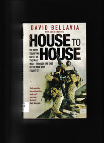 Monbulk RSL Sub Branch
Book, Pocket Books et al, House to house : an epic memoir of war, 2008
Ill, p.320.non-fictioniraq war - personal narratives, iraq war - battle of fallujah -
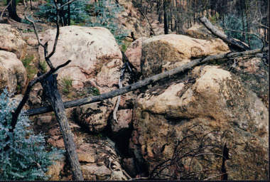 Wooragee Landcare Group
Photograph, circa April 2003
This is a photograph taken in the Chiltern - Mount Pilot National Park near Chiltern in Victoria. On this day, the Wooragee Landcare Group was in the national park looking for signs of the tiger quoll. Tiger quolls can be found in few places with the Chiltern - Mount Pilot National Park being one of them. This photograph is of a tiger quoll nesting site as tiger quolls often nest between large rocks. This image also shows the damage caused by the 2003 bushfires. These bushfires happened at the same time as the 2003 Alpine bushfires. This bushfire started by lightning and quickly became the largest fire in Victoria since the 1939 Black Friday bushfires. The Alpine bushfires destroyed 1.3 million hectares and burnt for 59 days before it could be controlled. The 2003 bushfires severely damaged the environment and concern was raised about the safety of tiger quoll. This photograph displays how the nesting site was damaged by the fire. This meant that the quoll itself could have also been impacted by the fire. Hence why the Wooragee Landcare group went for a search for signs of the quoll.This photograph is significant because it shows a tiger quoll nesting site. Tiger quolls are a highly valuable species because they live in very few places. This, in turn, makes their nesting site valuable. This photograph also signifies the impact of the 2003 bushfires on the Chiltern - Mount Pilot National Park. The image displays burnt trees which makes it clear that the fire was deeply damaging. The fallen log over the nesting site demonstrates how the bushfire must of put the tiger quolls at risk because of how the fire damaged their nesting site. Landscape coloured photograph printed on gloss paperReverse: WAN NA 0ANA0N0 NNN+ 1 1636 / [PRINTED] (No.9) / 923bushfires, mount pilot chiltern national park, mount pilot, chiltern, victoria, wooragee landcare group, wooragee landcare, wooragee, national park, tiger quoll, 2003 bushfires, beechworth, rocks, nesting site, photograph, 2003 alpine bushfires, 1939 black friday, 2003, hectares, fire, damage, burnt, burn -
Federation University Historical Collection
Booklet - Booklet - Syllabus, Government Technical School, Hobart, Syllabus, 1892
The Tasmanian Parliament made provision for 'the teaching of the principles of technical education' in the Education Act (1885). Regulations specifying courses of instruction and establishing a committee of Technical Education followed in 1887. The first government Technical School opened in Hobart in 1888, offering evening classes in technical art and applied mechanics. Two months later a school was established in Launceston. Small classes were also held in regional centres and Schools of Mines were established in Zeehan, Queenstown and Beaconsfield. Curricula quickly expanded to include subjects ranging from mineralogy and metallurgy to commercial economy, beginning the long tradition of directly linking the schools with the interests of business and industry. The Technical Schools largely worked independently, with varying degrees of success, until 1916 when a Commission of Inquiry recommended the integration of technical education into the state education system. The outcome was a new Technical Education Branch, formed to administer Technical Schools and Schools of Mines and to provide a structured technical education system, comprising distinct trade certificates and applied sciences, engineering and arts diploma courses. Pale orange soft covered booklet.hobart, technical school, syllabus, malcolm kennedy, a. mault, r.s. pemberton, a. morton, a.j. taylor, henry lamb, j. mcmeekin, j.h. hunt, j.r. trantham-fryer, f.g. howell, w. middleton, trevor russell, j.f. echlin, w.f. ward, archibald park, a paton miller, committee members of technical education, department of art, department of mathematics, department of engineering, department of commercial economy, department of geology mineralogy mining, department of chemistry, department of pharmacy, department of veterinary science -
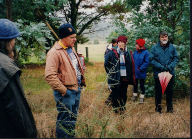 Wooragee Landcare Group
Photograph, 20th June 2004
This photograph was taken on the 20th June 2004 as part of an event called "Successful Tree Planting!", organised by the Wooragee Landcare Group. It was addressed to all local residents and landholders in the area and involved practical demonstration of techniques suitable for successful planting of native trees and shrubs, as well as information about weed control. In the photograph are illustrated from left to right the following people: Chris Robinson; Tony Prowse; unknown child; Lesley Finedon; Ann Henderson, unknown. Revegetation can improve the condition of remnant vegetation in the area and provide habitat for local animals. Correct species selection, including all layers of vegetation, along with proper weather conditions and adequate site preparation, can maximise the successful outcome. Weed-free conditions and protection from rabbits and kangaroos are two more factors contributing to a quick plant growth. Wooragee Landcare, since its establishment in 1998, has organised a series of events and activities in order to promote weed and pest control, provide assistance and knowledge to landholders and ensure sustainability and protection of natural vegetation.The photograph is an example of the type of events and activities organised by Wooragee Landcare to educate and inform local residents and landholders on the most suitable techniques for successful planting of native trees and shrubs. Wooragee Landcare, abiding by its mission statement, promotes best land management strategies and ensures sustainability through collaboration with local community and council agencies.Landscape coloured photograph printed on gloss paper. Reverse: WAN NA 0ANA0N0 BN1+ 1 1636/ [PRINTED] (No.21)/935/successful tree planting, wooragee landcare group, 20th june 2004, successful planting, native trees and shrubs, weed control, revegetation, remnant vegetation, habitat, local animals, species selection, weather conditions, site preparation, weed-free, rabbits, kangaroos, plant growth, 1998, sustainability, natural vegetation