Showing 1222 items
matching relocation
-
 Bendigo Historical Society Inc.
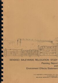
Book - BENDIGO SALEYARDS COLLECTION: BENDIGO SALEYARDS RELOCATION STUDY - PLANNING REPORT AND ENVIRONMENT
Bendigo Saleyards Relocation Study - Planning Report and Environment Effects Statement for the City of Bendigo by A E Huefner & Associates Pty Ltd in association with Meldrum Burrows & Partners. Book has a light brown cover with black plastic binder spine. Green and yellow pages separate some sections. The front cover has a sketch of a stock transport with a pig, sheep and cattle behind gates. Contents include: Introduction, Summary, Recapitulation on the Feasibility Report which includes The Need for Action, the Site and Existing Uses Adjacent to the Site, The Proposal which includes Concept, Project Description, Components, Siting of Facilities, Land Clearing, Earthworks, Darainage, Buildings and Structures, Roads and Pavements, Services, Landscaping, Soil Profile and Construction Programme. Invironmental Effects which include Visual Impact Dust, Odours, Effluent, Effluent Treatment System, Traffic, Artificial Lighting, Noise, Operational Failures and Nature Conservation Effects. Statutory Planning Considerations which includes Zoning Controls and Suggested Procedure for Initiating I.D.O. Amendment. Appendices are: A.- Copy of Tit;e, B - Soil Investigation, C - Acoustic Assessment and D - Suggested Draft Amendment to Shire of Marong I.D.O. Contains a photo of the area - View of the Site, looking South and a number of drawings. Copies of various Council Reports referring to the Saleyards Relocation Project. It has a bright yellow cover and a hard plastic type spine. Mentioned in the reports is the cost to bring the old saleyards up to standard and list of improvements. Reports are as at 16th July, 1984. Mustard coloured book with plastic spine titled Bendigo Saleyards Relocation Study Feasibility Report by Meldrum Burrows & Partners in association with A E Huefner & Associates Pty Ltd and Acil Australia Pty Ltd dated September, 1983. Items mentioned are: Introduction, Summary, Background, Role in Livestock Marketing for the Bendigo Saleyards (Acil Australia Pty. Ltd., Saleyard Relocation: Strategic Considerations, Financial Implications and Conclusion. Appendix 1: Estimation of Livestock Population in Catchment Area. Drawings in Fig 1 Existing Bendigo Saleyards and Surrounding Land Uses, Fig 2 Catchment Area for Bendigo Saleyards 1983, Fig 4.1 Estimated Sheep Populatiuon in Catchment Area 1976 - 77 to 1981 - 82, Fig 4.2 Estimated Cattle Population in Catchment area 1976 -77 to 1981 -82, Fig 3 Possible Saleyard Relocation Areas, Fig 4, Directions from which access to possible Saleyard Locations would be obtained - Estimated percentage of sheep to cattle stock, Fig 5 Possible Saleyard Locations - Northern Area, Fig 6 Possible Locations of Saleyards - Inner West, Fig 7 Possible Locations of Saleyards - Outer West. Considerations were made as to renovate the existing saleyards or to move them elsewhere. Effluent, transport and stock movement, and condition of the yards were a problem.bendigo, council, cattle markets, bendigo saleyards collection - bendigo saleyards relocation study - planning report and environment effects statement, a e huefner & associates pty ltd, meldrum burrows & partners, city of bendigo, state electricity commission, mal styles, bendigo college of advanced education, n j fieldew, pryce goodale & duncan pty ltd, p b swift, shire of marong -
 Melbourne Legacy
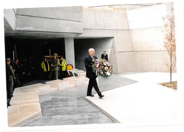
Photograph, Pilgrimage to the Shrine 2003, 09/2003
Wreath laying ceremony for Legacy widows at the Cenotaph at the Shrine of Remembrance. This is an annual event for Legacy widows at the start of Legacy Week, which is the first week in September. The photos show President David Ford carrying a wreath to be laid in the Garden Courtyard. The plants in the Garden Courtyard have been selected because they are native to the Mediterranean countries in which Australians have served. The olive tree planted by Legacy in 1972 was relocated to the new courtyard as part of the Shrine redevelopment. It stands as a centrepiece, representing peace. This is the olive tree of peace that was planted by Legacy in 1973 to mark their golden jubilee. It was relocated to the new courtyard in 2002 when the Shrine was being redeveloped. These photos are from 2003 when David Ford was president (see also 00614).A record of a ceremony at the Shrine 2003.Colour photo x 3 of the president laying a wreath in the Garden Courtyard at the Shrine.Printed on the back No.< > Clarendon Photos 0013 which is the frame numbers and place of processing. Negative numbers 18A, 19A and 22A.widows, widows' sunday, pilgrimage, wreath laying ceremony -
 Eltham District Historical Society Inc
Negative - Photograph, Eltham War Memorial Obelisk 1914-1918, cnr. Main Road and Bridge Street, c.1925
Located on what was referred to as Obelisk Corner, improvements have been been made since the unveiling in August 1919 with the provision of a stone retaining wall topped with a chain link and granite stone boundary, most likely in conjunction with improvements to the intersection into Main Road. Along with the use of the name Obelisk Corner, the Bridge Street bridge was also known as Obelisk Bridge. The Eltham Obelisk was originally located at the corner of Bridge and Main Roads in 1919. In 1943 (WW2) the local community commenced plans to establish the Eltham War Memorial, a living memorial to benefit the children as opposed to a one in stone as per the obelisk. The Eltham War Memorial Trust was established in 1945. In 1947 the Trust intended for the Obelisk to be relocated from Bridge Street and Main Road to the Garden of Remembrance which was planned as part of the Baby Health Centre which was to be the first of three buildings of the Eltham War Memorial to be built in 1951. In 1951 the Eltham RSL was invited to be represented on the Eltham War Memorial Trust. Around this time, with pending roadworks, the obelisk was relocated to the front garden of the Eltham RSL sub branch on Main Road for safe keeping. In 2007, a suggestion was proposed by Harry Gilham (President, EDHS) to John Cohen (ERSL) to claim a special site along with the historic Shillinglaw trees on the now vacant former Eltham Shire Office site adjacent to the Eltham War Memorial precinct for relocation of the obelisk. In 2010 following the financial collapse and sale of the Eltham RSL Sub-Branch property and amalgamation with the Montmorency Eltham RSL sub-branch, the location of the obelisk was again in immediate jepoardy and in conjunction with Nillumbik Shire Council, the obelisk was relocated in front of the Eltham War Memorial buildings in preparation for the Dawn Service on Anzac Day 2012.This photo forms part of a collection of photographs gathered by the Shire of Eltham for their centenary project book,"Pioneers and Painters: 100 years of the Shire of Eltham" by Alan Marshall (1971). The collection of over 500 images is held in partnership between Eltham District Historical Society and Yarra Plenty Regional Library (Eltham Library) and is now formally known as the 'The Shire of Eltham Pioneers Photograph Collection.' It is significant in being the first community sourced collection representing the places and people of the Shire's first one hundred years.Digital image 4 x 5 inch B&W Negsepp, shire of eltham pioneers photograph collection, eltham, main road, eltham war memorial, bridge street, obelisk, obelisk corner -
 Eltham District Historical Society Inc
Photograph, Eltham War Memorial 1914-1918. Cnr. Main Road and Bridge Street, 3 August 1919
Dated 1919, the Eltham Obelisk is decorated with wreaths, most likely for what was originally known as Armistice Day though now known as Remembrance Day, 11 November. The location of the Obelisk at the corner of Bridge Street and Main Road became known as Obelisk Corner and the Bridge Street bridge was also referred to as Obelisk Bridge. The Eltham Obelisk was originally located at the corner of Bridge and Main Roads in 1919. In 1943 (WW2) the local community commenced plans to establish the Eltham War Memorial, a living memorial to benefit the children as opposed to a one in stone as per the obelisk. The Eltham War Memorial Trust was established in 1945. In 1947 the Trust intended for the Obelisk to be relocated from Bridge Street and Main Road to the Garden of Remembrance which was planned as part of the Baby Health Centre which was to be the first of three buildings of the Eltham War Memorial to be built in 1951. In 1951 the Eltham RSL was invited to be represented on the Eltham War Memorial Trust. Around this time, with pending roadworks, the obelisk was relocated to the front garden of the Eltham RSL sub branch on Main Road for safe keeping. In 2007, a suggestion was proposed by Harry Gilham (President, EDHS) to John Cohen (ERSL) to claim a special site along with the historic Shillinglaw trees on the now vacant former Eltham Shire Office site adjacent to the Eltham War Memorial precinct for relocation of the obelisk. In 2010 following the financial collapse and sale of the Eltham RSL Sub-Branch property and amalgamation with the Montmorency Eltham RSL sub-branch, the location of the obelisk was again in immediate jepoardy and in conjunction with Nillumbik Shire Council, the obelisk was relocated in front of the Eltham War Memorial buildings in preparation for the Dawn Service on Anzac Day 2012.This photo forms part of a collection of photographs gathered by the Shire of Eltham for their centenary project book,"Pioneers and Painters: 100 years of the Shire of Eltham" by Alan Marshall (1971). The collection of over 500 images is held in partnership between Eltham District Historical Society and Yarra Plenty Regional Library (Eltham Library) and is now formally known as 'The Shire of Eltham Pioneers Photograph Collection.' It is significant in being the first community sourced collection representing the places and people of the Shire's first one hundred years.Digital image 4 x 5 inch B&W Negsepp, shire of eltham pioneers photograph collection, eltham, main road, bridge street, eltham war memorial, obelisk, obelisk corner, wreath -
 Ballarat Tramway Museum
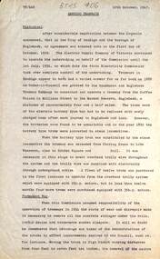
Document - Report, State Electricity Commission of Victoria (SECV), "Bendigo Tramways", 10/10/1947
Gives historical notes about the Bendigo trams, battery trams, steam, and then electric trams. Has a note about the early tracks and upgrading by the SEC, track relocation, overhead rehabilitation and rolling stock. Gives notes about acquisition of the trams ex MMTB, the Birneys and max traction trams.Yields a information about the early history of the trams in Bendigo. Gives information about the track, overhead and tramcars - 1947.Two page, typed notes on foolscap paper, titled "Bendigo Tramways", dated 10-10-1947, with initials "TT/DAS" in the top left hand corner. In top right hand corner in black ink "BTPS 406"trams, tramways, bendigo, sec, mmtb, track, overhead, rolling stock -
 Port Fairy Historical Society Museum and Archives
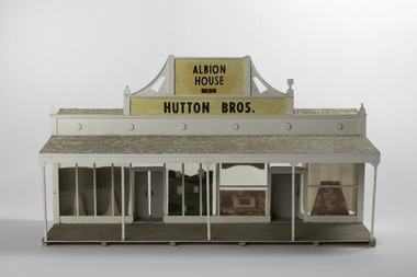
Mixed media - Model, Albion House, early 1970`s
This model was part of a panorama of 11 pieces designed from drawings in an 1892 almanac Printed by Port Fairy Gazette. The panorama was used in the History Society rooms in Bank St Port Fairy on an extended mantel piece, before the Museum and Archives were relocated to Gipps Street Port FairyThis model was made as a part of an eleven piece panorama of the streetscape of Port Fairy in 1892. By a local resident of the town.Small hand made 3D model of a shop front from the 1892 AlmanacAlbion House 1854 Hutton Bros.sackville street, model, mewkill, almanac, albion house, bank street -
 Ringwood and District Historical Society
Newspaper, Scrapbook Clipping, Library Collection, Ringwood, Victoria
Newspaper Clipping from "The Post", 3 May 1993, Page 4, "Manager sought for Civic Centre make-overThe possibilty Ringwood Civic Centre might be relocated in future was considered before council decided to advertise for a manager for the proposed $1.03 million refurbishment project later in 1993, Cr Max Williams told residents at the last council meeting. Several residents believe council might decide to incorporate a new Civic Centre in plans for a retail and commercial development it is currently considering building in front of Eastland shopping centre. -
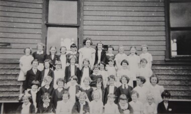 Westbourne Grammar Heritage Collection
Photograph - Students at Holy Trinity Hall 1954
This reproduction photograph was donated in 1986 during research for the first history of the school, 'The Westbourne and Williamstown Grammar Schools: A History of the First 120 Years (1867-1986)' by historian Joseph Johnson. It pictures female students in 1954. The students are pictured at Holy Trinity Hall which was situated behind the Holy Trinity Anglican Church, Nelson Place, Williamstown. The hall was located on the corner of Aitken and Pasco Streets, Williamstown, and was home to the school for 41 years from 3 February 1915. In 2008, Holy Trinity Williamstown approached the school to take possession of and relocate the heritage listed building, so that the church could redevelop its property.The relocation of Holy Trinity Hall was an enormous task and very large commitment by Westbourne Grammar to its heritage. Considerations included cost, relocation logistics, architectural conservation, modern building codes and educational facility standards. In 2010, after more than two years of process between the Anglican Church and Westbourne Grammar, including approval from Heritage Victoria and assistance from the Labour government's Building the Education Revolution program, the Holy Trinity Hall was moved to the Truganina campus and once again became a site of gathering and learning for Westbourne Grammar students. Black and white reproduction photograph. The image shows four rows of girls standing before a side wall of Holy Trinity Hall. A window is present behind the group of students and another window can be seen in the top right hand corner of the image.On the verso, "1954 Girls" in black ink and "79" in a circle in blue ink. -
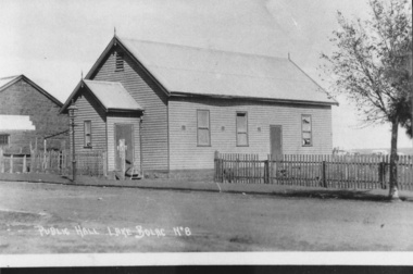 Lake Bolac & District Historical Society
Photograph - Black and white photograph, Lake Bolac Public Hall 1896, 1896
Lake Bolac Public Hall, Mongomery Street in 1896. Weatherboard construction by Mr Ollie Anderson of Ararat. Opened by district MP Mr McLellan. In 1922 this building was relocated across Montgomery Street to become the supper room for the newly erected Memorial Hall honouring World War 1 soldiers.black and white photographlake bolac, public hall, montgomery street, ollie anderson, mr mclellan -
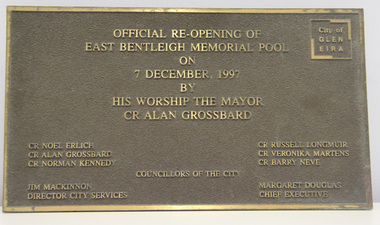 Glen Eira City Council History and Heritage Collection
Plaque, commemorative, c. 1997
Plaque was previously located on the front wall of the East Bentleigh Memorial Pool alongside the original City of Moorabbin Memorial Pool plaques. The plaques were removed from the wall when the building was demolished for the GESAC development. The Moorabbin pool plaques were restored and relocated to the rhs wall in the entrance to GESAC. Plaque, bronze rectangular with polished bronze border and relief lettering and brown textured background. The plaque commemorates the official re-opening of the East Bentleigh Memorial Pool by the Mayor, Cr Alan Grossbard in 1997.Polished bronze relief lettering in upper centre of plaque: "OFFICIAL RE-OPENING OF / EAST BENTLEIGH MEMORIAL POOL / ON / 7 DECEMBER, 1997 / BY / HIS WORSHIP THE MAYOR / CR ALAN GROSSBARD" lhs, rhs, centre: CR NOEL ERLICH / CR ALAN GROSSBARD / COUNCILLORS OF THE CITY / CR RUSSELL LONGMUIR / CR VERONIKA MARTENS / CR BARRY NEVE / JIM MACKINNON / DIRECTOR CITY SERVICES / MARGARET DOUGLAS / CHIEF EXECUTIVE" -
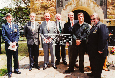
 Eltham District Historical Society Inc
Photograph, Rededication Ceremony, War Memorial Tower, Kangaroo Ground. 8 November 2001, 08/11/2001
L-R: Jim Wandin, (obscured), Richard ?, Governor John Landy, Mayor Cr. Sigmund Jorgensen, Harry Gilham, Fran Bailey M.P., Chaplain Des ? (Watsonia Army Barracks) (Contained in an album originally put together by Harry Gilham. Photos subsequently relocated to photosafe archival storage.) [2001]Colour photographkangaroo ground, war memorial tower, governor of victoria, harry gilham, john landy, rededication ceremony, sigmund jorgensen, fran bailey, jim wandin -
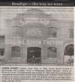 Bendigo Historical Society Inc.
Newspaper - JENNY FOLEY COLLECTION: QUEEN STREET
Bendigo Advertiser "The way we were" from 1999. Queen Street: factory, circa 1900. In 1893, Simon Brown formed a partnership with Charles Turner in Williamson Street, Bendigo, trading as Brown&Turner. The partnership had ceased by 1900 when the business was relocated to a modern two-storey brick building at 8-12 Queen Street where it traded as S. Brown & Company. With the gradual decline in carriage sales S. Brown & Companybecame motor dealers in about 1930 and continued to trade until the 1970s.newspaper, bendigo advertiser, the way we were -
 Kew Historical Society Inc
Photograph, Madford, Wellington Street, circa 1965, c. 1965
This work forms part of the collection assembled by the historian Dorothy Rogers, that was donated to the Kew Historical Society by her son John Rogers in 2015. The manuscripts, photographs, maps, and documents were sourced by her from both family and local collections or produced as references for her print publications. Many were directly used by Rogers in writing ‘Lovely Old Homes of Kew’ (1961) and 'A History of Kew' (1973), or the numerous articles on local history that she produced for suburban newspapers. Most of the photographs in the collection include detailed annotations in her hand. The Rogers Collection provides a comprehensive insight into the working habits of a historian in the 1960s and 1970s. Together it forms the largest privately-donated collection within the archives of the Kew Historical Society.‘Elm Lodge’ had a frontage to Wellington Street and extended to Cotham Road. It was renamed ‘Madford’ in 1874, after its purchase by the pastoralist Arthur Septimus King, the grandson of Philip Gidley King, third Governor of New South Wales. The Alexandra Gardens were developed on the northern section of Madford after the sale of the land to the Borough of Kew in 1905. King’s house, and the remaining garden, was sold to the Catholic Church in 1920, and subsequently developed into ‘St Anthony’s Home for Babies’ in 1922. The organisation relocated to Footscray in 1975, and the building demolished."Madford (formerly Elm Lodge) in Wellington Street Kew during the period when it was St. Anthony's Home for babies (now demolished). From the 1860s it had been the home of the King family. Harold Septimus King was one of the notable residents of Kew."madford, elm lodge, wellington street (kew), dorothy rogers -
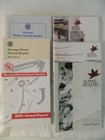 Kiewa Valley Historical Society
Reports - Annual Reports of Mt Beauty Hospital & Alpine Health, 1987 - 2004
The Tawonga & District Hospital was situated in Tawonga at the corner of Ryders Lane and the Kiewa Valley Highway. The construction was initiated by the Hospital & Charities Commission with considerable assistance from the SECV. It was officially opened in 1949. It was relocated to Mt Beauty in 1961. In 1997, the business combined with the hospitals in the Alpine Shire (Bright & Myrtleford) and became 'Alpine Health'.The annual reports of the local Mt Beauty hospital and associated health facilities gives an insight into its changes both medical and in its governance with its consequences to the small towns and district over the years.Booklets - Tawonga District General Hospital, Mt Beauty Annual Reports 1987 - 1996 and Booklets - Alpine Health - Bright, Mt Beauty Myrtleford Annual Reports 1997 - 2004tawonga & distrcit hospital, tawonga district general hospital, alpine health, mt beauty -
 Greensborough Historical Society
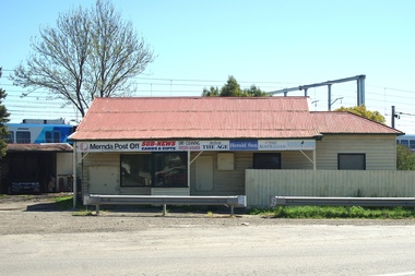
Photograph - Digital Image, Mernda Post Office 2018, 25/07/2019
In 2018 GHS members visited Turner's Bakery in Mernda for lunch and continued on to visit historic sites remaining in the Mernda area. This photograph shows the Mernda Post Office, formerly the Mernda General Store. It is sited in Schotters Road. Today the Post Office has been relocated to modern premises in Mernda Village Drive.Mernda is an area of rapid modern growth with a few remaining historic buildings dating from the 19th century.Digital copy of colour photographmernda, mernda historic sites, mernda post office, schotters road mernda, post offices, mernda general store -
 Eltham District Historical Society Inc
Photograph, The Advisory Committee of the Park and Tower, Rededication Ceremony, War Memorial Tower, Kangaroo Ground. 8 November 2001, 08/11/2001
L-R: Nicholas Pelling, Harry Gillham (Convenor of the Advisory Committee of the Park and Tower), Governor John Landy, Mick Woiwod, Dennis Ward, Dean Stewart, Mayor Cr. Sigmund Jorgensen. (Contained in an album originally put together by Harry Gilham. Photos subsequently relocated to photosafe archival storage.) [2001]Colour photographkangaroo ground, war memorial tower, rededication ceremony, dean stewart, dennis ward, governor of victoria, harry gilham, john landy, mick woiwod, nicholas pelling, sigmund jorgensen -
 Hume City Civic Collection
Photograph, c 1993
Aitkens Gap Police Lock up was originally constructed at The Gap which was south of the junction of Gap Road (Sunbury Road) and Calder Highway (Victoria St/Mt. Alexander Road). It was part of a police complex which was a changeover station for the gaol escort. The goal was relocated and rebuilt in the police station grounds in Sunbury in 1993.A coloured photograph of five men working on the removal of Aitkens Gap Gaol from its original site. Two end walls of the gaol are standing and the work is being done on the front and back of the building. Conifers and cypress trees are growing around the site.peter free, aitkens gap gaol, police historical association, sunbury police station, george evans collection -
 8th/13th Victorian Mounted Rifles Regimental Collection
Photograph - NCOs with Philip, 1954
This and another photograph (Catalogue 2591) was taken at a gathering of Officers and NCOs of the 2nd Armoured Brigade (RAAC) to meet Prince Philip in Melbourne during the Royal Visit 1954. The two photographs were framed and hung on the wall of the Headquarter Building at Buna Barracks Albury till 1991 when they were relocated to the Regimental Collection.Rare record of an historic gathering during the Royal Visit to Victoria in1954.Framed black and white photograph of large gathering of soldiers in uniform standing on steps of a Government House Melbourne. Frame is narrow wood painted gloss black. The group is the Non-Commissioned Officers of the 2nd Armoured Brigade, Royal Australian Armoured Corps (RAAC). Standing at front centre dress in dark suit is HRH Prince Philip Duke of Edinburgh and to his right is Lieutenant Colonel Tom Fogarty, Commanding Officer of 8/13 Victorian Mounted Rifles..Signed at lower centre "Philip 1954"philip, hrh, edinburgh, fogarty, royal -
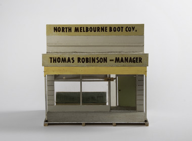 Port Fairy Historical Society Museum and Archives
Mixed media - Model, North Melbourne Boot Co, early 1970`s
This model was part of a panorama 11 pieces designs from photos in an almanac printed by Port Fairy Gazette. The panorama was used by the Historical Society rooms Bank Street as a display on an extended mantel piece, before being relocated to Gipps Street. It was made by Mr Alan Mewkill a member of the Port Fairy Historical Society.This model depicts in 3D, part of the streetscape of Port Fairy in 1892 as drawn in a calendar/almanac of the time. Small hand made model of a shop front form the 1892 almanacThomas Robinson - Managerpanorama, model, bank street, sackville street, mr t robinson, alan mewkill -
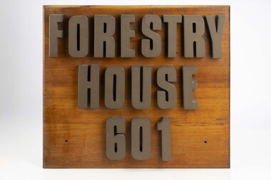 Department of Energy, Environment and Climate Action
Forestry House Sign
Forestry House was the fist time that Forests Commission Head office staff had been housed in a purpose built building in Melbourne 601 Bourke street is on the corner of Bourke and King streets The building opened in the late 1970s but staff relocated in the late 1980s after the formation of the Department of Conservation Forests and Lands (CFL)Large wooden sigh from outside Forestry House at 601 Bourke Streetforests commission victoria (fcv), forest signs -
 Ringwood and District Historical Society
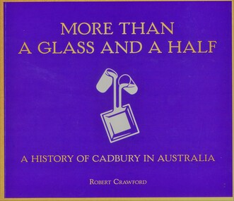
Book, Robert Crawford, More Than A Glass And A Half - A History Of Cadbury In Australia, 2022
In July 1967, Cadbury-Fry-Pascall announced that its offer to buy a majority stake in MacRobertson (Australia) Limited had been accepted. Cadbury's acquisition of MacRobertson provided a new factory and offices in Canterbury Road, Ringwood. Management and administration staff relocated from Tasmania, marking a new chapter in the firm's development.Soft-covered purple book with gold lettering and white Cadbury logo. (176 pages) -
 Melbourne Tram Museum
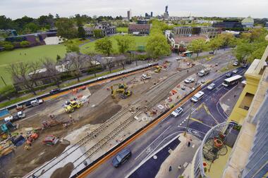
Photograph - Digital Image, Public Transport Victoria (PTV), "St Kilda Road and High Street - Buses replace trams - Sunday 13 Oct. to Sunday 27 Oct.", Oct. 2019
.1 - Pamphlet - 2 x 3 fold x titled "St Kilda Road and High Street - Buses replace trams - Sunday 13 Oct. to Sunday 27 Oct." 2019 for works at Domain, Park and St Kilda Road and track relay in High Street between St Kilda Road and Williams Road. Gives alternative bus routes. Part of the work was for the construction of the Noise Box or acoustic shed over the future Anzac Station site - part of the Metro Tunnel Works and track relocation. See htd3930i2.pdf for a detailed description of the work from the Metro Tunnel authority - Rail Projects Vic. This file does not want to open properly using dbtext works, access directly. Image i3 - from tdu website https://tdu.to/m/262235/re-d2-5005-at-temporary-tram-termin-us-st-kilda-road, shows the works underway. Posted by Metro Tunnel on twitter today showing progress on relocating tram tracks at site of Anzac station. This will allow construction of the southern box of the station. Large file (~2.6MB and 4096x2733 pixels, but enables you to get "up close and personal".trams, tramways, park st, domain junction, metro tunnel, toorak rd, st kilda rd, tramway construction -
 Port Fairy Historical Society Museum and Archives
Decorative object - Model, c.1970
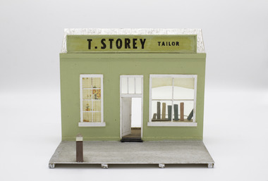
This model was part of a panorama consisting of 11 pieces designed from drawings in an 1892 almanac printed by Port Fairy Gazette The panorama was used in the Historical Society rooms in Bank St. On an extended mantel piece, before being relocate to Gipps Street. It was made by a member of the Port Fairy Historical Society Mr Allan mewkill.This model was made as a part of an eleven piece panorama of the streetscape of Port Fairy in 1892. By a local resident of the town.Small hand made model of a shop front from the 1892 almanac. T. Storey Taiiormodel, bank street, almanac, alan mewkill, t.storey, tailor -
 Warrnambool and District Historical Society Inc.
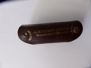
Key holder, Parker Bros Auto Co Key Holder, Mid 20th century
The Parker Bros Auto Company was established in 1927 in Liebig Street, with the business selling Chevrolet cars and used cars and later becoming the original Holden dealer in Warrnambool. The company employed a large staff with show rooms, a workshop, a panel shop, and a spare parts section. In 1968 the business relocated to 109 Lava Street and was still operating in the 1980s.This key ring holder is of great interest as a souvenir of Parker Bros. Auto Co, a prominent business in Warrnambool for over 50 years.This is a brown leather key holder issued as an advertising feature by Parker Bros Auto Co. Warrnambool. The key holder is folded over to include a metal bottle opener which is held to the leather with a metal stud and a metal press stud enables the holder to be locked shut. There are two holes at the end to attach keys to the holder. The printing on the holder is in gold lettering. ‘Ignition’, ‘Door’, ‘Home’, ‘Office’ ‘Auto Keys’ ‘Parker Bros. Auto Co. Warrnambool Phone 627’ parker bros auto co warrnambool, history of warrnambool -
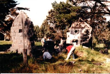
 Eltham District Historical Society Inc
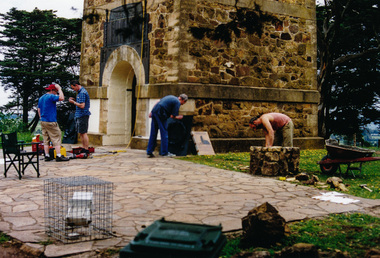
Photograph, Bronze Plaques being set in place, War Memorial Tower, Kangaroo Ground, 5 November 2001, 05/11/2001
Three days before the rededication ceremony. The bronze plaques are being put in place by Meridian Foundry. The stonemason is copying the tower wall as a base for the brass etching by Paul Smith of Kenneth Jack's 1943 sketch of the Tower. (Contained in an album originally put together by Harry Gilham. Photos subsequently relocated to photosafe archival storage.) [2001]Colour photographkangaroo ground, war memorial tower -
 Grey Street Primary School, Traralgon
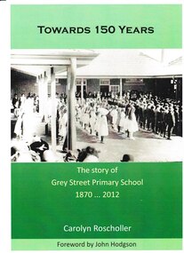
Book, Towards 150 Years. The story of Grey Street Primary School 1870 ... 2012, 2012
Commissioned to be written in 2012 to coincide with the centenary of the opening of the school at the new site in Grey Street, Traralgon. Includes historical information on the first school in Argyle Street in 1870, and its relocation to Campbell Street in 1872. Chapters are set out in decades. Many historical photos of various classes most of which include pupil and staff names.This book tells the story of the commencement of state education in Traralgon in 1870, and follows the development of Traralgon State School into the present Grey Street Primary School.A4. Cover photo depicting children in quadrangle at official opening of Grey Street Primary School in 1912. Cover printed in full process both sides. Text printed in Black throughout, except 16pp colour, perfect bound and packed. Cover: Towards 150 Years/ The story of/ Grey Street Primary School/ 1870 ... 2012/ Carolyn Roscholler/ Foreword by John Hodgson Spine: Towards 150 Years - Carolyn Roscholler Complete typesetting by Gippsland Printers.grey street., traralgon state school, campbell street, traralgon -
 Hume City Civic Collection
Photograph
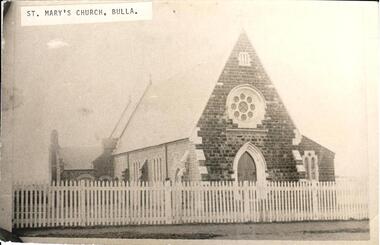
St. Marys Catholic Church is now known as Our Lady of Mt. Carmel in Macedon Street, Sunbury. From information written on the back of the photograph it was believed to be the Presbyterian Church Bulla. This being the case, it was relocated because of the construction of the International Airport. Sir Henry Winneke probably re-opened the Bulla Church on 24 November 1975.A black and white photograph of a blustone church behind a picket fence known as St. Marys Catholic Church Sunbury but has been incorrectly labelled as St. Marys Catholic Church Bulla.top LH corner on piece of paper pasted and type written : St. Marys Church Bullast mary's catholic church, our lady of mt carmel church, churches, sunbury, bulla, macedon street, winneke, henry (sir), 1970s, george evans collection -
 Mt Dandenong & District Historical Society Inc.
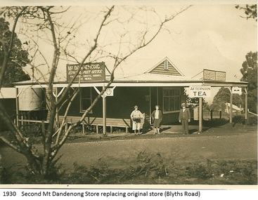
Photograph, Mt Dandenong Store, 1930
Image shows the Mt Dandenong Store and Post Office that replaced the former Post office and Store that was located on the corner of Old Coach and Farndons Roads. The store relocated following the opening of the new Main Road in 1926. The store pictured was on the corner of Helen Street and the Main Road. The image was taken in 1930. The photograph was taken by a member of the Dower family.Donated as a jpeg digital image that shows the Mt Dandenong Store on the corner of Helen Street and the Main Road in 1930. Two women and a man are standing at the front. Signs advertising the Store & Post Office, Age and Argus are clearly visible on top of the verandah.Front of image: 1930 Second Mt Dandenong Store replacing original store (Blyths Road)mt dandenong, post office, store, mt dandenong store, main road -
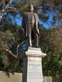 Bayside Gallery - Bayside City Council Art & Heritage Collection
Sculpture, Margaret Baskerville, Sir Thomas Bent, 1913
Arguably Margaret Baskerville’s most famous work, the bronze statue of politician and land speculator Sir Thomas Bent was Baskerville’s first public commission and a significant turning point in her career. Originally located in the centre of the Nepean Highway, in Brighton, it became somewhat of signpost for many Melbournians until it was relocated to the corner of Bay Street in 1980.The statue of Sir Thomas Bent is of historic and social significance to the State of Victoria. The statue is historically significant for commemorating Bent's long, active and infamous political career in Victoria. He was responsible for many important speculative ventures both within his electorate and in the wider context of Victoria. Although not without thought for personal gain, Bent was a committed advocate of public utilities, railways, roads, tramways and gasworks. The statue is historically significant as the first large public commission given to a woman sculptor in Victoria. This work helped the sculptor, Margaret Baskerville, preserve her name as Victoria's first professional woman sculptor. The statue is socially significant as testimony to the late nineteenth century land boom and the financial and political corruption and scandals that accompanied it. https://vhd.heritagecouncil.vic.gov.au/places/12614bronze and granite thomas bent, politician, mayor, premier, bust, sculpture, margaret baskerville, speaker, member of parliament, member of lower house, local government, councillor, brighton, public art, bayside -
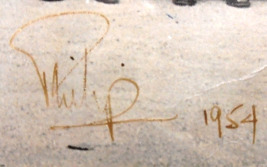 8th/13th Victorian Mounted Rifles Regimental Collection
Photograph - VMR Officers with Philip, 1954 circa
This and another photograph (Catalogue 3393) was taken at a gathering of Officers and NCOs of the 2nd Armoured Brigade (RAAC) to meet Prince Philip at Government House, Melbourne during the Royal Visit 1954. The two photographs were framed and hung on the wall of the Headquarter Building at Buna Barracks Albury till 1991 when they were relocated to the Regimental Collection.Rare record of an historic gathering during the Royal Visit to Victoria in1954.Framed black and white photograph of large gathering of soldiers in uniform standing on steps of Government House, Melbourne. The group is the officers of the 2nd Armoured Brigade, Royal Australian Armoured Corps (RAAC). Lieutenant Colonel Tom Fogarty, Commanding Officer 8/13 Victorian Mounted Rifles, is standing on HRH Prince Philip Duke of Edinburgh's right. Signed at lower centre of photograph "Philip 1954"2nd armoured brigade, prince philip duke of edinburgh, fogarty tom lieutenant colonel, martin arch warrent officer class 1, royal visit 1954