Showing 902 items
matching reservoirs
-
 Eltham District Historical Society Inc
Photograph, Hume and Hovell Monument, Memorial Park Sports Ground, Whorouly, c.1998, 1998c
Stage 3 tour of Hume and Hovell monuments organised by Russell Yeoman. At the centenary of Hume and Hovell exploration in 1924 a committee was formed to co-ordinate and organise local celebrations along the route from Albury to Corio Bay. An itinerary was created for the unveiling ceremonies giving the hour and date for each place concerned from 15 to 21 November 1924. Thirty-three monuments or cairns were erected at Violet Town, Euroa, Avenel, Seymour, Broadford, Kilmore, Mount Bland, Bulla, Moyhu, Hansonville, Benalla, Samaria, Swanpool, Yarck, Yea, The Horn (Buffalo), Myrtleford, Whorouly, Everton, Murmungee, Stanley, Back Creek, Allan's Flat, Staghorn Flat, Ebden, Bethanga, Hume Reservoir, Strath Creek, Deer Park, Werribee, Lara, Bulla, Everton.Roll of 35mm colour negative film, 7 stripsKodak Gold 200-6activities, back creek, hume and hovell, monument -
 Kew Historical Society Inc
Photograph - Yarra Valley Floods: Kew East, 1916
Flooding of the Yarra Valley, including that section of the Yarra bordering Kew and Kew East in the north and west of the municipality, was a regular occurrence. Extreme flood events of the Yarra River are recorded to have occurred in 1891, 1901, 1916, 1923 and 1934. The Municipality of Kew's response to these floods was to enact planning decisions restricting residential development in flood prone areas following the floods of 1916, 1921 and 1934. While floods continued after the development of the Upper Yarra Reservoir (construction 1948-57), the regularity and extent of these inundations diminished. During the nineteenth century, the land abutting the south side of the Yarra in Kew was devoted to dairy farming. In the twentieth century, before and after the construction of the Eastern Freeway, much of this low-lying area was used as golf courses and public parks.One of a collection of photographs of flooding in the Kew section of the Yarra Valley which are in important research resource for the location and extent of flooding in the first half of the twentieth century. Flooding of the Yarra Valley at East Kew in 1916. The view is taken from the intersection of Kilby Road with what is believed to be Birdwood Street, looking across the flood waters to Ivanhoe. The extensive flooded area shown in the photograph would have included the Kew Golf Club. Verso: "Floods along Kilby Road / near Birdwood St? & Kilby Road / 1917? / 87yarra river, yarra valley, floods -- kew, kilby road -- kew (vic.), kew golf club -
 Kew Historical Society Inc
Photograph - Yarra Valley Floods: Kew East, 1916
Flooding of the Yarra Valley, including that section of the Yarra bordering Kew and Kew East in the north and west of the municipality, was a regular occurrence. Extreme flood events of the Yarra River are recorded to have occurred in 1891, 1901, 1916, 1923 and 1934. The Municipality of Kew's response to these floods was to enact planning decisions restricting residential development in flood prone areas following the floods of 1916, 1921 and 1934. While floods continued after the development of the Upper Yarra Reservoir (construction 1948-57), the regularity and extent of these inundations diminished. During the nineteenth century, the land abutting the south side of the Yarra in Kew was devoted to dairy farming. In the twentieth century, before and after the construction of the Eastern Freeway, much of this low-lying area was used as golf courses and public parks.One of a collection of photographs of flooding in the Kew section of the Yarra Valley which are in important research resource for the location and extent of flooding in the first half of the twentieth century. Flooding of the Yarra Valley at East Kew in 1916. The view is taken from a street (maybe Birdwood Avenue) intersecting with Kilby Road looking northeast across the flood waters to Ivanhoe and Heidelberg. The extensive flooded area shown in the photograph would have included remnant dairy farms and the Kew Golf Club. Verso: "Floods / Yarra River / East Kew / Kilby Road / 1917? / 87"yarra river, yarra valley, floods -- kew, kilby road -- kew (vic.), kew golf club -
 Kew Historical Society Inc
Photograph - Flooding of the Yarra Valley at Kew East, 1974
Flooding of the Yarra Valley, including that section of the Yarra bordering Kew and Kew East in the north and west of the municipality, was a regular occurrence. Extreme flood events of the Yarra River are recorded to have occurred in 1891, 1901, 1916, 1923 and 1934. The Municipality of Kew's response to these floods was to enact planning decisions restricting residential development in flood prone areas following the floods of 1916, 1921 and 1934. While floods continued after the development of the Upper Yarra Reservoir (construction 1948-57), the regularity and extent of these inundations diminished. During the nineteenth century, the land abutting the south side of the Yarra in Kew was devoted to dairy farming. In the twentieth century, before and after the construction of the Eastern Freeway, much of this low-lying area was used as golf courses and public parks.Late example of the capacity of the Yarra Valley at Kew to flood, even though drainage works and the Upper Yarra Reservoir had reduced their regularity.Original black and white print photograph of the low-lying land at East Kew under floodwater on 16 May 1974. The vantage point of the photographer is Lister Street. In the photo, the fences of the Kilby Farm can be seen. Flooding was caused by overflowing water in Glass' Creek and the River Yarra. Annotation verso: "Hay's Paddock op No.30 Lister Street / 16 May 1974 11.50am / R.L. 46.04"hays paddock, floods, yarra river, glass' creek, lister street -
 Kew Historical Society Inc
Photograph - Flooding of the Yarra Valley at Kew East, 1974
Flooding of the Yarra Valley, including that section of the Yarra bordering Kew and Kew East in the north and west of the municipality, was a regular occurrence. Extreme flood events of the Yarra River are recorded to have occurred in 1891, 1901, 1916, 1923 and 1934. The Municipality of Kew's response to these floods was to enact planning decisions restricting residential development in flood prone areas following the floods of 1916, 1921 and 1934. While floods continued after the development of the Upper Yarra Reservoir (construction 1948-57), the regularity and extent of these inundations diminished. During the nineteenth century, the land abutting the south side of the Yarra in Kew was devoted to dairy farming. In the twentieth century, before and after the construction of the Eastern Freeway, much of this low-lying area was used as golf courses and public parks.Late example of the capacity of the Yarra Valley at Kew to flood, even though drainage works and the Upper Yarra Reservoir had reduced their regularity.Original black and white print photograph of the low-lying land at East Kew under floodwater on 16 May 1974. The vantage point of the photographer is Lister Street. Flooding was caused by overflowing water in Glass' Creek and the River Yarra. Annotation verso: "Lister Street looking north / Flood level / 16 May 1974 11.30am / R.L. 46.04"hays paddock, floods, yarra river, glass' creek, lister street -
 Kew Historical Society Inc
Photograph - Flooding of the Yarra Valley at Kew East, 1974
Flooding of the Yarra Valley, including that section of the Yarra bordering Kew and Kew East in the north and west of the municipality, was a regular occurrence. Extreme flood events of the Yarra River are recorded to have occurred in 1891, 1901, 1916, 1923 and 1934. The Municipality of Kew's response to these floods was to enact planning decisions restricting residential development in flood prone areas following the floods of 1916, 1921 and 1934. While floods continued after the development of the Upper Yarra Reservoir (construction 1948-57), the regularity and extent of these inundations diminished. During the nineteenth century, the land abutting the south side of the Yarra in Kew was devoted to dairy farming. In the twentieth century, before and after the construction of the Eastern Freeway, much of this low-lying area was used as golf courses and public parks.Late example of the capacity of the Yarra Valley at Kew to flood, even though drainage works and the Upper Yarra Reservoir had reduced their regularity.Original black and white print photograph of Hay's Paddock under floodwater on 16 May 1974. The vantage point of the photographer is Keystone Crescent looking east. Flooding was caused by overflowing water in Glass' Creek and the River Yarra. Annotation verso: "Keystone Cr looking east / 16 May 1974 11.50am"hays paddock, floods, yarra river, glass' creek -
 Kew Historical Society Inc
Photograph - Flooding of the Yarra Valley at Kew East, 1974
Flooding of the Yarra Valley, including that section of the Yarra bordering Kew and Kew East in the north and west of the municipality, was a regular occurrence. Extreme flood events of the Yarra River are recorded to have occurred in 1891, 1901, 1916, 1923 and 1934. The Municipality of Kew's response to these floods was to enact planning decisions restricting residential development in flood prone areas following the floods of 1916, 1921 and 1934. While floods continued after the development of the Upper Yarra Reservoir (construction 1948-57), the regularity and extent of these inundations diminished. During the nineteenth century, the land abutting the south side of the Yarra in Kew was devoted to dairy farming. In the twentieth century, before and after the construction of the Eastern Freeway, much of this low-lying area was used as golf courses and public parks.Late example of the capacity of the Yarra Valley at Kew to flood, even though drainage works and the Upper Yarra Reservoir had reduced their regularity.Original black and white print photograph of the low-lying land at East Kew under floodwater on 16 May 1974. The vantage point of the photographer is Lister Street. Flooding was caused by overflowing water in Glass' Creek and the River Yarra. Annotation verso: "Lister St looking same as No.3 / 16 May 1974 11.30"floods, yarra river, glass' creek, lister street -
 Kew Historical Society Inc
Photograph - Flooding of the Yarra Valley at Kew East, 1974
Flooding of the Yarra Valley, including that section of the Yarra bordering Kew and Kew East in the north and west of the municipality, was a regular occurrence. Extreme flood events of the Yarra River are recorded to have occurred in 1891, 1901, 1916, 1923 and 1934. The Municipality of Kew's response to these floods was to enact planning decisions restricting residential development in flood prone areas following the floods of 1916, 1921 and 1934. While floods continued after the development of the Upper Yarra Reservoir (construction 1948-57), the regularity and extent of these inundations diminished. During the nineteenth century, the land abutting the south side of the Yarra in Kew was devoted to dairy farming. In the twentieth century, before and after the construction of the Eastern Freeway, much of this low-lying area was used as golf courses and public parks.Late example of the capacity of the Yarra Valley at Kew to flood, even though drainage works and the Upper Yarra Reservoir had reduced their regularity.Original black and white print photograph of the low-lying land at East Kew under floodwater on 16 May 1974. The vantage point of the photographer is at Willsmere Road. The road itself is underwater.Annotation verso: "Willsmere Rd / Same as No.7 / 16 May 1974 11.15am"floods, yarra river, willsmere road -
 Kew Historical Society Inc
Photograph - Flooding of the Yarra Valley at Kew East, 1974
Flooding of the Yarra Valley, including that section of the Yarra bordering Kew and Kew East in the north and west of the municipality, was a regular occurrence. Extreme flood events of the Yarra River are recorded to have occurred in 1891, 1901, 1916, 1923 and 1934. The Municipality of Kew's response to these floods was to enact planning decisions restricting residential development in flood prone areas following the floods of 1916, 1921 and 1934. While floods continued after the development of the Upper Yarra Reservoir (construction 1948-57), the regularity and extent of these inundations diminished. During the nineteenth century, the land abutting the south side of the Yarra in Kew was devoted to dairy farming. In the twentieth century, before and after the construction of the Eastern Freeway, much of this low-lying area was used as golf courses and public parks.Late example of the capacity of the Yarra Valley at Kew to flood, even though drainage works and the Upper Yarra Reservoir had reduced their regularity.Original black and white print photograph of the low-lying land at East Kew under floodwater on 16 May 1974. The photograph is of Hyde Park looking north-east.Annotation verso: "Hyde Park looking nth-east / Flood Level / 16 May 1974 11.15am / R.L. 46.61"floods, yarra river, hyde park -
 Kew Historical Society Inc
Photograph - Flooding of the Yarra Valley at Kew, 1974
Flooding of the Yarra Valley, including that section of the Yarra bordering Kew and Kew East in the north and west of the municipality, was a regular occurrence. Extreme flood events of the Yarra River are recorded to have occurred in 1891, 1901, 1916, 1923 and 1934. The Municipality of Kew's response to these floods was to enact planning decisions restricting residential development in flood prone areas following the floods of 1916, 1921 and 1934. While floods continued after the development of the Upper Yarra Reservoir (construction 1948-57), the regularity and extent of these inundations diminished. During the nineteenth century, the land abutting the south side of the Yarra in Kew was devoted to dairy farming. In the twentieth century, before and after the construction of the Eastern Freeway, much of this low-lying area was used as golf courses and public parks.Late example of the capacity of the Yarra Valley at Kew to flood, even though drainage works and the Upper Yarra Reservoir had reduced their regularity.Original black and white print photograph of the low-lying land at East Kew under floodwater on 16 May 1974. The photograph is taken from 43 Kellett Grove.Annotation verso: "Kellett Gve No.43 / Flood Level / 16 May 1974 11.40am"floods, yarra river, kellett grove -
 Vision Australia
Administrative record - Text, 72nd Annual Report 1965 - 1966 Braille Library of Victoria, 1966
Articles include the production of Christmas cards for purchase, a visit by the Chief Secretary Hon. A. Rylah who advised that the Free Library Scheme was for municipal councils and that instead a State Library Council (which was being formed) would be a better source of relief, offers of help to contact potential overseas suppliers for electronic and braille equipment, the organisation of the Reservoir auxiliary, establishment of a Machines Committee to look at mechanized forms of Braille production and the possibility of entering into talking book production, improvements to heating, cooking and lighting, needing to use discretion when hiring hall due to an unfortunate incident, donations of Perkins Braillers, brailling of Decimal conversion charts, agreement in prinicipal to a National Braille Reference Library in Canberra, and purchase of Perkins and Stainsby Braillers to improve output of Braille books.32 pages of text with drawingsbraille library of victoria, corporation records -
 Kiewa Valley Historical Society
Postcard - Mt Beauty and the Kiewa Hydro Electric Scheme
SECV constructed the Kiewa Hydro Electric Scheme including the township of Mt Beauty. The area became a popular tourist destination.Tourism in the Kiewa Valley especially at Mt Beauty and the Bogong High Plains along with the Kiewa Hydro Electric Scheme became very popular and an important industry.Fold out b & w postcard with 12 photos back to back. All with a title. Kate 1950s 1. High Voltage Transmission Line, showing Mount Beauty Township 2. Clover Dam Reservoir, Kiewa 3. No. 3 Power Station, Kiewa 4. Generators, No. 3 Power Station 5. Turbines, No. 4 Power Station, Kiewa 6. junction Dam, Bogong 7. Mt Beauty Village Shopping Centre 8. Switchyard, No. 4 Power Station, Kiewa 9. Control Room, No. 4 Power Station, Kiewa 10. Winter Scene at Rocky Valley on the Bogong High Plains 11. Water Channel, Mt Bogong in Background 12. Mt Beauty Township, Kiewa Valleytransmission line, power station, generators, mt beauty, turbines, junction dam, switchyard, rocky valley, control room -
 Southern Sherbrooke Historical Society Inc.
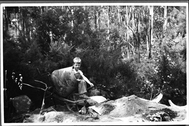
Photograph - Terry Smith at the building site of the caretaker's house, Belgrave Reservoir, c.1940s
Black and white photo of Terry Smith, Pam Harris's younger brother, aged about 6 or 7, during the building of a septic tank for the caretaker's house at Belgrave Lake Park. Terry is sitting in a concrete mixer. On the ground are bags of concrete. A pile of sand is on a tarpaulin. Behind Terry there are shrubs and small trees and behind them are tall trees on a steep hillside. The Belgrave Reservoir is at the bottom of the slope. A house can be seen in the distance, possibly the house visible in B0399. Terry and Pam's father, Oscar Smith, built the caretaker's house, selling it in 1960 for £1250. The photo probably dates to the 1940s and is part of a collection of family photos donated by Pam Harris, Shire of Sherbrooke President, 1982-1983 & 1987-1988. -
 Melton City Libraries
Photograph, Melton Railway Bridge, c.1884
"The Melton Viaduct, opened in 1886, is of State heritage significance as a very large and visually distinctive wrought iron, lattice girder trestle bridge over the Werribee River (now Melton Reservoir). It comprises 18.3 and 9.1 metre spans, in a generally alternate arrangement, of total length 375 metres, and standing 38 metres over the Werribee River. Wrought iron small section iron was used to build tension trussed trestle legs, which supported four lines of rivetted wrought-iron deck-type double lattice trusses. It has bluestone abutments and pier bases of coursed rock-faced bluestone with drafted margins. The larger half-piers, now usually submerged in the Melton Reservoir have sharp tapered cutwaters and curved coping at the tops. While designed to carry two rail tracks it has only ever been used as a single track line. Despite several alterations to its deck structure, it remains an outstanding example of a lighter structural design employing open metal trestle supports and metal truss girders. The direct Melbourne to Ballarat railway link of which the Melton viaduct was the major engineering work contributed significantly to the history and development of Victoria. This new link reflected Ballarat’s diversifying economy as well as the commercial and political influence of the metropolis. Construction of the bridge, and the associated large workers camp, were extensively photographed, documenting an important episode in local history. The railway enabled the development of new industries in the Melton area, notably the timber industry and a chaff industry of national importance, greatly facilitated the later transition of the Shire from a pastoral to a farming economy, and struck a major blow to Melton township’s era as a wayside town servicing Ballarat road (especially coach) traffic". Melton Railway Bridge being built across the Werribee Rivertransport -
 Federation University Historical Collection
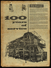
Newspaper, The Courier, 100 years of service, 1967, 10/06/1967
... reservoirs ...The newspaper was produced to celebrate the 100th year of the Ballarat Courier.96 page newspaper celebrating 100 years of publishing the Ballarat Courier Newspaper. Stories and images include: Robert Clark, Ballarat history, Sturt Street, Selkirk Bricks, Ballarat Industry, Thomas Bath, Royal Hotel, hotels, Begonia Festival, James Smith, Hollways, Myers, Ballarat Orphanage, Nazareth House, Lake Elsworth, Batches, libraries, Timken, Sunshine Biscuits, M.B. John, AMCAST, reservoirs, Ballarat Council,, Morsheads, Civic Hall, Alfred Hall, Art Gallery, Christies, 3BA, Paddle Bros, South Street, BTV 6, Memorial Theatre, Her Majesty's, Whitelaw-Monier, Coltman, costume, Messer and opie, politics, Dudley Erwin, Bill Stephen, Vance Dickie, Tom Evans, Murray Byrne, McKay - Macleod, Crockers, Ballarat Shire, Sovereign Hill. St Patrick's Cathedral, Christ Church Cathedral, Ballarat School of Mines, Mt Helen Campus, Ballarat Girls School. Ballarat North Technical School , Burke and Wills Memorial, Joe White Maltings, Ballarat Airport, Sunicrust, architecture, women, trams, transport, Faulls, Franklin Caravans, Olympics, football, history of Sunshine Biscuits robert clark, clark, ballarat, sturt street, selkirk bricks, industry, thomas bath, royal hotel, hotels, begonia festival, james smith, hollways, myers, ballarat orphanage, nazareth house, lake elsworth, batches, libraries, timken, sunshine biscuits, m.b. john, amcast, reservoirs, ballarat council, morsheads, civic hall, alfred hall, art gallery, christies, 3ba, paddle bros, south street, btv 6, memorial theatre, her majesty's, whitelaw-monier, coltman, costume, messer and opie, politics, dudley erwin, bill stephen, vance dickie, tom evans, murray byrne, mckay - macleod, crockers, ballarat shire, sovereign hill. st patrick's cathedral, christ church cathedral, ballarat school of mines, churches, mt helen campus, ballarat girls school. ballarat north technical school, burke and wills memorial, joe white maltings, ballarat airport, sunicrust, architecture, women, trams, transport, faulls, franklin caravans, olympics, football, bray raceway, coliseum motors, schoools, education, craig bros, dayelsford, clunes, beaufort, linton, skipton, heinz bors, villiers, flecnoe, jones, robertson, cowles, bulless, cronn, matthews, ballarat library, cowley's eureka iron works, john hollway and sons, ken webb, mayoral chain, ken flecknoe, a.e. flecknoe, bath's hotel, eureka stockade memorial park -
 Kiewa Valley Historical Society
Ink Well Desk Set, circa mid to late 1900's
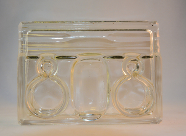
The "nib" pen was the preferred scribe method up until the "fountain" pen was produced (1940's), both could use specific inks that had longer life periods on paper surfaces. Ink wells such as those incorporated in this desk set allowed the user to select the colour and "type of ink" required. The nib pen was the only writing pen that could tolerate "Iron gall" ink. Legal documents were at the start of the mid 1980's required by law(in Australia) to be signed by "well" filled pens. The inks used were either "indian" or "iron/oak gall" because their infusion into paper could not be erased and they had a longer "paper" life and were harder to forge. Bottled ink was superior to that supplied in fountain pens or "biro pens" because the user's choice to a greater range of inks covered a variety of scenarios. Forging a nib signature is extremely hard compared to that of a "biro pen" because a nib settles in to the users particular style of pen movement and arm pressure.This desk writing set was typical of those used by administrators, businesses or quasi legal sectors within the Kiewa Valley, before the lifting of the ban on the use of biros "to sign" legal documents. Fountain pens were used extensively before cheaper biros (throw away) writing implements (1940's) came into the market place.This glass ink well desk set has two circular ink wells connected to their respective nib holders. The nib holders are smaller circular receptacles and feed off the larger ink reservoirs. Between the two larger ink wells is a shallow bottomed elongated "oval" sphere able to contain "slide on" clips, two pronged fasteners (require a hole to be punched in papers) or small "bulldog" clips. At the front edge is an elongated and grooved (two) place for writing nibs. The grooves keep each nib or fountain pen separated.The glass structure is made from clear glass and only the outside "boxed" walls of the desk set make contact with the desk surface. The ink wells can also securely accommodate small bottles of ink. This would have been the case for refillable fountain pens.stationery, fountain pens, nib pens, ink receptors, glass ink wells -
 Kiewa Valley Historical Society
Lamp Small Kerosene, circa early 1900s
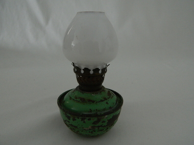
The period when kerosene was extensively used for indoor lighting was before electrical reticulation was installed in rural areas. In remote areas this was up to the mid 1900's. The kerosene lantern however was still in use, for camping and outdoor activities, well beyond this period and was eventually replaced by LPG and battery powered lighting. The transition phase to "modern" outdoor and domestic lighting lingered on the rural areas where the electrical reticulation suffered from reliable constant supply.In the Kiewa Valley, being a rural region, had reliable electrical domestic and farm supply only after the Kiewa Hydro Electricity Scheme had been fully operational. The supply was relative to how close the homestead was to the major electricity substation. This kerosene lamp was in use during the period when it was the only reliable source of domestic night time lighting. The strength of refractive light produced by this lantern/lamp hinged upon the size of the lamp(wick and glass bowl). The small size of this lamp suggests that it was for use in a small room(children's bedroom) or as providing a light for a safe walk to the outside ablutions (toilet) area. This small kerosene lamp has an enclosed "cup" body which would have contained the kerosene fuel. The top wick holder, made from brass, has an extended enclosed spout which raises the wick approximately 20mm from the bottom of the holder. The wick holder screws into the the top of the kerosene reservoir bowl and has a wick adjustment screw (light control) at one side. The small white glass light reflector bulb nestles securely onto the wick holder and is kept snug by snap designed extending "fingers". The section between the bottom of the refractive glass "light" bowl and the top of the kerosene bowl has perforations to allow air passage to feed directly to the wick.The light refracting bulb is open at the top to allow heat and smoke from the burning wick to escape upwards.On the wick control screw "CWB BRITISH MADE"kerosene reading lamp, domestic lighting, bedside light -
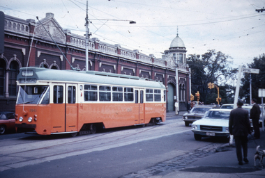 Melbourne Tram Museum
Slide - Set of 4, Dave Menzies?, 19/04/1973 12:00:00 AM
Set of four colour slides of PCC car 1041 on its debut trip, but that broke down at the corner of Gertrude and Nicholson St. TMSV copy slides. Photographer unknown. Dated 19/4/1973. .1 - In Nicholson St with the Cable Tram winding house in the background. .2 - 1041 reversing and about to pass through the crossover. Has a W tram at the other end that has cleared the tram from the cross over shown in the first slide. .3 - has a W class tram at the rear - could be out of order. .4 - Being towed by W7 1001 in Queens Parade under the Reservoir railway line railway bridge. advertising Stegbar windows and Stott & Son Real Estate. See also Reg Item 6043 for other photos.Keith has written details on each slide including the date and the "TMSV" stamp.trams, tramways, gertrude st, new tramcars, winding houses, tram 1041, pcc class, tram 1001, w7 class, clifton hill -
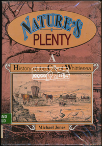 Eltham District Historical Society Inc
Book, Michael Jones, Nature's plenty : a history of the City of Whittlesea, 1992
This book explores Whittlesea's history from early 1830's to 1991. Environment of the Aboriginal people about the the time of European settlement. Possible use of a 'swamp management system' now buried under Yan Yean reservoir. Smallpox epidemics among Aboriginal people prior to settlement - probably from the activity of nearby European sealers. Estimations of Aboriginal populations. Scattered references throughout. Subjects Health - Infectious diseases - Smallpox. Settlement and contacts - Colonisation - 1788-1850. Settlement and contacts - Colonisation - 1851- Environment - Land management. Demography. Woiwurrung / Wurundjeri / Woiwurung people (S36) (Vic SJ55-05) Yan Yean (Vic SJ55-05) Eden Park (Vic SJ55-05) Whittlesea (Vic SJ55-05) Diamond Creek (Vic SJ55-05) Kingslake (Vic SJ55-05) Whittlesea (Vic.) -- History.xvi, 319 p., [16] p. of plates : ill. (some col.), maps (some col.), ports. ; 28 cm. the plenty, farming, settlement, gold rush, plenty river, donnybrook, germantown, separation, thomastown, whittlesea, epping, woodstock, city of whittlesea, railway, yan yean, roll of honour -
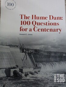 Wodonga & District Historical Society Inc
Book - The Hume Dam: 100 Questions for a Centenary, Howard C Jones, 2019
A booklet describing the history of the Hume Dam in question-and-answer format, illustrated by photographs from the Albury City Collection and other sources. This booklet was produced to accompany the exhibition "Turning the sod: building the Hume Dam", on display at Lavington Library from 21 December 2019 -1 March 2020."non-fictionA booklet describing the history of the Hume Dam in question-and-answer format, illustrated by photographs from the Albury City Collection and other sources. This booklet was produced to accompany the exhibition "Turning the sod: building the Hume Dam", on display at Lavington Library from 21 December 2019 -1 March 2020." hume dam, dams -- new south wales, hume dam history, dams -- new south wales -- design and construction -
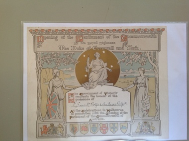 Warrnambool and District Historical Society Inc.
Certificate - Invitation to the opening of the Parliament of the Commonwealth of Australia, 1900
This certificate is an invitation to the opening of the first Parliament of Australia on January 1st 1901 in Melbourne. On this date the six Australian self-governing colonies were federated to become the six states of Australia. The designers of the certificate were Norman Lindsay and John Longstaff. This particular invitation was sent to George Rolfe and his wife and two of his stepdaughters, Annie and Florence. George Rolfe (1836-1919), a tea merchant from Melbourne, began buying blocks of land near the mouth of the Hopkins River in Warrnambool in the 1870s. By the early 1880s Rolfe owned 50 acres in the town, including farming properties and used the buildings near the mouth of the Hopkins as holiday accommodation. He called his property Lyndoch which he improved with the addition of stables, chaff and bone sheds, jetty, boathouse, reservoir, water well and windmill and extensive gardens and he spent most of his later life in this Warrnambool area. Lyndoch today is the site of an aged care facility. This certificate is of considerable importance for two reasons: 1. It is an important memento of a signal event in Australia’s history - the Federation of the States in 1901. 2. The certificate was an invitation to the family of a prominent Warrnambool person – George Rolfe of Lyndoch.This is a piece of thick paper with illustrations and decorations in brown, red, blue, yellow and green tonings. The lettering is in white with coloured capital letters. The images include the shields of the six Australian States, the Coat of Arms of Britain and Australia, outlines of two trees (gum tree and oak tree) and three symbolic female figures representing Justice, Britannia and Australia. The top border decoration represents the waratah flower. The names of the invitees on this certificate have been handwritten in black ink. ‘Opening of the Parliament of the Commonwealth by His Royal Highness The Duke of Cornwall and York’ ‘Mr G and Mrs Rolfe and the Misses Rolfe (2)’ george rolfe of lyndoch, federation of australia, history of warrnambool, george rolfe, opening of first parliament of australia -
 Warrnambool and District Historical Society Inc.
Certificate - Open Commonwealth Parliament, 1901
This is an invitation to George and Annie Rolfe of Lyndoch, Warrnambool, to attend the opening of the first Australian Parliament in Melbourne in May 1901. A smaller invitation card was first sent to the recipients and this larger invitation was sent after the event for the recipients to keep as a souvenir. The six Australian colonies became six Australian States in the newly-formed Commonwealth of Australia in January 1901. George Rolfe (1836-1919), a tea merchant from Melbourne, began buying blocks of land in Warrnambool near the mouth of the Hopkins River in the 1870s. By the early 1880s Rolfe owned 50 acres of land in the town and other nearby pastoral properties. He used the existing building on the land near the mouth of the Hopkins River as holiday accommodation, calling the property Lyndoch and adding stables, bone and chaff sheds, jetty, boathouse, reservoir and windmill and an extensive garden. George Rolfe spent most of his later life at Lyndoch. Today the area is the site of an aged care facility. This certificate is of considerable importance for two reasons: 1. It is an important memento of a signal event in Australia’s history – the Federation of the States in 1901. 2. The certificate was an invitation to George Rolfe of Lyndoch and his wife. Rolfe was a prominent Warrnambool person at that time. This is a piece of cardboard containing an illustration of a young queen in battle dress and on horseback bowing to an image of Britannia. The queen is about to be crowned. There are several lady attendants in the background and two large columns depicted on the sides of the illustration with shields and banners. An extract from Kipling’s poem, The Young Queen, is printed at the bottom of the card. The invitation is coloured in brown, yellow, white and orange tonings. The name of the recipient of the card is handwritten in black ink. The card is slightly scuffed and marked. The card is an invitation to Mr and Mrs Rolfe to attend the Opening of the First Australian Parliament in Melbourne in May 1901. ‘Mr & Mrs G. Rolfe’ federation in australia, george rolfe and family, history of warrnambool, lyndoch warrnambool -
 Stawell Historical Society Inc
Photograph, Mick Walsh, Mick Walsh Stawell Studio Colour Negatives, 1975 to 1986
Negatives from Stawell Photographer. Discarded from Penna Print Ararat. Son contacted and gave approval for Stawell Historical Society to keep them. Only those of a non personal nature scanned. W Pianta Baby Megan Cooper & Rickard Ararat Trots Janet Evans John Shalders 40th Val Wortley 80th Birthday Great Western Cup 1984 Dianne Freeberg & David Wortley Caffrey Family Stawell Motel Dunn Bros New Reservoir Aug 1983 McCanns Val & Max Kennedy & Family Bigmore Family Coopers Cars Walters Wedding Bauer Girls Watchom Leigh McClure Coopers Car Middleton Reunion Carol Cunningham & Rodney Clarke Sue Dunmore Sisters RSL Baby Show 1983 Della Bessingham 4-11-83 Stawell Show 1983 Chas Mangle Cousins Grave Delzotta Car Whelan Pigeons Sharon Hustler & Cliff Naeff Colour negatives of families, weddings and other. Nineteen Lever Arch Folders Mick Walsh 52 Patrick Street Stawellphotography -
 Bendigo Historical Society Inc.
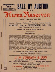
Document - IAN DYETT COLLECTION: AUCTION CATALOGUE - HUME RESERVOIR
Pale beige auction catalogue with red and dark blue printing for a sale held from the 31st August to 5th September 1936 at the Hume Reservoir, Albury, (New South Wales Side) By Order of Department of Works and Local Government, N. S. W. For sale was Contractors', Mining and Engineers' Machinery, Plant and Equipment, Stores, Locomotives, Tools, Petrol and Steam Engines, Tanks, Scrap, Building Materials, Heavy Bridge Timber, Buildings, and Workmen's Five-roomed Houses, etc. J. H. Curnow & Son were the auctioneers. Black and white photos include Lots 2065 and 2622 Kelly & Lewis Engine and Condensing Plant with G.E.C. Dynamo, Generating 300 K.W.; Lot 2018 Locomotive; Lots 2617 and 2618 Steam Road Rollers; Lot 2069 Administrative Offices; and Lot 93 Locomotives (Victorian Side).business, auctioneers, j h curnow & son pty ltd, ian dyett collection - auction catalogue - hume reservoir, department of works and local government nsw, j h curnow & son, j l jamieson & co, j b garnsey, a t jones, bolton bros pty ltd -
 Kew Historical Society Inc
Photograph, J F C Farquhar, Dight's Falls, 1891
At the beginning of the 1890s, the Kew businessman and Town Councillor, Henry Kellett, commissioned J.F.C. Farquhar to photograph scenes of Kew. These scenes included panoramas as well as pastoral scenes. The resulting set of twelve photographs was assembled in an album, Kew Where We Live, from which customers could select images for purchase.The preamble to the album describes that the photographs used the ‘argentic bromide’ process, now more commonly known as the gelatine silver process. This form of dry plate photography allowed for the negatives to be kept for weeks before processing, hence its value in landscape photography. The resulting images were considered to be finely grained and everlasting. Evidence of the success of Henry Kellett’s venture can be seen today, in that some of the photographs are held in national collections.It is believed that the Kew Historical Society’s copy of the Kellett album is unique and that the photographs in the book were the first copies taken from the original plates. It is the first and most important series of images produced about Kew. The individual images have proved essential in identifying buildings and places of heritage value in the district.Dight’s Falls in Studley Park is an artificial weir built on a natural rock bar across the Yarra. The weir was built in the 1840s to provide water to the ‘Ceres’ flour mill, one of the earliest industrial sites in Melbourne. The falls were later to be named after the owner of this mill. In 1888, William Guilfoyle, Director of the Melbourne Botanical Gardens had called for fresh water to be piped from above the weir to the Botanical Gardens, using a pumping station on the Kew side of the Falls, a holding reservoir in Walmer Street and a series of pipes from there to the Gardens. This system was opened in May 1891. Farquhar’s photograph of the man-made weir obscures the industrial activity on both sides of the Falls and focusses solely on the river and the surrounding natural vegetation. The photograph probably predates the disastrous flooding of the Yarra River in July 1891, the greatest to have occurred in the Colony since the foundation of Melbourne.Dight's Fallskew illustrated, kew where we live, photographic books, henry kellett, yarra river -
 Melbourne Tram Museum
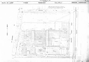
Drawing, Melbourne & Metropolitan Tramways Board (MMTB), "Preston Workshops", c1938
Set of nine photocopied plans or drawings on A3 sheets of the "Preston Workshops" - c1939 .1 - P8491 - Plan of land showing layout and associated drawings including Reservoir railway line - 19-4-1939. .2 - P8492 - Plan of Timber stacks and Hall - 3-2-1939 .3 - P8493 - Plan of Offices and location of sub-station - 13-12-1938 .4 - P8494 - Plan of Store including Oil store - c1939. .5 - P8495 - Plan of Paint Shop and relationship to timber stack - 1-3-1939 .6 - P8496 - Plan of Car building and Repairs shop - 6-12-1938 .7 - P8497 - Plan of machine shop - 10-12-1938 .8 - P8500 - Plan of Blacksmiths shop - 1-12-1938 .9 - P8590 - Plan of Substation - 1-12-1938trams, tramways, drawings, depots, property, preston workshops, workshops, substation -
 Wodonga & District Historical Society Inc
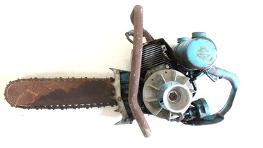
Tool - L-30 Chain saw, Lombard, 1962 - 1964
This chainsaw was one of the earliest models sold in Australia. It was manufactured by the Lombard company which was established in 1894 when Nathaniel Lombard developed the first practical water wheel governor in Roxbury, Massachusetts, USA. In 1904, the company moved to Ashland, Massachusetts. During the first World War, Lombard Governor produced hydraulic lathes for the manufacture of artillery shells At the conclusion of the war, Lombard expanded into the areas of chain saws and plastic molding injection machines. This model, the L-30 was only produced for 2 years from 1962 - 1964, primarily due to safety concerns and the fact that it did not have any way to sharpen or tighten the chain. This chainsaw was sold by Mann of Wodonga and donated to the Wodonga and District Historical society by David Mann, owner and manager of Mann Wodonga.This item is significant as it was produced for a limited time. It was also sold by a prominent Wodonga business.A single operator chain saw from Lombard, Ashland, Massachusetts, USA. The chainsaw was relatively lightweight but had no safety features such as a chain brake. It was made primarily of sand cast magnesium. The main cylinder was constructed of aluminium with a cast iron sleeve. It had a manual oil pump, the crankshaft operated on ball bearings and it had a maximum rpm of 4,500. See the Model profile in the accompanying Media item for details.On side of fuel tank: "ONE HALF PINT/SAE-30 OIL/ FOR EACH/ GALLON GASOLINE/ MIX WELL IN SEPARATE CONTAINER/BEFORE FILLING" On opposite side: "STARTING INSTRUCTIONS 1: FILL FUEL TANK WITH PROPER FUEL MIXTURE ( AS NOTED ON TANK) 2. FILL OIL RESERVOIR WITH #30 MOTOR OIL 3. CLOSE CHOKE, MOVE LEVER BACK TOWARDS AIR FILTER 4. HOLD THROTTLE WIDE OPEN 5. PULL STARTER HANDLE SLOWLY UNTIL STARTER ENGAGES, THEN GIVE IT A SHARP YANK 6. AS ENGINE WARMS UP, EASE CHOKE LEVER TO OPEN POSITION"hand tools, vintage chainsaws, david mann, mann wodonga -
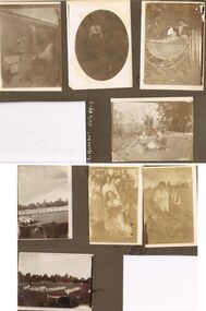 Bendigo Historical Society Inc.
Photograph - HILDA HILL COLLECTION: BLACK AND WHITE PHOTOS
Hilda Hill Collection. Combination Sepia & Black & White Photos Double Sided Card Total of 8 depicting family life towards the end of the First World War in 1918 up until July 1924. A comparison exists between life at 'The Ranch' ? In Eppalock in 1918 versus life at 'The Ranch' in 1924. lady standing at the front of the house with left arm raised to shade her eyes dressed in a dark coloured dress, light coloured cover on chair in background at 'the Ranch' June 1918. Oval black and white photo of Doreen at Durvol, dressed in black skirt and white shirt with black school? Tie June 1918. Proud parents with baby sitting in pram, both p[parents are wearing dark coloured hats dark clothing and white shirts, pram is boat style body with large rear wheels and smaller front wheels. White picket fence in background, May 1918. Also on this page is a reference to 'The Ranch' July 1924 in white, but no photo. Claire and Doreen sitting on lawn area, small garden to left, row of decorative plants in semi circle, dead tree centre background and other trees to left and right background, S.H.L.C. 24 Sept 1918. Boys' Flag Drill - repatriation Upper Reserve 19 October 1918. Group of people, all but one females, all in white at No. 7 reservoir happy 9 January 1919. Al and Marie sitting, Al in all white and hatless, Marie in white blouse and black waistcoat with black tie, foreground shows large rocks, background has trees in distance, No.7 reservoir 9 January 1919. Childrens folk dance at Upper Reserve, All children dressed in white, large round hat in foreground, and suited man in hat walking past 19 October 10918.Hilda Hill Personal Collectionaustralia, history, post war life -
Federation University Historical Collection
Book, The Melbourne Technical College Hydraulic Engineering
... reservoirs ...Two volumes of course notes for the course of Hydraulic Engineering at the Melbourne Technical Collegehydraulic engineering, melbourne technical college, rmit, rex hollioake, leakage, aquaducts, dams, spillways, ground water, pumping, curvss, pipes, reservoirs, tanks, weir, channel, water supply, sewerage, sewers, sewerage treatment, drainage