Showing 3447 items
matching road bridges
-
 Warrnambool and District Historical Society Inc.
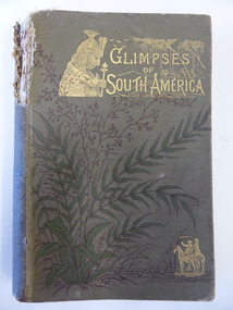
Book, Glimpses of South America, 1882
... on the Merri River (near Cassady’s Bridge, Caramut Road today... Cassady’s Bridge, Caramut Road today). This property was established ...This book was given as a Sunday School prize to James Cassady. The donor was William Wines. The Wines families were pioneers in the Woodford district. James Cassady was the son of William and Elizabeth Cassady and the family lived at Boughton on the Merri River (near Cassady’s Bridge, Caramut Road today). This property was established about 1845. Charley and Joe, whose names have also been written in the book, were James’ brothers. This book is of interest because it belonged to James Cassady, the son of pioneer settlers in Cassadys’ Bridge/Woodford area. This is a hard cover book of 220 pages with 32 extra pages at the back of the book giving information on other books produced by the same publisher. The cover is grey-green with gold lettering, green and black floral decorations and gold images of two men on horseback and a South American Indian chief. The spine is torn away at the top and the cover and pages are stained and crumpled. There are many black and white illustrations throughout the text, with the frontispiece protected by a piece of tissue. The inscriptions are handwritten in black ink and pencil.‘Woodford Sunday School presented to James Cassidy (sic) by his well-wisher William Wines’ (this is re-written underneath in pencil with the correct spelling of ‘Cassady’) ‘Chaley cassady, boughton, merri river (sic) “Joe’ james cassady,, boughton, william wines, woodford sunday school, history of warrnambool -
 Ballarat Tramway Museum
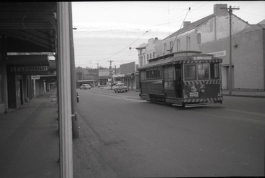
Photograph - B&W print of donated negative, Ron E. Fluck, 23/06/1962 12:00:00 AM
... . and the Caltex service station in the background on Main Road and Bridge.... and the Caltex service station in the background on Main Road and Bridge ...Black and white print of a donated negative. Print made 8/1998. Photo of SEC tram no. 31 in Main St, Ballarat East, with destination of "Gardens via Drummond St." Tram has been fitted with dash canopy lighting, but not the large white strip under the lighting. Has small triangles on the panels. Also has a small ad for White Horse whisky. Shows buildings on either side of Main St. and the Caltex service station in the background on Main Road and Bridge St. Photo taken 23-6-1962. Copy made Oct. 2001 for the "gold, Gold GOLD" temporary exhibition - colour laser print onto card, with Velcro dots on rear. Stored in box D1 (Display Box) 02/2003. High Res scan of negative added 17/1/2019.tramways, trams, main st, 31, ballarat, tram 31 -
 Nillumbik Shire Council
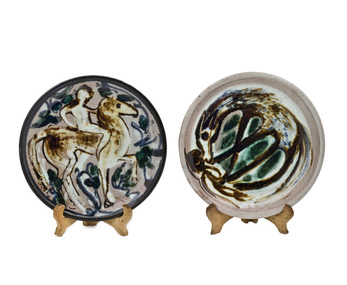
Ceramic (plates): Alma SHANAHAN (b.1924 - d.2015 Melb.), Alma Shanahan, Horse Power - The Flip Side, c.1965
... at the top of the hill, 135 Barreenong Road, Cottles Bridge. The c... Barreenong Road, Cottles Bridge. The c.1953 house is historically ...Alma Shanahan (1924-2015) was a Victorian potter who came to live at Clifton Pugh's Dunmoochin art colony at Cottlesbridge, on Melbourne's outskirts in 1953. Unable to join the co-operative proper, as she was a potter, not a painter, she built her house at the top of the hill, 135 Barreenong Road, Cottles Bridge. The c.1953 house is historically, aesthetically and architecturally significant because it is a good example of the design and ethos of mud brick dwellings synonymous with Eltham and features the extensive use of recycled materials, which was characteristic of the 'Eltham style' of architecture. Like the others in the artist community, Alma Shanahan built her own residence in stages out of local materials. Shanahan was later joined by neighbours and Dunmoochin potters Peter and Helen Laycock. She trained for a term with Peter Laycock but was otherwise self-taught, basing her practice on the teachings of Bernard Leach. After Pugh's death in 1991 she became the longest standing Dunmoochin resident. Her works are incised with her full name. Alma Shanahan was a part of the Dunmoochin Artist's community whose (other) members (Kevin Nolan, John Howley, John Olsen, Mirka Mora, Peter Laycock, Helen Laycock, Peter Wiseman and Chris Wiseman) made an important contribution to Victoria's cultural history. From the mid 1950s Pugh persuaded a number of other painters, as well as potters and other artists, to come and live at Dunmoochin and they formed one of Victoria's most important artist communities. She started potting around 1961 (aged 37). "Horse Power" was made using Chullora clay, which indicates it was made during her first seven years of production. Horse Power is about man's search for "energy" and how the "energy" can turn around. Made from Chullora (Sydney) clay. Glazed stoneware plates (x2) with brush decorations resting on hand made ceramic stands. Plate one: 2006.64.1VA (Horse Power + stand) shows a figure on horse back with blue foliage in background. Plate two: 2006.64.2VA (Flip Side + stand) shows a horse with figure under it's hooves. Hand painted signature in brown/black on back of both plates; "Alma Shanahan"shanahan, stoneware, glaze, plates, horse, dunmoochin -
 Bendigo Historical Society Inc.
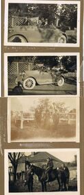
Photograph - HILDA HILL COLLECTION: BLACK AND WHITE PHOTOS, 1923
... girls, standing next to a road bridge with wooden railings, two..., standing next to a road bridge with wooden railings, two males ...Series of Black & White Photos Total 4 depicting post war life for the Hill Family & Friends. The Hayes' Family Buick, 4 occupants and two men standing on offside of vehicle, two men in front seat are wearing dark suits and hats, two ladies in rear seat wear dark clothing, one has a hat, man standing beside the car in dark suit white shirt and black tie, other man nearer the back is wearing a grey suit, wooden cross in background near rear of vehicle, trellis fence left background, short white picket fence right background, 'Durvol'. This photo has two men in the front seat, both wearing grey suits white shirts and black ties, driver only wears a hat, in the rear seat are two ladies wearing dark clothing, one wears a hat, and a male wearing a dark suit white shirt and dark tie, Note anti kick guards below each door. At Hanging Rock family group, three gentlemen one lady and two young girls, standing next to a road bridge with wooden railings, two males are dressed in dark suits white shirts and dark ties, one wears a hat, man sitting on bridge rail wears a grey suit white shirt and dark tie, the two young girls are wearing light coloured clothing. Martin, Jack, Tom & Dolly the Horse, three boys wearing dark clothing, two boys are wearing white shirts and dark ties, Dolly is dark coloured, background shows gable roofed house with one chimney, end of veranda , large tree left background, wooden paling fence, 'Durvol' property Kyneton 1923.Hilda Hill Pesdonal Collectionaustralia, history, post war life -
 Melbourne Tram Museum
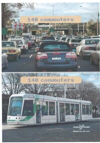
Poster, Yarra Trams, "140 Commuters", c2003
... , titled "140 Commuters", showing a photograph of a crowded road... of a crowded road with a rail bridge in the background (Hoddle St ...Poster - full colour on off white paper, A4 single sided, titled "140 Commuters", showing a photograph of a crowded road with a rail bridge in the background (Hoddle St Richmond) and C 3035 with the destination of St Kilda Beach on a route 96. Has the Yarra Trams Melbourne all over logo. 2 copies held. See Reg Item 2515.3 for a different version.trams, tramways, yarra trams, hoddle st, richmond, route 96, st kilda beach, c class, tram 3035 -
 Orbost & District Historical Society
black and white photograph, Howard D. Bulmer, first half 20th century
... , and the bridge was only used by road traffic. ..., and the bridge was only used by road traffic. This is a pictorial record ...A new bridge over the Snowy River at Orbost was opened for traffic on June 20th 1922. It was intended as a road and rail bridge, and was again partly washed away by flood waters in 1934. After the end of the first World War the Victorian Railways considered an extension of the railhead across the river at Orbost, and in 1922 a new timber and steel girder structure, a joint Country Roads Board — Victorian Railways venture, was built and completed at a cost of £41,000 (the steel girders came from the Flinders Street viaduct reconstruction). Subsequently it was decided decided not to take the railway across the river, and the bridge was only used by road traffic. This is a pictorial record of an early bridge over the Snowy River at Orbost.A black / white postcard photograph of a bridge across a shallow river with men on horseback underneath.snowy-river-bridge -
 Ballarat Tramway Museum
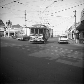
Photograph - Set of four black and white negatives of Ballarat trams, Warren Doubleday, 20-4-1968
... with Caltex Service Station in the background. Tram leaving Main Road... trams tramways Sturt Street tram 17 Main Road Bridge Street tram ...Photos 25-4-69, of: .1 - Ballarat 17 at Stones Corner with Caltex Service Station in the background. Tram leaving Main Road before joining Bridge St. .2 - No. 28 running from Bridge Street into Sturt Street with a "Trotting at Bray Raceway Tonight" Auxillary board. Tram has the destination of Gardens via Sturt St West. In the background are the Big W and the Dickins Store. .3 - Tram 43 on "0" road at the SEC Ballarat Depot. .4 - Tram 13 at the Gardens Loop in Wendouree Parade. Tram has an ANA Hospital and Medical Benefits (Australian Natives Association) Advertising Board.Yields information about the operation of the Ballarat tramway system that was operated by the State Electricity Commission of Victoria.Set of four black and white negatives of Ballarat Tramways, 120 size. ballarat, trams, tramways, sturt street, tram 17, main road, bridge street, tram 28, bray raceway, dickins, big w, tram 13, ana health, wendouree parade, gardens loop, depot, tram 43, stones corner, caltex -
 Bendigo Historical Society Inc.
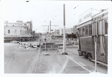
Photograph - BASIL MILLER COLLECTION: TRAMWAY RECONSTRUCTION
... Two black and white photographs of bridge/road works being... of bridge/road works being undertaken next the the Alexandra ...Two black and white photographs of bridge/road works being undertaken next the the Alexandra Fountain. Each photograph has been taken from opposite sides of the tram shown in the photograph. Both views are looking up Mitchell St. 'Ezywalkin' signs above shop on left corner. Photograph 'b' has large white area on left side. Reverse: 'a' 'C922' stamped in black , bottom edge. 'b' 'C922' stamped in black bottom edge. Both photographs have a 'Kodak paper' printed in grey at angle across back..person, individual, basil miller -
 Melbourne Tram Museum
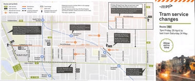
Pamphlet, Public Transport Victoria (PTV), Tram Service Changes, 2022
... Road over rail line bridge - 29-4-2022 to 14-5-2022 .2 - All... Yarra Trams PTV Bridges trams tramways route 72 malvern road ...Pamphlet provided at tram stops giving details of the works and bus services for: .1 - route 72 track reconstruction between Chapel St and Orrong Road, in Malvern Road including the Orrong Road over rail line bridge - 29-4-2022 to 14-5-2022 .2 - All Collins and William St routes for the installation of a super stop in William St at Collins St - - 2-2-2022 to 6-2-2022Shows the methods that Yarra Trams and Public Transport Victoria customers are advised of changes due to track replacement works..1 - Pamphlet - DL, five fold DL - Tram service changes - route 72 - 29-4-2022 to 14-5-2022 .2 - Pamphlet - DL, four fold DL - changes in Collins and William Streets - 2-2-2022 to 6-2-2022tram works, track work, yarra trams, ptv, bridges, trams, tramways, route 72, malvern road, orrong road, super stops, collins st, william st -
 Melbourne Tram Museum
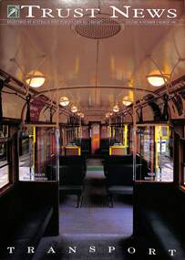
Magazine, National Trust, "Trust News - Vol 18 No 8", March 1990
... Power or Engine house on the corner of Bridge Road and Hoddle St... or Engine house on the corner of Bridge Road and Hoddle St. Notes ...Published by the National Trust Victoria features a front cover photo of the interior of an SW5 class car by Brian Gilkes. Has an article by Frank Strahan on Melbourne W class trams and puts a case for their classification. Includes a photo of the Great Strike lineup of trams in Bourke St, An article by Celestina Sagazio on Melbourne's cable tram system looks at its history, remaining buildings, and Alf Twentyman's cable cars. Concludes with a note on the impending demolition of the Richmond Power or Engine house on the corner of Bridge Road and Hoddle St. Notes the moves to retain it and includes a photo of the building by Brian Gilkes. There is also an article on the Port Melbourne railway line, its heritage, and demolition.Yields information about the National Trust's proposals for the W class trams, cable trams and the Port Melbourne rail line.Magazine - 32 pages - part colour centre stapled.national trust, cable trams, w class trams, tramways, richmond, engine houses, port melbourne railway -
 Kew Historical Society Inc
Plan - Subdivision Plan, Oswinia Estate, East Kew, c.1925
... the proposed bridge over the Yarra at Burke Road. The bridge... the proposed bridge over the Yarra at Burke Road. The bridge ...Prue Sanderson, in her groundbreaking ‘City of Kew Urban Conservation Study : Volume 2 - Development History’ (1988), summarised the periods of urban development and subdivisions of land in Kew. The periods that she identified included 1845-1880, 1880-1893, 1893-1921, 1921-1933, 1933-1943, and Post-War Development. These periods were selected as they represented periods of rapid growth or decline in urban development. An obvious starting point for Sanderson’s groupings involved population growth and the associated economic cycles. These cycles also highlighted urban expansion onto land that was predominantly rural, although in other cases it represented the decline and breakup of large estates. A number of the plans in the Kew Historical Society’s collection can also be found in other collections, such as those of the State Library of Victoria and the Boroondara Library Service. A number are however unique to the collection.Subdivision plans are historically important documents used as evidence of the growth of suburbs in Australia. They frequently provide information about when the land was sold on which a built structure was subsequently constructed as well as evidence relating to surveyors and real estate and financial agents. The numerous subdivision plans in the Kew Historical Society's collection represent working documents, ranging from the initial sketches made in planning a subdivision to printed plans on which auctioneers or agents listed the prices for which individual lots were sold. In a number of cases, the reverse of a subdivision plan in the collection includes a photograph of a house that was also for sale by the agent. These photographs provide significant heritage information relating house design and decoration, fencing and household gardens.The ‘Oswinia Estate’ subdivision in East Kew was planned and auctioned in the first half of the 1920s. 169 allotments were created in the triangular section of land bordered by High Street, Burke Road and the Government Boulevard (later Kilby Road). The only piece of land excluded was that where the previous Kew Pound had been located at the east tip of the triangle. Allotments were created fronting Glass, High, Namur, Oswin Streets, Irymple Avenue, and the Government Boulevard. The name for the Estate was derived from Oswin’s farm, which had been one of the largest landholdings in East Kew. The selling agents annotated the plan in our collection with crosses indicating those lots that had been sold. The inset locality plan is particularly interesting as it shows the route and stations of the Outer Circle Railway. When the subdivision plan was created, it included the proposed bridge over the Yarra at Burke Road. The bridge was to be officially opened in 1926.subdivision plans - east kew, oswinia estate, high street, glass street, namur street, government boulevard - kilby road, irymple street, oswin street -
 Orbost & District Historical Society
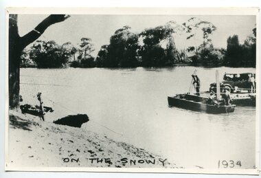
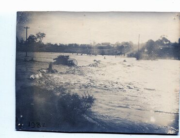
black and white photograph, 1934
... was reinstated on a temporary basis following damage to the bridge... was reinstated on a temporary basis following damage to the bridge ...This photograph shows vehicles and people being ferried across the Snowy River during the 1934 flood. The Orbost punt was reinstated on a temporary basis following damage to the bridge. Damage estimated at £500,000 was caused by the 1934 floods in the Orbost district. This 1934 flood was devastating, destroying a section of the 1922 Orbost bridge, wrecking fences, bridges and roads, dumping silt and debris on the rich river flats and drowning cattle. The centre span of the Orbost Bridge was washed away.This is a pictorial record of the effects of the 1934 floods in the Orbost district.A large black / white photograph of a punt with a motor vehicle and people making their way across a river.on front - "On the Snowy 1934"snowy-river-orbost flood-1934 river-transport-punt -
 Warrnambool and District Historical Society Inc.
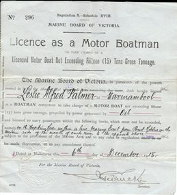
Document, Licence Motor boatman, 1918
... , making it more convenient than going by road to cross the bridge... by road to cross the bridge. It was, and still is, a common ...This is a licence issued to Leslie Palmer in 1918. It gives him authority to operate a motor boat across the banks of the Hopkins River near the mouth and to carry passengers. As there is a bridge at the mouth of the river it is assumed that this motor boat was used to go across the river from a private house, making it more convenient than going by road to cross the bridge. It was, and still is, a common practice to use boats to cross the river from private homes built along the banks of the Hopkins River.This is a significant item as it is an original certificate and is interesting because the licence was a restricted one, for use only in crossing the Hopkins River. This is a paper licence issued by the Marine Board of Victoria in 1918. The certificate has printed material and entries written in black ink. It has the seal of the Marine Board and the signature of the SecretaryWritten material: ‘Leslie Alfred Palmer of Warrnambool, oil, on the Hopkins River within a line bearing east from Point Ritchie on the western side of the mouth of such river to the opposite shore, 6th December 1918’ motor boat licence 1918, warrnambool, leslie palmer, hopkins river -
 Kew Historical Society Inc
Archive (Sub-series) - Subject File, Kew Historical Society, Gardens (Kew), 1979
... in c. 1845 near what is now the Burke Road Bridge (she notes... the Burke Road Bridge (she notes that a search for the trees ...Various partiesReference, Research, InformationSecondary Values (KHS Imposed Order)Correspondence and newspaper articles/clippings relating to historic gardens in Kew. The oldest item is a letter from the National Trust Victoria announcing their two-year garden study and seeking information on gardens in Kew. Mavis Rolley, Secretary of the Society, made handwritten notes in response, which are kept in the file. She refers to: the pear trees planted by William Oswin in c. 1845 near what is now the Burke Road Bridge (she notes that a search for the trees at the time of the construction of the Eastern Freeway was unsuccessful), a camellia planted by the Dannocks near the corner of Derby and High Street, a c.1876 pine tree in Field Place, Henty Court, an 1875 Moreton Bay fig at Tarring, Ruyton, a Moreton Bay fig at Roxeth, Trinity Grammar, an 1840s oak tree and a 120-year old olive tree at Fairholme, Barry Street, 1870 pine trees at D’Estaville, Barry Street, trees at Turinville, Barnard Grove, dating to 1846, pine trees dating from 1845-6 on the Willsmere Farm, red gums in Victoria Park, pine trees in the Cemetery dating from the 1860s, trees in the Alexandra Gardens and at Kew Primary School, palm trees at La Verna, Sackville Street dating from the 1890s, the trees and gardens at Ross House (Charleville), and the trees at Merridale, Sackville Street which date from the 1880s, a magnolia at Lalla Rookh. These dates are probably highly contestable. Other handwritten notes from 1979 about significant gardens included: 5 Molesworth Street, Red Bluff - Redmond Street (garden now destroyed), Campion House, Studley Park Road, Raheen, Studley Park Road, Ross House, Cotham Road (Charleville), 7 Adeney Avenue, 20-21 Belmont Avenue, 52 Mary Street, an Edna Walling garden on the corner of Argyle Road and Victor Avenue, Merridale, Sackville Street, Roseneath, and Reno, St John’s Parade.gardens - private - kew (vic), garden design - kew (vic), kew horticultural societygardens - private - kew (vic), garden design - kew (vic), kew horticultural society -
 Melbourne Tram Museum
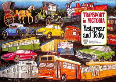
Book, Ministry of Transport, "Transport in Victoria - Yesteryear and Today", 1980
... , transport interchanges, West Gate Bridge, Roads and Freeways..., the underground loop, transport interchanges, West Gate Bridge, Roads ...Pamphlet or Book - 20 pages, full colour printed on gloss paper, centre stapled titled "Transport in Victoria - Yesteryear and Today", published by the Ministry of Transport giving an outline of Victoria's transport history from 1834. Provides a short history of the state transport system, railways, roads, trams, Metropolitan planning, the Bland report, social changes, the underground loop, transport interchanges, West Gate Bridge, Roads and Freeways, transport inquiry of 1980 and environmental changes resulting from motor cars. 2nd copy added 14-5-2016 from the estate of Charles Craig.trams, tramways, minister for transport, railways, trb, crb, murla, planning, history -
 Melbourne Tram Museum
Document - Research Notes, H. S. McComb, "Extracts from the Minutes of the Prahran and Malvern Tramways Trust which was constituted under Act of Parliament No. 21030 in 1907", 1940's
... ., Dandenong Road lines, railway bridges, extension of High St to St...., Dandenong Road lines, railway bridges, extension of High St to St ...Original and carbon copy of "Extracts from the Minutes of the Prahran and Malvern Tramways Trust which was constituted under Act of Parliament No. 21030 in 1907", 10 foolscap sheets. Includes depot purchase, regrading of High St, extension to Burke Road, relocation of water mains, surveys, starting of construction, tenders for track and buildings, opening, extension, F. A. McCarty & Co., Dandenong Road lines, railway bridges, extension of High St to St Kilda Road, MMBW, finances. Items 2041 to 2052 within box 72.3 in a brown folder marked "PMTT" in red pencil.trams, tramways, pmtt, malvern, routes, track, surveys, malvern rd, tenders, construction, opening, dandenong rd, mmbw, finances -
 Eltham District Historical Society Inc
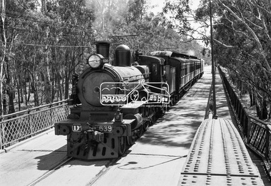
Photograph, VR Commissioner's Special train, steam locomotive D3-639 crossing the Echuca-Moama Road Rail Bridge over the Murray River from Moama, NSW to Echuca, Victoria, 1962
... crossing the Echuca-Moama Road Rail Bridge over the Murray River...Echuca-Moama Road Rail Bridge... crossing the Echuca-Moama Road Rail Bridge over the Murray River... crossing the Echuca-Moama Road Rail Bridge over the Murray River ...VR Commissioner's Special train, steam locomotive D3-639 crossing the Echuca-Moama Road Rail Bridge over the Murray River from Moama, NSW to Echuca, Victoria. Commissioner Edgar Henry Brownbill on footplate, 1962. Commissioner Edgar Henry Brownbill was in office 1957 to 1967. George Coop advises - "The train on the Eltham/Moama bridge is actually the Commissioner’s Special on one of its inspection tours of the VR rail system. This was a very grand special train with accommodation for the Commissioner and staff in carriages also used once for the Royal Train and other State purposes. You can just see the Commissioner of the day, dressed in his suit and wearing engine drivers gloves, standing in the loco cab doorway. A good ‘hands on’ impression is created amongst local staff if can be seen that the boss is no ‘desk jockjey’. The observation car on the back was originally made for the ’Spirit of Progress’. I climbed up onto the bridge iron plate work to get this view. It was safe enough as the cantilevered pedestrian walkway was still on the east side at the time." "I was resident in Echuca from Jan. ’59 to approx. May ’64. At that time the single Echuca/Moama bridge was a combined road/rail bridge. The rail gauge was 5’3” and still is, I believe, on the new bridge that sits just upstream of the old one. This rail line into NSW has always been 5’3" gauge because it has no connection with any NSW tracks. The old Echuca/Moama bridge, locally called the ‘Iron Bridge’ has, over years, undergone some structural changes. The two lattice iron hoops arcing over the roadway have been raised and lowered and changed design. Presently a pedestrian walkway is cantilevered off the west (or downstream) side of the bridge. It used to be on the eastern side. Guess changes went in when new rail bridge only was built on the eastern side as well." Image dated as c.1963 based on same image in Port of Echuca collection (possibly frame 32 of film) (print 19.5 x 24.5cm) On reverse in pencil: "Brown card" in black pen: "Commissioners special. F. Brown on Footplate. George C.L. Coop c1963". https://victoriancollections.net.au/items/59d575b921ea6e1278d78042 However based on frame no. 10, date set as 1962Digital TIFF file Scan of 35mm Ilford FP3 black and white negative transparencyd3-639, d3-class steam locomotive, echuca-moama road rail bridge, edgar henry brownbill, george coop collection, murray river, vr commissioner's special train -
 Melbourne Tram Museum
Photograph - Digital Image, Kevin O'Reilly, series of three images of the Hawthorn Bridge over the Yarra, c1930, c1930's
... can be seen. .2 - Looking along Bridge Road to the east... can be seen. .2 - Looking along Bridge Road to the east ...Image from CD (Compact Diskette for use in computers) - see Reg Item 135. A series of three images of the Hawthorn Bridge over the Yarra, c1930, during the era with problems with the bridge. See separate article for more details. Richmond 6, Richmond, Richmond 3 on the CD as original files. .1 - Looking from the south west, at the Hawthorn bridge with the temporary wooden bridge being constructed on the south side. Has the cable tram depot in the photo and part of the Burnley racing course. Temporary track on the north side of the steel bridge and crossings can be seen. .2 - Looking along Bridge Road to the east with Hawthorn Bridge in the middle of the photograph. Shows the industrial and residential areas, Hawthorn Railway Station and part of the Burnley Race course, the cable tram depot building. W class tram in Church St Hawthorn and W class tram crossing the bridge on the north side temporary track. Note the cable tram used as a shelter on the north east corner of the bridge. .3 - Looking south along River St towards Bridge Road, with the Yarra River and Hawthorn Bridge on the left side of the photograph. Shows the industry in the area at the time, wool and skin Merchants, north side of the cable depot, housing and the outlook to the river!trams, tramways, hawthorn, yarra river, burnley, richmond, hawthorn bridge -
 Ringwood and District Historical Society
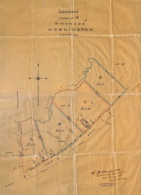
Plan, Subdivision of Crown Lot 19, Ringwood, Victoria - circa 1915
... , later Whitehorse Road, small creek bridge, later Sandy Creek... Road Ringwood North melbourne Subdivision map includes Mullum ...Surveyor's map on wax paperSubdivision map includes Mullum Creek, Government Road to Anderson's Creek, later Warrandyte Road, Government Road to Lillydale, later Whitehorse Road, small creek bridge, later Sandy Creek at Ringwood Lake. Buildings marked include Roman Catholic Church, O.J. Pratt's House and Pratt's butcher shop (photos attached). Map by A.B. Bruford & Co., Licensed Surveyor, 47 Queen Street, Melbourne. -
 Eltham District Historical Society Inc
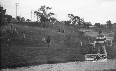
Photograph, ELTHAM ARBOR DAY 1973 - Alistair Knox with school children of the Shire of Eltham, Vic, planting native trees in the Town Park, 10 October 1973, 1973-10-10
... Park Main Road to left and Bridge Street to right - looking... Park Main Road to left and Bridge Street to right - looking ...ELTHAM - ARBOR DAY, 10 Oct 1973. School children of the Shire of Eltham planting trees (previously planned to take place during the visit of Sir Rohan Delacombe to the Shire on 19th September, 1973 but cancelled that day due to inclement weather). REF: 783 SOURCE: Shire of Eltham (Eltham District Historical Society) Eltham Town Park would later be renamed Alistair Knox Park Main Road to left and Bridge Street to right - looking southeastBlack and white photographeltham, arbor day, alistair knox, alistair knox park, eltham town park, main road, bridge street -
 Warrnambool and District Historical Society Inc.
Book, Chambers’s Journal 1874, 1874
... . The property, ‘Woodend’, was near Cassadys Bridge (Caramut Road today..., ‘Woodend’, was near Cassadys Bridge (Caramut Road today). The aunt ...This is a book given to Margaret Davidson in 1875 by her aunt, Mrs J. Davidson. Margaret Milne Davidson (1839-1928) was the eldest child of James and Isabella Davidson and she was born in Kirriemuir, Scotland. She came to the Warrnambool area in 1850. The property, ‘Woodend’, was near Cassadys Bridge (Caramut Road today). The aunt, Mrs J. Davidson would be the wife of John Davidson, the brother of James and a farmer at ‘Rosebank’, Woodford. The portraits of John and James Davidson are on the Warrnambool Pioneer Honour Board. This book is of interest because of its inscription. The book is connected to the Davidson families, prominent in Warrnambool’s pioneer history.This is a hard cover book of 832 pages. The book has a dark green cover with dark green and gold lettering with ornamental gold surrounds. The book has an index, short stories, poems, essays and articles on science and the arts. The book contains monthly journals for 1874 combined in one volume. The cover is stained and blotched. There are several stamps of the Warrnambool & District Historical Society. The inscription on the first page is handwritten in black ink. ‘Margaret M. Davidson, Woodend, from her aunt, Mrs J. Davidson, 30/9/75’.margaret davidson, james and john davidson, history of warrnambool -
 St Kilda Historical Society
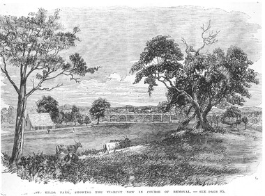
Photograph - Photograph of artwork, St Kilda Park, showing the viaduct now in course of removal, 25/06/1867
... embankments fifteen feet high, crossing over St Kilda and Punt Roads... embankments fifteen feet high, crossing over St Kilda and Punt Roads ...St Kilda Park, now Albert Park Reserve, showing cows, eucalyptus trees, oval and a railway viaduct in background. The viaduct was part of the Windsor to St Kilda loop line which operated between 1857 and 1867. The loop line ran from the St Kilda railway station on a combination of wooden viaducts and earth embankments fifteen feet high, crossing over St Kilda and Punt Roads by way of bridges and then gradually decreasing to a level crossing at Union Street and then on to Windsor station. Black and white photograph of a lithograph published in a book (unidentified)ST KILDA PARK, SHOWING THE VIADUCT NOW IN COURSE OF REMOVAL - SEE PAGE 85st kilda railway station, albert park, windsor to st kilda rail loop -
 Kew Historical Society Inc
Work on paper - Sepia Wash & Ink, G B Richardson, Creek and Old Watering Stage, on the Yarra, East Collingwood, 1854, 1854
... Park Road (Johnston Street) Bridge in 1858 made its continued... Park Road (Johnston Street) Bridge in 1858 made its continued ...Blind Creek was located between the Abbotsford Convent and what is now the Collins Bridge in Studley Park. In an 1858 map of East Collingwood by Clement Hodgkinson, in the State Library of Victoria, one can see how the creek was originally a significant landmark in Collingwood; remaining vacant land until a barrel drain enclosed it. The area was later filled in, surveyed and developed. The position where Blind Creek entered the Yarra was in the immediate vicinity of Hodgson’s Punt, which had linked Kew to the other side of the Yarra from 1839. The Punt was purchased by the Colonial Government in 1852 and was in use until the opening of the Studley Park Road (Johnston Street) Bridge in 1858 made its continued use redundantThe point of view selected by the artist for the watercolour is from the banks of Blind Creek in East Collingwood, looking across the Yarra to the Kew side of the river.Inscribed verso 'Creek and Old Watering stage, on the Yarra East Collingwood 1854 / Trees, stage, &c have long since disappeared / [Artist Signature] / FT 110 / Creek itself now being filled in 1903.gb richardson, blind creek - abbotsford, yarra river - abbotsford (vic) - kew (vic), colonial artists, australian art - 19th century, george bouchier richardson -
 Melbourne Tram Museum
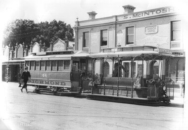
Photograph - Cable trams - Bridge Road Richmond terminus, A G Renwick, 1/1924
... Cable trams - Bridge Road Richmond terminus...Bridge Road... at the Bridge Road Richmond terminus. The S McIntosh's Bridge Hotel... at the Bridge Road Richmond terminus. The S McIntosh's Bridge Hotel ...The photograph shows a cable tram set with trailer 44 at the Bridge Road Richmond terminus. The S McIntosh's Bridge Hotel is in the background, along with four shops including the Oriental Cafe for Tea and Grills. It would appear that the gripman is ready to leave though a male passenger seems to be hurrying forward to catch the tram. The typed caption records that the dummy is No. 12, the photograph is dated Jan. 1924 and notes the slotted depot lead out track in the foreground. Also discusses the ventilator cones on the grip car, following the installation of electric lights. Photo by A G Renwick. Second print, would have been the original view from which the first one has been taken from.Yields information about the Bridge Road Richmond terminus Jan. 1924Black and white photo with a typed caption attached. Second image - a vertical photo with notes on the rear.See second image. In pencil "163" in top right hand corner and "cable, Bridge Rd line"tramcars, tramways, cable trams, richmond, bridge road, tram 44, tram 12 -
 Eltham District Historical Society Inc
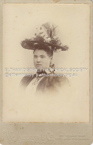
Photograph, W. Mason & Co, Unidentified Shillinglaw Family Female, c.1900
... Photographer W. Mason & Co. operated from 150 Bridge Road... melbourne Photographer W. Mason & Co. operated from 150 Bridge Road ...Photographer W. Mason & Co. operated from 150 Bridge Road, Richmond from c.1893-c.1902 CABINET 1866-1905 The Cabinet photo was introduced in 1866 in answer to a demand for a larger format photograph which could be mounted for a cabinet or on the wall. They were 4.5 inches by 6.5 inches (11.5 x 16.5 cm), more than twice the size of the cdv. They cost about twice as much as a cdv but eventually displaced them. They were not extensively produced until 1880 and had ceased by 1905. Coloured mounts, especially maroon or green, indicate a date between 1880 and 1890. - Frost, Lenore; Dating Family Photos 1850-1920; Valiant Press Pty. Ltd., Berwick, Victoria 1991cabinet photo, marg ball collection, shillinglaw family photo album 3, 1900, female shillinglaw 10, w. mason & co. photographer 150 bridge rd melbourne, unknown, 1893-1902 -
 Eltham District Historical Society Inc
Photograph, Tess Justine (Nillumbik Shire Council), Murray's Bridge over the Diamond Creek, Eltham North, 19 Feb 2022
... by road, with only an old low-level bridge over Diamond Creek... by road, with only an old low-level bridge over Diamond Creek ...Murray's Bridge over the Diamond Creek on the Diamond Creek Trail just prior to demolition and replacement with a new steel bridge. Heritage advice obtained by Nillumbik Shire Council, following a suggestion by the Eltham District Historical Society (EDHS), is that the original bridge appears to have been a simplified version of the Country Roads Board’s (CRB) standard timber bridge design of the early-to-mid 1920s. In c1990 Murray’s bridge was renovated with three recycled steel girders as part of a bike/pedestrian path in the reserve. During these alterations many parts of the bridge were removed, and some were replaced. Heritage advice indicates the condition of Murray’s bridge is poor. The remaining original parts are all in poor condition, with severe weathering, splitting and rot, especially to the stringers retained on the bridge. Heritage advice is that Murray’s Bridge does not have sufficient significance in the cultural history of the Nillumbik area to warrant inclusion in the Nillumbik Shire Heritage Overlay and also does not have sufficient significance as a rare survivor to warrant inclusion in the Nillumbik Shire Heritage Overlay. There are no indications in the historical record that this site was individually important to the cultural history of this area. EDHS is comfortable with the heritage advice provided to Council and has worked closely on this project with Council. EDHS has suggested some of the removed timbers be used in the vicinity of the bridge for landscaping and possibly seating, so as to retain these remnants close to the site of the original bridge, which is the last old timber bridge along the lower reaches of the Diamond Creek. Mary (Sweeney) Murray and John Wright Murray selected 80 acres, Lot C Section 16 and Lot 5 Section 17 Parish of Nillumbik, under an occupation license in 1866. John died in 1867 and freehold was granted to his son John in 1873. The farm was known as ‘Laurel Hill’. John Junior was an Eltham Shire councillor and sometime president from 1887 up until 1897. He added Lot A Section 16 to the farm in ca1888. John and his younger brother James arranged to rent/purchase Lot B Section 17, across Diamond Creek to the west, in ca1900. It appears that John and James farmed separately for a few years, with a new homestead built for James ad family on the high point of Lot B Section 17 in ca1910. John sold off Lot 5 Section 17 in 1912. When John died in 1912 James took over the land on both sides of the Diamond Creek. The old homestead on the west side of the Creek disappeared. A farm bridge over Diamond Creek from this period may have been located close to the northern boundary of the farm. John Langlands, owner of the farm known as ‘Ihurst’ on the west side of Diamond Creek to the south of the Murray’s land, died in 1907. In 1909 his land was then subdivided into 100 lots to become the ‘Glen Park Estate’. Other similar subdivisions of nineteenth century farms around Eltham in this period included the ‘Franktonia (or Beard’s) Estate’ to the northeast and ‘Bonsack’s Estate’ between Eltham and Greensborough. Soon after the opening of the railway extension line from Eltham to Hurstbridge in 1912, Glen Park and nearby residents including James Murray agitated for a railway station or siding to be located half-way between Eltham and Hurstbridge, so that the Glen Park residents who used the railway daily did not have to walk into the Eltham or Hurstbridge stations. Some believed Coleman’s Corner (opposite Edendale Farm) was an appropriate spot for the platform. James Murray was among those who thought the railway should be located on his land, closer to half-way between Eltham and Hurstbridge stations. The Railways Commissioners warned that the locals would have to fund these works themselves. The Glen Park Estate residents initially had difficulty accessing Eltham by road, with only an old low-level bridge over Diamond Creek at the south end of their estate. A new timber trestle bridge across the creek, now on Wattletree Road, was opened in 1915. Road access to the north was gained in 1927 when the new Murray’s Road, which crossed the Murray’s land, was built. Residents continued to agitate for a Glen Park station. By 1926 the Railways Commissioners’ preferred site was on the Murray’s land. They arranged an estimate of cost of a full-length platform. The estimate was too much for the locals, who in 1928 argued unsuccessfully for a shorter and hence cheaper platform. By 1929 Murray had agreed to donate the land, but the locals would still have to fund the works. Murray decided, unilaterally it would appear, to commence work on a timber trestle road bridge over Diamond Creek to link the new Murray Road to the proposed station. Late in 1929 he stopped work on the bridge, for reasons unknown, but started work again and completed the bridge in 1931. There is no further newspaper evidence of the campaign for the Glen Park station until 1939, when Murray and another local, Mr Maxwell, met the Railways Commissioner. The Glen Park locale now included 45 homes on the west side of the creek and 20 on the Eltham side. Most of the residents used the train every day. The Commissioner remained adamant that only a full-length platform could be built for safety reasons. It appears the campaign dissolved at this point. The increasing move to cars may have had an impact. There is no evidence of Murray’s bridge ever being connected to Murray’s Road, or of it having wide use for any purpose by locals. James Murray died in 1947 and the farm was taken over by his son James (Jim). Jim started to sell off parts of the farm in the 1980s, retaining a few acres around the ca1910 homestead and building a new house there. Recreation reserves were established along the creek. In ca1990 Murray’s bridge was renovated with steel girders as part of a bike/pedestrian path in the reserve. The old farmhouse was demolished in ca2014. * * * A theory posted on local community Facebook groups was that the bridge was built in the 1860s and was built to be more robust than was necessary for the movement of cows from one side of the creek to the other. It was suggested the robustness was necessary to support the weight of gold ore being transferred from a mine on Murray’s land to a railway siding near Murrays Bridge (presumably for transfer and processing at Diamond Creek). Perhaps this may have been one of the motivators for Murray, who really knows? Knowing when mining operations ceased on his land and how that fits the overall timeline would be useful but at the time the bridge was built, local gold production was minimal at best. The known facts are: • The railway line came to Eltham in 1902. • The extension of the railway from Eltham to Hurstbridge was constructed in 1912 so no railway line even existed through Murray's property until 1912 and the Victorian Railways maps at the time show no such siding on Murray’s property. • In 1923 a new company was formed in anticipation of the old Diamond Creek Gold Mine being re-opened. The mine had been previously closed and flooded. It was noted in the press at the time that the mine was within a mile of the railway. Nothing really came of this. • Construction of Murrays Bridge was commenced by James Murray in early 1929 in anticipation of a proposed flag station being nominated on his land, but work ceased shortly afterwards. The proposed flag station was commonly referred to as Glen Park as the residents of the Glen Park Estate wanted Option 1, located near them with the platform adjacent to Colemans corner. This was probably never going to fly as it was virtually in eyesight of Eltham station. Allandale Road was the third option, but the Commissioners' preferred option was No. 2 - on Murray's property. • The Railway Commissioners were not going to finance any such station and the works had to be funded by private landowners and residents, hence Murray investing in this himself. • Murray recommenced work two years later and finished his bridge in 1931 but unfortunately for him, the proposed flag station never eventuated. The bluestone siding you reference may well have been built by Murray as part of the proposed station platform. • Up until then, apart from the Main Road bridge, which was washed away in 1924, virtually all local crossings over the Diamond Creek were low lying bridges – Kaylocks Bridge at Brougham Street, Diamond Street bridge, Glen Park Road bridge. It is expected that Murray also had a low-lying bridge to connect his land either side of the creek. These were all washed away or severely damaged multiple times in the 1920s. Lessons were learnt, and Murrays Bridge appears to have been built in accordance with Country Road Board standards of the time. Flood damage was ongoing, and even more recently constructed raised bridges kept getting washed away, e.g., the new Wattle Tree Road bridge in 1958 just months after completion. Murray’s bridge was reinforced with steel some 30 years ago presumably to provide additional floodwater resistance, given the history of bridges disappearing in floodwaters. • In March 1932 it was reported in the Advertiser that there were still some prospectors operating around Eltham North who apart from further scarring the face of the earth over the previous two years had gained significant experience but little gold - hardly a driving factor for constructing a dedicated railway siding and bridge to transfer gold ore. It is far more probable that James Murray was hoping to have the railway station located on his property and invested his money by building the bridge to lead to it as well as a station platform. Had the station eventuated, it may well have driven up the value of his land for subdivision and new housing estates like the Glen Park Estate. That did not eventuate. Whilst the bridge was indeed old (90 years), the core structure being completed in 1931, it had been modified substantially from original and hence had no significant historic value – i.e., it was not a representative example of its type, construction, and age. Given that the bridge was not worthy of saving, the Eltham District Historical Society with Council’s support, and the Eltham Woodworkers group endeavoured to see what suitable sized timbers were salvageable to fabricate a commemorative seat. Unfortunately, the experts at the Woodworkers group were unable to salvage any suitable length/width timbers to fabricate the seat due to the presence of rot. Last remaining wooden trestle bridge on the Diamond Creek Trail just prior to demolition and replacementBorn digital image (27)diamond creek (creek), diamond creek trail, murrays bridge, ‘laurel hill’, john wright murray, mary (sweeney) murra, john murray jnr, james murray, john langlands, ‘ihurst’, ‘glen park estate’, beard's estate, franktonia, bonsack's estate, glen park estate, glen park railway station -
 Eltham District Historical Society Inc
Photograph - Colour Print, Eltham Shire Council, Unidentified road, Eltham district, c.Oct. 1987
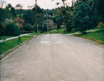
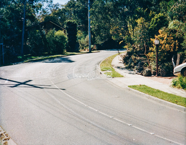
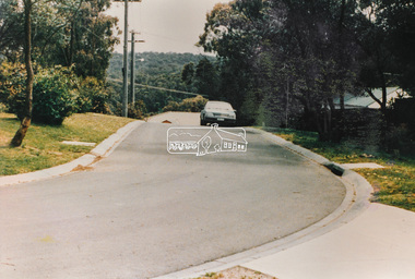
... , consultation • Road construction and maintenance • Bridge construction..., consultation • Road construction and maintenance • Bridge construction ...Date based on other similar display panels visible in images of the Shire of Eltham display at the Eltham Community Festival, 7 November 1987. 20 x 25 cm Shire of Eltham Engineering Department Providing the resources to undertake • Survey, design, consultation • Road construction and maintenance • Bridge construction and maintenance • Street sweeping • Drain and pit cleaning • Traffic engineering installation and maintenance • Garbage collection • Tip management, land reclamation and beautification • Maintenance of community buildings • Provision of community and recreation facilitiesunidentified, display panel, eltham festival, footpaths and gutters, infrastructure, residential, roads, shire of eltham, streets, 1987 -
 Eltham District Historical Society Inc
Photograph - Colour Print, Eltham Shire Council, Unidentified road, Eltham district, c.Oct. 1987
... , consultation • Road construction and maintenance • Bridge construction..., consultation • Road construction and maintenance • Bridge construction ...Date based on other similar display panels visible in images of the Shire of Eltham display at the Eltham Community Festival, 7 November 1987. 20 x 25 cm Shire of Eltham Engineering Department Providing the resources to undertake • Survey, design, consultation • Road construction and maintenance • Bridge construction and maintenance • Street sweeping • Drain and pit cleaning • Traffic engineering installation and maintenance • Garbage collection • Tip management, land reclamation and beautification • Maintenance of community buildings • Provision of community and recreation facilitiesunidentified, display panel, eltham festival, footpaths and gutters, infrastructure, residential, roads, shire of eltham, streets, 1987 -
 Orbost & District Historical Society
black and white photograph, January 1934
... -. wrecking fences, bridges and roads, dumping silt and debris... -. wrecking fences, bridges and roads, dumping silt and debris ...From The Argus (Melbourne) on January 10 1934 "Damage estimated at £500,000 has been caused by the floods in the Orbost district. No loss of life occurred, largely owing to the heroic efforts of rescue parties. Many families spent Monday night on the roofs of houses or in trees, surrounded by deep, rushing flood waters." This 1934 flood was devastating, destroying a section of the 1922 Orbost bridge - the centre span was washed away -. wrecking fences, bridges and roads, dumping silt and debris on the rich river flats and drowning cattle. This is a pictorial record of the 1934 flood, a significant event in the history of Orbost.A black / white photograph of floodwaters. In the middle of the water can be see debris including a large spoked wheel. In the background are houses and fences.on back - "near Hilyer's garage at foot of hill Main Street Caravan Park on right" on front at bottom left - "1934"orbost-flood-1934 flood-orbost