Showing 652 items
matching stawell building
-
 City of Ballarat Libraries
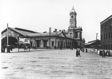
Photograph - Card Box Photographs, Ballarat Railway Station circa 1920
Sign advertising Picnic Excursion Trains to Stawell, Camperdown, Maryborough, Murtoa and Dimboola.ballarat railway station, building, public, persons -
 Hume City Civic Collection
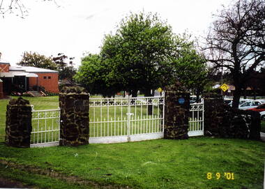
Photograph, St. Andrews Uniting Church gates, 8th September 2001
These are the original wrought iron gates which served as the entrance to St. Andrews Uniting Church, formerly St.Andrews Presbyterian Church. They were erected there in 1922 and were made at H.V.McKay's Sunshine Harvester foundry, at Sunshine. H.V McKay was a member of the Presbyterian Church in Sunbury. Originally the gates opened onto Stawell Street, which ran at an angle between O'Shanassy and Barkly Streets. Apart from a small area leading to the Memorial Hall the rest of Stawell Street has been incorporated in the Village Green in Sunbury.The gates were restored and erected on their original site in 2000. A scanned coloured photograph of white painted wrought iron double gates with two smaller gates on either side and supported by stone pillars. A church building is just beyond a grassed area.st. andrews church, st. andrew's uniting church, wrought iron gates -
 Kew Historical Society Inc
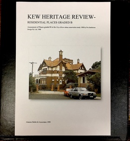
Archive (Sub-series) - Subject File, Kew Heritage Review, Residential Places Graded B, Volume 2, 1999
Graeme Butler & AssociatesProject FilesProvenance OrderBlack 4-Ring binder that includes research about, and an assessment of buildings previously graded B in the City of Kew Urban Conservation Study 1988 by Pru Sanderson Design Pty Ltd. The files were created by the heritage architect Graeme Butler and the paper files include maps, correspondence, title searches, readings, reviews of prior classifications, newspaper and journal articles, directories etc for each property assessed. graeme butler, heritage reviews - kew, 25 mary street, 4 merrion grove, 24 milfay avenue, 24 miller grove, 26 miller grove, 28 miller grove, 82 molesworth street, 27 princess street, 16 queen street, 20 yarra street, 84 walpole street, 118 walpole street, 11 wellington street, 83 walpole street, 25 wellington street, 8 yarra street, 33 wills street, 63 walpole street, 14 vista avenue, 89 studley park road, 12 tara avenue, 75 studley park road, 21 redmond street, 52 walpole street, 51 walpole street, 71 stevenson street, 34 rowland street, 21 stoke avenue, 34 stevenson street, 44 studley park road, 25 studley park road, 13 studley avenue, 2 second avenue, 11 second avenue, 3 second avenue, 36 stawell street, 12 stevenson streetgraeme butler, heritage reviews - kew, 25 mary street, 4 merrion grove, 24 milfay avenue, 24 miller grove, 26 miller grove, 28 miller grove, 82 molesworth street, 27 princess street, 16 queen street, 20 yarra street, 84 walpole street, 118 walpole street, 11 wellington street, 83 walpole street, 25 wellington street, 8 yarra street, 33 wills street, 63 walpole street, 14 vista avenue, 89 studley park road, 12 tara avenue, 75 studley park road, 21 redmond street, 52 walpole street, 51 walpole street, 71 stevenson street, 34 rowland street, 21 stoke avenue, 34 stevenson street, 44 studley park road, 25 studley park road, 13 studley avenue, 2 second avenue, 11 second avenue, 3 second avenue, 36 stawell street, 12 stevenson street -
 Kew Historical Society Inc
Archive (Sub-series) - Subject File, Kew Heritage Review, Residential Places Graded B, Volume 3, 1999
Graeme Butler & AssociatesProject FilesProvenance OrderBlack 4-Ring binder that includes research about, and an assessment of buildings previously graded B in the City of Kew Urban Conservation Study 1988 by Pru Sanderson Design Pty Ltd. The files were created by the heritage architect Graeme Butler and the paper files include maps, correspondence, title searches, readings, reviews of prior classifications, newspaper and journal articles, directories etc for each property assessed.graeme butler, heritage reviews - kew, 4 cameron court, 2 hodgson street, 20 fellows street, 26 fellows street, 23 highbury grove, kew lunatic asylum, kew mental hospital, willsmere, 36 stawell street, 13 studley avenue, 16 studley avenue, 20 studley avenue, raheen, studley park road, beament house, 33 uvadale road, 20 yarra streetgraeme butler, heritage reviews - kew, 4 cameron court, 2 hodgson street, 20 fellows street, 26 fellows street, 23 highbury grove, kew lunatic asylum, kew mental hospital, willsmere, 36 stawell street, 13 studley avenue, 16 studley avenue, 20 studley avenue, raheen, studley park road, beament house, 33 uvadale road, 20 yarra street -
 Kew Historical Society Inc
Archive (Sub-series) - Subject File, D'Estaville (Barry Street), 1958
Various partiesReference, Research, InformationSecondary Values (KHS Imposed Order)Sir William Stawell built the house, D’Estaville, in what is now Barry Street, Kew. The subject file about the house includes sundry items including real estate brochures, newspaper articles/clippings, copies of Australian Heritage and the Victorian Historical Journal (2006) in which there are articles on Stawell and the Victorian Constitution, correspondence between the Society and the national Trust and the Historic Buildings Council relating to the vacant land in Sir William Street (1980) and to D’Estaville itself.d'estaville - barry street - kew (vic), sir william stawell, alma figuerola, historic houses - kew (vic)d'estaville - barry street - kew (vic), sir william stawell, alma figuerola, historic houses - kew (vic) -
Kew Historical Society Inc
Journal, The Kewriosity Sheet Vol.1 No.3 : August 1979
What's doing in Kew for August / p1. We want your news! / p1. Kew Municipal Library: Where children are VIP / p1. 25 years of service: Kew Lions Anniversary / p1. Miss Shepheard retires [Stawell Street Kindergarten] / p1. Studley Park Progress Association / p1. Entertainers needed [Kew Entertainment Workshop] / p1. Rotaract ski weekend / p1. Kew Historical Society: Memorials in Kew / p2. Children's Week 1979 / p2. Limerick of the month / p2. Theatre in Education [Kew High School] / p2. Nursing Mothers Association / p2. Mid-week tennis / p2. [Kew] Swimming Club / p2. Help where it's needed [Sacred Heart Kew Caring Group] / p2. Kew City Bowmen / p2. Holiday help [Meals on Wheels] / p2. Child Development Seminar / p2. Council News: For your safety [Roundabouts; If you're un-building [demolitions]; Traffic School; School Holidays] / p2. Citizens' Advice Bureau / p2.The Kewriosity Sheet (1979-83) was first published in the City of Kew (Victoria) in June 1979 as a two-sided 'community newssheet'. It aimed to: 'share news about Kew happenings and Kew people, and to exchange ideas about living in Kew'. Later issues gradually evolved into a 4-page, quarto sized publication. The Kewriosity Sheet was superseded by the Kew Council publication 'Kewriosity' (1983-1994).non-fictionWhat's doing in Kew for August / p1. We want your news! / p1. Kew Municipal Library: Where children are VIP / p1. 25 years of service: Kew Lions Anniversary / p1. Miss Shepheard retires [Stawell Street Kindergarten] / p1. Studley Park Progress Association / p1. Entertainers needed [Kew Entertainment Workshop] / p1. Rotaract ski weekend / p1. Kew Historical Society: Memorials in Kew / p2. Children's Week 1979 / p2. Limerick of the month / p2. Theatre in Education [Kew High School] / p2. Nursing Mothers Association / p2. Mid-week tennis / p2. [Kew] Swimming Club / p2. Help where it's needed [Sacred Heart Kew Caring Group] / p2. Kew City Bowmen / p2. Holiday help [Meals on Wheels] / p2. Child Development Seminar / p2. Council News: For your safety [Roundabouts; If you're un-building [demolitions]; Traffic School; School Holidays] / p2. Citizens' Advice Bureau / p2. community publications --- kew (vic.), the kewriosity sheet, newsletters - kew (vic.) -
 Kew Historical Society Inc
Plan, Melbourne & Metropolitan Board of Works : Borough of Kew : Detail Plan No.1350, 1910
The Melbourne and Metropolitan Board of Works (MMBW) plans were produced from the 1890s to the 1950s. They were crucial to the design and development of Melbourne's sewerage and drainage system. The plans, at a scale of 40 feet to 1 inch (1:480), provide a detailed historical record of Melbourne streetscapes and environmental features. Each plan covers one or two street blocks (roughly six streets), showing details of buildings, including garden layouts and ownership boundaries, and features such as laneways, drains, bridges, parks, municipal boundaries and other prominent landmarks as they existed at the time each plan was produced. (Source: State Library of Victoria). This plan forms part of a large group of MMBW plans and maps that was donated to the Society by the Mr Poulter, City Engineer of the City of Kew in 1989. Within this collection, thirty-five hand-coloured plans, backed with linen, are of statewide significance as they include annotations that provide details of construction materials used in buildings in the first decade of the 20th century as well as additional information about land ownership and usage. The copies in the Public Record Office Victoria and the State Library of Victoria are monochrome versions which do not denote building materials so that the maps in this collection are invaluable and unique tools for researchers and heritage consultants. A number of the plans are not held in the collection of the State Library of Victoria so they have the additional attribute of rarity.Original survey plan, issued by the MMBW to a contractor with responsibility for constructing sewers in the area identified on the plan within the Borough of Kew. The plan was at some stage hand-coloured, possibly by the contractor, but more likely by officers working in the Engineering Department of the Borough and later Town, then City of Kew. The hand-coloured sections of buildings on the plan were used to denote masonry or brick constructions (pink), weatherboard constructions (yellow), and public buildings (grey). MMBW Plan No. 1350 depicts the western end of Studley Park on the north side of the Studley Park Road. ‘Raheen’, then the home of Sir Henry Wrixon is named, the plan identifying those parts of the house that were built of brick and timber. The two houses between Raheen and the River Yarra are also shown. Other parts of the plan show neighbouring streets: Yarra Street, Studley Park Avenue, Studley Street and Fenwick Street. Each, apart from Fenwick Street was subsequently renamed. At the corner of Fenwick and Stawell Streets, the home of Joseph Butterworth Coombs, later called ‘Hope Mansell’, is represented but unnamed.melbourne and metropolitan board of works, detail plans, mmbw 1350, cartography -
 Kew Historical Society Inc
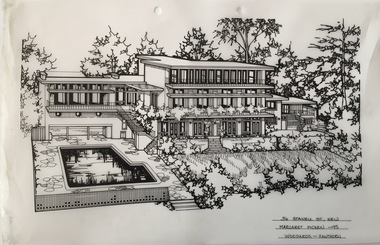
Drawing - Property Illustration, Margaret Picken, 36 Stawell Street, Kew, 1995
... & associates - buildings -- kew (vic.) 36 STAWELL ST., KEW / MARGARET ...After training as a Cartographic Draftsman within the mining industry, I worked as a property illustrator for real estate firms in the eastern suburbs of Melbourne for 22 years from 1983. I initially photographed houses with a Polaroid camera and made a 'thumbnail' sketch while there. The photos were used to scale off a sketch in pencil and then that sketch was overlaid with drafting film and the 'pen and ink' completed. The pens I used were the Rotring ‘Rapidigraph’ drafting pens. The ink was also made by Rotring (German).The film was ‘Rapidraw’, polyester drafting film, double matte. It takes a very fine line and doesn’t bleed. As well as house sketches, there were often floor plans and site plans ordered. Aerial sketches were ordered when the property needed an overall view. (Margaret Picken, 2020)36 Stawell Street in Kew was built to a design by Anatol Kagan & Associates in 1952. The drawing, dating from 1995, is one of a series of property illustrations created by Margaret Picken for real estate agents in Melbourne between 1983 and 2005. Each work is signed and dated by the artist.Gift of Margaret Picken, 2020Pen and ink drawing on drafting film of 36 Stawell Street, Kew by Margaret Picken.36 STAWELL ST., KEW / MARGARET PICKEN ~95 / WOODARDS ~ HAWTHORNartist -- margaret picken 1950-, architectural drawings -- houses -- kew (vic.), 36 stawell street - kew (vic), anatol kagan & associates - buildings -- kew (vic.) -
 Sunbury Family History and Heritage Society Inc.
Photograph, c 1920s
The 'Meeise' French car is parked outside the former Mechanics Institute Hall in Stawell Street, Sunbury. J Eadie was responsible for the building of the hall in 1885 and the foundation stone was laid by Lady Janet Clarke. The former Shire of Bulla conducted their council meetings in the hall from 1923 until 1956 when new offices were built in Macedon Street. Later the RSL took over occupancy of the hall and it became known as the Memorial Hall. In the early 1970s Stawell Street was cut off to traffic and incorporated into the Village Green.Over the years the Memorial Hall has been the venue for many community events from debutant balls, flower shows, local gatherings, celebrations and markets to name a few.A sepia photograph with a cream border of a tree lined street with a building in the foreground and a vintage car parked outside the building. Tall pine trees are growing behind the fenceline.mechanics institute, shire of bulla -
 Sunbury Family History and Heritage Society Inc.
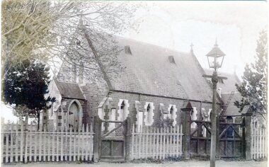
Photograph, St. Mary's Anglican Church, Pre1910
This is an early photograph of St. Mary's Anglican Church in Sunbury. On 13th October 1863, the Government granted one acre of land on the corner of Stawell and O'Shanassy Streets for the building of a church. he first service was held on 24th November 1867. After that date subsequent additions were made. The gas lamp outside the church indicates that the photograph was taken before electric power was installed in Sunbury. St. Mary's Anglican Church is one of the earliest places of worship to be built in Sunbury.A non-digital sepia post card photograph of a small bluestone church with a slate roof with a wooden picket fence and two gates across the front. A gas lamp is on the pathway. Peter Collett's signature is on the back as well as a sticker with number 7 written on itst. mary's church of england., o'shanassy street, stawell street -
 Sunbury Family History and Heritage Society Inc.
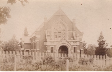
Photograph, St. Andrew's Presbyterian Church
The Government first granted land for the building of a Presbyterian Church in Sunbury in Stawell Street and Barkly Street, in 1864 and a smaller building was later erected on the site. In 1904 Rev Goyen pressed for a brick church rep[lace the smaller weather board building and the foundation stone was laid for the new church was laid by Mrs. John Duncan on 17th August 1904 and the new church opened by Lady Clarke on 13th November 1904.The Presbyterian Church was one of the earliest churches to be established in Sunbury along with a school.A non-digital sepia photograph in post card format of the front view of a brick church with a light picket fence across the front. -
 Sunbury Family History and Heritage Society Inc.
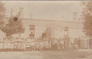
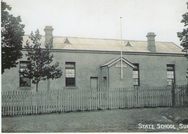
Photograph, Sunbury State School
The first building which housed Sunbury State School No.1002 was built on the corner of Macedon and Stawell Streets in the early 1870s and functioned as the local State School until 1912 when a sturdier red brick structure replaced on the same site. In 1999 Sunbury State School was relocated in the former Industrial School heritage buildings in Jacksons Hill. The existing building in Macedon Street was incorporated into the Sunbury Community Health Centre. The school in the photograph is the original Sunbury State School NO. 1002 building, where many early Sunbury residents attended. A non-digital black and white photograph in post card format of a crowd of children outside a school building. Four teachers are standing on the RHS of the image.sunbury state school no. 1002, stawell street, macedon street, schools -
 Sunbury Family History and Heritage Society Inc.
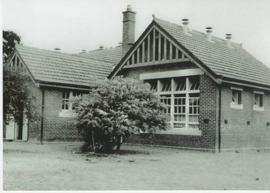
Photograph, c1910 - 1920s
The photo is of the Sunbury State School No. 1002, which replaced an earlier building. The Federation style red-brick school was built in 1911 and was officially opened on 2nd May 1912. An extra room was added in 1945 to accommodate increased enrolment. In 1999 the school closed at the Stawell Street site and the students relocated to the former and refurbished bluestone Industrial School in Jacksons Hill. The former red-brick school building is now part of the Sunbury Community Health Centre complex.Many former and present-day residents in Sunbury have attended this school over the years.A black and white photograph of a small school building. It is a federation style building with brick walls and a tiled roof.sunbury state school no. 1002. -
 Sunbury Family History and Heritage Society Inc.
Photograph, C1880 - 1910
The building in the photograph was the first Sunbury State School No.1002. Prior to the school being built, lessons were conducted in the Presbyterian Church. After parents organised a petition in 1869 for the school to be housed in a proper building and a committee of management was formed, work on a new school building commenced. The old building had many structural deficiencies and the red brick building was built on the same site in 1911. A black and white photograph of an austere looking rendered building with a flagpole attached to a small portico at the entrance of the building. The roof is corrugated iron and has two air vents and two chimneys on it. There is a picket fence with a gate across the front and a tree is growing in the front.sunbury state school no. 1002., macedon street, stawell street -
 Sunbury Family History and Heritage Society Inc.
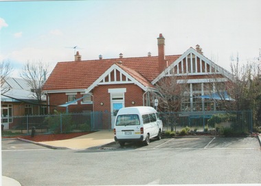
Photograph, c 2000
The building is the former Sunbury State School 1002, which was relocated to the former Industrial School in Jacksons Hill in 1999. The Federation Style building replaced an earlier school building in 1912 and it is now incorporated into the Sunbury Community Health Centre complex. A school in Sunbury has occupied the site on the corner of Macedon and Stawell Streets from 1870 to 1999. A coloured photograph of a red brick single storey Federation style building with an orange tiled roof. A white minivan is parked outside the building and a modern cream brick building is visible on the LHS of the photograph.sunbury state school no. 1002., sunbury community health centre -
 Stawell Historical Society Inc
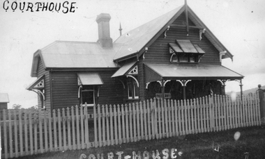
Photograph, Kodak Australia, Landsborough Court House 1925, C 1925
... Stawell Historical Society Inc 46 Longfield St Stawell ...Weatherboard building corrugated iron roof decorative awnings on windows. Landsborough Court House 1925. Picket fence in foreground. Courthouse top left. Court-House bottom centre in white. -
 Stawell Historical Society Inc
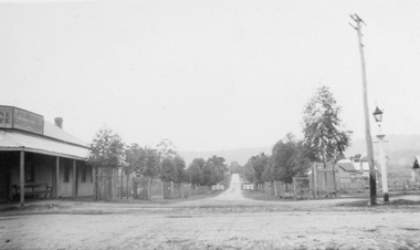
Photograph, Landsborough Scene -- McKenzie Street 1924
B/W photo of Landsborough McKenzie Street scene taken 1924. Tree lined street wooden building with verandah on left Telegraph pole and light on right.Black and White Photograph Postcard of a tree lined street - wooden building with veranda on the left - on the right telegraph pole. also a light pole. Two (2) Photographs, One Postcard and one enlargementon Rear: Post Card Correspondence Address Only In Grey Print Kodak Australia forming a square, Kodak top and Bottom, Australia Left and Right. In blue ink hand written "Landsborough looking up towards the school 1924 with 1924 Underlined. Bottom right " Coffee Palace"commercial -
 Stawell Historical Society Inc
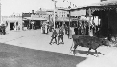
Photograph, Main Street Stawell corner of Wimmera Street with Stabbs Coach Building visable c1920's, 1920
Sepia photo of Stawell Main Street Scene. Stabb's Coach Building on corner of Wimmera Street visible. C1920's. Possibly Easter bunting hanging in the street.Sepia Photograph of a scene in a commercial area. People in the Street. A Cow in the foreground. Stawell from the side of the P.O. (Nell Kingston)stawell -
 Stawell Historical Society Inc
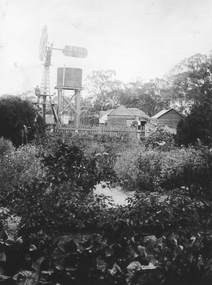
Photograph - Yard Scenes at 'Whitehall', Hutchings Farm “Whitehall” -- 3 Photos
Hutchings family property “Whitehall” 3 Scenes Shows large Haystacks Sheds Cows extensive Garden. Avenue of trees. These copies were taken from the Hutchings Family album.Three (3) Sepia Photographs. 204 Titled Whitehall Avenue: An avenue with wooden fences including people on on left three on right including one woman. 204.1 Titled Yard at Whitehall: 4 Men with herd of cows in foreground, man in front holding a metal bucket. Large Hay stacks behind. wooden shed with metal roof on right. 204.2 Part of Whitehall: Windmill and wooden buildings behind Wooden Picket fence in background. 204: Whitehall Avenue 204.1 Yard at Whitehall 204.2: Part of Whitehall All enclosed in a box, which is above a line of solid triangles over a thin linestawell -
 Stawell Historical Society Inc
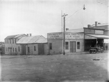
Photograph, J.H. Stabb coach building factory with car parked in front c1920's, c 1920's
J.H. Stabb coach building factory 1920's with car parked in front. B/W Photograph of weatherboard factory. with a two sided sign reaing Stawell Coach Factory J.H. Stabb Coach Builders & Wheelwright. There is a car on the right of the photgraph. Tow shop to the right of factory with a veranda. There is Light pole on the corner.Sign Reads Stawell Coach Factory Trimming a Speciality J.H. Stabb Coach Builders & Wheelwrightstawell industry, j.h. stabb, coachbilders -
 Stawell Historical Society Inc
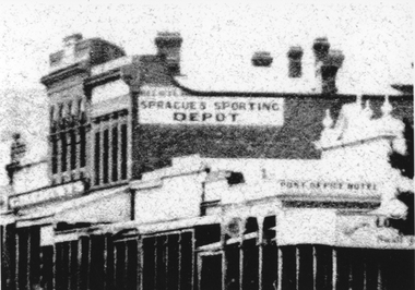
Document, Sprague Sporting shop in Main Street Stawell with the Sprague Trophy
... grampians Sprague Sporting Depot building Main Street stawell ...Sprague Sporting Depot building Main StreetB/W Photo of a street scape showing various buildings including Pots office Hotel & Sprague's Sporting Depot Copy from No.2 Street Scene Centering on Spragues shopSprague's Sporting Depot Post Office Hotelstawell, sprague sporting depot, street scene -
 Stawell Historical Society Inc
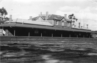
Photograph, Railway Station Stawell
Railway Station Stawell. B/W photo showing large two storey brick station with long verandah over platform in heavy shade. Rail lines in foreground. This Photograph is a copy of a Negative owned by the Society - paid from a grant 1991. This Photograph is of Stawell Railway Station.B/W. Photograph of Stawell Railway Station taken from acroos the railway tracks. Also showing two vechiles of the far right. the centre of the building is two story stawell railways, transport, mark dadswell -
 Stawell Historical Society Inc
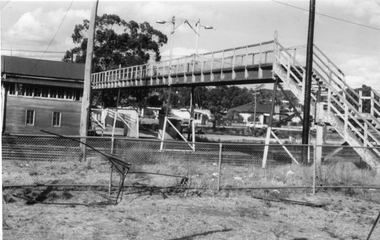
Photograph, Railway Step Bridge Stawell with signal box in the background
This Photograph is a copy printed from a negative owned by the Society - Paid from grant 1991. This is a Photograph of the footbridge over the rail yad at Stawell. A Signal Box in the Background. The Signal box was demolished some years ago. The Footbridge was demolished in 1991.Black and White Photograph of a bridge with wooden handrails. wooden building on far side of bridge. Housing in the backgroundstawell, railway -
 Stawell Historical Society Inc
Photograph, Houses in Houston Street -- 4 Photos
Houston St. & Houses. Series of 4 photosFour Colour Photgraphs 225 of a brick building with a palm tree in front. a white car in the front on the left. 38 Houston Street 225a - white brick house with arched verandah, and tiled roof. M.T. White 42Houston Street. 225b - Withe Wetherboard miners cottage, wiith red corregated roof. next to a similar building with faded grey? roof. 225c a view of houston street lloking westtoward the Grampians 225d - A house light brow in colour with two chimneys and an upper window with shutters, low brick fence topped with arched iron railings gateway covered with an archway with tiled topstawell houses -
 Stawell Historical Society Inc
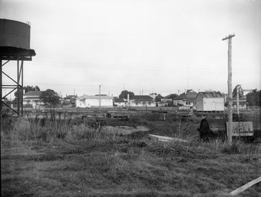
Photograph, Railway Yards looking towards Wakeham Street c1960, approx 1965
Railway Yards Stawell looking towards Wakeham Street with water tank on left. c1960B/W Photgraph of Rail yards looking towards Wakeham Street. View shows water tank which was used in Steam engine days. house on left, Cnr. Sloane & Wakeham Streets No. 50 was adapted into two flats ( Possibly in the 190's. The weatherboard building on the right was the headquarters for the Stawell Homing Club ( Pigeon Club) Circa 1960's The Word Shell is visible on a train carriage.stawell railways transport -
 Stawell Historical Society Inc
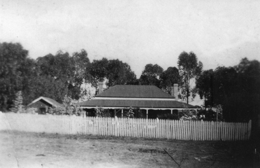
Photograph, “Vinelea” Homestead once ownd by Mr John Patrick Monoghan
“Vinelea” Homestead with picket fence in front and trees in rear. MonaghanB/W Photgraph of of a house and another buuilding with a wooden picket fence in front. Two chimneys on the right side f th ehouse and one on the left, the both buildings have iron roofs.stawell -
 Stawell Historical Society Inc
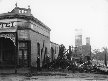
Photograph, Mr Gustav Mahnke’s Bakery Shop on the corner of Main & Wimmera Streets Stawell -- burnt out by fire 1922, 1922
Ruins of Gustav Mahnke’s Bakery Shop Corner of Main Street and Wimmera Street Stawell destroyed by fire 1922. The Chimneys left standing would have belonged to the ovens. Firemen Left R. Chapman - extreme right Alf Pickering , inspecting damage. The Post Office Hotel and the destroyed bakery on the corner of Main and Wimmera Streets. Gustav Mahnke, a German, was a borough Councilor, Mayor for three successive terms - 1904-07. Note extreme right in the backgorundbehind trees - Stawell Baths.B/W. Photograph of the ruins of a burnt building, next to a Hotel with four men.Part of a sign reading "TEL"stawell business streetscape -
 Stawell Historical Society Inc
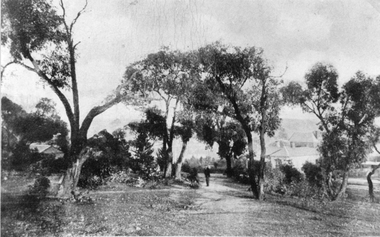
Photograph, Man standing on pathway on Church Hill Stawell West looking West
Man standing on pathway on Church Hill Stawell West looking West. Anglican Manse and Houses are on right beyond the trees. Two story building is Grammar School residence in Smith Street.On Church Hill, Stawell Weststawell education -
 Stawell Historical Society Inc
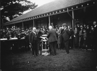
Photograph, Stawell Technical School c1920s opening of new wing of building
... grampians Stawell Technical School. Opening of New Building 1920s ...Stawell Technical School. Opening of New Building 1920sstawell education -
 Stawell Historical Society Inc
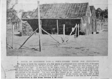
Photograph, Kerosene Tin House built by James Doyle of Stawell West
... of Stawell West. stawell buildings Kerosene Tin House built by James ...Kerosene Tin four roomed House build by James Doyle of Stawell West.stawell buildings