Showing 652 items
matching survey department
-
 Department of Health and Human Services
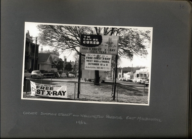
Photograph, X-ray caravan at the corner of Simpson St and Wellington Parade East Melbourne 1962 - Department of Health - Tuberculosis Branch - Chest X-Ray Surveys program
Photo from Accession AS/14/612 -
 Department of Health and Human Services
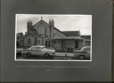
Photograph, X-ray caravan on the grounds of St Francis Church Lonsdale St 1962 - Department of Health - Tuberculosis Branch - Chest X-Ray Surveys program
Photo from Accession AS/14/612 -
 Department of Health and Human Services
Photograph, X-ray caravan on the grounds of St Francis Church Lonsdale St 1962 - Department of Health - Tuberculosis Branch - Chest X-Ray Surveys program
Photo from Accession AS/14/612 -
 Department of Health and Human Services
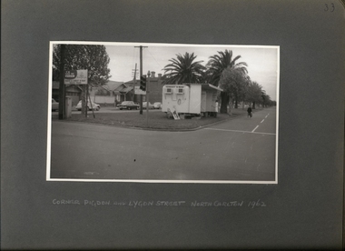
Photograph, Tuberculosis Campaign - X-ray caravan on the corner of Pigdon & Lygon St North Carlton 1962 - Department of Health - Tuberculosis Branch - Chest X-Ray Surveys program
Photo from Accession AS/14/612 -
 Department of Health and Human Services
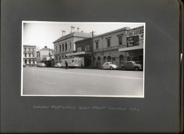
Photograph, X-ray caravan outside of Carlton Post Office Elgin St 1962 - Department of Health - Tuberculosis Branch - Chest X-Ray Surveys program
Photo from Accession AS/14/612 -
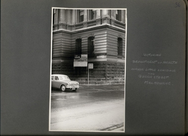 Department of Health and Human Services
Photograph, Victorian Department of Health corner of Little Lonsdale & Queen St 1962 - Hillman Minx Car in Foreground - Department of Health - Tuberculosis Branch - Chest X-Ray Surveys program
Photo from Accession AS/14/612 -
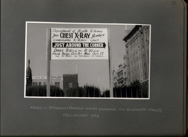 Department of Health and Human Services
Photograph, "Free Chest X-Ray Service" "Caravan X-Ray Unit" "Just Around The Corner" - Department of Health - Tuberculosis Branch - Chest X-Ray Surveys program
Photo from Accession AS/14/612 -
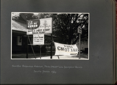 Department of Health and Human Services
Photograph, Anti Tuberculosis Campaign - "TB Can Be Cured" "Be sure you're free" "Have a Chest X-Ray Each Year"- Billboard & Signage at Junction of Birdwood Ave, Park St & Domain Rd South Yarra 1962 - Department of Health - Tuberculosis Branch - Chest X-Ray Surveys program
Photo from Accession AS/14/612 -
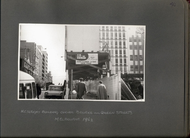 Department of Health and Human Services
Photograph, Anti Tuberculosis Campaign - "TB Can Be Cured" "Be sure you're free" "Have a Chest X-Ray Each Year - Billboard & Signage at H C Sleigh's Building Corner of Bourke & Queen Sts 1962 - Department of Health - Tuberculosis Branch - Chest X-Ray Surveys program
Photo from Accession AS/14/612 -
 Department of Health and Human Services
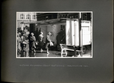
Photograph, Anti Tuberculosis Campaign - People queuing & exiting X-ray caravan on a wet day outside Elizabeth St Post Office Melbourne 1962 - Department of Health - Tuberculosis Branch - Chest X-Ray Surveys program
Photo from Accession AS/14/612 -
 Department of Health and Human Services
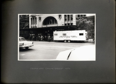
Photograph, X-ray caravan outside of the Centreway Arcade on Collins St 1962 - Department of Health - Tuberculosis Branch - Chest X-Ray Surveys program
Photo from Accession AS/14/612 -
 Department of Health and Human Services
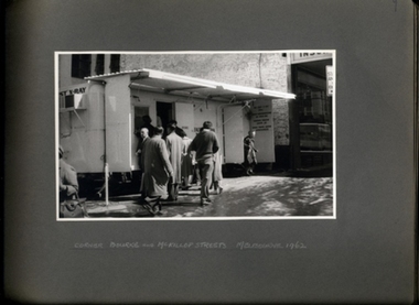
Photograph, Anti Tuberculosis Campaign - People queuing and exiting X-ray caravan on a wet day on the Corner of Bourke & McKillop Streets Melbourne 1962 - Department of Health - Tuberculosis Branch - Chest X-Ray Surveys program
Photo from Accession AS/14/612 -
 Moorabbin Air Museum
Document (Item) - US War Department Air Corps Flutter Survey of two radio antenna
... US War Department Air Corps Flutter Survey of two radio... Moorabbin melbourne Document US War Department Air Corps Flutter ... -
 Bendigo Historical Society Inc.
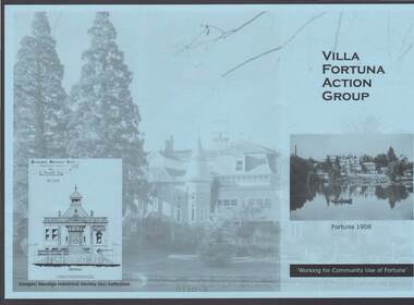
Document - FORTUNA COLLECTION: VILLA FORTUNA ACTION GROUP
Blue tri-fold pamphlet titled 'Villa Fortuna Action Group' which has a photo of Fortuna and the lake on the front with Fortuna 1908 under the photo and Working for Community Use of Fortuna. On the inside is a brief history of Fortuna, What the Action Group plans to do and Potential Activities. There is also a photo of the Billiard Room, criteria 1908 and another of the exterior of the building. There is also a space to fill in for a Joining Fee and Annual Membership Fee of $10 each. On a lighter photo on the back page is a proposed drawing of the Entrance Hall.bendigo, clubs, villa fortuna action group, fortuna, army survey regiment, theodore ballerstedt, vahland, getzschmann, 180 mine, george lansell, roman bath, pompeii fountain, department of defence, the villa fortuna action group, bendigo historical society inc. -
 Bendigo Historical Society Inc.
Legal record - Right to occupy a residential area
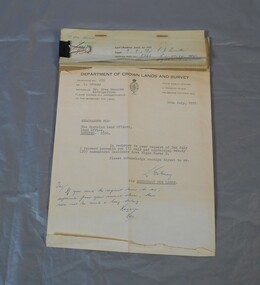
Four books of stubs. Originally the books had 20 right to occupy residence area forms. The stubs record the date of issue, the replacing right No., the fee paid, the receipt no. and a signature. only one of the books has the original form attached, two of the books have handwritten notes attached. One has a typewritten letter from a Mr. L. Gibney of the department of Crown lands and survey dated 24th July 1972 addressed to the district land officer, Bendigo. In the letter Mr. Gibney tells the officer in Bendigo that a pad containing 20 unnumbered residence area right forms D. The dates on the stubs are 17/04/1961, 16/04/1971, 07/09/1972, 08/05/1975land sales, right to occupy, government -
 Bendigo Historical Society Inc.
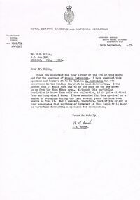
Document - PETER ELLIS COLLECTION: LETTER, 24th September, 1973
Letter, dated 24th September, 1973, to Mr P N Ellis from A B Court of the Royal Botanic Gardens and National Herbarium. In the A B Court thanks Mr Ellis for his letter and for the specimen of Acacia hakeoides. He was hoping it would turn out to be the same as the one known to him from the Moon Mines area. He had searched for this species? During the last several years but had been unable to find it. He suggest that if Mr Ellis or his associates find anything of interest in the locality it might be worthwhile forwarding a specimen for examination. Signed A B Court.communication, postal, letters, peter ellis collection, department of crown lands and survey victoria, royal botanic gardens and national herbarium, p n ellis, moon mines area, a b court -
Bendigo Historical Society Inc.
Plan - SANDHURST BOYS CENTRE SITE PLANS: LISLE STREET UNITS
16 Working drawings including Floor Plans and Elevations Prepared by Michael DeVincentis, Architects; Wellington St Strathfieldsaye. October-November 1995. Scale 1:200. No 9538. Also Survey Plan for Lot 69D 3950 Sq m. Location unknown 16.02.2023.plan, bendigo, institutions, victoria. department of planning and development -
Bendigo Historical Society Inc.
Map - PANNOOMILLOO : COUNTY OF BENDIGO, 1957
... at the Department of Lands and Survey,1957. Price 2/-. (number 412 in Map... at the Department of Lands and Survey,1957. Price 2/-. (number 412 in Map ...Map. Pannoomilloo, County of Bendigo, Pannoobamawm, Milloo, Warragamba, Diggorra, Property Allotments. Drawn and Reproduced at the Department of Lands and Survey,1957. Price 2/-. (number 412 in Map Cupboard 1 ).W.M. Houston, Government Printer, Melbourne.bendigo, hospital -
Bendigo Historical Society Inc.
Map - WANURP: COUNTY OF BENDIGO, 1/12/33
... at the Department of Lands and Survey, Melbourne, Price 2/-. 1/12/33..., Pannoobamawm. L422+. Photo-Lithographed at the Department of Lands ...Map. Wanurp, County of Bendigo, Terrick Terrick East, Mitiamo, Dingee, Milloo, Pannoobamawm. L422+. Photo-Lithographed at the Department of Lands and Survey, Melbourne, Price 2/-. 1/12/33 ( number 411 in Map Cupboard 1 )H.J. Green, Government Printerbendigo, hospital -
Bendigo Historical Society Inc.
Map - PANNOOBAMAWM : COUNTY OF BENDIGO, 1957
... . Drawn and reproduced at the Department of Lands and Survey, 1957... and reproduced at the Department of Lands and Survey, 1957, Price 2 ...Map. Pannoobamawm, County of Bendigo, Terrick Terrick East, Wanurp, Pannoomilloo, Bamawm, Turrumberry, property allotments. Drawn and reproduced at the Department of Lands and Survey, 1957, Price 2/-. (number 410 in Map Cupboard 1 ).W.M. Houston, Government Printer, Melbourne.bendigo, hospital -
Bendigo Historical Society Inc.
Map - NERRING : COUNTY OF BENDIGO, August 1952
... at the Department of Lands and Survey, Melbourne, Victoria, August 1952..., Neilborough, Yarraberb. Drawn and Reproduced at the Department ...Map. Nerring, County of Bendigo, Leichardt, Marong, Sandhurst, Huntly, Neilborough, Yarraberb. Drawn and Reproduced at the Department of Lands and Survey, Melbourne, Victoria, August 1952, Price 2/-.( number 409 in Map Cupboard 1).J.J. Gourley, Government Printer, Melbourne.bendigo, hospital -
 Bendigo Historical Society Inc.
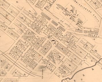
Map - MARKS COLLECTION: MAP SANDHURST 1867
... for. On bottom of map: 'Lithographed at the Department of Lands... at the Department of Lands and Survey by D. Henderson, 20 February, 1867 ...Original map: Sandhurst 1867, shows central Bendigo and surrounds, including police camp, stockade, 'old cemetery', reserve for. On bottom of map: 'Lithographed at the Department of Lands and Survey by D. Henderson, 20 February, 1867'. On top RH corner 'Sheet No 1 Sandhurst'.map, bendigo, 1867 sandhurst map -
 Bayside Gallery - Bayside City Council Art & Heritage Collection
Map, Department of Crown Lands and Survey et al, Moorabbin, County of Bourke, Government Roads, 1920
... Department of Lands and Survey... from the Secretary for Department of Lands and Survey (dated 26... for Department of Lands and Survey (dated 26/2/1934), notifying ...The cadastral map of the Parish of Moorabbin in Victoria (L.6104) shows parish boundaries and land ownership 1920 when Sandringham was a Town. The government roads have been coloured in red pencil.moorabbin, county of bourke, map, plan, land subdivision, land titles, foreshores, hampton, beaumaris, highett, cheltenham, department of lands and survey, land owners, cartographic material, brighton, sandringham, town of sandringham, government roads -
 Bayside Gallery - Bayside City Council Art & Heritage Collection
Map, Department of Lands and Survey, Land under the control of the City of Sandringham, 1962
... department of lands and survey...Print. Map in black ink on cream paper by the Department...Department of Lands and Survey... cheltenham department of lands and survey cartographic material ...The cadastral map showing land under the control of the City of Brighton in 1962.map, plan, foreshores, sndringham, hampton, beaumaris, cheltenham, department of lands and survey, cartographic material, moorabbin, black rock, street map, city of sandringham, board of lands and works -
 Bayside Gallery - Bayside City Council Art & Heritage Collection
Photograph, Department of Crown Lands and Survey, Victoria, Melbourne Project: Brighton and Elwood, 1976
The Department of Crown Lands and Survey (1857-1983) was responsible for the administration of survey and mapping and the sale, occupation and management of crown land throughout its existence. This aerial photograph shows parts of Brighton and Elwood and was taken on 1 December 1976brighton, elwood, department of crown lands and survey, aerial photograph, elsternwick park, point ormond, north road, ormond esplanade, st kilda street, glen huntly road, bayside, port phillip bay, map, cartographic material, melbourne project 1976 -
 Bayside Gallery - Bayside City Council Art & Heritage Collection
Photograph, Department of Crown Lands and Survey, Victoria, Melbourne Project: Brighton, Hampton, Sandringham, 1976
The Department of Crown Lands and Survey (1857-1983) was responsible for the administration of survey and mapping and the sale, occupation and management of crown land throughout its existence. This aerial photograph shows parts of Brighton, Hampton and Sandringham and was taken on 1 December 1976brighton, department of crown lands and survey, aerial photograph, bayside, port phillip bay, map, cartographic material, hampton, sandringham, green point, sandringham yacht club, south road, beach road, hampton street, melbourne project 1976 -
 Bayside Gallery - Bayside City Council Art & Heritage Collection
Photograph, Department of Crown Lands and Survey, Victoria, Melbourne Project: Brighton, 1976
The Department of Crown Lands and Survey (1857-1983) was responsible for the administration of survey and mapping and the sale, occupation and management of crown land throughout its existence. This aerial photograph shows parts of Brighton and was taken on 1 December 1976brighton, department of crown lands and survey, aerial photograph, bayside, port phillip bay, map, cartographic material, melbourne project 1976, brighton yacht club, middle brighton baths, north road, st kilda street, new street -
 Bayside Gallery - Bayside City Council Art & Heritage Collection
Photograph, Department of Crown Lands and Survey, Victoria, Melbourne Project: Brighton and Hampton, 1976
The Department of Crown Lands and Survey (1857-1983) was responsible for the administration of survey and mapping and the sale, occupation and management of crown land throughout its existence. This aerial photograph shows parts of Brighton and Hampton and was taken on 1 December 1976. brighton, department of crown lands and survey, aerial photograph, bayside, port phillip bay, map, cartographic material, melbourne project 1976, brighton yacht club, middle brighton baths, hampton, green point, brighton beach, south road, the esplanade, hampton street -
 Bayside Gallery - Bayside City Council Art & Heritage Collection
Photograph, Department of Crown Lands and Survey, Victoria, Brighton, Elwood and Elsternwick, c. 1965-71
The Department of Crown Lands and Survey (1857-1983) was responsible for the administration of survey and mapping and the sale, occupation and management of crown land throughout its existence. This aerial photograph shows parts of Brighton, Elwood and Elsternwick and was taken circa 1965-71.brighton, department of crown lands and survey, aerial photograph, bayside, port phillip bay, map, cartographic material, elwood, elsternwick, elsternwick park, elwood tram depot, elwood pier, new street, glen huntly road, st kilda street, nepean highway -
 Bayside Gallery - Bayside City Council Art & Heritage Collection
Photograph, Department of Crown Lands and Survey, Victoria, Brighton, Brighton East and Bentleigh, c. 1965-71
The Department of Crown Lands and Survey (1857-1983) was responsible for the administration of survey and mapping and the sale, occupation and management of crown land throughout its existence. This aerial photograph shows parts of Brighton, Brighton East and Bentleigh and was taken circa 1965-71.brighton, department of crown lands and survey, aerial photograph, bayside, port phillip bay, map, cartographic material, bentleigh, brighton east, dendy park, dendy street, centre road, nepean highway, south road, football