Showing 1235 items matching "the gap"
-
 Halls Gap & Grampians Historical Society
Photograph - B/W, C 1880
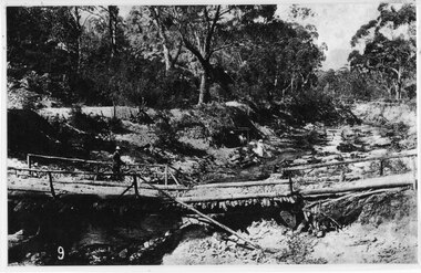
This photo shows the first Delley's Bridge, built to cross the Fyans Creek to provide access to Halls Gap and beyond in the 1880's. The bridge was swept away a number of times in floods. This bridge was replaced by a higher timber structure but constant erosion of the creek bank eventually led to its replacement by a timber and concrete structure. After nearly 50 years of its use, wear and tear necessitated a fourth bridge to be erected in 2001.A log bridge across a creek with a man standing on the bridge. A woman in a white dress and hat is beside the creek and a man is standing near her on the bank. In the left background a house can just be seen through the trees.structures, bridges -
 Kiewa Valley Historical Society
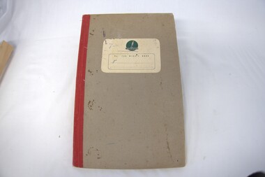
Book - Minute book of the Progress Association Ladies' Auxilary, Minute book of the Progress Association Ladies' Auxilary, 25th February 1960 to 29th February 1968
This is the 1st minute book for the Mount Beauty Progress Association Ladies Auxilary. The first meeting was held on 25th February 1960. At this time the construction of the Kiewa Hydro Electric Scheme was coming to a close and the town of Mount Beauty and its infrastructure was being handed over by the State Electricity Commission of Victoria (SECV) to the Bright Shire. Homes and businesses were sold and residents were having to 'fill in the gaps' for services that had been provided by the SECV.The Mount Beauty Progress Association was formed by community members to improve and enrich the lives of people in the early days of independence from the State Electricity Commission of Victoria as construction of the Kiewa Hydro Electric Scheme was coming to a close and the town and its infrastructure was being handed over to the Bright Shire.Foolscap Ritewell No. 246 Minute Book with red cloth spine and thick brownish cardboard cover. Label on front cover - Cream with "Ritewell (in green over logo) / No 246 Minute Book (printed in green)kiewa hydro electric scheme; bright shire; mount beauty progress association; fund raising. -
 Kiewa Valley Historical Society
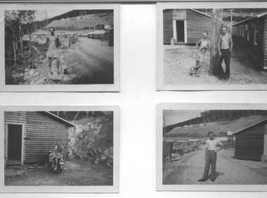
Photograph - 8 Black and white photographs - SECV, Unknown
All eight photographs have been taken at a workmen's camp erected by the State Electricity Commission to house workmen during the construction of the Kiewa Hydro Electric Scheme. These were established in close proximity to various work centres - Junction Camp at Bogong Village, three camps at Mt. Beauty, West Kiewa, Clover Dam and Clover Flat, Howman's sawmill and Howman's Gap, Rocky Valley, Langford's Gap, Pretty Valley, Mountain Creek and Big Hill. These photos have not been identified as to which camp they are taken but typical of the type of accommodation for wages personnel. They followed a general design and layout. There was a mess and recreation hall as well as a building for general trading and postal facilities (this conducted by proprietors of trading stores in Mt. Beauty and Bogong). Originally the rooms accommodated 2 men but later there was a demand for single rooms - the floor size then being 10 feet x 8 feet and furnished with a bed, small table and chair and cupboard with hanging space. The first camps were erected in 1940 and the last was removed in 1962.These photographs are of historical significance as they show the type of accommodation provided for wages personnel working on the Hydro Electric Scheme between 1940 and 1960.Eight small black and white photographs of unknown person and workmen's camp.All photos have been stamped on the back - Two "965U" in red, four "S80 " in green (indistinct) and two "141" in red.workmen's camps, kiewa hydro electric scheme, accommodation, secv, camps on kiewa hydro electric scheme, west kiewa -
 Stawell Historical Society Inc
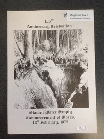
Book, Stawell Water Supply, Stawell Water Supply - Commencement of Works, 18th February 1875, 2000
125th Anniversary celebration Of the Stawell water Supply Commencement of works 18th February 1875Grey Paper cover with B/w/ drawing of people around a large trench with three people at the bottom. ((taken from Illustrated Australian News 24th March 1875) and black print125th Anniversary Celebration Stawell Water Supply Commencement of works 18th February, 1875 On Rear Cover Norther Grampians Shire Council Inc Logo Grampians Water inc logo Parks Vicotria inc logo Halls Gap & Grampians Histprical Society. Inc Logo Stawe;; Historical Society Inc. ic Logostawell water supply d'alton -
 Halls Gap & Grampians Historical Society
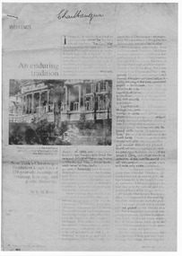
Document - Fax of article (magazine/newspaper)
The article is c.1993. Chautauqua peak is named after the Chautauquans, who held summer camps in Halls Gap in the 1890s. NOTE: Additional images are second and third pages, and a Microsoft Word file which includes the text of all three pages. A PDF file of an "augmented copy of the fax (with the more difficult to read sections clarified in pencil) is also available in the \Pictures\MP Navigator\2009_09_-02 directory on the computer (as there is not further space to attach it to this record)A copy of a three page National Geographic Traveler article entitled 'An enduring tradition'. The article describes the reporter's trip to Lake Chautauqua where the Chautauqua Institution was founded, and includes historical information about the Chautauquans.Chautauqua written in ball-point pen on top of front page.media, magazine articles -
 Stawell Historical Society Inc
Photograph, Char-A-Banc belonging to Withers Bus Tours with a group of people in front of Sloane's & Scotchman Mining Co's Poppet Head c 1920
Char-A-Banc belonging to Withers Bus Tours later Pioneer Tours and group of people in front of Sloane's & Scotchman Mining Co Poppet Head upper Main Street Stawell. Withers Tours, later named Pioneer Tours ran regular tourist buses from Melbourne to Stawell and Halls Gap area in a successful business. They later expanded to Sydney and other interstate destinations. Founder was W.A. Withers born at Moyston and became a successful businessman in Melbourne.Early 1920's open bus with a group or people (tourists) in front of Poppet Head and shaft of Sloane & Scotchmans Mine.mining, transport, tourism -
 Phillip Island Conservation Society Inc.
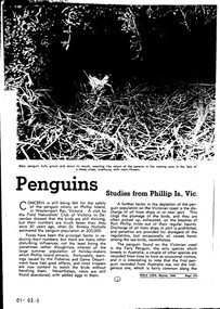
Work on paper - Newspaper cutting, "Penguins. Studies from Philip Is., Vic", Published March 1948
Phillip Island's Little Penguin and other bird species populations became the popular subjects of field naturalist and bird observer field trips from the late 19th century. By 1948 the decline of the Little Penguin population on the island was very evident due to fox predation. There were still many gaps in the knowledge about their breeding and other on-shore activities, as well as their feeding habits at sea. Various magazines and newspapers featured updates of information on occasion. This is an example.The article provides evidence of the level of knowledge about Phillip Island's Little/Fairy Penguins in the last 1940s. Photocopy of magazine or newspaper article. Three separate pages.phillip island, little penguins, fairy penguins, penguin rookeries, fox predation, penguin moult -
 Kiewa Valley Historical Society
Skis - Cross Country
Made at Bogong Village by a Swiss Carpenter. Used by Sylvia Hogan-Edwards (nee McMahon). a student at Bogong Primary School in 1941 as an 8 year old. She has included a photo of a group of skiers at the School at Howmans Gap dated 26th July 1946. This photo was also in the Sun Newspaper. Sylvia is wearing a 'pixie hat'. Sylvia says she was 11 years old which would make it 1944. Photo is located in Photo Folder Snow Sports.Wooden cross country snow skis with steel bindings shaped to attach, with 6 screws, to the wooden ski and to hold on the sides a ski boot to slide in. It has remnant leather strap bindings attached to the steel to hold the ski boot. There is a woven cotton tie strap holding the pair of skis together. -
 Stawell Historical Society Inc
Photograph, "Moke-Billy" Station in the Grampians owned by Mr. Rose -- Sketch 1844 at National Gallery of Victoria
Copy of a sketch of Moke-Billy. Mr. Rose’s Station Grampians 1844 by R.H. Bunbury Previous to Mr. Rose, Charles Browning Hall early writing suggests Hall was a stock Herder this lead him to the Grampians district. Hall held two runs in the Wimmera district La Rose and Moke-Billy (Pille). 1841 - 42 - Hall's Gap is named after him. Phillip Davis Rose - Leased La Rose and Moke-Billy (Pille) 1842-43Original In National Gallery of VictoriaBlack & white photograph of a sketch of a log home and chimney. Lean-to on back, veranda on the front. Bark roof. Log fence. Building surrounded by tall trees with outline of mountains in the background. On the left is what looks like a back shelter. National Gallery of Victoria. Artist or School R. H. Bunbury 1814 - 1857 Title Moke-Billy, Mr. Rose's Station, Grampians. December, 1844. Medium drawing Dimensions 16.6 x 24.6 cm Accession No. Credit Line Presented 1954 To be reproduced only by written permission of National Gallery of Victoria 180 St. Kilda Road Melbourne Vic., Australia 3004. -
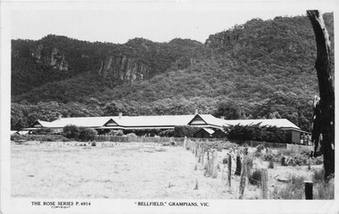 Halls Gap & Grampians Historical Society
Postcard, 03/04/1942
This photograph is the same one printed in 1925 soon after 'Bellfield' became a licenced hotel. Unfinished letter on reverse side indicates that at least 2 postcards were sent to the same recipient Reads as: "Belfield Hotel Grampians 3/4/42 Dear Mother, Well here we are once more amongst the Gum trees and believe me it is great to smell the fresh air once more after so long with the Rubber trees. We are right in the hills with towering mountains on the East and West and after the way the wind blew through gap last night, I would not be at all surprised if that were not the method by which the Gap were made. Several times last night we thought the roof would blow off and now I have cut pegs for the window I hope the rattle does not annoy us anymore. It took us until nearly five to get here last night but of course we did not find the time dragging on our hands. At Ballarat we made a rush for some lunch just got it back to the carriage when the waitress came round for"Photograph shows front of building with Wonderland Range behind handwritten letter on reverse side dated 03/4/42Rose Series P 4914accommodation, hotels, bellfield -
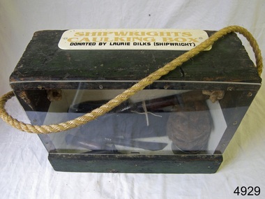 Flagstaff Hill Maritime Museum and Village
Equipment - Toolbox, Laurie Dilks, shipwright, Mid-to-late 20th century
Caulking is a process used by shipwrights and other tradespeople to seal the gaps and cracks in boats and ships, buildings and plumbing fittings. It prevents water, air and pests from entering the through the gaps. The shipwright’s caulking box and a display of shipwright's tools are connected to the maritime history of Victoria through their past owner, user and donor, Laurie Dilks. Laurie began his career as a shipwright in the mid-1900s, following in the wake of the skilled carpenters who have over many centuries used their craft to build and maintain marine vessels and their fittings. Laurie worked for Ports and Harbours, Melbourne, for over 50 years, beginning in the early 1960s. He and a fellow shipwright inscribed their names on a wheelhouse they built in 1965; the inscription was discovered many decades later during a repair of the plumbing. Many decades later Laurie worked on the Yarra River moving barges up and down the river and was fondly given the title ‘Riverboat Man’ His interest in maritime history led him to volunteer with the Maritime Trust of Australia’s project to restore and preserve the historic WWII 1942 Corvette, the minesweeper HMAS Castlemaine, which is a sister ship to the HMAS Warrnambool J202.The shipwright’s caulking box containing caulking tools is an example of the equipment used by shipwrights in the early to mid-20th centuries. This box is connected to the maritime history of Victoria through its past owner, user and donor, Laurie Dilks. Laurie began his career as a shipwright at Ports and Harbours in Melbourne in the mid-1900s, following in the wake of the skilled carpenters who have over many centuries used their craft to build and maintain marine vessels and their fittings.Shipwright's caulking box, green wooden exterior with green and cream interior. Box has a Perspex face. A rope handle, knotted on each end, extends from one side to the other. A white rectangular plaque with rounded corners is screwed to the top and has yellow and black printed text. The donor was shipwright Laurie Dilks.Printed on plaque "SHIPWRIGHTS / CAULKING BOX / DONATED BY LAURIE DILKS [SHIPWRIGHT]'"flagstaff hill, flagstaff hill maritime museum and village, warrnambool, maritime museum, maritime village, great ocean road, shipwreck coast, caulking tools, caulking equipment, caulking box, shipwright's tools, laurie kilks, ports and harbours -
 Melbourne Tram Museum
Sign - Adhesive label, Yarra Trams, c2003
Set of three Adhesive Label or Signs for use on trams - all of the type with an adhesive front type to enable it to placed on a window, printed on paper with a ruled back. .1 - "Door not in use" - printed on a vinyl based paper. .2 - "Your safety comes first. Please do not speak to the driver when the tram is moving" - white letters with the Yarra Trams banner underneath - printed on Avery paper. .3 - "Mind the gap when you step out" - printed on a vinyl based paper. -? Etamark signvinl paper. Three copies of each held, except, .2 only two.trams, tramways, yarra trams, signs, tramcars -
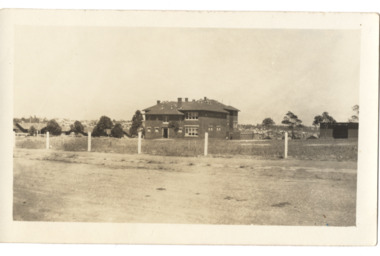 Kew Historical Society Inc
Postcard - Kew East State School No.3161, 35 Kitchener Street, c.1927
What is now Kew East Primary School was opened on its current site in Kitchener Street in 1923. The Kew East and Mont Albert Heritage Gap Study (August 2020) established that: 'Kew East Primary School No. 3136 is historically significant for the evidence it provides of an early phase in the development of Kew East which gathered momentum from the 1920s, as housing developed rapidly and the population increased in response to the extension of the High Street tram to Harp Road then Burke Road then improved tram connections between the area and the city.'A rare and early photograph of the school taken four years after its construction. Small, sepia coloured photographic positive of East Kew State School. The two storey red brick building was opened in 1923. This view, three years after its construction shows preliminary fencing and undeveloped playing grounds.schools -- kew east (vic.), government schools -- kew -- kew east, strathalbyn street -
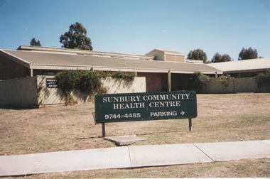 Sunbury Family History and Heritage Society Inc.
Photograph, Elwyn Davis, Former Sunbury Community Health Centre, March 2002
The first Sunbury Community Health Centre was built on the corner of Horne Street and Gap Road in a temporary building. As result of further funding in 1974, a permanent building was erected and opened in 1981 and operated from that site until 2000 when it was relocated into a larger and more modern building on the former Sunbury Primary School site in Macedon Street to accommodate Sunbury's expanding population and needs.It now operates under the name of Sunbury and Cobaw Community Health Centre. The old building was demolished and replaced with a fast-food outlet.A non-digital coloured photograph of the Sunbury Community Health Centre showing the notice board displayed in the front giving phone details and parking area.sunbury community health centre, health centres, gap road, horne street -
 Stawell Historical Society Inc
Photograph, ''Mokebilla" Station 1866
Mokebilla Station. Part of a collection of Photographs by Mr. O.G. Armstrong as commissioned by the Shire of Stawell for the Inter-colonial and Paris Exhibition in Melbourne in 1866. Charles Browning Hall was at the station for a short period in about 1840-41. Horatio Wils purchased Lexington from C.B. Hall in 1842. To this he added the stations of Larose and Mokebilla. Part of the property still remains along the Halls Gap Rd, by the bridge over the Mount William Creek. Note that the spelling has changed over the years and it is currently known as Mokepilly. Looking across water to Homestead and outbuildings behind large Gum Trees.stawell -
 Kiewa Valley Historical Society
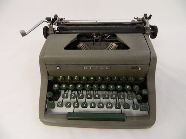
Typewriter - Manual, c1966
Typewriters pre dated computers. This typewriter was possibly used in an office or at home. It was used with an inked tape which may have been only black or had both red and black ink along it. Multiple copies of the material being typed were done using carbon paper inserted between sheets of paper. The original paper was easily identified.Used in the Kiewa Valley.Small grey metal typewriter with deep green key board with gold letters on top.The margin rod is marked in inches and it has keys for pounds, dollars and cents, inches and fractions. The loading of A4 paper is done manually. The keys that hit the paper are stainless steel. The keyboard slopes up to the top which is partially hollow with a gap that exposes the stainless steel keys. The cylinder is at the top and at the back with control knobs on each side. This typewriter has 2 sheets of paper with carbon paper between them to demonstrate how copies were made (but there isn't an inked tape in it so the copies aren't authentic)Centre front: "Royal" Letters of the alphabet on the keys. Centre bottom back: "Royal" and below on a plate: "Built in the British Empire / Protected by American / and Foreign Patents"office. typewriter. royal. carbon paper. decimal currency. office equipment. writing. -
 Halls Gap & Grampians Historical Society
Photograph - B/W, C 1918
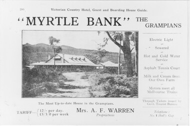
Information supplied with accommodation details Victorian Country Hotel, Guest and Boarding House Guide "Myrtle Bank" The Grampians Electric Light, Sewered, Hot and Cold Water Service, Asphalt, Tennis Court, Milk and Cream from our own farm, Motors meet all melbounre Trains, The Most Up-to-date house in the Grampians, Through Tickets issued by Govt. Tourist Bureau, Telephone : No. 1 Halls Gap Tariff: 12/ per day L 3/3/0 per week. Proprietress Mrs A. F WarrenGuest House and grounds with Tariff information and servicesQuality paper made in Germanyaccommodation, guesthouses, myrtlebank -
 Ballarat and District Irish Association
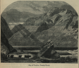
Image, Gap of Dunloe, County Kerry, c1864
The Gap of Dunloe is a narrow mountain pass between Macgillycuddy's Reeks (west) and Purple Mountain (east) in County Kerry, Ireland. It is about 11 km (6.8 mi) from north to south. Within it are five lakes: Coosaun Lough, Black Lake, Cushnavally Lake, Auger Lake, and Black Lough (north to south). These lakes are connected by the River Loe. Between the first two lakes is an old arch bridge called the 'Wishing Bridge' so named because it is said that wishes made while upon it are destined to come true. (http://en.wikipedia.org/wiki/Gap_of_Dunloe)Image of a mountain range in County Kerry, Ireland. Cattle feature in the foreground. ballarat irish, dunloe, gap of dunloe, county kerry -
 Kew Historical Society Inc
Photograph - Photographs, Former Baptist Church, Woodlands Avenue, Kew East, 2018, 2018
The former Baptist Church, at 8-12 Woodlands Avenue, Kew East, was nominated by the Society for protection as part of the Kew East Heritage Gap Study. W D Vaughan in his 'Kew's Civic History' (1960 writes that: "With the development of East Kew, local Baptists considered the establishment of a church was necessary. A block of land was purchased in Woodlands Avenue and the foundation stone of a new church was laid on August 8, 1931. A fine Sunday school has since been erected, and special emphasis has been given to providing activities for the young people of the church"Three colour photographs of the former Baptist Church in Woodlands Avenue, Kew East. The photographs are of the front and side of the clinker brick building. One of the photographs shows the foundation stone, laid by AH Lewis Esq, 8 August 1931.churches - kew (vic), baptist church - woodlands avenue - kew (vic) -
 Kiewa Valley Historical Society
Photos: Kiewa Hydro Electric Scheme x 12
K.H.E.S.Photos 4 coloured and 8 black and white with the Title printed below each one. 1. S.E.C.V. Telephone Switch Board (See also KVHS 0847) 2.West Kiewa Tunnel 3. Construction of Underground Power Station 4. Pretty Vally Camp 5.Outside Kiewa House, Bogong 6. S.E.C.V. Saucer (See also KVHS 0128) 7.Insulator Disk Struck by Lightning 8. S.E.C.V. Map of the Kiewa Hydro Scheme 9.Howman's Gap Camp 10.Tunnel Excavation Face 11. Mt Beauty Townhship 1948, looking north east 12. Mt Beauty Township - no labelkiewa hydro electric scheme photos -
 Halls Gap & Grampians Historical Society
Newspaper - Photocopy
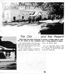
The article shows a photo of the original Hall's Gap Hall and the (then) new Hall, which was built in 1956. The copy has been scanned as two separate images (because it was too large for the scanner). the second image is stored under "Additional Images". HISTORY OF HALL'S GAP HALL: No village, no matter how small, could possibly survive without a public meeting place, and Hall's Gap was no exception, even in 1899-1900. Actually it was the locals of Stony Creek village, as Hall's Gap was known for a short time, who decided to hold a meeting to find out how much interest there was in building a town hall! They soon found out that support was overwhelming, as can be seen by the fact that 14 gentlemen nominated for a position on the committee of four! Several motions were moved at that meeting, mainly with reference to the materials to be used, for instance that no "wattle and daub", but rather slabs of bark and local bush logs be used. The walls were to be constructed of slabs, 6 feet long, 9 inches wide and two inches thick. Uprights were to be 9 feet high and at least 9 inches thick. Sheets of bark, all 32 of them, had to be 8 feet by 8 feet. Tenders for the building materials were called on 9 March 1899 and, 21 days later, McKeon Brothers won the right to supply all the material for the princely sum of 4 pounds 10 shillings. The size of the hall was to be 20 feet by 10 feet. The first hall served the community well for the next thirteen years, being regularly used as a place of entertainment and religious worship. The growing community soon realised the need for a larger venue, with better facilities, so once again the townsfolk rallied to raise funds for a new hall, realising their dream around 1913. In 1921 a schoolteacher was provided by the education department but as there was no school building she was expected to use the hall. Mainly lessons were held in the kitchen as it was much warmer than the hall itself, and it was not unusual for up to twenty children to be taught, ranging in age from 5 to 14 years. It was not until 1928 that an official school was built. 1955-56 were years of great excitement. The Progress Association was in charge of deciding the format for the new hall, and there were many rowdy meetings beforehand. Some members had much more vision than others, and to some the amount of money required seemed astronomical. Two hall committee members resigned over differences of opinion but amazingly it all came together in the end, albeit at a greater cost than had been anticipated. There is only one record of a grant being made for the building,1500 pounds, and it came for the Minister of Public Works. Estimated cost of the building was around 8,000 pounds, and when finally finished it was just slightly over, but bank charges and interest took it to well over 9,000 pounds. An electric light generator was included and lighting installed. The SEC electricity was connected in 1962.A copy of a newspaper article entitled 'The Old . . . and the Present!', which includes two photographs.buildings, halls -
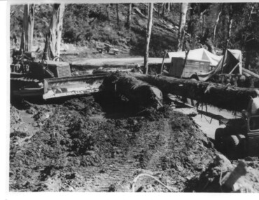
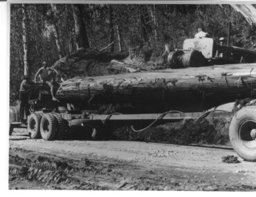 Kiewa Valley Historical Society
Photograph, logging at McKay Creek, Logging at McKay Creek, 1949/50
This photo was most likely taken at the site of the proposed McKay Creek Power Station. Excavation of this site was commenced in 1951 but an access road (a rough, narrow track) was put it in 1948 and widened in 1954. The State Electricity Commission would have milled logs from this area at their mill at Howman's Gap. The timber was used for building of housing and camps and provided a much needed resource as there was a general shortage of this commodity. The power station was relocated underground owing to repeated problems with landslides in the area. Restricted financial resources and the repositioning of the power station retarded construction activities and it was not completed until early 1961. An historical pictorial record of the type of machinery used in the 1950's - logging truck with bogie attached, the bull dozer and winch for hauling logs to the truck and note the lack of protective clothing!Black and white photograph showing a logging truck, bogie and bull dozer with winch for hauling the logs to the truck. Two men are on the truck, a driver on the bull dozer and a large log on the bogie. Hand written on the back of photo "Logging at McKay Creek".logging, mckay creek, timber, machinery -
 Federation University Historical Collection
Booklet, The Ballarat Historian: Journal of the Ballarat Historical Society - The History of Mt Clear High School, June 1983
The Mt Clear Technical High School was an amalgamation of several schools. The Ballarat Junior Technical School was started in 1913 to bridge the gap between primary schools and senior technical colleges at the old Dana Street National School under the administration of the School of Mines. The Ballarat Girls Technical School which was commenced in 1951 and the Girls High School which can be traced back to 1874, both had several incarnations before joining together. The Mt Clear Technical School separated from the School of Mines in January 1977 and was officially opened on 10th October 1981.Called 'A marriage of convenience', this 7 page, A4 booklet is stapled at the top left hand corner and is a photocopy of the vol.1, no.9 issue of The Ballarat Historian. It contains a history of the the schools in Ballarat which eventually merged and formed on the completion of the buildings in 1981, the Mt Clear Technical High School. It was written by J A Chisholm who was the Jnr. Vice-President of the Ballarat Historical Society. It was listed as Vol.1, No.9 as the Journal of the Ballarat Historical Society.ballarat historical society, journal of the ballarat historical society, the ballarat historian, j a chisholm, mount clear technical high school, mount clear high school, jack chisholm, j.a. chisholm, mt clear -
 Kiewa Valley Historical Society
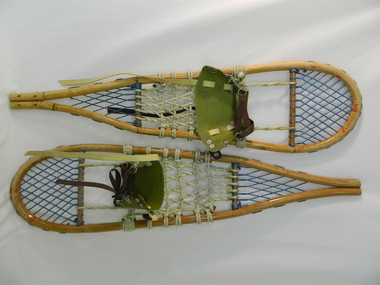
Snow Shoes
Snow shoes were used to move between places on the snow fields at Falls Creek and the Bogong High Plains especially during the construction of the Kiewa Hydro Scheme.Historical: Snow shoes were used on the Bogong High Plains during winter. The body is made of light wood 'bamboo' with a back and front wooden cross bar. Between the front cross bar and toe, blue nylon is tied to form diamonds 'lacing', similarly the back. Between the bars, in the middle is cream coloured rope tied to form a strong basket. A shoe harness made of olive green vinyl to which is clipped brown strong woven material tape with a circular steel loop through which the tape is threaded. There are 3 steel fasteners on 1 side and 2 on the other with a black plastic fastener. At the front between the cream and blue woven baskets there is a gap called the toe hole. The rope is attached either side of the toe hole to the front wooden bar.snow. falls creek. bogong high plains. transport. victorian alps. -
 Federation University Historical Collection
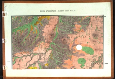
Map, Clunes, Mt Greenock, and Talbot Gold Fields, 1883, 1883
A geological plan of the Clunes, Mt Greenock, and Talbot Gold Fields in two parts. .1) This section of the map includes Talbot, Talbot water supply race, Mt Glasgow, Little Green Hill, Middle Hill, Mt Cameron, Ballarat Hill, Bakery Hill, Goodwoman Hill, Scandanavian Lead, Eglinton Swamp, McCallum's Creek, Tullaroop Creek, Dunach, Maryborough Railway, Middle Creek and includes many mines such as Rip Van Winkel, Union Extended, South Greenock, Nicholl's Freehold. .2) This section of the map includes McCallums, Clunes, Green Hill, Mt Beckworth, Mt Gap, Maryborough Reservoir, and includes mines such as Lothair, Bute, Clyde, Clunes Consols, London and Australian, Oriental,clunes, talbot, water supply, railway, geology -
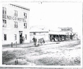 Bendigo Historical Society Inc.
Photograph - BLACK AND WHITE PHOTOGRAPH OF THE BENDIGO HOTEL
Black and white photograph of the Bendigo Hotel located in Bridge street. All nine windows are multi paned. There are two men and a boy standing in the doorway. Opposite the door stand and man and a boy near the cart belonging to Batchelder the Photographer. The man is wearing bowler hat. A corrugated iron fence spans the gap to the next building. The first building in the line is build using corrugated iron for the roof and walls. These retail establishments have a verandah along the footpath. A small group of retail staff are standing around watching the proceedings in the street. Two shops are name; J. Holdsworth and Glass & China warehouse. There may have been recent rain as the roadway appears to be puddled and quite damp.bendigo, history, buildings/streetscapes -
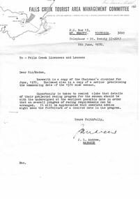 Falls Creek Historical Society
Document - Chairman's Circular June 1970 & Notice Proclaiming 1970 Snow Season Commencing Date
Bob (Herman) Hymans (a former member of the Royal Netherlands Navy) was born in Bloemendaal, Holland on 30th September 1922. During World War II he fought against the Japanese in the Dutch East Indies (now Indonesia) and was imprisoned in Changi and on the Burma Railway. After gaining qualifications as a Ski Instructor, Bob arrived in Falls Creek in July 1950. Working as an Instructor and Supervisor at Bogong Lodge, Bob decided his future was in accommodation. He was successful in negotiating an indenture for land from the State Electricity Commission (SEC). It took Bob two years to build his Grand Coeur Chalet but, tragically, it was burned down in August 1961. Bob also built the first Chairlift in Australia. This was a single chairlift and the structure was built from wooden electricity poles. He was constantly full of new ideas and proposals for the village. Bob Hymans died on 7th July 2007. This Collection of documents and letters tells the story of Bob's endeavours to develop Falls Creek into the ski village it is today.This item is significant because it documents actions taken by the Falls Creek Tourist Area Management Committee in their role overseeing the Tourist Area.A circular from the Management Committee prior to the 1970 season. The official season opening time was to be midday on 12th June 1970. Clubs were asked to register their race dates for the season. A wide range of information covered topics including: slope improvements; Village expansion with 20 new sites available: a new reception centre and the upgrade of the sewage treatment system to cater for 3,000 bed capacity. The CRB was widening the road between Howmans Gap and Falls Creek. Consideration was also being given to new tows and chairlift. Prices for tows and Ski School for the upcoming season were included. A detailed Financial Report was included. An expression of thanks and best wishes was extended to Jack Andrew on his retirement.falls creek tourist area management committee, falls creek administration, bob hymans -
 Kiewa Valley Historical Society
Photograph, logging at McKay Creek, Logging at McKay Creek, c1950's
This photograph was probably taken at the site of McKay Creek Power Station. Excavation of this site did not commence until 1951 but road access(a narrow track) was provided in 1948 and widened in 1954. The logs would have been milled for timber at the State Electricity Commission's mill at Howman's Gap and thus provided a much needed source of timber for construction of camps and houses as there was a general of shortage of this commodity. Because of trouble with landslides in this area, a decision was made to place the machine hall of the power station underground instead of on the surface. Restricted financial resources and the repositioning of the power station retarded construction activities and it was not completed until early 1961.. An excellent pictorial record of the general working conditions, type of machinery and vehicles in use in the 1950/s.Black and white photograph showing logging equipment, fallen logs.Handwritten on the back of the photograph "Logging at McKay Creek)logging, mckay creek, timber, machinery -
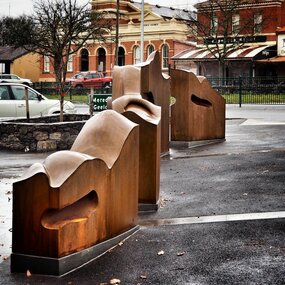 City of Ballarat
Artwork, other - Public Artwork, Cliff Burtt, Buninyong Bivium, 2016
Buninyong Bivium (2016) by Cliff Burtt engages with the geography and history of the Buninyong region in both pre and post settlement. The town of Buninyong is dominated by the profiles of Mt Helen and the extinct volcano Mt. Buninyong. Traditional land of the Wadawurrung people, today the area remains a significant site for the culture of indigenous people and their connection to the land. The profile of this sculpture is based on topographical mapping of the area, depicting sections of the landscape. The gaps between the elements of the work can be viewed as representations of the shafts sunk into the earth by the early gold miners and compound curves on the upper surfaces are mirroring the topography of the area, while cut-aways in the sides are suggestive of rock strata.The artwork is of aesthetic and social significance to the people of BallaratCorten steel sculpture made of five unique sculptural pieces secured to at concreate base at pavement levelbuninyong, cliff burtt, sculpture, public art, mining, ballarat -
 Kiewa Valley Historical Society
Photograph - Folder of Photographs – Photocopied set of black and white photographs (pages 49 -58) from the display folder put together by KVHS to document life on the Kiewa Valley Hydro-electric Scheme
Although the Kiewa Hydro-Electric Scheme was first proposed in 1911, construction did not commence until 1938. As part of the push to cut electricity costs and diversify supply, the Victorian Government (circa 1930) initiated the conversion from primarily brown coal supply to hydro – electricity. Field investigations during the 1940’s resulted in a new proposal for a scheme that had more than double the capacity of the 1938 scheme. The Kiewa Hydroelectric Scheme became the largest scheme of its kind in the State Of Victoria and the second largest scheme in Australia. The number of personnel involved in the planning and construction of the scheme increased dramatically. During the late 1940’s, most activity centred around the construction of the West Kiewa Power Station, Rocky Valley Reservoir, McKay Creek Power Station and the Bogong Creek Aqueduct.A common thread across all the larger hydro scheme constructions was the need for workers, both qualified and unqualified who came from around the world seeking a new life for themselves and their families. New accommodation and facilities were required for the army of workers engaged in construction in often remote and wild areas. The SEC had a high demand for timber, and set up the first of a number of sawmills at Bogong Creek in 1939 and set up the first hardwood logging in the headwaters of the Kiewa River. These new ‘towns’ such as Mt Beauty and Bogong, survived, serving the needs of operational personnel and their families, and expanding with growth of new industries. Mount Beauty, and to a lesser extent Bogong, are among these places. Large A3 size spiral bound display folder containing photocopied black and white photographs of various aspects of the early days of the Kiewa Valley Hydro-electric scheme including equipment, various work sites and photographs of workers and their families. 1-Workmen working inside one of the tunnels. 2-Workman drilling in West Kiewa Tunnel 3-Junction Dam wall construction 4&5-2B&W photographs Kiewa House residents ready to go to a ball in Mt Beauty 6-Workmen warming up in front of a fire at No 1 bench 7-Workmen being hauled in at No 4 P.S Shaft 8-No 4 Power Station – Drilling 9-Workmen eating a hot meal in the tunnel. 10-2 photographs (a)Pretty Valley camp showing workman’s huts and construction materials & (b)Worker in Langford Gap Basalt Hill Tunnel face 11-Tunnel entrance (unlabelled) with rail tracks in foreground 12- Workmen drilling at No 1 Head race tunnel-Drilling face 13- No 1 Power Station 14-Workmen at the entrance to one of the SECV tunnels under construction 1-SECV number at bottom of picture Half obscured possibly K8461 Page number 53 2-In West Kiewa Tunnel Page number 54 3- Construction of Junction Dam wall – approximately 1941 Page number 55 4&5- Residents of Kiewa House at Bogong ready to go to the ball at Mt Beauty-1946. Handwritten on a copy of the photo on opposite page Mrs Lorna Crosset filled out the names *Dad was Des Crossett – his daughter is Gael Petcopoulis Greta engaged to John broke it off. Charlie, Rosalind, Bill, Priscilla, Max Lawrence-Dad’s Boss, Mary & Max married, Mary, Kay, Gwen McPherson Mum’s boss, John McCluskey (c) At No. 5 Bench Page number 56 6- STATE ELECTRICITY COMMISSION OF VICTORIA Date: 27.2.51 Time:2.15pm No K6373 Kiewa Hydro Electric Works No. 4 P.S. Shaft – Haulage of men in buckets (b) As above Handwritten at top of photo Appendix 4 page number 57 7- STATE ELECTRICITY COMMISSION OF VICTORIA Date: 6.6.52 Time:… No K7122 Kiewa Hydro Electric Works No. 4 POWER STATION – DRILLING page number 58 8-No markings page number 59 9-(a)Handwritten under photograph Approx. 1948/49 (b) STATE ELECTRICITY COMMISSION OF VICTORIA Date: 28.10.54 Time:.. No K7860 Kiewa Hydro Electric Works LANGFORD GAP BASALT HILL TUNNEL FACE Page number 49 10-(a) No markings 11- STATE ELECTRICITY COMMISSION OF VICTORIA Date: 20.3.52 Time: No K6979 Kiewa Hydro Electric Works No. 1 HEAD RACE TUNNEL – DRILLING FACE (E.E.E. CONTRACT) ‘The Frenchies’ (E.E.E) as they were affectionately known Page number 50 12-31.5.56 No. 1 Power Station Aggregate Stock Piles. Page number 51 13&14-No markings Page number 52 secv; kiewa hydro electric scheme; bogong; mt beauty; construction area