Showing 7116 items matching "snowy-river"
-
 Eltham District Historical Society Inc
Photograph, "As we are" Community Banner Project, c.Oct. 1986
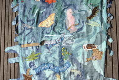
River of Life and Hiroshima Day Banners The River of Life and Hiroshima Day banners were specific peace projects initiated by the CAO and taken up by Eltham Living & Learning Centre and funded by the Victorian Peace Secretariat for IYP. The project was transferred from the Centre to Tracey as part of her artist in the community portfolio. Tracey, as CAO, employed Jacky Talbot, who was not familiar with Eltham but was an experienced community arts worker personally interested in textiles and peace. The project was publicised and a peace banner group formed. Only two of the women knew each other. They had come together from a need to do something for peace, rather than to learn about textiles. Jacky Talbot shared Elizabeth Savage's approach to the banner. She was not 'a peace-expert' and did not want to be seen as such by the group. Like Elizabeth Savage she wanted to encourage an expression of peace as it was perceived by the group. Jacky showed slides of peace images and peace banners. Textile workshops were interspersed with discussions about peace, one of which was led by a local People for Nuclear Disarmament member. The idea for the banner occurred during one of these discussions. One of the women began to talk about feeling like a drop of water lost in the river of life - yet rivers were made of countless droplets which, when joined together, became the powerful force of the river. This group quickly established a commitment, not only to peace, but to the group itself, and this has continued beyond the project. The women, as is the case with many of the groups in the Banner Project, were really surprised at their increasing textile skills and self-confidence. But they were more concerned with their commitment to peace. Each is continuing to find ways in which she can continue to work for peace, and activities are undertaken on a group basis as well. The decision to participate in the group based activities is up to each woman as the time arises. The banner and some members of the group have now participated in the Peace Boogie at the World Trade Centre, the Peace Arts Conference organised by Art Action for Peace, Melbourne City Council's Peace Vigil weekend, Women's Precious Things for Peace Day exhibition and the banner was ' hung at the Footscray Community Arts Centre when the other textile peace mural Jacky co-ordinated was opened. One woman wrote a poem about the project and peace; others have sent telegrams and letters to politicians about peace. A great deal of information about peace and other activities, articles, books, media programs were circulated amongst the group. The Hiroshima Day Banner was made by Jacky Talbot as part of the project. The women wanted to do something for Hiroshima Day and suggested that a workshop be set aside to make a banner. The artist was concerned about the remaining time scheduled for the project and spent several days "whipping" up the banner herself. For the artist this banner was to prove quite significant. The women hung it at the Community Notice Board on Hiroshima Day and were photographed by the local newspaper publicising the group and drawing wider community attention to the remembrance of the day. Although no new members joined the group from this activity, the artist felt that she was more fully accepted by the group afterwards. This banner has initiated a small group of women committed to peace. The artist has also continued to liaise and meet with the women as time permits. Future group plans include: making kimonos to wear when carrying the banner, participating in the Palm Sunday March, an observance of Hiroshima Day activity, which is yet to be decided, establishing contact with a sister-town in USA and USSR and supporting Eltham Council's stance as a Nuclear Free Zone. (Source: The banner habits of the Eltham tribes : Eltham Shire "as we are" Community Banner Project report / by Jacky Talbot, Shire of Eltham, Feb. 1987, pp43-46)35mm colour positive transparency (1 of 2) Mount - Kodak KodachromeProcess Date OCT 86Mbanner project, community banner project, tracey naughton, eltham living and learning centre, eltham peace banner, jacky talbot, river of life banner -
 Eltham District Historical Society Inc
Photograph, "As we are" Community Banner Project, c.Oct. 1986
River of Life and Hiroshima Day Banners The River of Life and Hiroshima Day banners were specific peace projects initiated by the CAO and taken up by Eltham Living & Learning Centre and funded by the Victorian Peace Secretariat for IYP. The project was transferred from the Centre to Tracey as part of her artist in the community portfolio. Tracey, as CAO, employed Jacky Talbot, who was not familiar with Eltham but was an experienced community arts worker personally interested in textiles and peace. The project was publicised and a peace banner group formed. Only two of the women knew each other. They had come together from a need to do something for peace, rather than to learn about textiles. Jacky Talbot shared Elizabeth Savage's approach to the banner. She was not 'a peace-expert' and did not want to be seen as such by the group. Like Elizabeth Savage she wanted to encourage an expression of peace as it was perceived by the group. Jacky showed slides of peace images and peace banners. Textile workshops were interspersed with discussions about peace, one of which was led by a local People for Nuclear Disarmament member. The idea for the banner occurred during one of these discussions. One of the women began to talk about feeling like a drop of water lost in the river of life - yet rivers were made of countless droplets which, when joined together, became the powerful force of the river. This group quickly established a commitment, not only to peace, but to the group itself, and this has continued beyond the project. The women, as is the case with many of the groups in the Banner Project, were really surprised at their increasing textile skills and self-confidence. But they were more concerned with their commitment to peace. Each is continuing to find ways in which she can continue to work for peace, and activities are undertaken on a group basis as well. The decision to participate in the group based activities is up to each woman as the time arises. The banner and some members of the group have now participated in the Peace Boogie at the World Trade Centre, the Peace Arts Conference organised by Art Action for Peace, Melbourne City Council's Peace Vigil weekend, Women's Precious Things for Peace Day exhibition and the banner was ' hung at the Footscray Community Arts Centre when the other textile peace mural Jacky co-ordinated was opened. One woman wrote a poem about the project and peace; others have sent telegrams and letters to politicians about peace. A great deal of information about peace and other activities, articles, books, media programs were circulated amongst the group. The Hiroshima Day Banner was made by Jacky Talbot as part of the project. The women wanted to do something for Hiroshima Day and suggested that a workshop be set aside to make a banner. The artist was concerned about the remaining time scheduled for the project and spent several days "whipping" up the banner herself. For the artist this banner was to prove quite significant. The women hung it at the Community Notice Board on Hiroshima Day and were photographed by the local newspaper publicising the group and drawing wider community attention to the remembrance of the day. Although no new members joined the group from this activity, the artist felt that she was more fully accepted by the group afterwards. This banner has initiated a small group of women committed to peace. The artist has also continued to liaise and meet with the women as time permits. Future group plans include: making kimonos to wear when carrying the banner, participating in the Palm Sunday March, an observance of Hiroshima Day activity, which is yet to be decided, establishing contact with a sister-town in USA and USSR and supporting Eltham Council's stance as a Nuclear Free Zone. (Source: The banner habits of the Eltham tribes : Eltham Shire "as we are" Community Banner Project report / by Jacky Talbot, Shire of Eltham, Feb. 1987, pp43-46)35mm colour positive transparency Mount - Black and Whitebanner project, community banner project, tracey naughton, eltham living and learning centre, eltham peace banner, jacky talbot, river of life banner -
 Warrnambool and District Historical Society Inc.
Album - Album, photograph Warrnambool Horn Esq
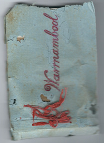
This album contains photographs of a family, (the Horns of ‘Wildwood’, Warrnambool) and other photographs of Warrnambool – the foreshore, the Soldiers’ Memorial, the Breakwater, the Hopkins River, Liebig and Timor Streets etc. It has been made by a member of the Horn family and given as a Christmas present to other members of the family. Charles James Horn came to Australia in 1881and was a tutor to the Barber family of ‘Staywood Park’, Wangoom. He and his wife Emma then worked a property at Cudgee before settling in Warrnambool at ‘Wildwood’ in North Warrnambool. One of their sons, Charles Bernard Horn married Margaret Cairns in 1916 but died in 1927. Another son, Leslie, was killed in World War One. This little album is of great interest because it contains photographs of the Horn family and other photographs of views in Warrnambool. It is therefore of considerable historical interest and will be very useful to researchers. As it is a handmade item it is also of interest because it is an example of the sort of homemade items made as presents at a time (the late 1920s) when finances for something more expensive may not have been available. These are two items which are believed to be linked. One is an envelope marked ‘C.J. Horn, Wildwood, Warrnambool’ and the other is a blue-covered homemade album of photographs bound with red wool. The front cover has ‘Warrnambool’ written in red ink and the back of the front cover is stamped ‘Ralph Barnes, Chemist, Warrnambool’. There are 22 sepia-coloured photographs of a family (the Horns) and other views of Warrnambool. All have a label on the back. The back page of the cover has an advertisement for ‘Seltona’ self-toning paper.‘Warrnambool’ ‘7 sheets glossy Seltona’ collodion self-toning paper containing gold, Sole Manufacturers, Wellington and Ward, Elstree, Herts.’ ‘From us both to you both, Wishing you a Happy Christmas and a Glad New Year’. warrnambool, horn family, charles james horn, staywood park, wildwood warrnambool -
 Warrnambool and District Historical Society Inc.
Badges, A.W.Patrick, Lyndoch, 1950s
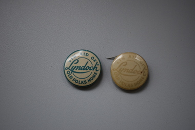
These badges were produced in the 1950s to raise funds for the Lyndoch Old Folks Home in Warrnambool. This aged care facility at the mouth of the Hopkins River was opened in 1952 when the property known as Lyndoch was purchased. Lyndoch had been established in the 1880s by the Melbourne businessman George Rolfe who bought up a considerable amount of land in the Warrnambool district in the late 19th century. After George Rolfe died his step-daughter, Florence Lake built the bungalow known as Lyndoch and this building was the basis for the development of the property into an aged care facility. Today the facility has been considerably expanded and is known as Lyndoch Living. These badges are retained as mementoes of the type of fund-raising ventures conducted in the 1950s to raise funds for local charities in Warrnambool – in this case ‘Lyndoch’ Old Folks Home..1 A metal badge with green lettering on a cream-coloured background. The rusted back has a metal clip and the name of the maker is printed around the edge of the badge. .2 As above except that the lettering is very faded and the clip at the back does not work. In aid of “Lyndoch” Old Folks Home A.W.Patrick N. Fitzroy Vict. lyndoch living aged care facility, history of warrnambool -
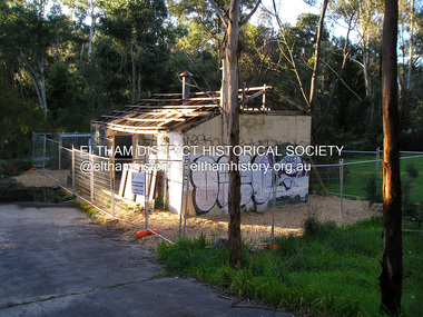 Eltham District Historical Society Inc
Photograph, Fay Bridge, Warrandyte cool store, 9 September 2019
Remains of the old Warrandyte Dairy — Originally constructed to store milk for delivery from Mapleoak Dairies, delivered by the Bellinger family, up until the early 1970s. The Warrandyte Dairy closed in 1987 before the land and building was purchased by Melbourne Water in 1988 to reduce flood risk to the community and preserve riverside land from development on the site which sits on the Yarra River flood plain. In 2017, through a partnership with Manningham City Council, Warrandyte Historical Society and the Warrandyte Community Association, Melbourne Water renovated the 73-year-old site and installed interpretive signs detailing its history for the community.2019-09-09, fay bridge collection, warrandyte cool store, warrandyte dairy -
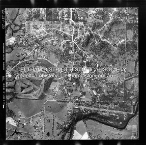
 Eltham District Historical Society Inc
Photograph - Aerial Photograph, Landata, Lower Plenty, Feb. 1956
Centred on present day 217 Old Eltham Road, Lower Plenty bounded by Pitt Street to north, Yarra River to south, Main Road to east and Bonds Road to west. Historic Aerial Imagery Source: Landata.vic.gov.au Aerial Photo Details: Project No :250 Project : MELBOURNE OUTER SUBURBS PROJECT Run : 17 Frame : 116 Date : 02/1956 Film Type : B/W Camera : EAG9 Flying Height : 10000 Scale : 12000 Film Number : 1176 GDA2020 : 37°43'58"S, 145°07'49"E MGA2020 : 335237, 5822186 (55) Melways : 21 E10 (ed. 42)aerial photo, 1956-02, neil webster collection, eltham, main road, bonds road, elham, lower plenty, melway 21e10, pitt street, yarra river -
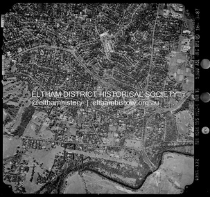
 Eltham District Historical Society Inc
Photograph - Aerial Photograph, Landata, Eltham, Vic, Apr. 1963
Centred on present day Griffith Park Road, Eltham bounded by Mount Pleasant Road to north, Yarra River and Templestowe to south, Main Road at Reynolds Road to east and Falkiner Street to west. Historic Aerial Imagery Source: Landata.vic.gov.au Aerial Photo Details: Project No :486 Project : MELBOURNE (1963) PROJECT Run : 7 Frame : 233 Date : 04/1963 Film Type : B/W Camera : RC8 Flying Height : 5100 Scale : 9600 Film Number : 1805 GDA2020 : 37°44'04"S, 145°09'10"E MGA2020 : 337237, 5822053 (55) Melways : 22 A10 (ed. 42)aerial photo, neil webster collection, 1963-04, eltham, falkiner street, griffith park road, melway 22a10, mount pleasant road, reynolds road, templestowe, yarra river -
 Eltham District Historical Society Inc
Photograph - Aerial Photograph, Landata, Eltham, Vic, Apr. 1972
Centred on present day Dalton Street at Mount Pleasant Road, Eltham bounded by Arthur Street to north, Yarra River and Kent Hughes Road to south, Eucalyptus Road to east and Susan Street to west. Historic Aerial Imagery Source: Landata.vic.gov.au Aerial Photo Details: Project No :985 Project : MELBOURNE 1972 Run : 28 Frame : 208 Date : 04/1972 Film Type : B/W Camera : RC10 Flying Height : 5700 Scale : 9600 Film Number : 2635 GDA2020 : 37°43'29"S, 145°08'54"E MGA2020 : 336816, 5823118 (55) Melways : 21 J8 (ed. 42)aerial photo, neil webster collection, 1972-04, eltham, arthur street, dalton street, eucalyptus road, kent hughes road, melway 21j8, mount pleasant road, susan street, yarra river -
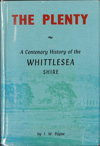 Eltham District Historical Society Inc
Book, J. W. Payne, The Plenty: A Centenary History of the Whittlesea Shire, 1975
This book traces the one hundered years of the development of the Shire of Whittlesea, from the discovery by Hume and Hovell in 1824 to the time of the centenary in 1975. The intervening years saw the settlement of Vandemonians, Sydney-siders, English, Scots, Irish and Germans, Black Thursday, the building of the Yan Yean Reservoir, the Plenty River flour millls, the timber industry, fruit-growing and export and vineyards. Personalities and pubs, subdivisions, stories of the Findon Hunt Club and various Shires including Epping. History of education and transiton from rural to urban in the south of the Shire. The work is illustrated with maps and photographs. The Shire is now the City of Whittlesea and is an immediate neighbour to the north of the Shire of Nillumbik. shire of whittlesea -
 Bendigo Military Museum
Album - ALBUM, PHOTOGRAPH WW2
Cyril Raymond Scarborough PRE WW2 served in 38th BN Militia 1921-1938. From 1939 h tried to join the RAAF as “Carpenter General” his trade, rejected several times no position available. Finally accepted on 26.2.42 age 37 plus years No 51255. There are no embarkation dates recorded but on 1.6.44 repairing a bridge over the Raku River Aitape during enemy action and occupation he crushed his right foot and was hospitalised in New Guinea returning to duty on 16.10.44. At the end he enlisted in the “Interim Army” from 24.7.46 and went on to serve in BCOF Japan. He was discharged with the rank of CPL on 31.5.48 Photo album, heavy cardboards cover with red fabric covering, held together by cloth fabric, front has a Japanese layered depiction of a person, has 48 pages of photos taken at Australia, Morotai , Labuan and Japan. Inside front cover “ CYRIL R. Scarborough, 5 ACS RAAF/ WAKUNI Japan” Page 3 “ on tour 21.1.46 to 26.6.47 Australia, Ambou, Morotai,Labuan, Japan” , albums, photographs, ww2, japan -
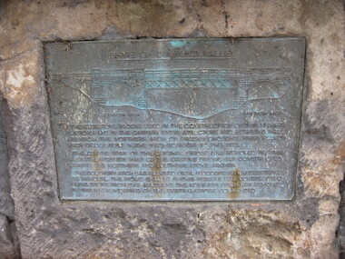 Greensborough Historical Society
Photograph - Digital image, Dennis Ward, Bridge Plaque - Pioneer Park Greensborough, 27/03/2010
Plaque at Pioneer Reserve Greensborough: "Shire of Diamond Valley. The bluestones used in the construction of this viewing platform and in the carpark entry structure and retaining wall are from the northern arch of Greensborough's first Plenty River Bridge built in the 1860s adjacent to this site. The centre span of the original bridge was removed in 1865 when the western half of the existing bridge was constructed leaving the northern and southern stone arches. The southern arch was retained until floods in 1874 necessitated its removal. The picnic shelter in this reserve was constructed using stone from this abutment. The northern arch was removed in 1983 when widening of the existing bridge commenced."Digital copy of colour photograph.plenty river, pioneer reserve greensborough -
 City of Moorabbin Historical Society (Operating the Box Cottage Museum)
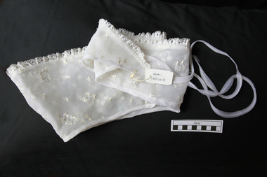
Clothing - Clothing, lady's embossed nylon organza collar, c1950
Organza is a thin, plain weave, sheer fabric traditionally made from silk. Many modern organzas are woven with synthetic filament fibres such as polyester or nylon. Silk organza is woven by a number of mills along the Yangtze River and in the province of Zhejiang in China. A coarser silk organza is woven in the Bangalore area of India. Deluxe silk organzas are woven in France and Italy. Organza is used for bridal wear and eveningwear. In the interiors market it is used for effects in bedrooms and between rooms. Double-width organzas in viscose and acetate are used as sheer curtains. Nylon organza was very popular as the new fashion material in the 1950’sA lady's collar white embossed nylon organza with machine lace edge. C1950clothing, nylon, organza, dressmaking, moorabbin, bentleigh, cheltenham, fashion -
 Eltham District Historical Society Inc
Photograph, 1934 Floods at Eltham
Published in the Diamond Creek Basin Study, 1980 and identified at Diamond Creek, locality not identified, 1934. The location is actually looking south across the Diamond Creek towards Falkiner Street, beside the Main Road bridge at Eltham South from what is now part of Wingrove Park opposite Antoinette Boulevard. The bridge railing is just visible to the left of image. The large leaning Manna Gum beside the bridge still stands in 2021 alongside the Diamond Creek trail. In 1934 extensive flooding of the Yarra River and Diamond Creek set new records for flood plain level (Eltham Chronology, EDHS)Black and white photographCopied by Hugh Fisher, Photographer, 6 York Street Eltham A1678B Floods- Eltham - 1934floods, yarra river, eltham, flooding, diamond creek, flood -
 Federation University Historical Collection
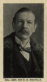
Photograph (black & White), Major-General Sir Henry Edward Colville - South Africa
Henry Colville was educated at Eton and then entered the Grenadier Guards in 1870. He was appointed Aide-de-Camp to General the Honorable Sir Leicester Smyth, commanding the forces in South Africa in 1880. Colville had expeditions and was mentioned in despatches on numerous occasions. In 1893 he succeeded Sir Gerald Portal as Commissioner for Uganda, received the Central Africa Medal, made Knight Commander of the Order of St Micael and St George and received the second class Order of the Brilliant Star of Zanzibar. He served in the Second Boer War and during the early part he commanded the Guards Brigade, including during the Battle of Modder River in 1899.Individual image from photographed poster of tobacco and cigarette cards.henry colville, eton, greadier guards, aide-de-camp, south africa, commissioner for uganda, central africa medal, knight commander of the order of st michael and st george, order of the brilliant star of zanzibar, battle of modder river, second boer war -
 Kew Historical Society Inc
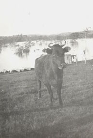
Photograph, Cattle in North Kew floods, 1934
The year 1934 witnessed the greatest flooding of the Yarra River since settlement. This work forms part of the collection assembled by the historian Dorothy Rogers, that was donated to the Kew Historical Society by her son John Rogers in 2015. The manuscripts, photographs, maps, and documents were sourced by her from both family and local collections or produced as references for her print publications. Many were directly used by Rogers in writing ‘Lovely Old Homes of Kew’ (1961) and 'A History of Kew' (1973), or the numerous articles on local history that she produced for suburban newspapers. Most of the photographs in the collection include detailed annotations in her hand. The Rogers Collection provides a comprehensive insight into the working habits of a historian in the 1960s and 1970s. Together it forms the largest privately-donated collection within the archives of the Kew Historical Society.Photograph of floodwaters encroaching on farm land in North Kew in the flood of 1934.Nth. Kew. 1934 Floodsfloods (melbourne) 1934, dorothy rogers -
 Kew Historical Society Inc
Photograph - Willsmere [Kew] Billabong, 1993
Willsmere Park is bounded by the the Yarra River, Green Acres Golf Club, Willow Grove and the Eastern Freeway. The land on which the park is now situated was bought by Thomas Wills at the Crown Land Sales of 1846 (Section 56). From the 1840s to the 1940s it was intensively farmed. The park is dominated by very large playing fields, while planting to the southern boundary was undertaken when the Eastern Freeway was built. It is only along the banks of the Yarra that there is any remnant native vegetation. Willsmere Park is of significance as an area of open land that remains from the flood plain that once dominated northern Kew. (Source: Kew Conservation Study, 1988)Original colour small format polaroid photograph of the 'Kew Billabong' in the Willsmere Park, taken on 16 September 1993."Willsmere Billabong 16.9.93"kew billabong, willsmere park, yarra river -- billabongs -
 Kew Historical Society Inc
Photograph - Flooding in the Willsmere Park, 1993
Willsmere Park is bounded by the the Yarra River, Green Acres Golf Club, Willow Grove and the Eastern Freeway. The land on which the park is now situated was bought by Thomas Wills at the Crown Land Sales of 1846 (Section 56). From the 1840s to the 1940s it was intensively farmed. The park is dominated by very large playing fields, while planting to the southern boundary was undertaken when the Eastern Freeway was built. It is only along the banks of the Yarra that there is any remnant native vegetation. Willsmere Park is of significance as an area of open land that remains from the flood plain that once dominated northern Kew. (Source: Kew Conservation Study, 1988)Original colour small format polaroid photograph of flooding in the Willsmere Park, taken on 16 September 1993."Flooding of shared path from Willsmere Billabong 16.9.93"willsmere park, yarra river -- floods -- kew (vic.), kew billabong -
 Kew Historical Society Inc
Photograph - Flooding in the Willsmere Park, 1993
Willsmere Park is bounded by the the Yarra River, Green Acres Golf Club, Willow Grove and the Eastern Freeway. The land on which the park is now situated was bought by Thomas Wills at the Crown Land Sales of 1846 (Section 56). From the 1840s to the 1940s it was intensively farmed. The park is dominated by very large playing fields, while planting to the southern boundary was undertaken when the Eastern Freeway was built. It is only along the banks of the Yarra that there is any remnant native vegetation. Willsmere Park is of significance as an area of open land that remains from the flood plain that once dominated northern Kew. (Source: Kew Conservation Study, 1988)Original colour small format polaroid photograph of flooding in the Willsmere Park, taken on 16 September 1993."Flooding of Willsmere Park from Yarra 16.9.93"willsmere park, yarra river -- floods -- kew (vic.) -
 Kew Historical Society Inc
Photograph - Flooding of Willsmere Park from Yarra, 1993
Willsmere Park is bounded by the the Yarra River, Green Acres Golf Club, Willow Grove and the Eastern Freeway. The land on which the park is now situated was bought by Thomas Wills at the Crown Land Sales of 1846 (Section 56). From the 1840s to the 1940s it was intensively farmed. The park is dominated by very large playing fields, while planting to the southern boundary was undertaken when the Eastern Freeway was built. It is only along the banks of the Yarra that there is any remnant native vegetation. Willsmere Park is of significance as an area of open land that remains from the flood plain that once dominated northern Kew. (Source: Kew Conservation Study, 1988)Original colour small format polaroid photograph of flooding in Willsmere Park resulting from heavy rain on 15 September 1993."Flooding of Willsmere Park from Yarra 16.9.93"yarra river -- floods -- kew (vic.), willsmere park -
 Kew Historical Society Inc
Photograph - Willsmere [Kew] Billabong, 1993
Willsmere Park is bounded by the the Yarra River, Green Acres Golf Club, Willow Grove and the Eastern Freeway. The land on which the park is now situated was bought by Thomas Wills at the Crown Land Sales of 1846 (Section 56). From the 1840s to the 1940s it was intensively farmed. The park is dominated by very large playing fields, while planting to the southern boundary was undertaken when the Eastern Freeway was built. It is only along the banks of the Yarra that there is any remnant native vegetation. Willsmere Park is of significance as an area of open land that remains from the flood plain that once dominated northern Kew. (Source: Kew Conservation Study, 1988)Original colour small format polaroid photograph of Willsmere [Kew] Billabong on September 1993."Willsmere Billabong 16.9.93"yarra river -- floods -- kew (vic.), willsmere park -
 Federation University Art Collection
Work on paper - Printmaking, Returning Ducks, 1999
Yang Deliang was from the Jinshan Peasant Painting Academy where Chinese folk art of southeastern Yangtze River area of Shanghai is undertaken. The paintings integrate the folk arts of printing and dyeing, embroidery, paper cutting, wood carving, and cook stove painting, and depict the peasant's colorful customs and daily life. This style of folk art was born in 1972, under the guidance of a professional painter Wu Tongzhang. Jinshan Peasant Painting made its international debut in the Expo 1980 in Brussels, Belgium. This item is part of the Federation University Art Collection. The Art Collection features over 1000 works and was listed as a 'Ballarat Treasure' in 2007.Framed silkcreen An artist's 'chop' is evident on the lower right cornerart, artwork, yang deliang, chinese, silkscreen, jinshan peasant painting academy, j -
 Bacchus Marsh & District Historical Society
Plaque, Shire of Bacchus Marsh Coat of Arms
Coat of Arms used by the Shire of Bacchus Marsh in the 1980s and 1990s. A coat of arms has been in use in the Shire at least from the early 20th century. This earlier coat of arms described in 1910 featured two cows standing on two bales of lucerne hay, with lucerne fields and fruit trees and rolling hills all round a central valley with two rivers running through it. This early coat of arms was superseded by the slightly different design shown here. When this change took place is not known. When the Bacchus Marsh Shire amalgamated with other Shires to form Moorabool Shire in 1994 this design was superseded.The plaque showing the Bacchus Marsh Shire Coat of Arms is in near perfect condition and as such is an excellent example of the physical symbols used to demonstrate the presence of local government in the Bacchus Marsh region. The images on the coat of arms also depict key economic and agricultural activities in the region which provides historical information about the region in a visual and artistic way.Painted cast bronze plaque with inscription on outer white band in black capital lettering: SHIRE OF BACCHUS MARSH. Inner circle painted blue with shield and decorative branches bearing yellow leaves on either side. Shield quartered and surmounted by stylised sunrise. In four quarters, representations of significant local primary and secondary industries. SHIRE OF BACCHUS MARSH.coats of arms, shire of bacchus marsh -
 Kew Historical Society Inc
Painting, W Nicholls Anderson, Adeney Avenue, Kew, 1906
William Nichols Anderson (1873-1927) was an Australian painter, one of whose works from the 1906 series River + Rail is in the Kew Historical Society’s art collection (donated 1984). A separate archive file contains correspondence, biographical information (written by his niece), and locations in Kew where he lived. Much of the correspondence between the Society and the City of Kew relates to the painting and its location in the Mayor’s Room at the Kew Civic Offices, Charles Street, where it was on loan from the Society. Lucy M (Jean) Hornby, the artist’s niece and the donor of the painting was a resident of 5 and 20 Queens Street, Kew (Vic). Australian ImpressionismGift of Lucy Hornby, 1984Framed oil on canvas by W. Nicholls Anderson of Park Street, Kew (now Adeney Avenue) looking uphill in a southerly direction towards Cotham Road. The painting is dated to 1906. The two storey house at left was known as 'Eborensis'. The house is still extant on the corner of Adeney Avenue and Parkhill Road. On sticker on back of frame - Adeney Ave./1913/ £3.3.0/ 13th Annual/ Exhib. V.A.S [Victorian Artists Society]/1911 Aust Art Exhib/the Guidlhall/Swanston st Melb./ Adeney's Paddock/ Kew. £3.0.0.artists - kew - victoria - australia, victorian artists society, william nicholls anderson (1873-1927), adeney avenue kew, australian art exhibition 1911, victorian artists' society, w. nicholls anderson -
 Bendigo Historical Society Inc.
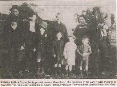
Newspaper - JENNY FOLEY COLLECTION: FAMILY FUN
Martin (1872-1948) and Mary Comer (1883-1972 married in 1907and had the following children; Edward Thomas (1908-1974) Leonard Laurence(1909-1931) Cecilia Mary (1911-1980) Joseph Benedict (1913-1989) Luke Bernard (1914-1931) Kevin Martin (1916-1986) Theresa Agnes (1918-1948) Francis Michael (1919-2000) Anthony John (1922-2011) Leonard and Luke worked with their father at Kimbolten and both drowned on the 28th December 1931, in the Goulbourn River at Arcadia near Murchison. A lad named Madden also drowned at the same time. The family lived in Queen Street, Bendigo.Bendigo Advertiser ''The way we were'' from 2003. Family fun: a Comer family portrait taken at Kimbolton, Lake Eppalock, in the early 1920s pictured is (from left) Ted, Leo, Joe, Cecilia, Luke, Kevin, Teresa, Frank and Tony with their parents Martin and Mary. The clip is in a folder.newspaper, bendigo advertiser, the way we were -
 Eltham District Historical Society Inc
Film - Video (DVD), Neisha Forbes et al, Tales of Old Nillumbik; stories of life in years gone by - Plenty Historical Society, 15 November 2005
A series of talks held October - December 2005 at the Eltham Living and Learning Centre which allowed Nillumbik Historical Societies to record the verbal history of the area with some of the well known residents of Nillumbik and surrounds Recorded and edited by Marie Ryan of Plenty Valley FM Speaker: Neisha Forbes 15th November 2005 This session covers the early settlement of Plenty. Learn about the mills situated on the Plenty River from the 1840s. Early industry such as fruit growing, poultry farming, goldmining, rabbit skinning and how they contributed to the development and employment of the area and in the case of rabbit skinning the development of other industries in Victoria during the Depressionvideo recording -
 Warrnambool and District Historical Society Inc.
Booklet, Warrnambool City Council voters roll 2001, 2002
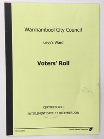
This is a booklet giving the names and addresses of voters for the local Council in Levy’s Ward in the City of Warrnambool in 2002. At that time the Warrnambool City Council was divided into seven Wards with one Councillor representing each Ward. The seven Wards at that time were Levy’s, Botanic, Cassady, Pertobe, Proudfoot, Sherwood, and Wollaston. In 2004 the Wards were abolished and seven Councillors then represented the whole City of Warrnambool. In October 2024, the Warrnambool municipality covered 120sqkms and returned to a seven ward council. In 2024, the wards were Botanic, Central, Hopkins River, Pertobe, Platypus Park, Russells Creek and Wollaston. In 2002 Glenys Phillpot was the Councillor representing Levy’s Ward. This booklet is of interest as it contains the names and addresses of those enrolled in Levy’s Ward in Warrnambool in 2002. It will be a useful booklet for researchers. This is a booklet of 22 pages containing the names and addresses of voters in the Levy’s Ward of Warrnambool in 2002. The cover is yellow and the booklet is bound with black taping. The printed list of names is in black type. Front Cover: ‘Warrnambool City Council’ ‘Levy’s Ward’ ‘Voters’ Roll’ ‘Certified Roll Entitlement Date: 17 December 2001.’ ‘February 2002 Victorian Electoral Commission’. warrnambool city council, city of warrnambool wards, history of warrnambool, levy’s ward, warrnambool city council, glenys phillpot -
 Eltham District Historical Society Inc
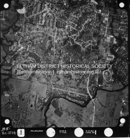
Photograph - Aerial Photograph, Landata, Montmorency / Lower Plenty, Jan. 1962
Centred on 147 Old Eltham Road, Lower Plenty bounded by Hurstbridge Railway Line to north, Yarra River to south, Main Road, Eltham to east and Heidelberg Golf Club to west. Historic Aerial Imagery Source: Landata.vic.gov.au Aerial Photo Details: Project No : 539 Project : MELBOURNE-GEELONG PROJECT Run : 6 Frame : 81 Date : 01/1962 Film Type : B/W Camera : RC5 Flying Height : 6000 Scale : 15840 Film Number : 1524 GDA2020 : 37°43'52"S, 145°07'26"E MGA2020 : 334685, 5822354 (55) Melways : 21 D9 (ed. 42)aerial photo, lower plenty, main road, montmorency, phoebe mason collection, eltham, eltham lower park, heidelberg golf club, hurstbridge railway line, main road eltham, yarra river -
 Eltham District Historical Society Inc
Photograph - Aerial Photograph, Landata, Montmorency / Lower Plenty, Feb. 1956
Centred on 20 Panorama Avenue, Lower Plenty bounded by Rattray Road to north, Yarra River to south, Bolton Street to east and Heidelberg Golf Club to west. Historic Aerial Imagery Source: Landata.vic.gov.au Aerial Photo Details: Project No : 250 Project : MELBOURNE OUTER SUBURBS PROJECT Run : 16A Frame : 53 Date : 02/1956 Film Type : B/W Camera : EAG9 Flying Height : 10000 Scale : 12000 Film Number : 1187 GDA2020 : 37°43'47"S, 145°07'25"E MGA2020 : 334645, 5822519 (55) Melways : 21 D9 (ed. 42)aerial photo, lower plenty, main road, montmorency, phoebe mason collection, bolton steet, heidelberg golf club, rattray road -
 Eltham District Historical Society Inc
Photograph - Aerial Photograph, Landata, Montmorency / Lower Plenty, Mar. 1987
Centred on 354-356 Main Road, Lower Plenty bounded by Rattray Road, Montmorency to north, Yarra River to south, Falkiner Street, Eltham to east and Lower Plenty shops to west. Historic Aerial Imagery Source: Landata.vic.gov.au Aerial Photo Details: Project No :1716 Project : WESTERN PORT FORESHORES Run : 16 Frame : 132 Date : 03/1987 Film Type : B/W Camera : RC10 Flying Height : 5600 Scale : 10000 Film Number : 4102 GDA2020 : 37°43'51"S, 145°07'38"E MGA2020 : 334968, 5822406 (55) Melways : 21 E9 (ed. 42)aerial photo, lower plenty, main road, montmorency, phoebe mason collection, eltham, eltham lower park, falkiner street, lower plenty shops, main road eltham, rattray road, yarra river -
 Mission to Seafarers Victoria
Journal (item) - Periodicals-Annual, Shiplovers' Society of Victoria, The Annual Dog Watch
This journal provides the reader with glimpses of the adventures and hardships of a seaman's life. Many of the stories are of sailing ships.Contributes to our knowledge of the importance of shipping and places on record those stories of the sea which would otherwise be lost.Contents Editorial - Fifty Years Past - Miss S.A.E. Strom - 5 The Port of Melbourne — A Historical View - Andy Gash - 8 We Moved the Cargoes - J. Beggs - 15 A Chaplain’s Chatterings - W.S. McUtchen - 19 Pilots - Late C.E. Borwick - 26 Up the River — Down the River - Lloyd Taylor - 27 Port Services in the Nineteenth Century - M.A. Syme - 45 The Schooner Enterprise - Roy Stuart - Roy Stuart - 49 The Port Phillip Sea Pilot Service - Capt. Michael Carolin - 53 Streamers - G.M. Naug - 60 Errata - - 60 War Diary of H.M.A.S. Bendigo Part 2 1942 - T.W. Richardson - 61 Fire Fighting Services in the Port of Melbourne - Frank M. Stockton - 75 Shipwreck - A. Roland Jones - 81 The Diary of Peter Charles Iredale - Colin Wilson - 87 The John Oxley - R.N. Thiele - 95 The Volunteer - Bert Attwood - 100 Sailing in Wharanui - W.P. Shemmeld - 101 Book Reviews - - 110 The Most Fascinating Immigrant — Marco Polo - K. Shewan - 111sailing ships, steamships, shipping, seafaring life, shiplovers' society of victoria, dog watch