Showing 7119 items matching "snowy-river"
-
 Wodonga & District Historical Society Inc
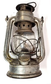
Domestic object - Kerosene Lantern
During the Victorian goldrushes of the 1850s thousands of Chinese migrants arrived to seek their fortunes. At that time many came to the lucrative gold fields of Northeast Victoria. After the Gold rush, many Chinese migrants returned home. However, a number settled in the area as merchants, hawkers and market gardeners in surrounding towns including Wodonga, the Ovens, King, Buffalo River and Kiewa Valleys. They also rented lands and established themselves in the hops and tobacco farming industries. Items of Chinese origin made their way into many households. Importation of Chinese mass produced items such as this lantern continued well into the 20th century and were common domestic items across Australia before households were connected to electricity.This item is representation of kerosene / paraffin lamps used throughout Australia to provide lighting inside and outdoors prior to the widespread availability of electricity.A small hurricane lamp with a rounded tank and small carry handle attached to the top. A larger handle is also attached at the top of the frame. It has a lever to open the glass tank. It has a metal base which is filled with kerosene. It has a screw knob to open the kerosene receptacle. The metal hood also has vents. The Chinese characters around the base translate to "Shanghai Guanghuaheng".Around base : Chinese characters. On top : "Made in China KWANG HWA"kerosene lamp, domestic appliances, chinese artefacts -
 Wodonga & District Historical Society Inc
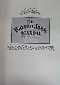
Book - The Barren Jack Scandal and its Effects on the M.I.A, W. R. Cowper, 1987
This book outlines the issues and controversy around the construction of the Barren Jack (Burrinjuck) Water Supply Dam as part of the infrastructure of the Murrumbidgee Irrigation Authority (M.I.A) and its subsequent abandonment. It has now fallen into disrepair,non-fictionThis book outlines the issues and controversy around the construction of the Barren Jack (Burrinjuck) Water Supply Dam as part of the infrastructure of the Murrumbidgee Irrigation Authority (M.I.A) and its subsequent abandonment. It has now fallen into disrepair,irrigation -- government policy, murrumbidgee irrigation area (n.s.w.) -- history, barren jack dam, burrinjuck, yass valley -
 Merri-bek City Council
Lithograph, John Wolseley, After the Fire - Leaf Surge, 2003
British born artist John Wolseley relocated to Australia in 1976, where he travelled extensively through the outback mainly recording the natural history of remote north Australia in large, minutely detailed paintings. Since 2009, he has travelled to Darwin annually to continue his exploration of the Top End, visiting Arnhem Land and Daly River to work with Indigenous artists to research and capture the detail and essence of particular landscapes. His works reflect how landscape can be thought of as fields of energy in which plant forms move or dance with rhythmic life. After The Fire - Leaf Surge represents the vibrant regrowth of new foliage emerging from a landscape recently ravaged by fire. -
 Kiewa Valley Historical Society
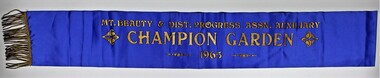
Sash, Mount Beauty Garden Sash
1947 The SEC created an Arboretum and Nursery on the bank of the West Kiewa River. Householder could collect free plants, trees and topsoil for their gardens. It was not long before there was very keen competition amongst the families to create the best garden. 1948 A Mount Beauty Garden competition started with a first prize of 15 pounds, second 7 pounds and third 3 pounds. As the oldest garden in the competition was only 25 months old and most were younger a handicap system of 4 points per month was devised. Tom Mitchell MLA was the donor and judge. 1965 This sash was possibility worn by Jean McCullough in 1965 when the Mt Beauty & District Progress Association Auxiliary ran the completion.An example of the social life at Mt Beauty during the construction of the Kiewa Hydro Electric Scheme.Royal blue sateen sash with gold fringe. Mt. BEAUTY & DIST. PROGRESS ASSN. AUXILIARY/CHAMPION GARDEN/1965textiles, arboretum, mount beauty, garden competition, kiewa hydro electric scheme -
 Orbost & District Historical Society
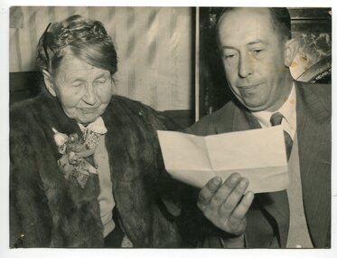
black and white photograph, 16.7.1956
This photograph shows Nelson Burn reading a telegram from the queen to his grandmother, Mrs Paul Hocking, on her 100th birthday. Her husband, James Hocking, was the first watchmaker in Orbost. He had been a lay preacher at Wangaratta and Yan Yean before coming to Orbost. He was an 1891 Rechabite and an Orbost Shire Councillor. Eliza Ann Hocking (nee Eddy) was born on 16.7.1856 at Blackwater Hall in England, She had arrived in Australia on the sailing boat "Poocia" on 8-7-1880. The voyage following the Cape route took about 7 weeks. For a time, with her husband, she lived at Chewton, on the gold fields, before coming to Orbost. She was a foundation member of the Methodist Ladies’ Guild in 1912. She lived in Salisbury Street, Orbost. She died on 9.4.1957. Colin Nelson Burn, born 7.7.1921, was her grandson, son of Robert Alfred Burn and Edith Jane Hocking. He began Sta-Brite' Painting and Decorating Services in Salisbury Street, Orbost. He served in the forces during World War II. He was a Life member of the Snowy Rovers Football Club. He joined the Orbost Fire Brigade on 1-5-1946. He died 1.2.2015. His son, Peter continues the painting business in Orbost. (info. from John Phillips)This is a pictorial record of an Orbost resident reaching 100 years. A 100 year birthday is a significant milestone. The Hocking / Burn family have been associated with the Orbost district since 1889.A large black / white photograph of an elderly lady standing beside a younger man who is holding a letter and reading to her.hocking-mrs burn-nelson telegram-queen-100th-birthday -
 Orbost & District Historical Society
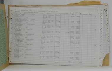
rate books, 1977 - 1984
These items were donated to Orbost & District Historical society from P.R.O.V. as a Place of Deposit (POD) item for safe keeping by a local history group or museum. The shire covered an area of 9,347 square kilometres and existed from 1892 until 1994 when it became part of the East Gippsland Shire Council. The East Gippsland Region Water Authority was constituted on January 1, 1995. The new Authority assumed responsibility for the services previously provided by the Mitchell Water Board, the Tambo Water Board, the Orbost Water Board and the Mallacoota Water Board. East Gippsland Water is the registered business name of the East Gippsland Region Water Authority. (info. from P.R.O.) These items are a historical record of Orbost Shire transactions with water management authorities which no longer exist.Seven rate books for the Shire of Orbost, Mallacoota and Cann River Water Trust. 2554.1 with records from 1977-1978 has a brown cardboard cover and string binding. 2554.2 has a brown cardboard cover with a hand-written title and green string binding. Records are from 1978 -1979. 2554.3 has a brown cardboard cover with a hand-written title and green string binding. Records are from 1919 - 1980. 2554.4 has a white cardboard cover and taped spine. In black print on the cover is 1980/1981. 2554.5 has a green cover with a metal fastening clip. Records are from 1980 -1981. 2554.6 has a white cover, taped binding and metal clips.Records are from 1982 -1983. 2554.7 has a white cover and metal rings. It is dated 1984.water-rates cann-valley-water-board -
 Ballarat Tramway Museum
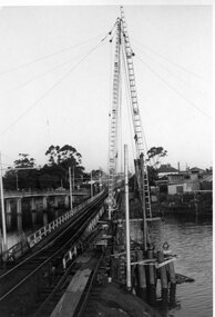
Photograph - Black & White Photograph/s, mid to Late 1965
Set of two Black and white photographs of the pile driving for the reconstruction of the Maribyrnong River Bridge from a tramway only bridge to a dual road/tram bridge. The road bridge is in the background. On Kodak paper. Photo during the 2nd half of 1965. 1419.1 - Early in the process of pile driving - Bridge tram track has been reduced to single track and the former outbound line is in use for construction purposes. 1419.2 - Roadway west of bridge looking east. Shows temporary single track arrangement which allowed the operating track to switch to the south side when piling completed. W5 682 West Maribyrnong on route 57 coming off the bridge. See P.Winspur note - and Rail News Victoria May 2000, page 50. Features a photograph of a tour on the bridge on 1/10/1966.trams, tramways, maribyrnong river bridge, bridge construction, trackwork, mmtb, tram 682 -
 Bendigo Historical Society Inc.
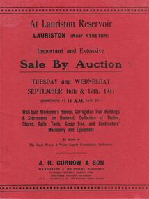
Document - IAN DYETT COLLECTION: AUCTION CATALOGUE - LAURISTON RESERVOIR
Two red covered auction catalogues for an Auction Sale at Lauriston Reservoir, Lauriston (Near Kyneton) on 16th and 17th September, 1941. Sale consisted of Well-built Workmen's Homes, Corrugated Iron Buildings & Storerooms for Removal, Collection of Timber, Stores, Rails, Tools, Scrap Iron, and Contractors' Machinery and Equipment By Order of The State rivers & Water Supply Commission, Melbourne. Auctioneers were J. H. Curnow & Son. Contains description of buildings. Has a loose page of Additional Plant to be sold at the Lauriston Reservoir Auction on 17/9/1941. Also has two black and white photos, the first one of the Lauriston Reservoir showing the concrete bank during construction and the other, a Section of Residential Area. In the background is the bank and a tower each side of the bank.business, auctioneers, j h curnow & son pty ltd, ian dyett collection - auction catalogue - lauriston reservoir, state rivers & water supply commission, j h curnow & son, j l jamieson & co, r g knight, e d shaw, h h c williams, hon a a dunstan, cambridge press -
 Kew Historical Society Inc
Photograph - Grampians, 1924
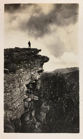
Henry Beater Christian (1886-1962) , was a descendant of one of the earliest settler families in Kew. Employed at the Kew Asylum as a 'public servant', he was a skilled amateur photographer, photographing numerous scenes in Kew and on his travels around Victoria. The majority of his photographs date from 1916 to 1929. His finest photographs are housed in two photograph albums. Digital copy of a photograph from page 12 of the 47-page photograph album containing 261 gelatinous silver images, loaned by Diane Washfold with permission given to digitise and hold a copy in our collection. The first and last pages in the album document the Yarra River at Studley Park and at Kew. The remainder of the album includes photographs of walking and car tours in rural Victoria including 'wilderness' areas in the Grampians, Gippsland and the High Country. Six album pages document a camping trip by Henry Christian to the Grampians in September 1924. The photos include pictures of lookouts, and natural features including rock faces and waterfalls, as well as his camp site. This photo is of a man, perhaps Henry Christian, standing on one of the lookouts on what is probably the Mt Victory trail. "Mt Victory / Grampians / 9.24"henry beater christian (1886-1962), landscape photography, christian-washfold collection, photograph albums, grampians, mt victory, gariwerd -
 Kew Historical Society Inc
Photograph - Campsite in the Grampians, 1924
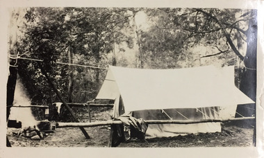
Henry Beater Christian (1886-1962) , was a descendant of one of the earliest settler families in Kew. Employed at the Kew Asylum as a 'public servant', he was a skilled amateur photographer, photographing numerous scenes in Kew and on his travels around Victoria. The majority of his photographs date from 1916 to 1929. His finest photographs are housed in two photograph albums. Digital copy of a photograph from page 12 of the 47-page photograph album containing 261 gelatinous silver images, loaned by Diane Washfold with permission given to digitise and hold a copy in our collection. The first and last pages in the album document the Yarra River at Studley Park and at Kew. The remainder of the album includes photographs of walking and car tours in rural Victoria including 'wilderness' areas in the Grampians, Gippsland and the High Country. Six album pages document a camping trip by Henry Christian to the Grampians in September 1924. The photos include pictures of lookouts, and natural features including rock faces and waterfalls, as well as his camp site. This photo is of one of his campsites. The tent, beside which a man is standing, is a simple canvas sheet is supported by saplings and ropes. "Mt Victory / Grampians / 9.24"henry beater christian (1886-1962), landscape photography, christian-washfold collection, photograph albums, grampians, mt victory, gariwerd -
 Kew Historical Society Inc
Photograph - Grampians, 1924
Henry Beater Christian (1886-1962) , was a descendant of one of the earliest settler families in Kew. Employed at the Kew Asylum as a 'public servant', he was a skilled amateur photographer, photographing numerous scenes in Kew and on his travels around Victoria. The majority of his photographs date from 1916 to 1929. His finest photographs are housed in two photograph albums. Digital copy of a photograph from page 15 of the 47-page photograph album containing 261 gelatinous silver images, loaned by Diane Washfold with permission given to digitise and hold a copy in our collection. The first and last pages in the album document the Yarra River at Studley Park and at Kew. The remainder of the album includes photographs of walking and car tours in rural Victoria including 'wilderness' areas in the Grampians, Gippsland and the High Country. Six album pages document a camping trip by Henry Christian to the Grampians in September 1924. The photos include pictures of lookouts, and natural features including rock faces and waterfalls, as well as his camp site. This is a photo of a man wearing a hat and sturdy walking clothes standing on the edge of one of the precipitous lookouts at the Grampians. The man may be Henry Christian or a companion."Grampians"henry beater christian (1886-1962), landscape photography, christian-washfold collection, photograph albums, grampians, gariwerd -
 Kew Historical Society Inc
Photograph - Campsite in the Grampians, 1924
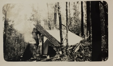
Henry Beater Christian (1886-1962) , was a descendant of one of the earliest settler families in Kew. Employed at the Kew Asylum as a 'public servant', he was a skilled amateur photographer, photographing numerous scenes in Kew and on his travels around Victoria. The majority of his photographs date from 1916 to 1929. His finest photographs are housed in two photograph albums. Digital copy of a photograph from page 15 of the 47-page photograph album containing 261 gelatinous silver images, loaned by Diane Washfold with permission given to digitise and hold a copy in our collection. The first and last pages in the album document the Yarra River at Studley Park and at Kew. The remainder of the album includes photographs of walking and car tours in rural Victoria including 'wilderness' areas in the Grampians, Gippsland and the High Country. Six album pages document a camping trip by Henry Christian to the Grampians in September 1924. The photos include pictures of lookouts, and natural features including rock faces and waterfalls, as well as his camp site. This photo is of a campsite with a pitched tent supported by slabs of bark and ropes. A man is standing in front of the tent partly obscured by the smoke."Grampians"henry beater christian (1886-1962), landscape photography, christian-washfold collection, photograph albums, grampians, mt victory, gariwerd -
 Kew Historical Society Inc
Photograph - Moyne River Bridge, c.1926
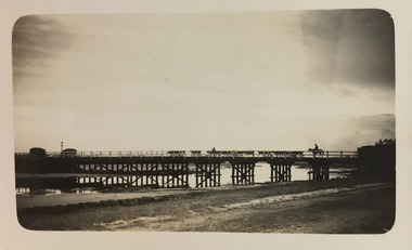
Henry Beater Christian (1886-1962) , was a descendant of one of the earliest settler families in Kew. Employed at the Kew Asylum as a 'public servant', he was a skilled amateur photographer, photographing numerous scenes in Kew and on his travels around Victoria. The majority of his photographs date from 1916 to 1929. His finest photographs are housed in two photograph albums. Digital copy of a photograph from page 24 of the 47-page photograph album containing 261 gelatinous silver images, loaned by Diane Washfold with permission given to digitise and hold a copy in our collection. In the 1920s, the photographer travelled throughout Victoria, including on the west coast from Port Campbell to Port Fairy. Trips were presumably made by train and by foot. Lynda Tieman and her team at the Port Fairy Historical Society have tentatively identified a number of Henry Christian's photographs of Port Fairy, of which this is one. The photo captures a man on a horse, believed to be Bill Digby, driving a herd of cattle across the Moyne River Bridge. The photo is shot into the man light source, leading to the bridge and those who cross it being shown in silhouette.henry beater christian (1886-1962), landscape photography, christian-washfold collection, photograph albums, moyne river bridge, port fairy (vic.), bill digby, cattle drovers -
 Kew Historical Society Inc
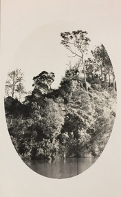
Photograph - Tambo River, 1926
Henry Beater Christian (1886-1962) , was a descendant of one of the earliest settler families in Kew. Employed at the Kew Asylum as a 'public servant', he was a skilled amateur photographer, photographing numerous scenes in Kew and on his travels around Victoria. The majority of his photographs date from 1916 to 1929. His finest photographs are housed in two photograph albums. Digital copy of a photograph from page 31 of the 47-page photograph album containing 261 gelatinous silver images, loaned by Diane Washfold with permission given to digitise and hold a copy in our collection. John Chapman has written in 'Bushwalking Clubs - A Brief History', about the establishment in Victoria of the first bushwalking club in 1888, and the popularisation of bushwalking during the interwar period. Henry Christian's 'walks' appear to have been undertaken solely or with a companion/s. This black and white photo is part of a group of six photos taken on an 18 kilometre walking trip between Bruthen and Swan Reach in East Gippsland in 1926. The route of the walk followed the Tambo River. The photographer has focussed the view using an oval frame during the development process."BRUTHEN TO SWAN REACH 1926"henry beater christian (1886-1962), landscape photography, christian-washfold collection, photograph albums, bushwalking, bruthen, swan reach, tambo river, east gippsland -
 Kew Historical Society Inc
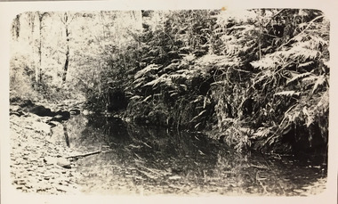
Photograph - Small creek between Bruthen and Swan Reach, 1926
Henry Beater Christian (1886-1962) , was a descendant of one of the earliest settler families in Kew. Employed at the Kew Asylum as a 'public servant', he was a skilled amateur photographer, photographing numerous scenes in Kew and on his travels around Victoria. The majority of his photographs date from 1916 to 1929. His finest photographs are housed in two photograph albums. Digital copy of a photograph from page 31 of the 47-page photograph album containing 261 gelatinous silver images, loaned by Diane Washfold with permission given to digitise and hold a copy in our collection. John Chapman has written in 'Bushwalking Clubs - A Brief History', about the establishment in Victoria of the first bushwalking club in 1888, and the popularisation of bushwalking during the interwar period. Henry Christian's 'walks' appear to have been undertaken solely or with a companion/s. This black and white photo is part of a group of six photos taken on an 18 kilometre walking trip between Bruthen and Swan Reach in East Gippsland in 1926. The route of the walk followed the Tambo River. The photographer has focussed the view on a small creek between the two towns."BRUTHEN TO SWAN REACH 1926"henry beater christian (1886-1962), landscape photography, christian-washfold collection, photograph albums, bushwalking, bruthen, swan reach, tambo river, east gippsland -
 Kew Historical Society Inc
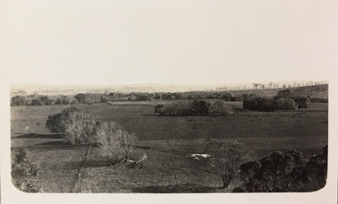
Photograph - Farmland, near or between Bruthen and Swan Reach, 1926
Henry Beater Christian (1886-1962) , was a descendant of one of the earliest settler families in Kew. Employed at the Kew Asylum as a 'public servant', he was a skilled amateur photographer, photographing numerous scenes in Kew and on his travels around Victoria. The majority of his photographs date from 1916 to 1929. His finest photographs are housed in two photograph albums. Digital copy of a photograph from page 31 of the 47-page photograph album containing 261 gelatinous silver images, loaned by Diane Washfold with permission given to digitise and hold a copy in our collection. John Chapman has written in 'Bushwalking Clubs - A Brief History', about the establishment in Victoria of the first bushwalking club in 1888, and the popularisation of bushwalking during the interwar period. Henry Christian's 'walks' appear to have been undertaken solely or with a companion/s. This black and white photo is part of a group of six photos taken on an 18 kilometre walking trip between Bruthen and Swan Reach in East Gippsland in 1926. The route of the walk followed the Tambo River. The photographer focusses the camera view on distant farmland near or between either of the two towns."BRUTHEN TO SWAN REACH 1926"henry beater christian (1886-1962), landscape photography, christian-washfold collection, photograph albums, bushwalking, bruthen, swan reach, tambo river, east gippsland -
 Wodonga & District Historical Society Inc
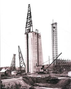
Album - Hume Reservoir Australia Album - Concrete pillar for tall tower, New South Wales, August 1927
This set of photos is from a leather bound album bearing the inscription "HUME RESERVOIR AUSTRALIA" plus 'The Rt. Hon. L. C. M. S. Amery, P. C., M .P.' all inscribed in gold. It was presented to The Rt. Hon. L. C. M. S. Amery, P. C., M. P, Secretary of State for Dominion Affairs on the occasion of his visit to the Hume Reservoir on 2nd November 1927. This album is of local and national significance as it documents the planning and development of the Hume Reservoir up to 1927. It was the largest water reservoir in the British Empire. The album records the pioneering engineering work that went into its construction.DEPARTMENT OF PUBLIC WORKS, N.S.W. RIVER MURRAY WATERS SCHEME. HUME RESERVOIR. 28. Concrete Pillar for Tail Tower. This shows the back and upstream side of the tower. The groove at the back is left for the reception of the concrete core wall of the earth embankment. The groove is being used at present as a hoist well, up and down which men and materials are conveyed in connection with the re-erection of the Tail Tower of the cableway. The pillar is 108 feet from the ground and is within 4 feet of its ultimate height. The foundation of this part at its deepest is 90 feet below the natural surface so that when the 80 feet tower and jury mast are in place the total height from foundation to top of mast will be about 300 feet. New South Wales, August 1927.hume reservoir australia, river murray waters scheme, hume reservoir construction -
 Melbourne Tram Museum
Document - Personal Papers, Melbourne & Metropolitan Tramways Board (MMTB), "Agreement between MMTB and the Commonwealth of Australia, c1940
Set of personal papers - typed carbon copies - copy of "Agreement between MMTB and the Commonwealth of Australia for the construction of tramways to serve the Munition Factories at Footscray and Maribyrnong" dated 22/7/1941 and 21/6/1944 to extend tramways. Covers maintenance, construction costs, finances, property issues and provides details in a schedule. .1 - agreement dated 22/7/1941 - Gordon St extensive, Raleigh's Road and West Road to Williamson Road and Raleigh's road to Park Road. .2 - dated 21/6/1944 - extension of Keilor Road to Essendon Airport. .3 - undated - agreement re double track Maribyrnong Road, Gordon St, West Road, Essendon Depot works, Maribyrnong River Images and record revised 20/5/2019.trams, tramways, mmtb, tramways, commonwealth government, agreements, munitions factory, maribyrnong, footscray -
 Melbourne Tram Museum
Slide - Set of 7, Len Millar, 18/04/1974 12:00:00 AM
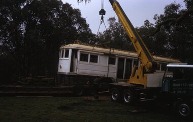
Set of seven Kodak white cardboard 35mm colour slides by Len Millar of the move of former VR tram No. 34 from Yarrambat to the TMSV site at Bylands on 18/4/1974. Reference June 1974 issue of Trolley Wire. Note the Brill 77E trucks i the background were obtained at the same time. These would have been 5'3" gauge and it would appear that the tram was placed on a set of MMTB No. 1 trucks. Len Millar advised 21-7-2021 - that Trolley Wire says that the tram was obtained from a private property on the banks of thee Plenty River at Yarrambat, It was perched on a steep slope only 50 metres from the house, but two kilometres in from the nearest road. The track out to the nearest road was steep, rough and akin to a “goats’ track”!trams, tramways, vr trams, recovery, transporting trams, tmsv, bylands, tram 34 -
 Melbourne Tram Museum
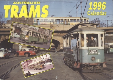
Ephemera - Calendar, Topmill Pty Ltd, "Australian Trams - 1996 Calendar", 1995
Wall Calendar - heavy card covers, 12 gloss art pages inside, titled "Australian Trams - 1996 Calendar" containing cull colour photographs of Sydney, Adelaide, Bendigo, Ballarat, Melbourne, Fremantle 29 and Victor Harbor. Has a punched hole along the top edge to enable wall use. Provides dates for holidays, school holidays and Pension payment days and phases of the moon. Produced by Topmill Pty Ltd and distributed by Gordon & Gotch Pty Ltd. All Photos by Dr D. Ellerton. Features large format photos of 672 crossing the wooden Maribyrnong River Bridge, 672, 671, 980, X2 676, X 217, VR 52, S164 Second copy from AETA collection added 17/1/1014.trams, tramways, ballarat, bendigo, melbourne, adelaide, sydney, tram 672, tram 671, tram 980, tram 217, tram 52, tram 164 -
 Kew Historical Society Inc
Photograph - Yarra Street, Kew, Ron Setford, 1960
Ron Setford and his wife Grace Setford lived in Tanner Avenue, East Kew, from c.1946 to c.1995. A keen photographer, he recorded the changing face of Kew over a 20 year period. Apart from 30 photographs of built structures and places in Kew dating from 1960 and 1961, 145 of his 35mm colour slides chronicle the development of the Eastern Freeway through the Yarra Valley over a five year period from c.1972 to c.1977. This important collection was donated to the Society by his granddaughter in 2025.This collection of 175 35mm slides is of local and statewide significance, owing to its subject matter, particularly the major development of road transport infrastructure during the 1970s with the construction of the Eastern Freeway. The photographer also took care to annotate and date most of his slides which enable the researcher to pinpoint temporal and spatial locations.Yarra Street was not made a trafficable thoroughfare until October 1956. Until then, the gully was used as a dump, a shortcut to the river, and for communal Guy Fawkes night bonfires. The open landscape in the photo reflects near-total clearing by the original estate owners for grazing livestock. Post-war homes fronting Stawell St dot the landscape. Of particular note are the Broons House (c.1952–54) by Anatol Kagan (top right), and the homes of two architects, Kurt Elsner (c.1950) (middle) and Geoffrey Danne (c.1954) (lower right). Dual carriageways made blocks accessible, but building was difficult due to steeply sloping land and complex drainage easements. Nevertheless, these challenges resulted in highly innovative designs, making Yarra Street the core of the Yarra Boulevard Heritage Precinct."Yarra St Kew"ron setford, photographs -- kew (vic.) -- 1960s, yarra street -- kew (vic.) -
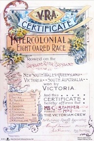 Albert Park-South Melbourne Rowing Club
Certificate, Handasyde and Goldsworthy, V.R.A Certificate / Intercolonial Eight-Oared Race, 1900
A colour certificate given to the winners of the 1900 Intercolonial Eight-Oared Race. Rowed on the BRISBANE RIVER, BRISBANE / 12th May, 1900 / BETWEEN THE COLONIES OF / NEW SOUTH WALES - QUEENSLAND -- / VICTORIA -- SOUTH AUSTRALIA -- / won by / VICTORIA / J. DONALD Stroke / T. DAVIES No. 7 / H.J. HUGHES …6 / A. HALL …5 / A. DAWSON …4 / J. COCKBILL ...3 / C. STAMPER ...2 / J. SUFFREN ...Bow / J. COUNIHAN Cox / J.M. MACFARLANE Honorary Coach / And this / CERTIFICATE / hereby affirms that / C. STAMPER / rowed No. 2 in / THE VICTORIAN CREW. / For Victorian Rowing Association / (Signature) President / (Signature) Hon. Secretary -
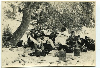 Orbost & District Historical Society
black and white photograph, January 1, 1897
This photograph shows Mr John Bird ( 3rd from left) ; Mr John Gilbert and Mr Lance Herbert among others having a picnic at the popular beach paddock at Old Station, Corringle, on January 1, 1897. Late in 1857 Mr Thomas T. Stirling took over Corringle Run ("Corringle" means "shallow water"). Mr Stirling and his family came from the wester district - Winchelsea. He settled at the Old Station. A few people were employed at the Orbost Stationb and there was settlement on the Orbost flats, Mr T. T. Stirling held the land from Lake Tyrers to Bemm River as a cattle run. About 1888 he became Secretary of the new Tambo Shire.This photograph is a portrait of rural life in the late 19th century. It is an insight into the dress, manners and activities of the first settlers of Orbost.Two copies of a black / white photograph of a group of men and women picnicking on the sand under tall trees.on back - "Beach Paddock - Old Station -1897" with a list of namesold-station-orbost rural-family-life -
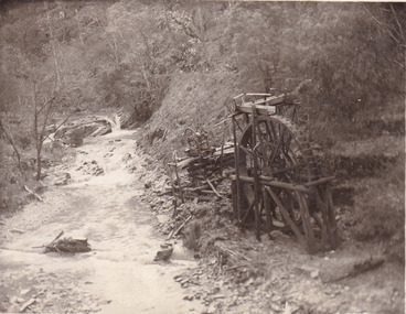 The Beechworth Burke Museum
Postcard, 1920
This postcard depicts the set-up of an abandoned gold mine. This includes a water wheel and other mining implements next to a creek. The postcard inscription indicates that this image is of the remains of the Wallaby Reef battery and water wheel. Wallaby Reef was discovered in 1864, and a prospecting claim established a four head battery and water wheel. Quartz was mined there, with gold also discovered at this location at a later date. By 1878 the mine was no longer resulting in rich deposits, this resulted in the miners moving their search for gold closer to the river where they were able to access more gold. This was in approximately 1879. In 1882 a rich deposit was found. In 1908 the battery was closed, and the mine finished. This photo was taken in 1920 and shows the deterioration of the site since its closure. Gold mining was crucial to the development of the Beechworth area. It has strong research and historical value because the clarity of the photo shows all the minute details of the mining equipment. The text on the back also indicates the mine is the Wallaby Mine, which was used for 45 years to find gold and quartz. Therefore, due to the location being quickly abandoned, this site is a rich location for historical study on gold mining during the 1900s. It can provide important information on the types of tools utilised and the impact of the mining on the environment.Black and white postcard photograph on card.8169 Be / Also near Wallaby Reef Workings / Relics of Rechabite Reef (locality) workings. / Shaft in bed of creek. Wheel used to drive sheadd (?) / stamp battery too I believe near B'worth 1920?beechworth, mining, gold mining, quartz mining, wallaby reef mine, mine battery head -
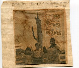 Kiewa Valley Historical Society
Newspaper clipping 11/7/72 Canoe tree in Kiewa & Photo-Tawonga Homestead
1. Kiewa Valley Consolidated School was established in 1953 combining Dederang North, Kergunyah, Gundowring, Kiewa, Gundowring Upper, Red Bluff, Charleroi and Gundowing North schools on a 10 acre site with 11 rooms at Kiewa. The bark was cut from the canoe tree, by aboriginal craftsmen, to produce a canoe for fishing in the rivers running through the Kiewa Valley either before or just after the 1800's. The tree trunk, located at Kiewa, would have been used at the beginning of European settlement in the Kiewa Valley or just before contact was made. 2. Pictorial record of the graves of early pioneers C Ibbotson, Mrs Elizabeth Eyre and John Eyre who died between 1858 – 1904, all located at Tawonga Homestead 1. The above schools are in the Kiewa Valley. The date and number of combined schools give insight into the change in population and families in the Kiewa Valley before and after 1953. The tree was found along the Kiewa River and indicates that Aborigines lived by the river and used tree bark to craft canoes to cross rivers and to fish in the deeper sections of the river. 2. Pictorial record of the early history of Kiewa Valley pioneers whose descendants have lived and worked in the Kiewa Valley for many years 1. Newspaper article of local school children visiting a canoe tree in Kiewa July 11, 1972. mounted on buff card 2. Black and white photo of pioneer graves at old Tawonga Homestead. Mounted on buff card 1. Handwritten in black ink above newspaper clipping ‘Canoe Tree Kiewa Valley Consolidated School. 11 July, 1972’ Handwritten in pencil at bottom of article ’10 Nov. ‘72’ 2. Handwritten in black ink above photo ‘Tawonga Homestead graves’ Handwritten below photo ‘T Ibbotson D. 1858, Elizabeth Eyre D. 1879, John Eyre D 1879, John Eyre D. 1904 tawonga homestead, canoe tree at kiewa, tawonga graves -
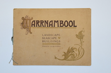 Warrnambool and District Historical Society Inc.
Booklet, Walter Davies, Warrnambool, Warrnambool - Landscape, Seascape, Buildings, early 20th century
This is a souvenir booklet Souvenir Booklet of WarrnamboolThis is a booklet of 16 pages. The cover is buff-coloured and has ornamental patterns and brown printing on the front cover. The pages contain printed text and 24 black and white photographs. Some pages have handwritten annotations.non-fictionThis is a souvenir booklet Souvenir Booklet of Warrnamboolwarrnambool tourism, walter davies bookseller warrnambool -
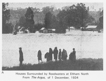 Eltham District Historical Society Inc
Work on paper (Sub-Item) - Photograph, Houses surrounded by floodwaters at Eltham North
"The house (centre) at North Eltham in which Mr. and Mrs. William Frizell, an elderly couple, were marooned by flood waters. When this photograph was taken late yesterday afternoon the couple were still inside the house, and through a ventilator they had stuck a red flag which they waved from time to time. The house on the left belongs to Mr. Leads, who also was marooned." - The Argus 1 December 1934. John William Frizell, painter and his wife Sarah Jane are registered at Glen Park, Eltham in the 1924 Electorial Roll This was most probably the Diamond Creek in flood. In 1934 extensive flooding of the Yarra River and Diamond Creek sets new records for flood plain level (via Chronology of Eltham, EDHS) flood, frizell, leads, argus, glen park, eltham north, flooding, marooned, diamond creek -
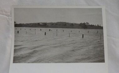 Wycheproof & District Historical Society Inc.
Photograph, Mr Ernie Taylor, Cooroopajerrup Creek 1923, 1923 (exact)
The semi-mythical stream, the Cooroopajerrup Creek. Before there were any channel banks and formed roads, this creek shared the Avoca flood waters with the Tyrrell Creek. In more recent times the Wycheproof channel prevented the major floods of 1956 and 1973 from following the old river course. Also there is said to have been some shifting of the sand-hills at Teddywaddy which have blocked much of the old Cooroopajerrup flow. Little is known of earlier records, but The Mount Wycheproof Ensign records flooding of the creek in 1909. 2011 saw the Cooroopajerrup flow again after 88 years. This 2011 photo was taken at about the same position as the 1923 photo. The modern steel roadway fence is submerged. see-Photograph-Record No 001997.Copy of a B&W photograph of the Cooroopajerrup-Creek in flood-1923. To the north is Mount-Wycheproof, with the hospital barely visible behind the trees just left of centre, and a few scattered dwellings. The nearer railway-fence follows the road leading to the current saleyards.The outer fence has been replaced with a modern steel fence.None1923, cooroopajerrup creek, flood, mount wycheproof -
![Photograph - Digital image, House St Helena and Diamond Creek Roads [Greensborough], 02/05/2013](/media/collectors/4f729f5697f83e03086015b8/items/5729bbd22162f108e8de5be2/item-media/5729bc112162f108e8de617d/item-fit-380x285.jpg) Greensborough Historical Society
Greensborough Historical SocietyPhotograph - Digital image, House St Helena and Diamond Creek Roads [Greensborough], 02/05/2013
These photographs of the house on the corner of St Helena and Diamond Creek Roads was taken in 2013 to show changes over 40 years, based on Ron Reynold's sketches in the 1973 publication 'Greensborough and Greenhills' published by Cypress Books... which states "Built on a steep hill in a bush setting in the early 1920s, for a Dr Wood, the weatherboard house now overlooks an area of activity and change. The owners, Mr and Mrs E. 'Bluey' Blackburn, remember when their 3/4 acre building block dropped to the edge of a dirt road. Today the view from the high verandah encompasses the Main Street shopping centre, new and old bridges, new roads and houses, the Plenty River, natural bush, hills and sports grounds."Digital copy of colour photograph.greensborough and greenhills, st helena road greensborough, diamond creek road greensborough, wood family, ron reynolds -
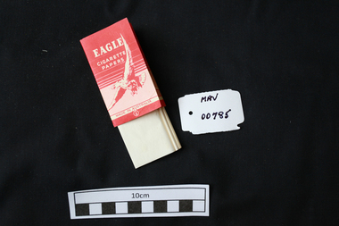 City of Moorabbin Historical Society (Operating the Box Cottage Museum)
Manufactured objects, Cigarette paper, ‘Eagle’, mid 20thC
Rolling papers are small sheets, rolls, or leaves of paper which are sold for rolling cigarettes either by hand or with a rolling machine. When rolling a cigarette, one fills the rolling paper with tobacco. Rolling papers are most commonly made with wood pulp, hemp, flax, or rice straw as a base material. 1860 Samuel Ramsden, a Yorkshire man, founded first paper mill in Victoria on the banks of the Yarra River, Fairfield, Melbourne. This was the Australian Paper and Pulp Company which for most of its history was called The Australian Paper Manufacturers Ltd. until it changed its name in 1986 to Amcor. In 1919 the company opened its mill on the corner of Upper Heidelberg Road and The Chandler Highway in Fairfield and remains there today. A packet of pre-cut cigarette papers 'Eagle ' brandEAGLE / CIGARETTE / PAPERS / MADE IN AUSTRALIA back 60 PAPERSciagarette papers, cigarettes, tobacco, melbourne, moorabin, paper mills, eagle cigarette papers ltd, australian paper manufacturers ltd, fairfield victoria,