Showing 10994 items matching " land"
-
 Bendigo Historical Society Inc.
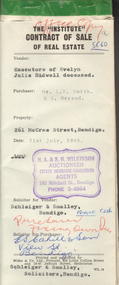
Document - H.A. & S.R. WILKINSON COLLECTION: CONTRACT OF SALE
This business was owned by father and son, Henry Archibald Wilkinson and Samuel Ronald "Ron" Wilkinson. Henry (1882-1954) was born in Shepparton and died in Bendigo. He was married to Grace Hovendon in 1908. Samuel Ronald "Ron" (1914-1995), Henry's son, was married to Florence Jean McKerlie in 1937.Contract of sale of real estate dated 21st July, 1965 between Sandhurst and Northern district Trustees Executors and Agency Company Limited of View Street, Bendigo as executors of the estate of Evelyn Julie Bidwell deceased (seller) and Mr. L.B. Smith & Mr. A. Heraud (buyers). Solicitor for vendor: Schleiger & Smalley, Bendigo. Solicitor for purchaser: E.S. Cahill & Son, View Street, Bendigo. Property at No.261 McCrae Street, Bendigo being part of Crown allotment 6 section 92C being land described in certificate of title volume 4507 folio 334, together with all floor coverings, blinds, curtains and electric light fittings and shades. Price 1,300 pounds.organization, business, h.a. & s.r wilkinson real estate -
 Bendigo Historical Society Inc.
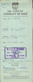
Document - H.A. & S.R. WILKINSON COLLECTION: CONTRACT OF SALE
This business was owned by father and son, Henry Archibald Wilkinson and Samuel Ronald "Ron" Wilkinson. Henry (1882-1954) was born in Shepparton and died in Bendigo. He was married to Grace Hovendon in 1908. Samuel Ronald "Ron" (1914-1995), Henry's son, was married to Florence Jean McKerlie in 1937.Contract of sale dated 15th April, 1959 between Mr. F. Kupke (seller) and Mr. P. 7 Mrs. F.E. Stevens (buyers). Solicitor for vendor: Hyett, Willis & Hyett, Bull Street, Bendigo. Solicitor for purchaser: E.S. Cahill & Son, View Street, Bendigo. Property in Sparrow Hawk Road, St. Just Point being allotments 65 and 66 section L containing 15 acres, 17 perches and being land described in Crown grant volume 7615 folio 125, together with all buildings and erections thereon, also stainless steel sink and cupboards. Also State Rivers and Water Supply Authority to irrigate for 3 acres. Price 1,000 pounds.organization, business, h.a. & s.r wilkinson real estate -
 Federation University Historical Collection
Book, John Mawurndjul: I am the Old and the New, 2018, 2018
Hardcovered book with an image of a crocodile with rarrk design. The book is a catalogue for an exhibition developed and co-presented by the MCA and the Art Gallery of South Australia (AGSA), in association with Maningrida Arts & Culture, this exhibition presents the work of one of Australia’s leading contemporary artists – master bark painter John Mawurndjul. Bringing forth a tradition shared by generations of Kuninjku artists, Mawurndjul is celebrated for his mastery of rarrk (cross-hatching) and his depiction of djang (sacred sites). Bark paintings and sculptures made over a thirty five year period, from private and public collections, and chosen by the artist, will introduce audiences to the concepts that shape Kuninjku culture and the significant ancestral locations in Central Arnhem Land. Born in 1952, Mawurndjul is a Kuninjku elder and artist. He lives and works in Milmilngkan and Maningrida in Central Arnhem Land. Since his first exhibition in 1982, he has become one of Australia’s most widely recognised artists. In 1989 he was included in the landmark exhibition Magiciens de la Terre at the Centre Pompidou and Grande Halle de la Villette in Paris, and his works have been included in numerous solo and group exhibitions in Sydney, New York, Paris and Japan. Following the presentation of this exhibition at the MCA, it will be presented at AGSA from 26 October 2018 until 28 January 2019 as part of TARNANTHI Festival of Contemporary Aboriginal and Torres Strait Islander Art.(https://maningrida.com/exhibition/john-mawurndjul-old-new/, accessed 05 November 2018) non-fictionjohn mawurndjul, bark painting, exhibition catalogue, rarrk -
 Southern Sherbrooke Historical Society Inc.
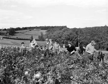
Photograph - Spykers family at Avonsleigh c.1960
Black and white photo showing a large family group in a flower field. In the background there are low hills with cleared paddocks and forested areas. According to the National Archives of Australia: 'Land was life for nurseryman Theo Spykers and his ancestors who had tilled the soil for generations; good land to own and to pass on to sons and their sons. At 42 Theo had one and a half acres near Rotterdam for a prosperous nursery, but he could only rent it and his family was growing. So, in 1948, Theo left his wife and six children at their home and set off by himself for Australia. Within a year he had paid a deposit on a broken-down property of 35 acres in the Dandenong ranges. His family joined him and they started to rehabilitate their new property. Mr and Mrs Spykers and twelve of their thirteen children pick chrysanthemums for sale in Melbourne, a city of 1,750,000. The children are; Theo, 20; Gerald, 15; Niko, 8; Frank, 5; Adolf, 22; Corrie, 11; Ria, 18; Terisa, 4; Anthony, 7; Tommy, 2; Elly, 10; Bill, 16.' Mr & Mrs Spykers are each holding one of the smaller children. This farm was on the corner of Birds Rd and Avon Rd, Avonsleigh. On the NAA records, Theodorus Gerardus Spykers arrived in Melbourne on the Muiderkerk on 27th February 1948. Black and white photo showing 15 year old Gerald Spykers carrying bundles of chrysanthemums tied ready for market. He is at the family farm on the corner of Birds Rd and Avon Rd, Avonsleigh. -
 Bendigo Historical Society Inc.
Document - BOARD OF WORKS, MELBOURNE: CONTRACTS ACCEPTED & LAND SALES FOR 1860
Page 2223 titled Contracts Accepted - (Series 1860). Contracts accepted are for Raising and removing sunken ship Marilla; Removal of Toll-gate from Mount Alexander Road and re-erection of same at Middle Gully; Erection of toll-house on Melbourne/Ballarat Road near Ballan; Erection of toll-house on Bendigo Road at Kangaroo Flat; Castlemaine to Ballarat - Erection of toll-house at Campbell's Creek; Construction of 2870 chains of Lower Western Road, west of Camperdown; Erection of two bridges and other improvements on the Clunes to Amherst Road; Erection of timber bridge, & c., over Two-mile Creek - Beechworth to Bowman Forest; Formation of roadway at head of Buckland Gap - Beechworth to Bowman Forest; Construction of culvert, & c., Rowe's Creek - Beechworth to Bowman Forest; Ararat and South-western sea-board road - erection of bridge over Dennicull Creek and other improvements. Land Sales - 4 Lots - Elsternwick, parish of Prahran, County of Bourke; 2 Lots - Dandenong, County of Bourke; 20 Lots - Lillydale, Parish of Yering, County of Evelyn, 1 suburban Lot - County of Evelyn, Parish of Yering; 1 Allotment - Romsey, County of Bourke, Parish of Lancefield; 5 Lots - County of Mornington, Parish of Langwarrin, and 2 Lots - County of Mornington, Parish of Fingal. Lots to be sold at the Auction Rooms of Mr. William Perry, Great Collins Street, Melbourne. A F A Greaves, President, Office of the Board of Land and Works, Melbourne.bridge, construction, timber bridges, board of works, melbourne - contracts accepted & land sales, 'marilla', f m pingree, jno r bailey, robert heron, john gray, donald ross, hector mclean, c j glynn and co, john nicholls and co, michael cleary, thomas cairncross, brown and gibson, queen victoria, mr william perry, mr de castella, willoughby, barker, a f a greeves, board of land and works melbourne -
 Ringwood and District Historical Society
Nurses case, Globe Goods, Nurse Maggs' case used in Ringwood in the early 1900s
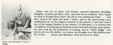
Marianne Hardridge married James Maggs and had 11 children. They began orcharding on Wonga Road when there was nothing but bush. Over the years it became one of the largest orchards, and they were also one of the largest families in the district. As well as helping on the land Marianne took up nursing and as Nurse Maggs brought over 500 children into the world in the Ringwood area. This was in the early 1900s when there was no doctor, no dentist, no hospital or chemist in the area.Nurses case containing black velvet cape, white apron, and measuring glass in box: Brown case with split opening lid revealing a 2 black velvet cape, with frilled edge, 3 white cotton apron, and 4 a small black box containing 5 a measuring glass +Additional Keywords: Maggs, James / Hardridge, MarianneOn case - Beatzall Cases Australia (manufacturers logo) Inside Hand written M.A.Maggs, Clive Street ,Mitcham -
 Eltham District Historical Society Inc
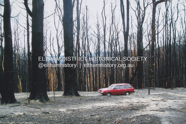
Photograph, Fay Bridge, Aftermath of the Black Saturday bushfire at Kinglake, c.May 2009
Australia's worst natural disaster, fed by extreme temperatures, tornado-like wind speeds and tinder-dry land, culminated in the disaster we now know as Black Saturday, February 7, 2009. Before the sun would set on the blackest day in Australia's history, thousands of hectares would become blackened landscape and an unparalleled loss of lives could only mean that many areas would never be the same again.fay bridge collection, black saturday, kinglake, victorian bushfires - 2009 -
Glen Eira Historical Society
Document - Bevan, James
Nine handwritten extracted pages from the diary (Letts?) of James Bevan, dated from 03/04/1863 to 21/11/1864. Writings mention his daily doing, the horses he rides, meetings he attends, land and paddocks he buys and details of money he spends including which race meetings he attends. Researched at Latrobe Library, MS9083 by unknown on 20/11/1975.bevan james, bevan mrs, caulfield, slaney’s paddock, caulfield racecourse, elections, racecourses, crawley’s paddock, st kilda park, slaney miss, horse racing, floods, racehorses, horses, hunting, wildlife, kennels, servants, coaches, coach builders, carriages, stables, diaries and journals -
 Eltham District Historical Society Inc
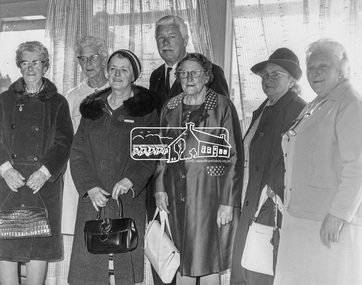
Photograph, His Excellency Major General Sir Rohan Delacombe with Lady members of the Shire of Eltham Elderly Citizens' Clubs, 19 September 1973
The State Governor Sir Rohan Delacombe and Lady Delacombe visited the Shire of Eltham where they were entertained to a civic luncheon by the Shire President Cr. L. E. Clarke and councilors at the Panton Hill hotel and made a tour of the shire. Among which was the Eltham elderly citizens' club where he met L-R: Mrs Lander, Mrs Stevenson, Mrs Armstrong, Mrs Norman, Mrs - , and Mrs Crockett. This photo forms part of a collection of photographs gathered by the Shire of Eltham for their centenary project book,"Pioneers and Painters: 100 years of the Shire of Eltham" by Alan Marshall (1971). The collection of over 500 images is held in partnership between Eltham District Historical Society and Yarra Plenty Regional Library (Eltham Library) and is now formally known as 'The Shire of Eltham Pioneers Photograph Collection.' It is significant in being the first community sourced collection representing the places and people of the Shire's first one hundred years.Digital imagemajor general sir rohan delacombe, mrs armstrong, mrs crockett, mrs lander, mrs norman, mrs stevenson, sepp, shire of eltham pioneers photograph collection, rohan delacombe, governor, visit, crockett, lander, sepp, senior citizens centre, seniors, older people, older women, stevenson, armstrong, shire of eltham pioneers photograph collection -
 Eltham District Historical Society Inc
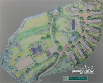
Drawing, Architectural Concept Plan: Kinloch Gardens proposed development, 93 Arthur Street, Eltham, 1997, 1997
Proposed design for Kinloch Gardens project with 12 sites illustrated plus Kinloch Main House. Ian Jelbart owned the entire Woodridge Estate but retained the top of the hill in Arthur Street until this development in 1997-1998, which he developed in conjunction with Graeme Gunn. Ian Jelbart inherited the land from his father who had purchased it cheap during the Great Depression. Kinloch is a castle in Scotland. Ink, wash and pencil on paper adhered to 13mm thick polyurethane boardKinloch Gardensarthur street, eltham, graeme gunn, ian jelbart, jelbart property, kinloch gardens -
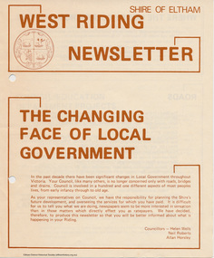 Eltham District Historical Society Inc
Newspaper - Folder, Shire of Eltham, West Riding Newsletter, 1978
Newsletter produced by the Shire of Eltham including introduction titled: "The changing face of local government", signed by Ward councillors: Helen Wells, Neil Roberts and Allan Horsley, a brief financial statement: "where the money comes from", roads, shopping centres, council/education department projects, land purchase, senior citizens and recreation include list of new construction and upgrades. Folder 71 from Harry Gilham Collection4 pages. Foldedallan horsley, community services, shire of eltham, budget, roads, shoppping centres, briar hill, montmorency, recreation, helen wells, neil roberts -
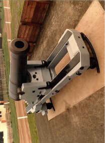 Glenelg Shire Council Cultural Collection
Photograph - Photograph - Battery Point, Portland, c. 1983
Glenelg Shire Council records. Built on land gazetted for defence purposes in the 1840s, Portland Battery was constructed in 1889 to defend Victoria against the feared Russian invasion. Batteries were also constructed at Warrnambool and Port Fairy during this period. The Battery comprises a magazine, upper chamber, a parapet wall, and three gun emplacements. In 1984 the Battery underwent a major restoration. The underground magazine and lamp passage are currently not accessible to the public.Picture of Cannon, Low Moore 68 lb, 1861, Battery Point, South Portland.portland battery, cannon, munition, fortifications, magazine, 1800s -
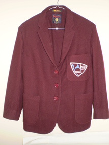 Greensborough Historical Society
Blazer, Watsonia High School Uniform - Blazer WaHIGH, 1985c
Blazer from Watsonia High School. The Watsonia High School and Watsonia Technical School were merged to form Greensborough Secondary College for the beginning of the 1990 school year, with the high school campus serving as a senior school for years 11 and 12, and the larger technical school used as a junior campus. It was renamed Greensborough College when the former high school campus was closed in 1992. This land was redeveloped into housing lots.This blazer is part of a small collection of Watsonia High School memorabilia.Blazers were Maroon in colour. Pocket Badge depicted the School Logo and motto "Nothing Without Labour". For standard uniform the thread was white and yellow thread for Prefects and included the word Prefect. watsonia high school, uniform, blazer, mina garment, doctor flannel, school uniform -
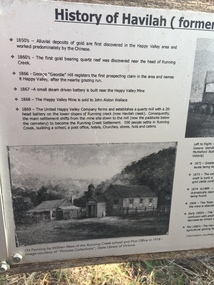 Kiewa Valley Historical Society
Papers - Havilah Cemetery, Havilah Cemetery Formerly Running Creek Cemetery
In 1889, 24 residents of the Running Creek and surrounding district submitted a petition to the Minister of Lands, Melbourne requesting land for a cemetery. Their request was granted. The Cemetery was decommissioned in the early 1950s and the last trustee for the cemetery died in 1986. There is a wooden fence around the boundary (May 2024). One paper lists 29 names in the Burial Register 1861-1948. The last two sheets record the history as a timeline from the 1850s to the 1900s. Havilah was a gold mining settlement from the 1850s located 20km west of the Kiewa Valley and in the Ovens catchment near Myrtleford.Five black and white A4 pages stapled together. Copies of the sign erected at the gate of 'Havilah cemetery formerly Running Creek Cemetery'. Also the 'History of Havilah formerly Running Creek'havilah, running creek, cemetery -
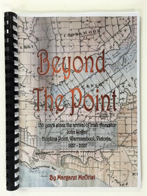 Warrnambool and District Historical Society Inc.
Booklet, Beyond the Point, 2007
This book was written in 2007 by Margaret McOrist to mark the 150th anniversary of the arrival in the Warrnambool area of John Logan. It is a sequel to a 1991 book, ‘Clotted Cream and Mangels’ which told the story of John Logan and his wife Mary Gardner. They lived at Hopkins Point, Warrnambool and the book, ‘Beyond the Point’ tells the story of the Logan descendants. When the farm land was sub-divided and sold the nearby beach was named ‘Logans Beach’. This book is of considerable interest as it tells the story of the descendants of important early settlers, John Logan and Mary Gardner. The area where they first settled is now of major interest as Logans Beach (named for the Logan family) is the well-known whale watching area. Southern Right Whales return to this beach each year and the females calve and remain up to three months at this beach, making it an important ‘whale nursery’. This is a soft cover book with black plastic ring binding and clear plastic sheets covering the front and back paper covers. The front cover has a reproduction of an 1891 map of Warrnambool and district with the title of the book and other information superimposed on the map. The back cover is black. The book has 101 pages and contains information on the Logan families who lived at Tooram in Allansford and their descendants. There are many black and white and colour photographs, diagrams, maps and family trees. Front Cover: ‘Beyond the Point, 150 years since the arrival of Irish ancestor, John Logan, Hopkins Point, Warrnambool, Victoria, 1857-2007, by Margaret McOrist’. john logan and mary gardner, hopkins point, logans beach, tooram, history of warrnambool -
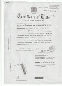 Port Melbourne Historical & Preservation Society
Document (Item), Certificate of Title 400 Williamstown Road, Port Melbourne, 9 Mar 1944
The Certificate of Title states that "Robert Fredrick WATTERS, Cartage Contractor and Ellen Mary WATTERS, Married Woman, both of 400 Williamstown Road, Garden City, Port Melbourne are now Joint Proprietors" of Garden City house & land on the corner of Williamstown and Beacon Roads. in 1963 Ellen became the Surviving Proprietor and 1966 the property passed to Ellen Patricia WATTERS and Norma Madeline WATTERS. Norma was registered as the Surviving Proprietor in 1984. built environment - domestic, garden city, robert fredrick watters, ellen mary watters, ellen patricia watters, norma madeline watters, williamstown road -
 Mt Dandenong & District Historical Society Inc.
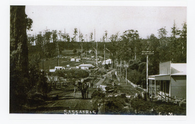
Photograph, Sassafras, c1915
The south end of Sassafras Main Street outside the Big Store (Sherrards), built in 1912 that sold a bit of everything. The early settler Arthur Goode, who arrived in 1893, originally owned the land. Arthur Goode ran the Post Office in a bark hut until he moved away in 1911. From 1912 the Post Office operated from a room in Hinkley Guest House from 1912 until 1937.Black and white copy of a GGM photograph of Sassafras. A man driving a horse and cart is coming up the road towards the camera while several couples can be seen strolling down the road. The early buildings of Sassafras are clearly visible.sherrards, sassafras, arthur goode, goode, hinkley, post office -
 Kew Historical Society Inc
Plan - Subdivision Plan, Kew Golf Links Estate, 1936, 1936
The Kew Golf Links Estate was a major subdivision in North Kew. It derived its title due to the land being previously occupied by the Kew Golf Club, which transferred its course to a number of locations before occupying its current site. The Plan advertises 180 choice home sites. The street names are somewhat different today as those on the map are named after the proposed Kodak Factory to be built on the site. The subdivision of the Kew Golf Links Estate was a major subdivision of farmland in Kew. The site was at one stage designated for industrial development and the building of a new Kodak factory. The decision by Council to oppose the redevelopment makes the beginning of the period when all industrial development was banned in Kew.Monochrome printed, folded subdivision plan for the Kew Golf Links Estate, to be auctioned on 7 November 1936. Streets named include: Carnegie Avenue, Willsmere Road, Kilby Boulevarde, Kodak Avenue, Coleman Avenue, Beresford Avenue, McConchie Avenue, Cole Avenue, White Avenue, Baker Avenue, Spruzen Avenue, Tanner Avenue, Ratten Avenue, Mathers Avenue, Railway Avenue, Sutherland Avenue, and Belford Road. The position of the Yarra River and a large Drainage Reserve are marked on the plan. Lots for sale are numbered. Existing buildings are designated with a square.subdivision plans - kew (vic), kodak factory - kew (vic) -
 Sunbury Family History and Heritage Society Inc.
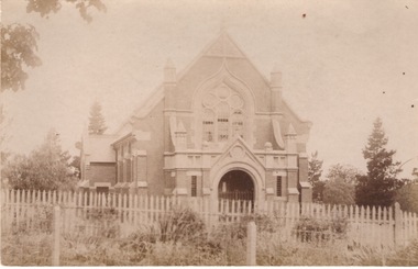
Photograph, St. Andrew's Presbyterian Church
The Government first granted land for the building of a Presbyterian Church in Sunbury in Stawell Street and Barkly Street, in 1864 and a smaller building was later erected on the site. In 1904 Rev Goyen pressed for a brick church rep[lace the smaller weather board building and the foundation stone was laid for the new church was laid by Mrs. John Duncan on 17th August 1904 and the new church opened by Lady Clarke on 13th November 1904.The Presbyterian Church was one of the earliest churches to be established in Sunbury along with a school.A non-digital sepia photograph in post card format of the front view of a brick church with a light picket fence across the front. -
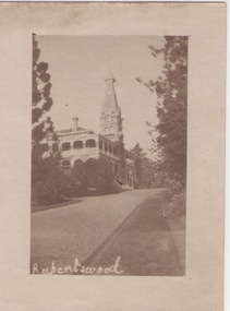 Sunbury Family History and Heritage Society Inc.
Photograph
Rupertswood Mansion was the Sunbury residence of the Clarke family from 1874 until 1922 when H.V.McKay of Sunshine Harvester fame bought it from Hon. W.L. Russell Clarke in 1922. After the death of H.V.McKay in 1926, it was purchased by W. Naughton who then sold the mansion and 700 acres of land to the Salesian Fathers, who are the present owners. It is now the site of Salesian College, a Catholic co-educational college fore secondary students.Rupertswood Mansion has had close social, spiritual and educational links with Sunbury's development since 1874.A small sepia photograph with a cream frame of a driveway leading to a large mansion. 'RUPERTSWOOD' written in the LH corner of the photograph.rupertswood mansion, clarke, w.j.t., mckay, h.v., salesian college -
 City of Greater Bendigo - Civic Collection
Instrument - Gunter Chain, not known
Gunter's chain (also known as Gunter’s measurement) is a distance measuring device used for surveying. It was designed and introduced in 1620 by English clergyman and mathematician Edmund Gunter (1581–1626). It enabled plots of land to be accurately surveyed and plotted, for legal and commercial purposes. The provenance of this particular Gunter Chain is unknown but it is believed to be used either by the City of Bendigo / Sandhurst or the Lands Department locally when measuring and laying out plots and streets locally. A 66-foot (20.1 m) chain divided into 100 links, marked off into groups of 10 by brass rings or tags. Each link is 7.92 inches (201 mm) long. A quarter chain, or 25 links, measures 16 feet 6 inches (5.03 m) also called a a rod (or pole) measure. Ten chains measure a furlong and 80 chains measure a statute mile. city of greater bendigo surveying -
 Bendigo Military Museum
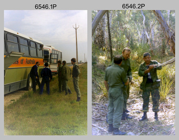
Photograph - 4th Field Survey Squadron Adventurous Training Mount Remarkable National Park, SA, 4th Field Survey Squadron Adventurous Training, Mount Remarkable National Park, SA, 1987
This is a set of 42 photographs of 4th Field Survey Squadron undergoing adventurous training at Mount Remarkable National Park, South Australia in May 1987. It is evident the training focussed on teamwork, leadership, abseiling, rock climbing, field craft and living off the land survival skills. Elements from units of the Army Reserve also participated in the training. Refer to items 6547.40P and 6548.14P for additional photographs taken during the adventurous training.This is a set of 42 photographs of 4th Field Survey Squadron undergoing adventurous training at Mount Remarkable National Park in May 1987. The colour photographs are on 35mm negative film and are part of the Army Survey Regiment’s Collection. The photographs were scanned at 96 dpi. .1) - Photo, colour, 1987. L to R: unidentified bus drivers, CAPT Danny Galbraith, unidentified, SGT Stu Symonds. .2) - Photo, colour, 1987. L to R: OC MAJ Peter Cates, SSM WO1 Bill Grigg, unidentified exchange officer. .3) - Photo, colour, 1987. Squadron briefing. .4) - Photo, colour, 1987. Endurance march L to R: unidentified (x4), LCPL Peter McCurdy, unidentified (x3), SPR Damien Killeen, unidentified. .5) - Photo, colour, 1987. Unidentified personnel taking a break during or at end Endurance march. SPR John Keely at far right. .6) - Photo, colour, 1987. Mount Remarkable National Park terrain. .7) - Photo, colour, 1987. Mount Remarkable National Park terrain. SGT Peter Imeson. .8) - Photo, colour, 1987. Mount Remarkable National Park terrain. CPL Jeff Prince. .9) - Photo, colour, 1987. Camp activities. CPL Dave Irving. .10) - Photo, colour, 1987. Camp activities. L to R: unidentified, SPR Perry Langeberg, unidentified (x2), CPL Neale ‘Tex’ Houston, SPR Steve Ellis. .11) to .13) - Photo, colour, 1987. Mount Remarkable National Park terrain. .14) - Photo, colour, 1987. Camp activities. Unidentified. .15) - Photo, colour, 1987. Camp activities. L to R: PTE P. Simpson, SPR Steve Ellis. .16) - Photo, colour, 1987. Hootchie set-up. Unidentified personnel. .17) - Photo, colour, 1987. Hootchie set-up. .18) - Photo, colour, 1987. Camp activities. Unidentified. .19) - Photo, colour, 1987. Camp activities. L to R: SPR Todd Hayley, CPL Jamie McRae. .20) - Photo, colour, 1987. Camp activities. L to R: unidentified, CPL Neale ‘Tex’ Houston, unidentified. .21) - Photo, colour, 1987. Camp activities. L to R: CPL Dave Longbottom, WO2 Brett ‘Dutchy’ Van Leeuwen. .22) - Photo, colour, 1987. Hootchie set-up. .23) - Photo, colour, 1987. Hootchie set-up. CPL Dave Irving. .24) - Photo, colour, 1987. Mount Remarkable National Park terrain. Possibly OC MAJ Peter Cates. .25) - Photo, colour, 1987. Mount Remarkable National Park terrain. .26) & .27) - Photo, colour, 1987. Hootchie set-up. .28) - Photo, colour, 1987. Camp activities. CPL Roger Graf. .29) - Photo, colour, 1987. Camp activities. Possibly water sterilisation. .30) - Photo, colour, 1987. Camp set-up. Unidentified. .31) - Photo, colour, 1987. Hootchie interior. .32) - Photo, colour, 1987. CAPT Danny Galbraith. .33) - Photo, colour, 1987. Camp activities. L to R: LCPL Peter Tuddenham, SPR Todd Hayley, CPL Dave Longbottom, CPL John Ratcliffe, CPL Dave Irving. .34) - Photo, colour, 1987. Hootchie set-up. .35) - Photo, colour, 1987. Hootchie set-up. CPL Peter Hardy. .36) - Photo, colour, 1987. Camp activities. L to R: unidentified (x2), CPL Peter Hardy, LT Greg Oaten. .37) - Photo, colour, 1987. Camp activities. L to R: SPR Shaun Hynes, LT Geoff ‘GT’ Ford, SPR Bruce Graham, unidentified (x2). .38) - Photo, colour, 1987. Camp activities. L to R: SPR Shaun Hynes, LT Geoff ‘GT’ Ford, unidentified, SPR Bruce Graham, in background - CPL Dave Irving. .39) - Photo, colour, 1987. Hootchie set-up. Unidentified. .40) - Photo, colour, 1987. Camp activities. WO2 Brett ‘Dutchy’ Van Leeuwen. .41) & .42) - Photo, colour, 1987. Camp activities. Results from foraging the forest for food..1P to .42P – There are no personnel identified. ‘1987 ADV TRAINING’ annotated on negatives sleeve.royal australian survey corps, rasvy, 4 fd svy sqn -
 Bendigo Military Museum
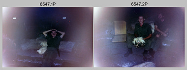
Photograph - 4th Field Survey Squadron Adventurous Training, Mount Remarkable National Park, Flinders Ranges, SA, 4th Field Survey Squadron Adventurous Training, Mount Remarkable National Park, SA, 1987
This is a set of 40 photographs of 4th Field Survey Squadron undergoing adventurous training at Mount Remarkable National Park, South Australia in May 1987. It is evident the training focussed on teamwork, leadership, abseiling, rock climbing, field craft and living off the land survival skills. Elements from units of the Army Reserve also participated in the training. Refer to items 6546.42P and 6548.14P for additional photographs taken during the adventurous training.This is a set of 40 photographs of 4th Field Survey Squadron undergoing adventurous training at Mount Remarkable National Park, South Australia in May 1987. The colour photographs are on 35mm negative film and are part of the Army Survey Regiment’s Collection. The photographs were scanned at 96 dpi. .1) - Photo, colour, 1987. Camp activities, unidentified soldier. .2) - Photo, colour, 1987. Camp activities, unidentified personnel. .3) & .4) - Photo, colour, 1987. Hootchie set-up. .5) - Photo, colour, 1987. Camp activities, unidentified personnel. .6) - Photo, colour, 1987. Hootchie set-up. .7) - Photo, colour, 1987. Camp activities. .8) - Photo, colour, 1987. Hootchie set-up, unidentified officer. .9) - Photo, colour, 1987. Camp activities. Results from foraging the forest for food. .10) - Photo, colour, 1987. Camp set-up. .11) - Photo, colour, 1987. Camp activities. .12) - Photo, colour, 1987. Camp activities. L to R: CPL Jeff Prince, unidentified (x3). .13) to .16) - Photo, colour, 1987. Camp activities. .17) & .18) - Photo, colour, 1987. Mount Remarkable National Park terrain. .19) - Photo, colour, 1987. Hootchie set-up. L to R: unidentified, CPL Jeff Prince, SPR Perry Langeberg, unidentified (x3). .20) - Photo, colour, 1987. Camp activities. .21) - Photo, colour, 1987. Camp activities, unidentified personnel. .22) & .23) - Photo, colour, 1987. Camp set-up. .24) - Photo, colour, 1987. Hootchie set-up. .25) - Photo, colour, 1987. Hootchie set-up, unidentified personnel. .26) - Photo, colour, 1987. Camp activities. L to R: CPL Jeff Prince, SPR Steve Ellis, SGT Peter Imeson, CPL Neale ‘Tex’ Houston, SPR Perry Langeberg, unidentified exchange officer, WO2 Russ Larsen. .27) - Photo, colour, 1987. Hootchie set-up. .28) - Photo, colour, 1987. Camp activities. L to R: SPR Bruce Graham, LT Geoff ‘GT’ Ford, CPL Jamie ‘Fish’ McRae, SGT Wally Chilcott, SPR Shaun Hynes, CPL Kevin Whitty. .29) - Photo, colour, 1987. Camp activities. L to R: unidentified, SPR Todd Hayley, unidentified, WO2 Peter Symmans, SSGT Cam Chapman, CPL Dave Irving. .30) - Photo, colour, 1987. Camp activities. L to R: unidentified (x2), LT Greg Oaten, unidentified (x2), CPL Peter Hardy, unidentified. .31) - Photo, colour, 1987. Camp activities. L to R: CPL Roger Graf, WO2 Bob Rogister, SSM WO1 Bill Griggs, unidentified officer, SPR Simon Reynolds, SPR John Keely. .32) - Photo, colour, 1987. Camp activities. L to R: unidentified, SPR Steve Nokes, SGT Stu Symonds, WO2 Brett ‘Dutchy’ Van Leeuwen, unidentified (x3). .33) - Photo, colour, 1987. Camp activities. L to R: unidentified, SGT Derek Stanmore, CAPT Danny Galbraith, unidentified in foreground. .34) - Photo, colour, 1987. Camp activities. L to R: unidentified (x3), SGT Derek Stanmore, CAPT Danny Galbraith. .35) - Photo, colour, 1987. Camp activities. .36) - Photo, colour, 1987. Camp activities. OC MAJ Peter Cates. .37) - Photo, colour, 1987. Camp activities. L to R: unidentified, CPL Dave Longbottom. .38) - Photo, colour, 1987. Camp activities, unidentified personnel. .39) & .40) - Hootchie set-up..1P to .40P – There are no personnel identified. ‘1987 ADV TRAINING’ annotated on negatives sleeve.royal australian survey corps, rasvy, 4 fd svy sqn -
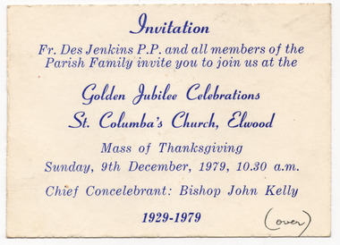 St Kilda Historical Society
Ephemera - Invitation, Golden Jubilee Celebrations, St Columba's Church, Elwood, 1979
Invitation to a Mass of Thanksgiving in connection with the Golden Jubilee Celebrations of St Columba's Church, Elwood, on 9 December 1979. The St Columba Church and school is on the corner of Glenhuntly Road and Normandy Road, Elwood. The land was purchased in 1914. The school was built and opened first in 1918 and the church was completed and opened in 1929. The church is now part of the Catholic Parish of Sacred Heart and St Columba, serving St Kilda and Elwood communities.White card, discoloured with age, printed in blue on one side. Handwriting on both sides, in blue and blackHandwriting on back in black: Dearest Joan, This is our warm invitation, do hope you can come Mary. Handwriting on back in blue: Please come to the "Back to" in Parish Hall after Mass.churches, st columba's church, elwood -
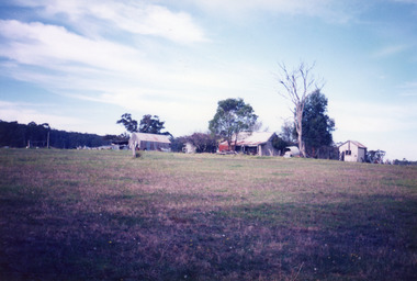 Lakes Entrance Historical Society
Photograph - Historic House, Bennett, Vera, 1991
Date made May 1991|Old building demolished c2008. Ostler family arrived at Cunninghame (Lakes Entrance) by boat, walked to the site with their belongings, cleared the land, built a dwelling, farmed dairy herd, grew maize, had beehives.| Also one colour photograph of new dwelling constructed next to the old dwelling taken 29th September 2007|Also two other colour photographs old dwelling.Colour photograph of Ostlers old home, 106 Ostlers Road, showing a timber and corrugated iron structure amongst farm buildings and trees. Lakes Entrance Victoriahouses, local history -
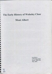 Surrey Hills Historical Society Collection
Book, The early history of Wolseley Close, Mont Albert, 2010
Includes copy of will of William Clark. Resident of the property at 9 Wolseley Close in 1910. Includes copy of the Alan Holts home occupier / tenant records - names from 1920 - 1980. Includes photo of Wolseley Close house, taken 1888/1889 plus colour photo of Wolseley Close house taken by Lin Merry, 2010. Land Title information, surveys, subdivision Includes list of occupants of the house, p.17Includes some plans of houses built in Wolseley Close, Mont Albert, Victoria. Outlines details of property at 9 Wolseley Close19p : col illcragg family, windsor crescent, surrey hills, (mr) william ainger, (mr) isaiah ainger, whitehorse road, noorn hill, house names, koonda, d j maloney, (mrs) louisa clara maggs, taramera, union road, st.abbs, york street, (mr) william henry cleverdon, wolseley street, windsor park estate, tarawera, merry family, clinton family, adams family, tel-el-kebir, farrell family, (mr) william clark, trafalgar street, (mr) (sir) matthew davies, (mr) c h james, (mr) james munro, (mrs) elizabeth clark, langdale, (mr) stanley dewar, (mr) john jose, (mrs) emily hampton, potton, (mr) alexander potton, (mr) john atkinson morris, freehold investment & banking co., mont albert, windsor park surrey hills, dalton family, (mr) henry wood, wolseley close -
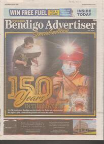 Bendigo Historical Society Inc.
Newspaper - Articles on the 150 years History of Bendigo, Sat July 17 2021
Mayor Jennifer Aiden acknowledged that Greater Bendigo has become a 'thriving', vibrant regional city. The mayor listed the achievements of the city since the discovery of gold change the landscape from that of pastoral. In the other article along with a photo of the fountain, the story relates the history since 1836 when Major Mitchell passed through the central Vicotorian region as one of the first Europeans to walk upon the Dja Dja Wurrung's land.Bendigo Advertiser Two page of articles '150 years in the making'. The article acknowledges the region's past, celebrates the present and looks to the future.'bendigo history -
Eltham District Historical Society Inc
Document - Folder, Smith, Edwin
Samuel Smith settled in Queenstown, now St Andrews, in 1854. His son Edwin Smith took land in Panton Hill in 1871 and family lived at "Beaumont", Cherry Tree Road, Panton Hill in 1894. Contents Photocopy of photograph: Mr and Mrs Edwin Smith and Family. Newspaper article: "Milestone for Smith family", Leader Associated Newspapers Eltham Centenary Supplement, 30 March 1971. History of Smith family. Newspaper clippings, A4 photocopies, etcedwin smith, beaumont cherry tree road panton hill, alice cracknell nee smith, victor smith, rose white nee smith, may jones nee smith, bert smith, will smith, george smith, samuel smith, queenstown now st andrews, lloyd smith, heidelberg travel service, motschall orchards, smiths gully, alfred smith, florry scarse nee smith -
 Federation University Historical Collection
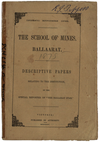
Booklet, The School of Mines Ballaarat: Descriptive papers relating to the institution by the special reporter of "The Ballarat Star", 1875 (exact)
The booklet comprises of a series of papers published in the Ballarat Star, with some revisions. The Administrative Council hoped the publication would increase interest in Technical Education, especially the Art of Mining. He would also hope the public would recognise the Ballarat School of Mines as an institution adapted to supply technical education. The Ballarat School of Mines Council listed at the front of the book includes: Redmond Barry (President and Trustee), Judge Rogers (Vice-President), Somerville Livingstone Learmonth (Trustee), Rivett Henry Bland (Trustee), Charles Gavan Duffy, John A. MacPherson (MLA), William McLellan (MLA), Duncan Gillies (MLA), F. McCoy (University of Melbourne), John I. Bleasdale, W.H. Barnard, James M. Bickett, Henry Richards Caselli, P. Chauncy, J.M. Davey, Joseph Flude, R.F. Hudson, Robert Lewis, James Oddie, Robert M. Serjeant, J. F. Usher, John Walker, J. Williamson, Mayor of the City of Ballaarat, chairman (for the time being) of each of the seven Mining Boards of Victoria. The President of Examiners was Judge Rogers, and the Honorary Auditor was Richard Ford.Stapled, brown soft covered booklet of 48 pages. Section I outlines the establishment of the Ballarat School of Mines, the buildings and land used by the school, describes in detail the former Ballarat Circuit Court and describes the lecture rooms. Section II describes the Ballarat School of Mines Museum, including a description of exhibits. Section III describes the lecture hall, and the apartments on either side of the hall, including the office of the registrar W.H. Barnard, mathematical classroom, chemical laboratory, and metallurgical laboratory. Section IV outlines the subjects offered by the Ballarat School of Mines, including Mathematics taught by John Victor of Grenville College, who had been educated at Trinity College Dublin. Mining and Land Surveying was taught by C.W. Thomas. Mr Croll taught mechanical drawing, followed by Jonathan Robinson of the Union Foundry, and finally S. Keast. It then lists some text books used in the school. Section V mentions the School Council, lack of funds, future directions, mining laboratory. Vi- Describes the land and out buildings, and the proposed building for metal and wood turning, brass foundry, blacksmith, working engine, etc. This section describes some large donations to the school - 50 pounds from the Misses Meglin of Melbourne, 10 pounds 10 shillings to the 'Pyrites fund' by the Walhalla and Long Tunnel Companies in Gippsland. Section VII covers the teaching of chemistry by Joseph Flude. Section VIII outlines the metallurgy classes and the process of assaying. Section IX covers telegraphy taught by Mr Bechervaise Section X describes the examination process at the Ballarat School of Mines. Examiners in mathematics were G.J. Russell (Buninyong) and John Lynch (Smythesdale), mining and land surveying John Lynch and P.C. Fitzpatrick (Ballarat), Principles and Practice of Mining R.M. Serjeant (Band and Albion Consols), Mechanical Engineering John Lewis (New North Company Clunes, Mineralogy and Geology G.H. F. Ulrich, Assayign and Chemistry J. Cosmo Newberry, and Telegraphy R.L.J. Ellery (government astronomer) and Sam W. Macgowan. Underground managers and captains in quart mining was examined by Henry Rosales (Walhalla Company), and alluvial mines by Messrs Bockett, Kent, Martin and Mitchell. Engineers and Engine driving was examined by W.H. Keast,Peter Matthews, Jonathan Robinson and J.M. Troup. Section XI - Covers Annual reports of the school, and honorary correspondents of the school including: John Day (Geelong); R. Evan Day (London); W.W. Evans, M.J.C.E. of New York; J.Y. Fishburne, M.B. of Ararat; Felice Giordano, Inspector of Mines, Italy; Julius Von Haast, Ph. D.F.R.S., Government Geologist of Canterbury; James Hector, M.D., F.R.S., Government Geologist of Wellington, New Zealand, W.F. Hopkins (Grant); Charles A. La Trobe, C.E. (Engineer-in-Chief International Railway Plant, London); Archibald Liversidge, F.G.S. (Professor of Mineralogy and Reader in geology at Sydney University; J.J. Macgregor, M.D. (Creswick); J.T. McKenna (1st class of SMB underground management - Northern Territory); Henry Rosales, M.E. and M. (Walhalla); Harrie Wood (SMB founder and Under-secretary for Mines, Sydney); John Walthew (Stockport, England) .2) Signed 'E.J. Tippett', former President of the Ballarat School of Mines Council melbourne, mla, ballarat school of mines, redmond barry, j f usher, james bickett, w f hopkins, rivett henry bland, s m b, judge rogers, somerville learmonth, charles gavan duffy, gavan duffy, john macpherson, william mclellan, duncan gillies, f mccoy, university, john bleasdale, henry richards caselli, henry caselli, p chauncy, j m davey, joseph flude, r f hudson, robert lewis, james oddie, robert m serjeant, john walker, j williamson, richard ford, ballarat court house, assay, john victor, grenville college, trinity college dublin, c w thomas, jonathan robinson, union foundry, s keast, blessdale, john day, r evan day, w w evans, j y fishburne, felice giordano, julius von haast, james hector, charles a la, trobe, archibald liversidge, j j macgregor, j t mckenna, henry rosales, harrie wood, john walthew, fees, frederick mccoy, w.h. barnard -
 Federation University Historical Collection
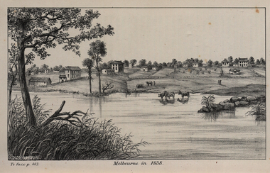
Image, John Helder Wedge, Melbourne in 1838, 1938
The following information is from http://melbourneday.com.au/about.html, accessed 30 August 2016 Melbourne was founded on 30 August 1835 by settlers who sailed from Van Diemen’s Land (Tasmania) aboard the schooner Enterprize. They landed on the north bank of the Yarra River and established the first permanent settlement, close to where the Immigration Museum at the Old Customs House — on the corner of William and Flinders Streets — stands and the place today known as Enterprize Park. Melbourne Day Committee was established to help correct the record about the founding of Melbourne and celebrate its anniversaries. The settlers came from Launceston in search of sheep-grazing land. Land had become expensive and there had long been stories told by whalers and sealers working in Bass Strait of fertile land to the north. This was the southern part of the colony of New South Wales, which the Colonial Government did not want settled at that time. After the Henty family crossed Bass Strait and settled at Portland in 1834 others quickly followed. The north bank was chosen because a small waterfall, or rapids, stopped further progress up the river. The waterfall also separated the tidal movement, providing a vital supply of fresh water. The site had previously been noted by the colony of New South Wales' surveyor, Charles Grimes, in 1803. The north bank also offered more stable, suitable ground. The people of the Kulin nation are the traditional owners of the land that became Melbourne — including the Boonwurrung, Woiwurrung, Taungurung and Djadjawurrung people, who gathered in this place for ceremonies and cultural activities. The topsail schooner Enterprize you see today is a full-size replica of the one that brought the settlers and has become a symbol of Melbourne Day. Her keel was laid at Polly Woodside Maritime Museum in 1991, and the $2.5 million, 27m vessel was launched by Felicity Kennett on 30 August, 1997, at Hobsons Bay. The original ship was bought by John Pascoe Fawkner in April 1835 specifically to search for a suitable place for a settlement in the Port Phillip District. After helping establish Melbourne, the original Enterprize continued operating as a coastal trading vessel for a number of years. She eventually disappeared off the shipping register in 1847, having been wrecked on a sand bar in the Richmond River in northern NSW, with the loss of two lives. The replica is managed by the Enterprize Ship Trust, a not-for-profit organisation. The first settlers were those on board the Enterprize — her crew and passengers. They were John Lancey , master mariner and Fawkner’s representative; Enterprize's captain, Peter Hunter; George Evans, plasterer/builder; carpenters William Jackson and Robert Hay Marr; Evan Evans, George Evans’ servant; and Fawkner’s servants ploughman Charles Wise, general servant Thomas Morgan, blacksmith James Gilbert and his pregnant wife, Mary. And Mary's cat! Enterprize set sail on her historic voyage from Launceston on July 21, 1835, stopping at George Town in northern Tasmania where creditors detained Fawkner. He was therefore not part of the first trip to Melbourne. Enterprize then left on August 1 under the command of captain Hunter. The expedition was led by Lancey, Fawkner's delegate. The party first considered Western Port and the eastern side of Port Phillip for a place to settle, before deciding on the Yarra’s north bank — known today as Enterprize Park. On Sunday, August 30, they disembarked and began to erect shelter, build a store and clear land to grow food, thus starting the permanent European settlement of Melbourne.Image of the fledgling town of Melbourne on the banks of the Yarra River. melbourne, yarra river, john helder wedge