Showing 8340 items matching "watering"
-
 Kiewa Valley Historical Society
Photographs – Set of 10 black and white photographs and photocopies of original photographs documenting early residents of Bogong Village
Bogong Village, which was known as “The Junction”, is well recorded. The first tent camp was at the junction of Pretty Valley and Rocky Valley streams in the early 40’s. Further downstream were the sawmill, stables and blacksmith’s forge. Horses were the main mode of transport in the early days. The road to Bogong had reached the lookout spur just beyond Roper’s Spur track just before the 1939 fires. The early forties saw rapid growth of the village, with single and married men’s quarters, workshops, mess huts and administrative offices. The facilities necessary for communal living were quickly in place- a post office, police station, co-op store, medical centre, community hall/theatre, tennis courts and school. Much of the temporary accommodation that housed groups such as the Albion Quarrying Company were in the area now under water.This group of photographs are a pictorial record of the early history of the Kiewa Hydro Scheme, the people who worked in the background supplying administrative support and the workers and their families. It also shows a glimpse into how a large group of people from very diverse backgrounds came together to enjoy social activities and share each others companyGroup of 10 black and white photographs and photocopies of original photographs of varying sizes (some official SECV photos) Some Photos are labelled with the date and the names of SECV staff members. Depicting early life at Bogong Village 1. Group photo – Kiewa House Residents 1.8.41 (SECV official photo) 2. Female staff residents 3. Female office staff 4. Kitchen staff – Junction Mess (SECV official photo) 5. Male administration staff Bogong 6. Bogong Social Club fancy dress ball, 1940 7. Wives and children of SECV workers 8. Children in fancy dress 9. Opening of Volunteer Air Observers post 1943 10. Flag raising at opening of Volunteer Air Observers post 1. Printed under photo: STATE ELECTRICITY COMMISSION OF VICTORIA Date: 1.8.41 Time: 12.30pm No:K 435 Kiewa Hydro-Electric Works. Kiewa House Residents Back Row L to R: S.A. Salmon, W. Strachn, T.A Connors, W.J Norman, R.C Grealey, R.D Hegarty, Mrs Hegarty, W.R Morgan, S.A Clarke, P. Morgan, P.J. Harnetty, G.W Crouch. Front Row L to R: W.L Godfrey, R.S Hollands, Pte. R Charlesworth, R.L Dunn, N Caldwell, L.T Davies, I Webber, H.L Kendall, P Tiller, Ricky Hegarty, L.T Guy, M.C Cox, K.F Calder, D.S Gibson 2. Printed on bottom: Staff who lived at Kiewa House and worked in the Administration Office c 1943 Handwritten at bottom Priscilla Johnson (nee Reid) At top of page A GOOD LIFE: WOMEN’S RECOLLECTIONS OF LIFE IN THE UPPER KIEWA VALLEY 3. Printed under photo- Office Staff – Bogong 4. Printed under photo: STATE ELECTRICITY COMMISSION OF VICTORIA Date: 18.5.40 Time: 11.05am No:K 103. Kiewa Hydro-Electric Works. Kitchen Staff- Junction Mess. Opening night of the new staff mess Bogong. 5. Printed under photo -Administration staff Bogong 6. Printed under photo- The social club raised money for patriotic fund from fancy dress nights. (1st Fancy Dress Ball, Bogong 1940) 7. Printed above photo: ---- and family life begins (1942 Bogong) 8. Printed under photo: A favourite photograph 9. Printed under photo: STATE ELECTRICITY COMMISSION OF VICTORIA Date: 24.5.43 Time: 2.8pm No:K 1151 Kiewa Hydro-Electric Works. Bogong- Squadron Leader Leggett speaking at opening of Air Observer’s Post 10. Printed under photo: Raising the flag at the opening of the Volunteer Air Observer’s Post at Bogong - 1943 bogong village; kiewa hydro electric scheme; social activities; community clubs -
 Kiewa Valley Historical Society
Photographs – Set of 9 black and white photographs and photocopies of original photographs depicting the early days of Bogong Village during the 1940’s, circa 1940's
Bogong Village, which was known as “The Junction”, is well recorded. The first tent camp was at the junction of Pretty Valley and Rocky Valley streams in the early 40’s. Further downstream were the sawmill, stables and blacksmith’s forge. Horses were the main mode of transport in the early days. The road to Bogong had reached the lookout spur just beyond Roper’s Spur track just before the 1939 fires. The early forties saw rapid growth of the village, with single and married men’s quarters, workshops, mess huts and administrative offices. The facilities necessary for communal living were quickly in place- a post office, police station, co-op store, medical centre, community hall/theatre, tennis courts and school. Much of the temporary accommodation that housed groups such as the Albion Quarrying Company were in the area now under water.Pictorial history of the early years of Bogong Village including one photo taken following the devastating fires of 1939. Photos show the terrain in which Bogong Village was built, the early construction used for the temporary buildings and the housing and the amount of infrastructure required to accommodate the needs of the residents of the area including workers, their families and other support staff. Set of 9 black and white photographs and photocopies of photographs depicting early buildings at Bogong Village . Photos show very early construction buildings as well as the village in various weather conditions, including snowing and after bush fires. (some official SECV photographs) 1. Bogong Village in heavy snow 2. Bogong Township during heavy snow (SECV Official Photo) 3. VIP Lodge at Bogong in the snow 4. Bogong Village - circa 1940’s 5. Bogong Village under street lights 6. Lewis Construction Camp (SECV Official Photo) 7. Albion Quarrying Co. Camp (SECV Official Photo) 8. Tent camp and early buildings following 1939 fires 9. Typical house – Bogong Village 1. Handwritten under photo – August 1948 2. Printed under photo: STATE ELECTRICITY COMMISSION OF VICTORIA Date: 25.8.48 Time: 9am No:K 4680 Kiewa Hydro-Electric Works. Bogong Township 3. Handwritten on back of photo- V.I.P. Lodge, Bogong 4 – 5. No markings 6. Printed under photo: STATE ELECTRICITY COMMISSION OF VICTORIA Date: 28.11.40 Time: 1.40pm No:K284 Kiewa Hydro-Electric Works. Lewis Construction Camp 7. Printed under photo: STATE ELECTRICITY COMMISSION OF VICTORIA Date: 11.1.41 Time: 10.40am No:K294 Kiewa Hydro-Electric Works. Albion Quarrying Co. Camp – Bogong. Handwritten on back of photo: On the floor of the present dam 8. No markings 9. Printed under photo: STATE ELECTRICITY COMMISSION OF VICTORIA Date: 11.1.46 Time: 1.23pm No:K2181 Kiewa Hydro-Electric Works. Bogong – Typical House bogong village; 1939 fires; kiewa hydro electric scheme; -
 Kiewa Valley Historical Society
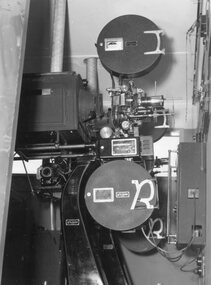
Photograph – Black and white photograph of an unidentified piece of equipment (possibly projection equipment) presumably used by SECV Hydro
The Victorian Government took control of power generation in 1921, forming the State Electricity Commission (SEC). Construction approval on a grand scheme to build five power stations with a combined capacity of 289 megawatts was received in 1938, and the Clover Power Station was completed by 1945. The original scheme was dramatically pruned after World War II and only two more power stations were built. The Junction Dam and Clover Dam Power Station, stages of the Kiewa Hydro-Electric Scheme, were needed to meet the increased power demands of the wartime industry in Victoria. Clover added 26 megawatts to the grid. Junction Dam was completed and ready to hold water by September 1943, but was emptied in December 1943 and not filled again until May 1944. Construction of Clover Power Station commenced in July 1941 and both turbines were in service by May 1945.Clover Power Station and Junction Dam were part of the Kiewa Hydro Electric Scheme constructed by the State Electricity Commission of Victoria.Black and white photograph of an unidentified piece of equipment (possibly projection equipment) presumed to be used in one of the power stations ie: Clover Power Station or Junction Dam as part of the Kiewa Hydro Electric Schemeprojection equipment; -
 Marysville & District Historical Society
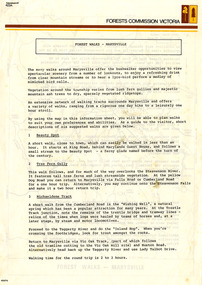
Flyer (Item) - Information Flyer, Forests Commission, Victoria, FOREST WALKS - MARYSVILLE, 1918-1983
An information flyer that was produced as a guide to the forest walks in and near Marysville by the Forests Commission of Victoria. The Forests Commission Victoria (FCV) was the main government authority responsible for management and protection of State forests in Victoria, Australia between 1918 and 1983. The Commission was responsible for ″forest policy, prevention and suppression of bushfires, issuing leases and licences, planting and thinning of forests, the development of plantations, reforestation, nurseries, forestry education, the development of commercial timber harvesting and marketing of produce, building and maintaining forest roads, provision of recreation facilities, protection of water, soils and wildlife, forest research and making recommendations on the acquisition or alienation of land for forest purposes″. An extensive network of walking tracks surrounds Marysville and they offer a variety of walks ranging in various levels of difficulty. This information flyer provides information such as the level of difficulty for six suggested walks around Marysville.An information flyer that was produced as a guide to the forest walks in and near Marysville by the Forests Commission of Victoria.marysville, victoria, australia, forest walks, forests commission victoria, beauty spot walk, tree fern gully walk, michaeldene track, keppel track, woods lookout track -
 Federation University Historical Collection
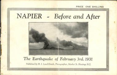
Booklet, Nelson Stedman, Napier Before and After the Earthquake of February 3rd 1931, c1931
The earthquake at Napier, also known as the Hawke's Bay Earthquake, took place on 03 February 1931 at about 10.45 am. There was no warning before the ground started to heave and roll in waves. It was not possible to stand without support, and the violent motion caused stone and brick buildings to collapse into the streets causing death and injury to hundreds who were going about there daily business. Fires started almost immediately, and with the water mains shattered, the fire fighters were powerless to stop or prevent the spread of the flames. Within twelve hours the greater part of the business area of Napier and its port was totally destroyed. As a result of the pressure which caused the upheaval, the levels of the town and the surrounding district have been altered. The town and the harbour were raised from five to seven feet, and many parts of the inner harbour became dry land. Small booklet of 18 pages with photographic comparisons of New Zealand's Napier region before and after the 1931 earthquake.napier, new zealand, earthquake, lovell-smith, stedman, boston, port ahururu, westshore, clive square, hawke's bay -
 Flagstaff Hill Maritime Museum and Village
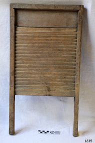
Domestic object - Washboard, Late 19th to early 20th Century as item has wooden riffles common before 1900
A washboard is a tool designed for hand washing clothing. With mechanized cleaning of clothing becoming more common by the end of the 20th century. The traditional washboard is usually constructed with a rectangular wooden frame in which are mounted a series of ridges or corrugations for the clothing to be rubbed upon. For 19th-century washboards, the ridges were often of wood; by the 20th century, ridges of metal were more common. A "fluted" metal washboard was patented in the United States by Stephen Rust in 1833. Zinc washboards were manufactured in the United States from the middle of the 19th century. In the late 20th century and early 21st century, ridges of galvanized steel are most common. Clothes are soaked in hot soapy water in a wash tub or sink, then squeezed and rubbed against the ridged surface of the washboard to force the cleaning fluid through the cloth to carry away dirt. A significant item for cleaning clothes still in use today in many countries giving a snapshot into the domestic life of a housewife.Washboard wooden rectangular with wood grid and 2 legsNoneflagstaff hill, warrnambool, shipwrecked-coast, flagstaff-hill-maritime-museum, shipwreck-coast, flagstaff-hill-maritime-village, clothes washing, cleaning, 19th century washing appliances, scrub board, washboard -
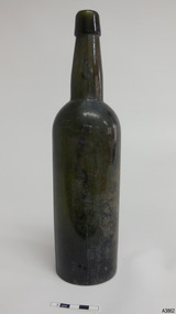 Flagstaff Hill Maritime Museum and Village
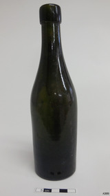
Container - Bottle, Mid-to-late 1800s
This olive green bottle was handmade by a glassblower and is the typical shape of a ‘gallon’ type liquor bottle, which has the capacity of one-sixth of an imperial gallon, about 750ml. It was made around the mid-to-late 1800s. The bottle was recovered from an unnamed shipwreck in the coastal water of Victoria. It is part of the John Chance Collection. Glassblowers made bottles like this one by blowing into a long metal pipe or reed with a blob of molten glass at the end of it. The shape of the glass would be blown out to fit into the shape of the mould. Once it set, the glass was removed from the mould and the glassblower would continue using the pipe to create the neck and another tool to finish the base. The bottle would be cracked off the end of the glassblower’s pipe and a blob of molten glass would be added to the top to form the mouth and lip of the bottle. The seal was usually a cork, often held in place with tape. Although the bottle is not linked to a particular shipwreck, it is recognised as being historically significant as an example of bottles imported for use in Colonial Victoria in the mid-to-late 1800s. The bottle is also significant as it was recovered by John Chance, a diver in Victoria’s coastal water in the late 1960s to early 1970s. Items that come from several wrecks have since been donated to the Flagstaff Hill Maritime Village’s museum collection by his family, illustrating this item’s level of historical value. Bottle, dark olive green glass, tall thin Gallon type. Lip is straight, deep, with thin horizontal lines in glass. Neck has gradual flare, body has side seams, heel has uneven thickness, and base is concave, without pontil mark. No inscriptions. Glass has imperfections. Handmade in mould. Body has score marks and is worn down one side. flagstaff hill, warrnambool, flagstaff hill maritime museum, maritime museum, shipwreck coast, flagstaff hill maritime village, great ocean road, shipwreck artefact, john chance, glass bottle, antique bottle, gallon bottle, handmade, mouth blown, pontil mark, blown bottle, liquor bottle, 19th century bottle, collectable, olive glass, green glass, mould, 1800s bottle -
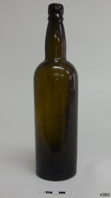 Flagstaff Hill Maritime Museum and Village
Container - Bottle, Mid-to-late 1800s
This olive green bottle was handmade by a glassblower and is the typical shape of a ‘gallon’ type liquor bottle, which has the capacity of one-sixth of an imperial gallon, about 750ml. It was made around the mid-to-late 1800s. The bottle was recovered from an unnamed shipwreck in the coastal water of Victoria. It is part of the John Chance Collection. Glassblowers made bottles like this one by blowing into a long metal pipe or reed with a blob of molten glass at the end of it. The shape of the glass would be blown out to fit into the shape of the mould. Once it set, the glass was removed from the mould and the glassblower would continue using the pipe to create the neck and another tool to finish the base. The bottle would be cracked off the end of the glassblower’s pipe and a blob of molten glass would be added to the top to form the mouth and lip of the bottle. The seal was usually a cork, often held in place with tape. Although the bottle is not linked to a particular shipwreck, it is recognised as being historically significant as an example of bottles imported for use in Colonial Victoria in the mid-to-late 1800s. The bottle is also significant as it was recovered by John Chance, a diver in Victoria’s coastal water in the late 1960s to early 1970s. Items that come from several wrecks have since been donated to the Flagstaff Hill Maritime Village’s museum collection by his family, illustrating this item’s level of historical value. Bottle, dark olive green glass, tall thin Gallon type. Lip is double; rounded upper, flared lower. Neck is slightly bulbous. Body has shoulder seam, then tapers inwards to base. Concave base with small pontil mark. No inscriptions. Handmade in mould. Body has sediment inside, top to bottom. Glass is worn down one side. flagstaff hill, warrnambool, flagstaff hill maritime museum, maritime museum, shipwreck coast, flagstaff hill maritime village, great ocean road, shipwreck artefact, john chance, glass bottle, antique bottle, gallon bottle, handmade, mouth blown, pontil mark, blown bottle, liquor bottle, 19th century bottle, collectable, olive glass, green glass, mould, 1800s bottle, bulbous neck -
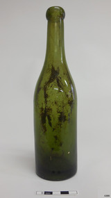 Flagstaff Hill Maritime Museum and Village
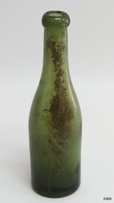
Container - Bottle, c. 1840s - 1870s
This green glass bottle has been handmade from about the 1840s to 1870s. The bottle, possibly used to store or soda or mineral water, was found in the coastal waters of Victoria. It is part of the John Chance Collection. Glassblowers made bottles like this one by blowing air through a long pipe into the molten glass blob at the end of the pipe. The glass was blown out to fit into the shape of the cylindrical dip mould. Once it hardened, the glass was removed from the mould and the glassblower would continue using the pipe to create the neck while carefully using a tool to hold the base. A 'ponty' tool would have been used to form the base. The mouth of the bottle was cut off from the blowpipe and a piece of soft glass would be added to the mouth to then form the blob collar. Bottles like this would usually be sealed with a cork. Although this bottle is not linked to a particular shipwreck, it is recognised as a historically significant example of handmade, 1840s to 1870s beverage bottles imported for use in Colonial Victoria. The bottle is also significant for its association with John Chance, a diver in Victoria’s coastal waters in the late 1960s to early 1970s. Items that come from several shipwrecks have since been donated to the Flagstaff Hill Maritime Village’s museum collection by his family, illustrating this item’s level of historical value.Bottle, green glass. Applied blob lip with bubble and lump in glass. Shoulder seam, body tapers inward towards base. Thick heel, shallow uneven base. Sediment inside on glass.flagstaff hill, warrnambool, flagstaff hill maritime museum, maritime museum, shipwreck coast, flagstaff hill maritime village, great ocean road, shipwreck artefact, john chance, glass bottle, antique bottle, handmade, mouth blown, blown bottle, collectable, bottle, dip mould, soda bottle, beverage bottle, green glass, blob top -
 Flagstaff Hill Maritime Museum and Village
Container - Bottle, c. 1840s - 1870s
This green glass bottle has been handmade from about the 1840s to 1870s. The bottle, possibly used to store or soda or mineral water, was found in the coastal waters of Victoria. It is part of the John Chance Collection. Glassblowers made bottles like this one by blowing air through a long pipe into the molten glass blob at the end of the pipe. The glass was blown out to fit into the shape of the cylindrical dip mould. Once it hardened, the glass was removed from the mould and the glassblower would continue using the pipe to create the neck while carefully using a tool to hold the base. A 'ponty' tool would have been used to form the base. The mouth of the bottle was cut off from the blowpipe and a piece of soft glass would be added to the mouth to then form the blob collar. Bottles like this would usually be sealed with a cork. Although this bottle is not linked to a particular shipwreck, it is recognised as a historically significant example of handmade, 1840s to 1870s beverage bottles imported for use in Colonial Victoria. The bottle is also significant for its association with John Chance, a diver in Victoria’s coastal waters in the late 1960s to early 1970s. Items that come from several shipwrecks have since been donated to the Flagstaff Hill Maritime Village’s museum collection by his family, illustrating this item’s level of historical value.Bottle, green glass. Applied blob lip. Shoulder seam, ripples in body, which tapers inwards towards base. Thick heel, shallow uneven base. Sediment inside bottle. Scratches in glass. flagstaff hill, warrnambool, flagstaff hill maritime museum, maritime museum, shipwreck coast, flagstaff hill maritime village, great ocean road, shipwreck artefact, john chance, glass bottle, antique bottle, handmade, mouth blown, blown bottle, collectable, bottle, dip mould, soda bottle, beverage bottle, green glass, blob top -
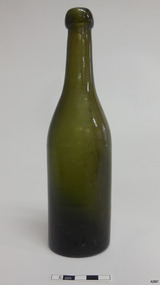
 Flagstaff Hill Maritime Museum and Village
Container - Bottle, c. 1840s - 1870s
This olive green glass bottle has been handmade from about the 1840s to 1870s. The bottle, possibly used to store or soda or mineral water, was found in the coastal waters of Victoria. It is part of the John Chance Collection. Glassblowers made bottles like this one by blowing air through a long pipe into the molten glass blob at the end of the pipe. The glass was blown out to fit into the shape of the cylindrical dip mould. Once it hardened, the glass was removed from the mould and the glassblower would continue using the pipe to create the neck while carefully using a tool to hold the base. A 'ponty' tool would have been used to form the push-up base. The mouth of the bottle was cut off from the blowpipe and a piece of soft glass would be added to the mouth to then form the collar. Bottles like this would usually be sealed with a cork.Although this bottle is not linked to a particular shipwreck, it is recognised as a historically significant example of handmade, 1840s to 1870s beverage bottles imported for use in Colonial Victoria. The bottle is also significant for its association with John Chance, a diver in Victoria’s coastal waters in the late 1960s to early 1970s. Items that come from several shipwrecks have since been donated to the Flagstaff Hill Maritime Village’s museum collection by his family, illustrating this item’s level of historical value.Bottle, olive glass. Applied straight lip with bumps and bubbles. Shoulder seam. Body tapers inwards towards base. Heel has uneven thickness. Concave push--up base. Some imperfections, blow lines and scratches in glass. flagstaff hill, warrnambool, flagstaff hill maritime museum, maritime museum, shipwreck coast, flagstaff hill maritime village, great ocean road, shipwreck artefact, john chance, glass bottle, antique bottle, handmade, mouth blown, blown bottle, collectable, bottle, dip mould, soda bottle, beverage bottle, green glass, olive glass -
 Flagstaff Hill Maritime Museum and Village
Container - Bottle, c. 1840s - 1870s
This green glass bottle has been handmade from about the 1840s to 1870s. The bottle, possibly used to store or soda or mineral water, was found in the coastal waters of Victoria. It is part of the John Chance Collection. Glassblowers made bottles like this one by blowing air through a long pipe into the molten glass blob at the end of the pipe. The glass was blown out to fit into the shape of the cylindrical dip mould. Once it hardened, the glass was removed from the mould and the glassblower would continue using the pipe to create the neck while carefully using a tool to hold the base. A 'ponty' tool would have been used to form the shallow base. The mouth of the bottle was cut off from the blowpipe and a piece of soft glass would be added to the mouth to then form the lip. Bottles like this would usually be sealed with a cork.Although this bottle is not linked to a particular shipwreck, it is recognised as a historically significant example of handmade, 1840s to 1870s beverage bottles imported for use in Colonial Victoria. The bottle is also significant for its association with John Chance, a diver in Victoria’s coastal waters in the late 1960s to early 1970s. Items that come from several shipwrecks have since been donated to the Flagstaff Hill Maritime Village’s museum collection by his family, illustrating this item’s level of historical value.Bottle, green glass. Applied blob lip with glass blister. Shoulder seam, body tapers inwards towards base. Thick heel, shallow base. Blow creases and bubbles in glass. Sediment along inside of bottle.flagstaff hill, warrnambool, flagstaff hill maritime museum, maritime museum, shipwreck coast, flagstaff hill maritime village, great ocean road, shipwreck artefact, john chance, glass bottle, antique bottle, handmade, mouth blown, blown bottle, collectable, bottle, dip mould, soda bottle, beverage bottle, green glass -
 Flagstaff Hill Maritime Museum and Village
Container - Bottle, c. 1840s - 1870s
This green glass bottle has been handmade from about the 1840s to 1870s. The bottle, possibly used to store or soda or mineral water, was found in the coastal waters of Victoria. It is part of the John Chance Collection. Glassblowers made bottles like this one by blowing air through a long pipe into the molten glass blob at the end of the pipe. The glass was blown out to fit into the shape of the cylindrical dip mould. Once it hardened, the glass was removed from the mould and the glassblower would continue using the pipe to create the neck while carefully using a tool to hold the base. A 'ponty' tool would have been used to form the shallow base. The mouth of the bottle was cut off from the blowpipe and a piece of soft glass would be added to the mouth to then form the lip. Bottles like this would usually be sealed with a cork.Although this bottle is not linked to a particular shipwreck, it is recognised as a historically significant example of handmade, 1840s to 1870s beverage bottles imported for use in Colonial Victoria. The bottle is also significant for its association with John Chance, a diver in Victoria’s coastal waters in the late 1960s to early 1970s. Items that come from several shipwrecks have since been donated to the Flagstaff Hill Maritime Village’s museum collection by his family, illustrating this item’s level of historical value.Bottle, green glass. Applied blop lip, deep scratch on neck. Shoulder seam, body tapers inward towards base. Wide heel, shallow base. Glass has ripples, creases, scratches and has a rough surface on the outside on one side. Sediment inside bottle.flagstaff hill, warrnambool, flagstaff hill maritime museum, maritime museum, shipwreck coast, flagstaff hill maritime village, great ocean road, shipwreck artefact, john chance, glass bottle, antique bottle, handmade, mouth blown, blown bottle, collectable, bottle, dip mould, soda bottle, beverage bottle, green glass -
 Tatura Irrigation & Wartime Camps Museum
Photos, Arthur Severino, Garrison at Dhurringile, a garrison member at Dhurringile, 1939-1940
Photos in possession of Arthur Severino, a garrison member at Dhurringile, who also helped maintain the powerplant?. Passed on to his son, William (Bill) on his death, along with a sketch of Dhurringile (cat. C0906). The only information known about the photos is what was written on or beside them & that they were from Arthur's time served as a garrison member at Dhurringile. Arthur also apparently helped to maintain the powerplant whilst at Dhurringile. (Some photos of barracks may have been taken at Puckapunyal instead, where he went immediately after Dhurringile, to enlist in 2nd AIF). 1. Arthur in front of barracks doorway 2. Barracks? building 3. View of camp?? 4. Dhurringile mansion, unknown civilians in entrance (caretakers??) 5. Three people seated, Arthur on left 6. View of fenceline, paddocks, possibly Waranga Basin in background 7. Large water tankSeven photos in possession of Arthur Severino, garrison member at Dhurringile November 1939 - June 1940. 3. "March 1940" 4. "November 1939" 5. "Lance Sergeant Arthur James Severino (on left) V82052, 5th Workshop and Park COY. ; Later VX25922 HQ 21st Aust Infantry Brigade 2nd AIF; Tatura 1939" 6. "March 1940" 7. "March 1940"dhurringile, arthur severino, william severino, dhurringile mansion garrison members, puckapunyal, 2nd aif -
 Geelong Naval and Maritime Museum
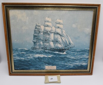
Photograph - Framed Picture, "Lightning", Unsure
Built by the celebrated shipbuilder Donald McKay, the Lightning was the first clipper built in the USA for a British firm. In 1862 on a return trip to Liverpool, it struck an uncharted rock in a rip. No water entered the vessel but on arrival a rock 6 feet long was found sticking through its timbers and beginning to work loose. Under Capt. 'Bully' Forbes, the Lightning made its first voyage to Australia in 77 days, and on its return voyage, made it in a record 64 days. The Lightning's entire life was spent on the Australian run carrying immigrants and cargo. It had the job of carrying free of charge immigrants and early consignments of introduced animals, including rabbits, which were sent to Thomas Austin of Barwon Park, Winchelsea. The wreck of ‘Lightning’ caused by fire was the worst shipping calamity in Geelong's history. Geelong's Centenary celebrations included a re-enactment of the burning of ‘Lightning’.Framed picture of ‘Lightning’ which is a ship particularly historic to the region of Geelong because of its story, the worst shipping calamity in Geelong's history.Framed Picture of ship "Lightning"lightning, geelong, ship wreck -
 Otway Districts Historical Society
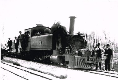
Photograph, Brucker, Beech Forest: Locomotive 5A during construction, c.1902, c.1902
In 1898 a recommendation for a railway of 2 ft 6 in gauge was handed down by the Parliamentary Standing Committee on Railways, to cost $138,000. Construction began in 1900. About 100 men were engaged in laying and ballasting the track while others, not included in the 100, formed the earthworks, culverts and bridges. Locomotive operations initially were two 2-6-2 Tank engines of the narrow gauge A class, dubbed "Coffee Pots", and these were used on the work trains between 1900 and 1902. Because of the lengthy periods of waiting time required to unload sleepers and rails or to load ballast meant that a handy replenishment of coal and water supply was necessary. With earthworks specified to the bare minimum landslips in the narrow cuttings were frequent so a repairer was stationed in each length to deal quickly with minor slips until 1904 when the cuttings were widened.B/W. The driver and seven other men on locomotive 5A and its flat cars at Beech Forest during construction of the line in c.1902. beech forest; railways; loco 5a; -
 Bendigo Historical Society Inc.
Document - History of the Eaglehawk Croquet Club 1909 to 2003
The Eaglehawk Croquet Club was founded in 1909, in premises vacated by the Eaglehawk Bowling Club. There are no records for the years 1910-1942, but the clubhouse was unlined with no electricity or water. During World War II memberships dropped to just 7 members, however between 1943/46 membership increased to 23. Electricity was connected to the Clubhouse in 1947. During the years 1955-58 the club rooms were rebuilt and enlarged. 1959/63 Life Memberships were presented and the club celebrated its 50th birthday with sister clubs and past members. Golf Croquet was introduced in 1975 and was played on Wednesdays (as is still the case today). The club celebrated its 90th birthday with the oldest member at that time - Nell Mitchell- cutting the cake and a stained glass window was also unveiled. We play Association, Golf Croquet and Golf Croquet Pennant and golf croquet membership is increasing.History of the Eaglehawk Croquet Club 1909 to 2003 - 51 pages of printed history. Includes office bearers, referees and officials, and extensive notes.history, bendigo, chinese, eaglehawk croquet club -
 Kew Historical Society Inc
Photograph, Chipperfield's Boat House & Floating Pontoon, 1934
Living with natural processes was frequently a challenge to early European settlers and later residents of what was in the 1850s administered by the Borondara Road Board. This was compounded by the area being bounded on three sides by rivers (Yarra River, Koonung Creek and Gardiner's Creek). In 1849, the historian James Bonwick recorded that "our district [Kew] suffered considerably. Mr Wade speaks of 80 acres, out of 100 acres of his cultivated paddock, covered by water." Newspapers continued to describe major flooding in Kew in 1863, 1869, 1878, 1880, 1889, 1891, 1916 and 1934. While the construction of the Upper Yarra dam in 1957 reduced the levels of flowing downstream, local and riverine floods continue. A number of boat houses operated on both sides of the River Yarra at Kew. Chipperfield's Boat House was located on the Yarra near the corner of Kilby and Willsmere Roads.The Kew Historical Society's pictures and map collections testify to the impact of flooding in the district. They have historical importance in documenting the extent of flooding in the district and its affects on homes, services and recreation. Numerous photographs record flooding throughout the Twentieth Century.Floating pontoon at Chipperfield's Boat House where the canoes were stored, taken in 1934, presumably before the 1934 Flood. This area of the Yarra was shallow with a number of mid river sandbanks and a popular swimming area for locals.yarra river, chipperfield's boathouse, pontoon -
 8th/13th Victorian Mounted Rifles Regimental Collection
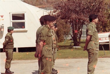
Photograph
The 8th/13th Victorian Mounted Rifles was raised as a regiment of the Royal Australian Armoured Corps on 1 May 1948 with Headquarters in Melbourne and squadrons in Sale, Benalla/Wangaratta and Albury. In 1955 Regimental Headquarters moved to Wangaratta and a second squadron was located at Albury. The Sale squadron transferred to 4th/19th Prince of Wales’s Light Horse. In 1977 8/13 VMR Regiment was reduced to an independent squadron A Squadron 8th/13th Victorian Mounted Rifles and in 1991 was linked with 4th/19th Prince of Wales’s Light Horse forming the VMR Squadron of that regiment.Members of the Women’s Royal Australian Army Corps (WRAAC) were posted to Army Reserve units in the 1980s and 1990s. They were rarely posted to Armoured Fighting Vehicles (AFVs) but were invaluable in the A1 Echelon driving fuel, ammunition, ration and water supply vehicles. Colour photograph of soldiers of ' A ' squadron 8/13 Victorian Mounted Rifles on parade at Buna Barracks Albury 1986. Sergeant D. Reynolds ( WRAAC ) at left; Corporal B. Lewis at right. -
 Wodonga & District Historical Society Inc
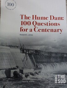
Book - The Hume Dam: 100 Questions for a Centenary, Howard C Jones, 2019
A booklet describing the history of the Hume Dam in question-and-answer format, illustrated by photographs from the Albury City Collection and other sources. This booklet was produced to accompany the exhibition "Turning the sod: building the Hume Dam", on display at Lavington Library from 21 December 2019 -1 March 2020."non-fictionA booklet describing the history of the Hume Dam in question-and-answer format, illustrated by photographs from the Albury City Collection and other sources. This booklet was produced to accompany the exhibition "Turning the sod: building the Hume Dam", on display at Lavington Library from 21 December 2019 -1 March 2020." hume dam, dams -- new south wales, hume dam history, dams -- new south wales -- design and construction -
 Falls Creek Historical Society
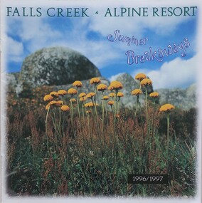
Booklet - Falls Creek Alpine Resort Summer Breakaways 1996/1997
Part of a yearly marketing and information program to promote Falls Creek region for the summer season. . General activities explained in he brochure are:- Enjoying A Bushwalk In The Alpine National Park, Water Sports, Horse Riding, Mountain Bike Riding, Two & Four Wheel Driving, High Country Wining & Dining, Discovering The Wildlife. Daybreaks & Golden Sunsets And Pure Relaxation. The specific activities in the Summer Program of Events include:- Alpine Nature Rambles. Angling Expeditions, Christmas Carols, National Distance Camp, Food, Wine & Wildflower Weekend, High-O Orienteering Event, Mile High Tennis Tournament, High Country Mountain Bike Ride, Classical Music Weekend, Cadbury Red Tulip Giant Easter Egg Hunt And Festivities. The “Breakaways” brochure is a publication of the Falls Creek Chamber of Commerce, an organisation dedicated to establishing Falls Creek as the premier alpine resort In Australia. This item is important as it documents seasonal activities at Falls Creek Alpine ResortA brochure for summer program at Falls Creek for 1996/7. The front cover features an image of yellow wildflowers, mountain rocks and the sky with the title"Falls Creek Alpine Resort Summer Breakawaysfalls creek marketing, falls creek summer programs., falls creek alpine resort, falls creek events and activities -
 Geoffrey Kaye Museum of Anaesthetic History
Container - Ampoule, Propofol, Biochemie Australia (Novartis)
Propofol is an induction agent for anaesthesia and also used in intensive care to induce unconsciousness. Propofol doesn't dissolve in water so it comes in a white, oily solution and must be refrigerated before it’s used. The solution consists of soybean oil, fats purified from egg yolks, and glycerol. Propofol is used as an “induction agent”—the drug that causes loss of consciousness— for general anaesthesia in major surgery. In lower doses it is also used for “conscious sedation” of patients getting procedures on an outpatient basis at ambulatory surgery centres. The main reason propofol is the agent of choice is because it allows for very rapid recovery, is the perfect drug for insertion of laryngeal masks and is the agent of choice for infusions. It has largely replaced thiopentone, the original drug of choice, but this is still available in Australia and used in specific situations. Propofol was linked to the death of Michael Jackson. Large clear glass ampoule with adhered manufacturer's label blue on white label containing the milky liquid of Propofol BC, 20mls.propofol, local anaesthetic, intensive care, jackson, michael, biochemie australia (novartis) -
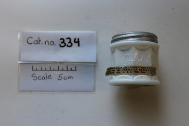 Coal Creek Community Park & Museum
Domestic object - Jar, Nyal's, c.1908
Jar of Nylotis Cold Cream in white opaque glass-type material with metal screw top lid. Paper sticker on base and around one side.On metal lid: Nylotis Improved Cold Cream Marked on the jar: Nylotis Cold Cream On sticker on side of jar: No.584.........Guaranteed Under the Pure Food Act, 1908, by Frederick Stearns & Co., Detroit. Mich., U.S.A...No. 584 N.S.W. Marked on sticker on base: Nyal's Improved Cold Cream 1 1/4 oz.. Directions - Apply freely at night before retiring, after washing the skin with warm water and Nyal's Skin Soap or Pure Castile Soap. Gently massage the skin until the cream is absorbed. for chapped hands, face or lips, sunburn, etc., apply the cream two or three times a day -
 Melton City Libraries
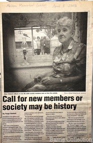
Newspaper, 'Call for new members or society maybe be history, 2003
Mary Tolhurst M&DHS - March 29th Dunvegan Willows Park Melton 1992 Ladies Oral History Day Graham Minns President Ray Radford MC Sound recording transfer to CD 2011 by Tom Wood Edited typescript by Wendy Barrie 2013 I was born in Rockbank, and when I was five years old moved to Toolern Vale and started and finished school there. Toolern Vale only consisted of the Store, Post Office and shop, where you could buy your fodder, and pollard supplies, the Hall, the little Church and the bluestone School. The School changed shape three times from the 1800s[1869] til the time I went there. There was four generations of my family that went there and it was destroyed by fire in 1965. Marjorie nee Myers Butler. Yes, I remember along with it your lovely Ronisch piano. Mary, quite true! Marj what you say about the Ronisch piano. When I came the age to learn music my mum and dad couldn’t really afford it, but still what parents do for their children. They had Marj go along with them and pick this lovely Ronisch piano. It was known round the district. Everyone commented about the loss that lovely piano. After leaving school it was war time, 1939, then it was work, When I was 7 year old I was put out into the cow yard. In 1940 when the soldiers were going away our milk was confiscated it had to go to Bacchus Marsh. It used to go the Sunbury to be brine cooled and then go to Melbourne. Then they took it then to the Lifeguard Milk Factory at Bacchus Marsh. It had to go as condensed milk to the soldiers. This year is 50 years of the Land Army. I was an unofficial Land Army but they still kept check on me. I went onto married life and I followed the cows right through [howls of laughter] and we went on until the 1965 fire. That’s when we got out of the cows. Marjorie asks, was Granny Watts your grandmother or great grandmother? Mary: She was my great grandmother, the midwife of Melton. The 1965 fire started ¾ of a mile above our place, Frank Ryan’s sheds were burnt and his house was saved, then it wiped the School out, the Hall, the Church the Post Office and Store and little house that was Charlie Charlton’s in the early days. Mrs Wilson’s place was saved by the Fire Brigade by pulling boards off the side, and from there it went over the hill and it was stopped at the Rockbank Railway Station. If it had of got over the railway they said it would have gone into Werribee. A lot was burnt out in that strip. Mary nee Nixon Collins: 18 houses burnt that day. Audience question, did Melton get burnt that day? Ray: No. It came down through the Toolern Vale road and cut across about a mile and a half from the cross roads at Toolern Vale from north westerly to the south east and cut through over the Keilor road. Mary: It came in across the creek at Funstons in Toolern, then through Jim Minns. Dorothy was it your place then [nee Knox Beaty] to Ken Beatty’s and from there it went through to Doug McIntosh’s and to Cockbills and the wind changed and it came across to the railway line, and that is where they stopped it. [the cause of the fire was controversial, they had been burning off the night before and there was some talk of someone starting it. It was very hot and very strong wind, it was a terrible day] Ray: When the fire went through McIntosh’s they had a haystack on the north side of their house and the haystack got caught and the fire burnt a hole through the side of the house and the boys pyjamas on the bed. The house was saved. It came through like and express train roaring at you, I was at McIntosh’s when it went roaring past. You couldn’t see, dust and ash and tremendous heat. The fire started about 12 o’clock Jack [husband] said to me, fire, I said where, where? Just up the road, what have I got to do? and he went out and he had gone to the fire and left me. I tried to get the animals and I put out buckets of water, putting the buckets of water out saved my life. Chas Jones and another friend of his came in and they picked up the buckets of water, I thought I had better get out because the fire was on the haystack up the paddock and when I went to go out through the north side of the house and couldn’t get out, I’ll go through the front gate so I went around the other side of the house. I got caught there and Chassy Jones and his friend came round carrying the bucket of water and I panicked. He threw the bucket of water over me. Well that is what saved my life because I was damp, whenever we tried to leave the ball of fire came over me and over my shoulder and my hair was scorched. Chassy Jones lost his truck and Keith Watt his big truck because he had the water tank on it and they couldn’t get out of the yard. Granny Watt’s house, the first private hospital had condemned and Jack and I pulled it down and had it moved up to Toolern and had it in the yard a fortnight and it was all burnt and we didn’t get the shed we wanted. Every 13 years right up until Ash Wednesday fires, there has always been fire close at hand. The 1952 fire went down the back of the house, the 1965 fire took the house, and the house that I live in now, it is the third house that has been on that spot. When the Hunters owned it, Mrs Hunter was nearly burnt in her bed. They had a 13 roomed house. In 1924 the house burnt down, and there was another house was built there and that was the one that burnt down. Edna: So Mary built a brick veneer house. Marjorie: like the three little pigs [laughter] Mary Tolhurst member of the Melton & District Historical Society in the Melton and Moorabool Leader local identities, local special interest groups -
 Eltham District Historical Society Inc
Photograph - Digital Photograph, Alan King, Diamond Creek, Barak Bushlands, Eltham, 2008
A habitat corridor and it strengthens the community. Published: Nillumbik Now and Then / Marguerite Marshall 2008; photographs Alan King with Marguerite Marshall.; p185 Barak Bushlands lie west of the Diamond Creek on the corner of Falkiner Street and busy, noisy Main Road. They form part of an important habitat corridor linking the Yarra River to the Kinglake National Park.1 Manna Gums, tawny frogmouths and platypuses are some of the indigenous plants and animals that have made their home there. The bushlands are the result of more than nine years of hard work by the local community with the Nillumbik Council, to transform a degraded flood plain into this refuge of natural beauty. In 1997, shortly after moving into the new Riverside Estate on Falkiner Street, Eltham, several residents noticed the sorry state of the Diamond Creek and surrounding area. Part of it was used as a cow paddock and although small patches of vegetation survived, the area was infested with weeds, rabbits, rubbish and drainage from the housing estate. At various times the 4.4 hectares had been used as a market garden and for shire stock piles. The residents began to restore the area by revegetating land along the Diamond Creek. In 1998 they established the Friends of the Diamond Creek Falkiner Street Reserve2 and 35 families joined from the 90-house Estate. Carolyn Mellor, as the Friends’ Land Manager, undertook a four-year horticulture course to guide this massive project for a volunteer organisation. Since 1999, she has been the Friends’ President. In 1999 the Friends urged the Nillumbik Council to undertake a feasibility study into establishing a wetland system and urban forest. Work began in 2002 with Nillumbik Council funding the project, supplemented by government grants. The Friends also received grants from Melbourne Water and Parks Victoria. Aided by the Friends and other community members, the Council created the Barak Bushlands consisting of a forest, a wetland, a bridge, a path and open space. The beautiful wetland treats most of the estate’s stormwater runoff. Storm water is filtered through plants in the wetland ponds then is released slowly into the billabong, before flowing into the Diamond Creek. The wetland also helps to minimise flooding and the improved water quality provides a flora and fauna habitat. The Friends and other volunteers planted more than 27,000 plants, more than one third of which they grew from seeds they collected at Lower Eltham and Wingrove Parks. Eltham High School students planted thousands of these through a Year Eight program introduced for this purpose. Other groups who assisted were: Green Corps, local Scouts and Guides – 2nd Montmorency, 1st Diamond Creek and 1st Eltham Cub Packs, Eltham College students, Eltham East Primary School, Landcare members, Eltham Lions Club and the Eltham Baptist Church. To maintain enthusiasm for the mammoth task, the Friends and other volunteers ‘adopted’ trees to water and wrote their names on the stakes. In 2004, to recognise the area’s original occupiers, the reserve was named Barak Bushlands. William Barak, who lived from 1824 to 1903, was the last chief of the Yarra Yarra tribe of the Wurundjeri-willam people. Traces of these original inhabitants remain in scar trees (bark sections removed to make a shield or canoe). That same year the Friends’ group was a finalist in the prestigious Federal Government, Banksia Environmental Awards. The Friends have also participated in Clean Up Australia, removing tonnes of rubbish and regularly testing the billabong, wetland and creek, for pollutants. For years the Friends, together with the Australian Platypus Conservancy, have tagged, measured and checked the health of platypuses from the Diamond and Mullum Mullum Creeks. With Latrobe University the Friends have conducted night walks to view owls, possums, bats and sugar gliders. Challenges for the council and the Friends continue with a large rabbit population, some vandalism, weed eradication and maintenance. However, thanks to this community effort, locals can now escape confined urban living on small blocks of land and enjoy the beauty of indigenous plants and animals. Working together has also strengthened the local community,This collection of almost 130 photos about places and people within the Shire of Nillumbik, an urban and rural municipality in Melbourne's north, contributes to an understanding of the history of the Shire. Published in 2008 immediately prior to the Black Saturday bushfires of February 7, 2009, it documents sites that were impacted, and in some cases destroyed by the fires. It includes photographs taken especially for the publication, creating a unique time capsule representing the Shire in the early 21st century. It remains the most recent comprehenesive publication devoted to the Shire's history connecting local residents to the past. nillumbik now and then (marshall-king) collection, barak bushlands, diamond creek (creek), eltham -
 The Beechworth Burke Museum
Photograph, c1960
The photograph depicts a view across the water at Lake Sambell. The image is thought to date from the 1960s so may show the lake during a period of drought, such as that experienced across South-Eastern Australia in 1967. The present day park and reserve occupies the site of the former Rocky Mountain Mining Company, an open-cut sluice mine that began operations in the mid-Nineteenth Century and operated until the early 1900s, through the peak of Victoria’s Gold Rush. It was converted into a park and leisure area in the 1920s. Lake Sambell was formally opened to the public on Friday 5th October 1928 and was opened by the Victorian Government’s Minister of Lands, Mr Bailey, as part of initiatives to boost the economies and development of country towns. The lake was named after Mr L.H. Sambell, a shire engineer and secretary of the Forward Beechworth Committee who was involved in promoting the transformation of the mining site and promoting plantation forestry and tourism as alternative industries. £300 to begin the process was provided by Mr J. McConvill, a former resident of Beechworth, who is remembered in a street name adjacent to the lake. Residents of Beechworth have worked to raise funds to improve the Lake Sambell reserve several times, such as efforts in the 1930s and 1940s to raise the banks several feet to deepen the water for swimming purposes. Fundraising campaigns include the ‘Ugly Man’ competition conducted on behalf of the Wallace Park-Lake Sambell Development Scheme. The latter competition was run by the Fire Brigade Bend’s team as part of a larger competition called the ‘Mile of Pennies’; it was won by Mr Len Knight of Beechworth’s Commercial Hotel. The ‘Mile of Pennies’ was conducted at a Carnival held on New Year’s Eve, 1947. It was proposed by the Beechworth and District Progress Association. As well as improving swimming facilities, funds were raised to install a caravan park facility near the lake. Funds were also donated by commercial entities, such as £250 received from Zwar Bros. Pty Ltd.The photograph is significant as it shows Lake Sambell at lower water levels, such as may have been experienced during period of drought.Sepia rectangular photograph printed on matte photographic paperObverse: nil Reverse: 3470beechworth, beechworth lake, lake sambell, lake, beechworth and district progress association, forward beechworth committee, ugly man, mile of pennies, wallace park lake sambell development scheme, wallace park-lake sambell development scheme, zwar bros, zwar, l.h. sambell, j. mcconvill, minister of lands, commercial hotel, len knight, rocky mountain mining company, rocky mountain mining co, gold rush, redevelopment, transformation, community fundraising, drought, 1967, 1960s -
 Eltham District Historical Society Inc
Photograph, 35 Ingrams Road, Research, Eltham Heritage Tour, 24 May 1992, 24/05/1992
ELTHAM HERITAGE TOUR The Society excursion on 24th May 1992 was arranged by David Bick, leader of the team carrying out the Shire's heritage study. David selected a number of sites or buildings identified in the study, some of them lesser known components of the Shire's heritage. The tour commenced at the Eltham Shire Office at 10.00 am. Travel was by private car and mini-bus with stops at about twelve locations for commentary by David.It included a short walk in Hurstbridge and lunch at Kinglake. Highlights of the tour included: - 10 am Leave from Shire Offices - 3 Important Trees - A Physical Link to Eltham's First Settlers - Toorak Mansion Gates - A Surviving Farm House - An Intact Circa 1900 Main Street - First Settlers - Gold Miners, and Timber-getters - An Early Hotel - A Pioneering Homestead - Changing Eltham Shire - 20th Century - 4 pm Afternoon Tea and Finish Tour Extract from ELTHAM CULTURAL HERITAGE TOUR (Newsletter No. 85, July 1992, by Bettina Woodburn) "On a right-angle turning of the Eltham Road is Wellers Pub, a Cobb & Co. coaching stop on the way to distant gold-fields and places north of the Yarra River. The Hotel dates from the 1870's. Daily distances for a bullock team was eight miles, horses could do double that distance. We turned into Cassells Road and on the corner of Ingrams Road we admired an elaborate Edwardian villa, 1900 style. The Aqueduct conveying Melbourne's water supply was a communication line and a technological advance in 1891. It has been enlarged and re-faced and no longer used here but piped underground. Proclaimed a linear park it has reverted to crown land, controlled by local Council. Maroondah Dam was constructed in. 1920 to replace the original weir and at that time: the Aqueduct - as established into the landscape - with bridges and tunnels and pine trees were used to stop rubbish polluting the water."Record of the Society's history and activities and highlighting various aspects of the Heritage Study undertaken by David Bick used to create the future heritage overlay for the Shire of Eltham and later Nillumbik Shire.Roll of 35mm colour negative film, 4 stripsKodak Gold 100 5095shire of eltham historical society, activities, heritage tour, ingrams road, research (vic.) -
 Australian Gliding Museum
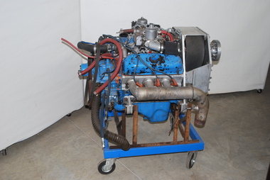
Machine - Auto-Tug Engine, 1983 or prior
The 1982 Ford V6 engine, built at the Ford Essex Engine Plant at Windsor in Ontario Canada, was released by Ford for installation in a number of car and light truck models manufactured in Canada, United States, Mexico and Venezula. Production probably exceeded 7 million items. The Australian Gliding Museum’s exhibit was an engine converted for aircraft use that was bought for the Gliding Federation of Australia “Auto-Tug” program from Javelin Aircraft Company in Wichita in USA. “Auto-Tug” was an experimental program sponsored by the Gliding Federation of Australia to equip a glider – sailplane Piper Pawnee PA-25-150 tug with a water-cooled engine to alleviate the costs of running and maintaining the Lycoming engines fitted to Pawnee tugs in Australia. The program began in 1988 and was aimed at obtaining limited certification for converting dedicated glider – sailplane tow planes. The engine equipped with modified intake manifolds produced 198 hp for flight with the same propeller RPM for take-off as the original Lycoming 0-540 engine. However, fuel consumption was halved as the water cooling of the Ford engine enabled quicker descents with throttle closed following the release of the sailplane. Based on the results of GFA’s program, CASA concluded that engine was quite suitable for an aircraft installation and rated it more reliable than the equivalent Lycoming and Continental aircraft engine. The use of the 1982 Ford V6 engine type for Pawnee tug conversions was discontinued when the General Motors LS1 5.7 litre V8 became available. It is understood that a small number of conversions have been done using the LS1 engine. This brief history is based on information obtained from Mike Burns and David Sharples who were involved in the Auto-Tug program from 1988 to 1992. Technical information relating to the 1982 Ford V6 automotive engine is contained in a paper by D.L. Armstrong and G.F. Stirrat of the Engine Engineering Office at Ford. Indicative of technological experimentation in the sport of glidingFord auto engine mounted on mobile standaustralian gliding, glider, sailplane, auto-tug, pawnee, tug, auto, engine, motor, ford, gliding federation of australia, burns, sharples. -
 Puffing Billy Railway
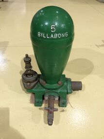
Functional object - Billabong Ram Pump Size #5, Unknown
Pump - Billabong Ram Pump Size #5 Based on available historical data, the Australian-made Billabong Hydraulic Ram is one of the oldest rams produced anywhere in the world The Billabong Hydraulic Ram was first introduced into Australia in 1855 by John Danks and Son Limited, John Danks & Son Pty Ltd began as a plumbing business in 1859, established by brothers John and Samuel. It occupied a prominent site in Bourke Street, Melbourne, for 100 years. The business quickly grew to include factories in Melbourne and Sydney which manufactured and supplied a variety of plumbing and engineering products such as brassware, pumps, windmills and bells. The company was registered in Victoria on 25 January 1889 to continue the hardware manufacturing and supply business founded by brothers John and Samuel Danks in 1859. The head office was based in Bourke Street, Melbourne while another branch was established in Sydney in the 1880s. The company had factories in Melbourne and Sydney. The John Danks and Son Limited catalogue published in 1890, listing Billabong Hydraulic Rams as one of its major machinery products. The catalogue also provides reference to the company’s ram experience and manufacture, beginning by stating that in 1890 they already had 35 years of experience with Billabong Hydraulic Rams. The Hydraulic Ram has stood the test of time and it remains one of the few really practical and efficient uses of natural energy today. It operates without almost any cost, will last indefinitely and, with only two moving parts, is simplicity itself. It requires minimum maintenance and minimum replacement of parts. It is not uncommon to find rams working continuously for many years without any attention. • The Rams do not require electricity, fuel or steam to operate. • They possess simplicity of construction and operation – only 2 moving parts. • Powered only by running water. • Require very minimal or almost no maintenance. • Heavy duty cast Iron base and Dome. This Pump recovered from the Clematis Creek in the Mid 1970's Used to pump water from the creek to the Paradise (Clematis) Hotel. Historic - Farm Equipment - Used to pump water from the creek to the Paradise (Clematis) Hotel.Cast Iron Bronze valveBillabong 5billabong, puffing billy, ram pump -
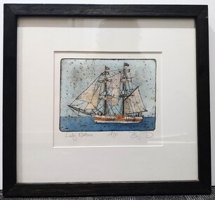 Glenelg Shire Council Cultural Collection
Artwork, other, BRIGIT THOMAS, Lady Nelson, c. 2015
From - theladynelson.org.au T The original Lady Nelson was built at Deptford, in England, in 1799, for service to the Transport Office on the River Thames. She was designed with sliding keels (centre boards), a device invented by Captain John Schank of the Royal Navy to allow surveying in rivers and shallow water ways. On completion she was selected for exploration services in the Colony of New South Wales and sailed for Port Jackson on 18 March 1800 under the command of Lieutenant James Grant. A brig of 60 tons, she carried a crew comprising the commander, two mates and twelve seaman. As she left the River Thames sailors on nearby ships ridiculed her because of her size and shape, calling her, as she sailed past, 'His Majesty's Tinderbox'. At Portsmouth on the 9th February 1800 she was fitted with four brass carriage guns, three to four pounders, in addition to the two guns already on board. Because of the heavy load she was carrying she was very low in the water, having only two feet nine inches freeboard amidships. The ship finally left Portsmouth on 17th March 1800 as part of an East Indian Convoy. From 1800 to 1825 the Lady Nelson operated around the Australian Coast and fulfilled a variety of roles including exploration, surveying, forming settlements, shifting goods and people around the colonies and capturing pirates. She played pivotal roles in the European settlement of Hobart, Northern Tasmania, Melbourne, Newcastle, Port Macquarie and Northern Territory. Those onboard charted much of Bass Strait, Port Philip, Newcastle, Port Macquarie and (with the Investigator) the coasts of northern New South Wales and southern Queensland. She also has links to other locations around the East Coast such as Trial Bay in NSW and the Mt Gambier area of SA. After 25 years of service while trading on the island of Baba the Lady Nelson was overrun by the islanders, the crew was killed and the ship stripped and later burnt and sunk. A replica of the Lady Nelson was built in the 1980s.Image of a tall ship in sail. The ship is flying both the Aboriginal flag and the Australian Flag. It sails on a calm sea. There are figures on the deck - four in total. The image is mounted on cream board and framed in dark timber. Etching, hand coloured,.Front: 'Lady Nelson A/P BT' - hand written, pencil in between etching and mount Back: Artist's business card glued to back of etching, lower left hand corner:ady nelson, femal artists, female artist, women