Showing 2560 items matching " photo notes"
-
 Ringwood and District Historical Society
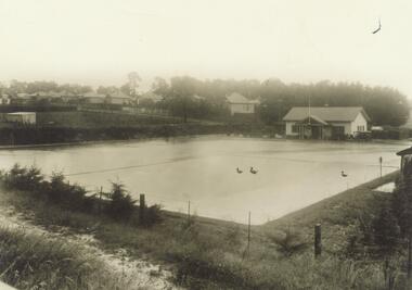
Photograph, First section of bowling club and infant cypress. Houses in Adelaide Street Ringwood. (undated but probably late 1930's)
Photo with ducks superimposed and pencilled note "Ducks on Ringwood Bowling Green"Written on back of photograph, "Shows first section of bowling club and infant cypress. Houses in Adelaide St." -
 Ringwood and District Historical Society
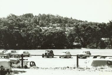
Photograph, Ringwood Oval (now Eastland) looking at Loughnan's Hill with cars in car park (mid-late 1960's)
Notes courtesy Peter Fry: FC Holden = post 1958, Simca Aronde - was around until '60's. Morris 1100 released February 17th 1964 so photo is later that this - probably mid to late 1960'sWritten on back of photograph, "Ringwood Oval (now Eastland) looking at Loughnan's Hill". -
 Orbost & District Historical Society
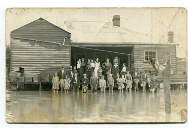
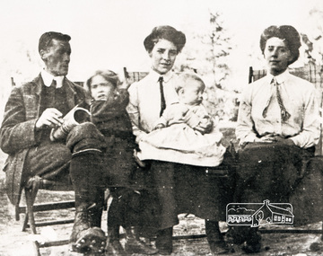
black and white photograph, poss. 1920
In the photograph are the Rice family, Billy Nixon' family and Charlie Johnston. William Nixon, son of James Nixon and Alice (Roberts) Nixon was married to Ilma Muriel (Cadwallader) Nixon on 2 Apr 1902 in Orbost. They had six children - Llewella Adele (Nixon) King, Sydney William Columbo Nixon, Arthur Harry Nixon, Jack Warton Nixon, Claudine Frances (Nixon) Taylor and Daphne Joyce (Nixon) Menz Damage estimated at £500,000 was caused by the 1934 floods in the Orbost district. This 1934 flood was devastating, destroying a section of the 1922 Orbost bridge, wrecking fences, bridges and roads, dumping silt and debris on the rich river flats and drowning cattle. Note: although this card has the date 1934 written onto the rear, the flood incident depicted most likely dates from 1920 (ref. Weekly Times, Saturday 6 March 1920 p 41 when this photo was printed).This item is a pictorial record of a flood in 1920 (ref. Weekly Times, Saturday 6 March 1920 p41). Snowy River flood are a feature of the Orbost area. These floods cover the rich agricultural land. A black / white photograph / postcard of a group of people standing in floodwaters outside a timber building. Included are young children and babies being held by women. Two boys are holding dogs in front of them.on back - "Billy Nixon's house (now Downys 1991)"orbost - floods - nixon - 1920 -
 Ringwood and District Historical Society
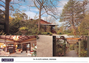
Document, Real Estate History of "Shadowood", 74-76 Alto Avenue, Croydon, Victoria
Folder of Estate Agent's notes compiled in preparation for property auction, 11th October, 2008. Two-page history of "Shadowood", display photo of house with floor plan dating from circa 1920s, copies of LANDATA title documents. Map of Wicklow Hills subdivision, including Alto Avenue, Elesmere Avenue, Glenora Avenue, Wicklow Avenue, and railway line to Lilydale. Title Vol 1323 Fol 264412 Allotment 43C Parish of Warrandyte - Ann McKean, dated 6th October, 1881. Title Vol 1937 Fol 387367 Part of Allotment 43C Parish of Warrandyte - Richard Bonynge Kelly, 11th August, 1887. Title Vol 2728 Fol 543569 Part of Allotment 43C Parish of Warrandyte - Thomas Robertson, 27th July, 1898. Title Vol 4161 Fol 832181 Part of Allotment 43C Parish of Warrandyte - John Gordon Robertson, 4th November, 1918. Title Vol 4490 Fol 897808 Lots 82 and 83, Plan of Subdivision 7478 - Elizabeth Rutherford Morell, 12th August, 1921. Title Vol 4617 Fol 923322 Lot 82, Plan of Subdivision 7478 - Flora Clapperton, 23rd September, 1922. Title Vol 8409 Fol 533, part of Lot 82, Plan of Subdivision 7478 - Hugh Ravenscroft Hastings Wettenhall and Sybella Anne Wettenhall, 1st May, 1962. -
 Orbost & District Historical Society
book, Hepburn, Dorothy, State School Number 3267 Lower Bendoc East Gippsland Victoria, C 2002
Located near the NSW border in the far east of Victoria, the Bendoc school served the needs of a rural population which opened the land to grazing at the turn of the century. It opened on September 8 1896. In December 1956 falling attendances forced the Education Department to close it. It is interesting to note that children here sought their secondary education in NSW. The first head teacher) was John M. Cass and the last R R King. In 1953-54 Lower Bendoc operated part-time with Goongerah. In 1955 it regained full-time status, but in 1956 worked part-time with Tubbut. Author, Dorothy Hepburn, attended Bendoc State School.This is a useful reference tool on the history of Bendoc.A spiral bound book with a plastic sheet front. The cover is white with black print and a b/w photo of a man sitting on a wooden chair outside a log building . Underneath is written "FROM HUMBLE BEGINNINGS TO FINAL CLOSURE".bendoc-state-school -
 Merbein RSL Sub Branch
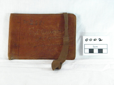
wallet leather, (estimated); World War One
This wallet was donate with a number of other items belonging to Robert James Oscroft.Brown leather wallet thatfolds in the middle,two compartments inside,one for photo,white elastic in fold for notes, brown elastic through slits in the rear of wallet.Inscription on front.Machine sown. inscription on front. "No 2481/Sgt Oscroft R J/12th L'Horse/hard to read/hrd to read/No653world war one, gallipoli, robert james oscroft, 12th light horse, leather wallet, sargent, service number 2481, service number 653 -
 Federation University Historical Collection
Document, Zelda Martin, Central Victorian Goldmining towns - Boom Towns or Ghost Towns?, c1996
Zelda Martin was a PhD candidate at the University of Melbourne.[.1] 4th item in light blue display book titled Research Approach/Overview of Chapters/Confirmation of Canditure/Chapters1,2,3&4 of proposed thesis. *Twenty-seven page article on Victorian goldfields towns titled: Central Victorian Goldmining Towns - Boom Towns or Ghost Towns. The article was written during the author's PhD study. It outlines the context methodology, and resources and the chapters of the proposed thesis: (1) Central Victorian Goldmining Towns - The Context (2) Contemporary Views of the Factors Necessary for Town Growth (3) Outward Manifestations of Town Growth (4) The Trappings of Government (5-9) The Main Towns and Their Hinterland. [.2] 5th item in Light Blue display book as above item. *Chapter 1 of proposed thesis titled 'Pick, Shovel and Tin Dish Mining.' Covers in Section A: Central Victoria - Pre 1851: Aborigines in Central Victoria, Squatters, and Government. Section B: The years 1851-1854: The Early Gold Rushes, Government Reaction, Township Surveys, Legislation, Town Development, Local Government and Early Settlement. [.3] 6th item in Light Blue display book as above item. *2A of proposed thesis titled 'Contemporary Views of the Factors Necessary for Town Growth'. Similar information to Chapter 1 plus extra re towns and maps. Sections: Introduction, Context of Place - Geographical Towns Listed, The Context of Time - Pre1851 Aborigines, Governance of Port Phillip, The Squatters, The Villages of Central Victorian Highlands, Conclusion, Condensed Version of Chapter2B. [.4] 7th item in Light Blue display book as above item. *Chapter2B of proposed thesis. Sections: Area of Research, Schools, Banks, Newspapers, Progress Association, Town Development - Sandhurst (Bendigo), Ballarat, Castlemaine,, Maryborough, Ararat and Stawell. [.5] 8th item in Light Blue display book as above item. *Chapter 3 of proposed thesis titled 'Outward Manifestations of Town Growth'. Sections: Introduction, Contemporary Writing, Educationalists, The Bankers, The Townsfolk, Current Theory, General Theories of Urban Development, and Conclusion. [.6] 9th item in Light Blue display book as above item. *Chapter 4 of proposed thesis titled 'Trappings of Government' Sections: Introduction, Early Government Attitudes to Mining and Town Development, Law and Order, Township Surveys, Legislation, Local Government, Transport and Communication, The People and Lobbyists. [.7] 10th item in Light Blue display book as above item. *'The Rise and Fall of Central Victorian Goldmining Towns'. Includes a map showing main Goldfields, a table showing towns and villages at two points in time - 1857 and 1871; a Bibliography of Primary and Secondary Sources. [.8] Resource No1. Black display book titled Local Towns 1 : Alma: *Brief history *Directory *Maps Amphitheatre / Mountain Hut: *Brief History Post Office Directory Ararat: *Brief History *Post Office Directory 1869 - Alphabetical Listing by Occupation *Ararat - Prominent Citizens of 1858 *Langi-Morgala Museum Avoca: *Brief History *Excerpts from 'Avoca The Early Years', Margery and Betty Beavis; pg1 - Beginnings; pg11 - The Midas Touch; pg25 - Local Gold Escorts; pg27 - A Town is Born; pg51- The Administration of Justice; pg53 - The Ways of the Law; pg61 - News of the Day; pg65 - A Time to Play; pg72 - Land Ownership *Post Office Directory (Bailliere's) 1869 *Tourism Map and Information of area *Historic Avoca - A 5.5km Tour *Avoca & the Pyrenees Region - information pamphlet Ballarat: *Early History of Ballarat - Ballarat Historical Society, Publication No.1: origin of the name; Ballaarat - the Beginning; Fabulous Yields from the Ballaarat Goldfield; *Streetscape Lydiard Street. *Hand drawn map showing Leigh River, Old Portland Bay Road, plaque on road to Colac; etc. *Newspaper article re 'The Theatre Royal' ( which stood in the vicinity of the current Owen Williams store) - 'The News'15/04/1998 *Article - 'Ballarat's Mechanics' Institute Lives On' Ballarat Courier, 14/09/1985 *Article - Standing the Test of Time' The News 17/11/1993 re The Mechanics Institute & picture of the Reading Room *'Ballarat a Study of a City, Phyllis Reichl, pub. Nelson, 1968; no.3 place, time and people field studies series *Investigator Vol.33 No.2, 1998 Geelong Historical Society. Article on pg75 describes Ballarat in 1861 *Folded poster - 'Ballarat 100' a history of telegraph communication, pub. Telecom. Beaufort (Fiery Creek): *Brief history *Post Office Directory [.9] Resource No.2 Black Folder Titled Towns cont.No2 Bendigo (Sandhurst): *'Family & Local History at the Bendigo Library - 1851-2001 150 years of gold'. *Bendigo Government Camp in 1853 illustration; key to sketch and names of Government officers stationed there *Excerpts from 'Bendigo and Vicinity' Adolph Haman *The Bendigo Goldfield Registry - pgs 1-7 Introduction *Excerpt: 'Breaking the Grip' *Excerpt: The Most Go-Ahead Place *Excerpts from 'History of Bendigo' - anti license agitation; laying out of town; proposed railway; gold calls and dividends; the Sandhurst Municipality; journalism *Bibliography Blackwood: *Excerpts from 'Aspects of Early Blackwood - The Goldfield, the Landmarks, the Pioneers' Alan J Buckingham and Margaret F Hitchcock, JG Publishing,1980 Buninyong: *A Brief History *Investigator Vol1 No.2 Feb 1966 Geelong Historical Society. Pg3 - Article re gold escort route - Mt Alexander to Adelaide - (see a simple monument on the Western Highway a few miles out of Horsham. Pg 15 - Ballarat Excursion - re the finding of gold. *Three articles published by Buninyong and District Historical Society Inc: (Magpie Exploration; Finding Gold In The Green Hills; Magpie Exploration; Burnt Bridge to Cargarie to Mt Mercer) *Copies of newspaper articles/items *Buninyong Street Directory Carisbrook: *In the Beginning There Was Carisbrook *The History of the Carisbrook Racecourse Carngham / Snake Valley: *Brief History *Directory Castlemaine: *Directory 1865-1866 - Alphabetical and Street *Poster - Castlemaine A Contemporary Guide "The Great Centre" 1866 - A Contemporary Guide to the Fascinating Past *Pamphlet - Castlemaine District Community Hospital *Map - Castlemaine, Maldon & Surrounding Districts *Map and Information - The Dry Diggings Track - a 55kl walk among historic goldfields relics ( Castlemaine Fryerstown Vaughan Mt Franklin Hepburn Daylesford) *Postcard - Former Court House *Directory 1867 - Alphabetical, Trade [.10] Resource No.3 Grey folder Titled Towns 3 Creswick to Maryborough Creswick: *Brief History *Booklet - "Creswick Cemetery Walk" *Booklet - The Buried Rivers of Gold Heritage Trail Creswick *Creswick Historical Museum Information Sheet *Chronological History of Creswick *Alphabetical Directory of the Borough of Creswick *Creswick's Creek Directory 1856 *Historic Creswick Walking Tour *A Brief Account of the Schools of Creswick - Past and Present *100 Years of Railway Travel in Creswick *The Berry Deep Leads *The Spence Home at Jackass Gully in the Creswick State Forest ( William Guthrie Spence - Pioneer) *The New Australian Mine and the 1882 Disaster *Creswick District News, Issue 7, July August 1999 *The Creswick Miners Walk - Information and Map *Maps Chewton: *Brief History *Directory Clunes: *Brief History *Clunes Street Directory Daylesford: *Brief History *Notable Bushfires in Daylesford District Over More Than a Century - "Black Thursday" 1851; 1862; 1899; the Disastrous Hepburn Fire of 1906; 1939; 1944; 1969. *Post Office Directory -Daylesford and Hepburn Dunolly / Inkerman: *Brief History *Directory *Pamphlet - Goldfields Historical Museum *Pamphlet - Historic Dunolly - Victoria's Best Kept Secret *Map of Gold Workings at Dunolly Area - showing where the main gold rushes occurred *Brief History - Inglewood *Directory - Inglewood - Name Occupation, Dwelling Kingower: *Brief History *Directory - Name / Ocupation / Dwelling Linton / Happy Valley / Piggoreet: *Brief History *Directory - Lintons McIvor: *"A History of the Shire and the Township of Heathcote" by J.O. Randell Majorca: *Brief History *Official Post Office Directory 1869 - Name / Occupation/ Address Maldon (Tarrangower): *Brief History Part 1 *Brief History Part 2 *Post Office Directory *List - Alphabetical Order by Names plus Business and Trade (Tarrangower Times Oct/1858) *List - Alphabetical Order by Trade plus Name and Business *Directory - Name / Occupation / Dwelling Maryborough: *Worsley Cottage - built by Arthur Worsley, a contractor in stonework in 1894 [.11] Resource No. 4 Blue Display Book titled Towns 4 Moliagul to Stawell Moliagul: *Brief History *Moligul Legislative Assembly (Voting?) List - Names and Occupations *Moliagul Victorian Post Office Directory 1868 - Name / Ocupation / Address / Comments *"The Welcome Stranger" gold nugget *The Sunday School *The Welcome Stranger Discovery Walk - information and map Moonambel (Mountain Creek) Redbank *Brief History *List of names extracted from advertisments of the Pioneer and Mountain Creek Advertiser 16/02/1861. *Bailliere's Directory 1869 - Alphabetical List of Name / Occupation / Place St Arnaud: *Brief History Sebastapol: *Brief History *Directory 1869 - Alphabetical by Name; plus occupation and address. Browns and Scarsdale: *Brief History *Browns Street Directory - Name and Occupation Smythesdale: *Brief Description *Smythesdale Street Directory -Name and Occupation Stawell (Pleasant Creek) *Brief History *Victorian Official Post Office Directory - Name /Occupation / Dwelling *Chronology - 1841-1920 *Production of gold statistics - 1879 - 1900 *Big Hill *Extracts from "The Golden Years of Stawell". Chapt 1 - Stawell's Coming Out. Capt. 2 - The Gold Rush. Caapt.3 - Cradle of Democracy. Chapt.4 - The Reefs Becomes Stawell. Chapt. 5 - Rushing In. Chapt.6 - The Pioneers. Chapt 7 - The Decade of Optimism. [.12] Resource No. 5: Blue Display Book titled 'Towns Steiglitz to the The Golden Triangle. Steiglitz: Brief History Victorian Post Office Directory 1869 *Map of Steiglitz *List of maps relevant to Steiglitz history *Information 6 tables of data from "Reports of Mining Surveyors Talbot (Back Creek) Brief History Taradale: Post office Directory 1869 - Name/Occupation/Street. Also list in alphabetical order by Occupation Taradale *Chronological Reference to Taradale Mines *Water - The Coliban System of Waterworks *Joseph Brady *The Syphon Tarnagulla (Sandy Creek) *Brief History *Tarnagulla Businessmen Cameos to give depth to advertisments in 'The Tarnagulla Courier' various issues 1864-1871 *Directory - Name/Occupation /Address *List - Name/Business/Trade Wedderburn (Koorong) *Brief History *List - Name/Occupation The Golden Triangle: *The Early Rushes - Wedderburn / Moliagul / Sandy Creek - Tarnagulla / Jones Creek - Waanyarra / Kingower / Dunolly - Goldsborough / Inglweood *Census of 1857 - Population / Occupations *1858-1871 - A Time of Consolidation- Wedderburn / Moliagul / Sandy Creek- Tarnagulla / Arnold *Census 1871 - Population *Information gleaned from the census data - Demographics / Population / Occupations / marital / Birthplace / Religion / Literacy/ Occupation and Housing Cameos *Graphs - Birthplace of settlers /Male-Female Ratio / Married males / Children under 15 as Percentage of Population / Religion *Census 1857 - Statistical data *Maps *Bibliography [.13] Resource No. 6 - Black Display Book Information and Research in Central Victoria including: *Banking - Research from ANZ Bank Archives *Institutions - also includes articles listed from the Ballarat Times Newspaper *Australian mining History Association - A.M.H.A. Bibliography *Australia's Mining History * Bibliography - Land Surveys Victoria - *1853 Administration (Statistics and Other) includes: schools / ministers of religion / police / military / local administration / licences for sale of spirits / distances between various Victorian gold fields. * Victoria Government Gazette (Copy) - N0. 116, 12/12/1854 includes: Gold Felds Commission of Enquiry & No. 85, 15/09/1854 - Addresses presented to the Lieutenant Governor (Sir Charles Hotham) during his tour through the Gold Fields of Victoria,1854. Addresses on behalf of : the people of Bendigo; Members of the Church of England, Bendigo; Members of the Wesleyan Church on the Bendigo Gold Fields; Bendigo Gold District General Hospital; the Bendigo Prospecting Association; Committee of the Bendigo Local Exhibition; Bendigo District Medical Association; Coloured Americans Resident at Bendigo; German Inhabitants of Bendigo; Landowners, Inhabitants, and Miners of Castlemaine; Inhabitants of Forest Creek; Inhabitants of Heathcote and Gold Miners of McIvor; Residents and landholders of the District of Bacchus Marsh; Inhabitants of Kilmore and Vicinity. *Gold Fields Correspondence 1853: letter from Lieutenant Colonel Valiant, (Officer commanding the Troops in Victoria) to the Lieutenant Governor re threatened disturbance at Sandhurst (Bendigo) regarding the Gold License Fee. * Extracts from a book "Victoria" re Gold Fields Commission of Enquiry involving mainly Ballarat and Castlemaine and a chapter titled 'A Tour to the Victorian Gold-Fields' *Lists of central Victorian newspapers - listed by date published 1851to 1874; by first date available to State Library. *A list of cities and towns showing County, population in 1861 &1871, and municipal status. [.14] Resource no.7. Black display book. *Reference: Papers presented to Parliament Victoria - 1859-1860 4 volumes - relevant sections copied. Contains information on Branches of Government. General / Finance / Gold / Gazette / Commission and Warrant / Statistic. *Gold Fields Act. In accordance with the Act the gold fields are divided into six districts - Ballaarat, Castlemaine , Sandhurst, Avoca, Ararat, and Beechworth.. Official staff in each gold district consists of a Resident Warden, Wardens, Wardens' Clerks, Bailiffs, Chinese Protectors, Chinese Interpreters, and Mining Surveyors. *Gold Receiver *Gaols *Police magistrates and Clerks of Petty Sessions, etc. *Field Branch *Immigration and Emigration Overland - Chinese - 1859 *Population on the Goldfields *The Geological Survey - The Government Geologist is assisited by staff from four branches - the office Branch; the Publishing Branch; the Field Branch and the Museum Branch. *Commission to Enquire Into Sludge dated 10/02/1859 (Some sections copied) - Report to the Honorable Chief Commissioner of Public Works, Melbourne re the mode of carrying the sludge from the puddling mills in Sandhurst without interfering with the drainage of the town and the roads in the neighbourhood. [.15] Resource No.8: Camel display book titled Resource No. 8. Aborigines *Lists of book titles - +"Readings in Victorian prehistory" +"The Aborigines of Port Phillip" +Aboriginal languages and clans" +"A History of the Port Phillip District" +"Langi Ghiran 1: Aboriginal Rock...." +"Koorie History: sources for aboriginal studies in the State Library of Victoria", ed. Tom Griffiths, Melb. Friends of the State Library, 1989 +"The Public Lands of Australia Felix"; settlement and land appraisal in Victoria1834-91 with special reference to the Western Plains", J.M.Powell, Melb. Oxford University Press 1970 +*Bibliography of the Victorian Aborigines' from the earliest manuscripts to 31st December 1970, Massoa, Aldo, Melb. Hawthorn Press, 1971 +"Aborigines in Colonial Victoria, 1836-1886", M.F. Christie, Sydney University Press, 1979 +"Urban and Industrial Australia: readings in Human Geography" ed J.M. Powell, Melb. Sorrett Pub. 1974 *Extracts: -Processes of Pioneer Settlement - The Squatting Occupation of Victoria, 1834-60. J.M. Powell -Areal Variations in the Class Structure of the Central-Place Hierarchy. P. Scott - Volume1 and Volume 2: Notes Relating to the Habits of the Natives of Other Parts of Australia and Tasmania. Compiled from various sources for the Government of Victoria by R Brough Smyth. John Curry, O'Neil, Melb. 1st pub. Melb. 1876. p31-45 - Numbers and Distribution of the Aborigines in Victoria -Victorian Aborigines 1835-1901 - A Resource Guide to the Holdings of the Public Record Office, Victoria; published by the Government Information Centre 1984. *History of the Aboriginal Artefacts Displayed in the Daylesford Museum. F. G. Powell (4 page pamphlet) *Letter to Zelda Martin from Peter Lovett, Cultural Officer, Ballarat & District Aboriginal Co- Operative, 05/02/1997 *Map: Ian Clarke Victorian Tribunal Boundary Map - Clans of Central Victoria. *Victorian Rock Art and Mythology - Article about Mount Langhi Ghiran and myths of the Tjapwarong people. *Two Aboriginal myths relating to the Grampians - 'The Monster Emu' / 'The Aquisition of Fire', by the Aborigines in the Grampians Areas *Article titled (chapter 8) Ballarat - information re camping sites in the region. Lake Wendouree / Lake Burrumbeet (includes a myth) / Mt Bunninyong / Lal Lal / Pitfield / Mount Elephant / Mount Egerton / Meredith / Lake Goldsmith / Lake Learmonth / Ercildoune *Notes on the Aborigines of the Wider Ballarat Region plus European names=Aboriginal names. John Morris 26/07/1995 *Role of Aborigines in Town Development in Central Victoria. Mentions Native Police Force est. in Port Phillip 1842 and Central Board for Aborigines est. 1860 *The Grave of King Billy. (Frank Wilson) Pamphlet. *Camping Places in Central and Northern Victoria. Article re Lake Burrumbeet site. *Programme for the Unveiling of Memorial Cairn for Edward Stone Parker 1802-1865. Note portrait not accurate. Accurate portrait is available in the book "A Successful Failure A Trilogy The Aborigines and Early Settlers", Edgar Morrison, Graffiti Publications, 2002. * Large envelope addressed to Mr G Netherway containing newspaper cuttings regarding the life of Edward Stone Parker, the unveiling of the Memorial Cairn as mentioned above, articles titled 'Episodes from Our Early Days' (Edgar Morrison, Yandoit)- The Black's School, A School At Last and The Final years. Also a typed page titled 'Historical Background to E.S.Parker's Career. Includes an interesting tale titled 'When the cat lay doggo' re laying power leads for the unveiling ceremony at the memorial site. [.16] green display folder titled 'Research Aids' *List of references to Commissioners' & W'ardens' Reports (formerly held at La Trobe Library Archives, now at Public Records Office [PRO]). Indicates town referred to / date of report / name of camp if different to town. * Archive information re Anglican Records *Movement around the Goldfields - Miners and Storekeepers - usefulness of newspapers in providing information - areas covered - Castlemaine, Maldon, Ararat, Stawell, Tarnagulla, Dunolly. *Port Phillip /Victoria Directories 1839/1867 - Chronological list of Directories included in this series. *"Notes on the History of Local Government in Victoria" A.W. Greig Melb. University Press 1925 - Photo-copied extract p5-p40. (Source - Deakin University Library) - Introduction by W.Harrison Moore. Section 1 - Development in New South Wales Before Separation. Section 2 - Development in Victoria After Its Separation from New South Wales. Hand written notations: 'roads, markets, and local government 1855 on' ;'opportunity of squatters in parliament' and 'opportunities of matters in parliament p33' * Notes on the Establishment of Surveyor General's Department 1851and Commissioner of Crown Lands and Survey. * Newspaper articles from The Argus, 1849, re the discovery of gold in the Pyrenees region. * Excerpt - a report on schools - A.B.Orlebar, Inspector; re the need for permanent school buildings rather than tents. *Excerpt from - 'Approaches to Urban History', Sean Glynn: The Case for Caution * Except from - 'The Urban Sprinkle', Weston Bate: Country Towns and Australian Regional History *Reference- 'The History of Land Tenure in the Colony of Victoria', John Quick. References the Haines Land Bill, land tenure and Land Leagues. [.17] Light blue envelope folder titled 'Birtchnell's Ballarat, etc. Directory 1862 *Contains various directories for Smythesdale, Buninyong, Clunes, Brown's and Creswick. [.18] Red envelope folder no.2 titled Victorian Gazetteer *Selected pages from 1869 Victorian Gazetteer on A4 paper (with a handwritten note questioning if some pages are from 1868 Victorian Gazetteer as appears to be different sizes - A3 pages.) Information includes locations and descriptions of towns, hotels, banks, communications and populations. (Does not include names, residences and occupations) [.19] Red Envelope folder titled Bailliere's Official Post Office Directory 1868 (or1869 or a mixture of both?) *Preface *Contains a selection of pages of towns highlighted in yellow in the the index *Work on this directory was commenced in 1867. *Information includes: Municipalities - mayors and councilors; lists of towns naming male inhabitants and their occupations. [.20]Yellow manila folder titled Post Grad Seminar Presentation 1996 *Gives some background to Zelda Martin's proposed thesis and why she chose the topic Gold Mining Towns Boom or Bust [.21] A3 display book - No. 1A * A list of 'Relevant Newspapers collected: The Tarrangower Times and Maldon Advertiser (first published 1858) Includes dates 1858-1867. The Mount Alexander Mail. Includes dates 1854-1866 The Tarnagulla Courier. Includes dates from1864-1871 Dunolly and Burnt Creek Express. Includes dates from 1862-1871 * Selection of newspaper pages from The Mount Alexander Mail 1854 to 1856, mostly showing advertisements for businesses and services provided to that community. [.22] A3 display book - No. 1B * Selection of newspaper pages from The Mount Alexander Mail 1857 to 1866, mostly showing advertisements for businesses and services provided to that community. [.23] A3 display book -No. 2 * Selection of newspaper pages from The Tarnagulla Courier 1864 to 1871, mostly showing advertisements for businesses and services provided to that community. [.24] A3 display book - No. 3 *Selection of newspaper pages from The Tarrangower Times (and Maldon and Newstead) Advertiser 1858 to1867, mostly showing advertisements for businesses and services provided to that community. [.25] A3 display book - No.4 * Selection of newspaper pages from The Dunolly and Burnt Creek Express; and The Dunolly and Betbetshire Express 1862 to 1871, mostly showing advertisements for businesses and services provided for that community. [.26] A3 display book - No.5 Includes: * Bryce Ross's Diggings Directory. Includes instructions for using this directory. This directory was used by "all persons having connexion or desiring to communicate with 'working parties, private friends, or Stores at the Diggings." As a directory for each area wwas completed it was published in each month's issue of Bonwick's "Digger's Magazine." Years c1852/1853. This Directory commences first at the head of Forest Creek. Includes a directory for Bendigo and Ballarat. Of interest at the end of the Bendigo and Ballarat directory is a list of the number of storekeepers, butchers, doctors, smiths, eating houses, lemonade sellers and chapels. * The Castlemaine Directory and Book of General Information Comprehending Glass's Model Calendar for the Two Years 1862 and1863. "zelda martin, victorian goldfield towns, bendigo, castlemaine, ballarat, maldon, stawell, ararat, maryborough, creswick, avoca, heathcote, banks, bank of australasia, union bank of australia, government camp, sandhurst, water supply, tarnagulla, talbot, back creek, mountain creek, police court, carisbrook, dunolly, thompson's foundry, charles clacy, anthony trollope, robert cecil, mount alexander, urbanisation, national schools, education, govenrment, industry, railway, transport, settlement, land settlement in central victoria, steiglitz, joseph brady, the new australian mine, berry deep leads, william guthrie spence, creswick state forest, arthur worsley, worsley cottage, the welcome stranger, moliagul, moonambel, redbank, st arnaud, sebastapol, brown's, scarsdale, clunes, chewton, daylesford, bushfires, inkerman, inglewood, kingower, lintons, happy valley, piggoreet, mcivor, majorca, tarrangower, taradale, the coliban system, the syphon, sandy creek, wedderburn, koorong, arnold, jones creek, waanyarra, the golden triangle, census 1857, blackwood, buninyong, durham lead, magpie, carngham, snake valley, alma, amherst, daisy hill, amphitheatre, mountain hut, beaufort, fiery creek, counties, population, gold fields commission of enquiry1854, william westgarth, gold license fee, lieutenant colonel valiant, administration of the victorian gold fields, commission to enquire into sludge 1859, e.s. parker, edward stone parker, edgar morrison, mount franklin protectorate, dja dja wurrung, memorial cairn, franklinford, mt franklin memorial cairn, jajowurrong, dja dja wurung, tjaowarong, wothowurong, assistant protectors, daylesford museum, buluk, rock art - grampians, aboriginal mythology - grampians, aborigines, first nations people, mount franklin, aboriginal artifacts, lake burrumbeet, native police force, central board of aborigines, yandoit, commissioners' reports, wardens' reports, port phillip/victoria directories 1839-1867, local government - victoria 1853/1854, surveyor general's department - 1850's, victorian schools 1850's, a.b.orlebar, haines land bill, william charles haines, wilson gray, land tenure, land leagues, victorian gazetteer, the tarrangower times and maldon advertiser - 1858-1867, the mount alexander mail 1854-1866, the tarnagulla courier 1864, dunolly and burnt creek express 1862-1871, bryce rose's diggings directory, the castlemaine directory 1862-1863 -
Alexandra Timber Tramway & Museum
Black and white photo, Rubicon tram track
black and white photo of tram tracks in to bush these tracks were layed to harvest timber and build hyrdo power system .note wooden rails .man standing beside tree fern . in good condrubicon tram tracks -
Alexandra Timber Tramway & Museum
Mr Sapsford, rubicon channel and tram tracks
Photograph of local event .Building of Rubicon power house ( station ) Detail of construction evedent in photoUn replaceable .record of local eventsrubicon photo of channel and tram tracks, put in to feed hydro system .note tree harvest and elevated channel to the right taken by mr sapsford of alexandrarubicon channel and tram tracks -
Alexandra Timber Tramway & Museum
Rubicon black and white photo, rubicon Pipeline at Haulage at rubicon
rubicon pipeline at haulage at rubicon .Note tram tracks beside pipeline also men working on pipe with A frame .Mr Sapsford of Alexandra .In good condrubicon Pipline up haulage rubicon -
Alexandra Timber Tramway & Museum
rubicon black and white photo, rubicon power haulage
Rubicon Black and white photo of power house and hualage at rubicon .Note tin hut on outer edge and timber clearing for power lines. Mr Sapsford of AlexandraRubicon Power house and haulage -
 Eltham District Historical Society Inc
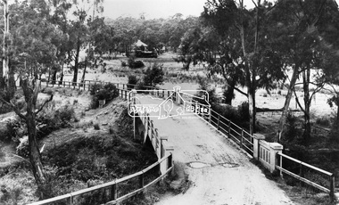
Negative - Photograph, View across bridge at Hurstbridge, Vic, c.1922
View across the new Monash bridge across the Diamond Creek at Hurstbridge looking towards the township, note steam train in centre background of image. Dated between the opening of bridge Nov. 1917 and provision of electric rail service Aug. 1926 - c.1922. Part of a slide show presentation "Bridges & Waterways of the Shire" by Russell Yeoman to the 13 September 1989 Society meeting. The presentation included slides of historic photos from the Shire of Eltham Pioneers collections as well as several recent views.This photo forms part of a collection of photographs gathered by the Shire of Eltham for their centenary project book ,"Pioneers and Painters: 100 years of the Shire of Eltham" by Alan Marshall (1971). The collection of over 500 images is held in partnership between Eltham District Historical Society and Yarra Plenty Regional Library (Eltham Library) and is now formally known as 'The Shire of Eltham Pioneers Photograph Collection.' It is significant in being the first community sourced collection representing the places and people of the Shire's first one hundred years.Digital image 4 x 5 inch B&W Negshire of eltham pioneers photograph collection, hurstbridge, bridge, steam train, diamond creek (creek), railway line, monash bridge -
 Eltham District Historical Society Inc
Negative - Photograph, Osborne family, Warrandyte, c.1909
Negative copy of an original print and associated print copy of Ethel Osborne photos featuring William Alexander Osborne, Audrey Josephine Cahn (nee Osborne), , Ethel Elizabeth Osborne (nee Goodson), Henry Gerard Alexander Osborne and May Goodson (aunt) at Warrandyte Inscribed on reverse of print: WAO Audrey EEO with Gerard May Goodson (aunt) Warrandyte 1908-9 Note: Gerard was born 1909Negative black and white film 120 6x9 format 2 strips Associated B&W printFuji Safety Neopan SSwarrandyte, audrey cahn, audrey osborne, ethel osborne, houses, william osborne, audrey josephine cahn (nee osborne), ethel elizabeth osborne (nee goodson), gerard osborne, henry gerard alexander osborne, may goodson, william alexander osborne -
 Eltham District Historical Society Inc
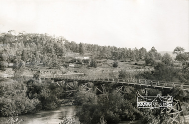
Photograph, Warrandyte Bridge, c.1860, 1860c
Old timber trestle bridge before it was washed away. Note sign in background for P. Bird Timber Merchant Box Hill. Photo has been damp at some stage and image has stuck to glass causing some damage to image in a number of areas.Black and white photograph mounted in thin black framebox hill, p. bird timber merchant, warrandyte bridge, yarra river -
 Eltham District Historical Society Inc
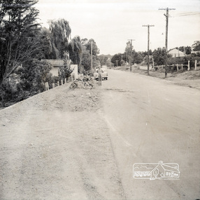
Photograph, Near 145 Mountainview Road, Briar Hill, early to mid 1960s, 1960s
Possibly one of the Watson brothers? Note the red kerosene warning lantern sitting on the bluestone blocks. The EK Holden may have belonged to the Council employee who took the photos. Work is under way at the house one down from the bend where two piles of bluestone are gathered; possibly for terrace edging of the driveway and footpath. These images were from a strip of negatives, most likely taken by a Shire of Eltham employee so the works could have been part of council operations. Many streets in the shire have stonework edges for gardens abutting footpaths where the roads have been cut into the terrain. Much of this stone masonry work was undertaken for the council by C.J. Watson and Sons.Roll of medium format 120 6x6 black and white negative film, 1 stripbriar hill, c.j. watson and sons, mountainview road -
Glen Eira Historical Society
Document - Glen Eira Road, 258, Elsternwick, E.K. Motors
This file contains three items about this porperty, previously numbered 244 Glen Eira Road, Elsternwick: 1/Photocopied photo of Tudor Style garage, c. 1954 taken by Laurie Richards Studio 1954; source unknown Hand written research notes of names of occupiers at number 244 then 258, and neighbours, from Sands and McDougal’s directories Research note dated 09/08/2013 by Claire Barton concerning some of the residents and identifying the change in street numberglen eira road, elsternwick, laurie richards studio, photographic studio, garages, tudor, architectural styles, warburton a.p, shepard geo.r, seward norman h, glover robert e, tudor service station, landvogt j.h, ruddal albt., barrett a.m, goonan and barrett, macey r.h, miller g.t, bennett e and c, evan l.p, petalas t, goracz j, huggins t, doval american dry cleaning, dry cleaners, delicatessens, boot makers, estate agents, dairy products, butchers, service stations -
 Glen Eira Historical Society
Document - Melbourne and Metropolitan Board of Works
This file contains five items relating to Caulfield Council Visits with the Melbourne & Metropolitan Board of Works (MMBW) from 1919 to circa 1974: 1/A photo album containing photos from the MMBW ‘visit to the Headworks, Yan Yean Water Supply, Wallaby and Silvery Creeks’ from 28/02/1919 to 03/03/1919, attended by members of the Caulfield City Council. The album contains 13 original black-and-white photographs, 3 of which are of the council members. The album is accompanied by a report by Felicitie Campbell, written 11/2008, about these visits. 2/A publication from the MMBW documenting its review of operations for 1973-1974. The report contains information about water supply, sewerage and drainage infrastructure completed or in progress during this period including infrastructure in Caulfield, Ormond, Carnegie and Bentleigh. 3/A periodical feature from the MMBW titled ‘Living City’, issue no. 16, Spring/Summer 1974. Included in the article titled ‘Program’ is a notice that construction will continue on the Elster Creek drain from Thomas St. to Wheatley Road, McKinnon. The periodical also includes the names of commissioners W. R. Walters from Caulfield and G. R. Bricker from Moorabbin (back cover). 4/2 maps and 1 information booklet from the Thomson Project Open Day attended by Felicite and John Campbell as representatives of the Caulfield City Council. This was an annual MMBW open date. Date unknown. 5/Resarch notes by Kate Aldred about the photo album and Thomson Project Open Day booklet and their links to Felicite Campbell 01/04./2014.koornang road, draper street, hall street, centre road, brewers road, caulfield intercepting sewer, byron street, caulfield park, elster creek, caulfield, carnegie, ormond, bentleigh, thomas street, brighton east, wheatley road, mckinnon, city of caulfield, bricker g. r., walters w. r., caulfield city council, melbourne and metropolitan board of works, hall councillor, murray councillor, murphy councillor, wharington councillor, phillips councillor, blyth councillor, best robert sir, reid doctor, jowett mr., wooley mr., hindle mr., annual reports, water supply structures and establishments, sewerage and sanitation, sewerage establishments, drainage, town planning, business and finance, councillors, mayors, acqueducts, dams and reservoirs, creeks, waterfalls, rivers, construction sites, north road, north road pumping station, cities and towns, campbell felicitie -
 Glen Eira Historical Society
Document - Bentleigh Baptist Church Vickery Street Bentleigh
Reflections reprinted history extracts from Bentleigh Baptist Church Diary from September 1989 to March 1993. Issues includes a CD with digital photos Reflections reprinted history upon the centenary of Bentleigh Baptist Church 1984 by DL Audemard from May 1985 The Way We Were Feb 1990 pamphlet notes reflections on the churches ministery over the last 50 years by unknown author A brief printed history author unknown and undated on Bentleigh Baptist Church, 10 Vickery Street Bentleigh Two computer generated articles of correspondence between Claire Barton and Robert Bell on the gathering of Bentleigh & Korean Baptist Church history April 2010bentleigh, baptist church, brewer mr, tucker road, box henry, lush gp rev, east boundary, north road, bentleigh baptist church, brighton baptist church, tucker road church, box francis, box edith, clay jack, clay joy, lipman vern, lipman bronwyn, watt family, pioneers, watt richard, watt martha, market gardens, centre road, jasper road, watt herbert, horse drawn vehicles, stamp mr, hall annie, vickery street, watt may, clay family, marriott hector, watt don, watt family, box chris, lipman joy, grewar family, alexander chas, shephard f, chapman samuel rev, chambers h, eunson ta rev, boreham e rev, fletcher w rev, marriott hec – market gardens, kennedy jack, kennedy lil, kennedy isa mary, herron john, seawright celia, streckfuss edith, cole alice, grewar annie, grewar hall, faulkner ern, graham tom, cross mabel, cross w rev, trenches, grewar jean, ormond, wadley mr, wellum mr, hinton wh, rees gp rev, hinton mrs, wade ken rev, wadley mrs, bent st, wade mrs, bell powell, warner lawrence, architects, winckel l rev, richards jl, builders, streckfuss bert, marriott may, streckfuss family, sach florrie, sach family, reid mrs, reid lesley, mcmillan mrs, drapers, mckinnon road, streckfuss edith, simpson mrs, wellum mrs, leadlights, main mary, evans william john, cooke j, cooke mrs, cahill samuel george, smith kate, freeman nancy, wanless mrs, redmore ab, redmore mrs, audemard phil rev, hawkins margaret, ord elton, hawkins shiela, pith ron, bell mr, wallace pat, bell margaret, audemard joan, docker sandra, hubbard mark, thomas bernie, thomas mrs, lamprell mrs, herron mr, herron mrs, freeman mrs, beach mrs, paton john mrs, george lloyd, aspinal eric, bell gwen, sutton mrs, winkel mrs, neil mary, costain mrs, main mrs, baker mrs, cross mrs, kershaw mrs, smith millie, smith jack, freeman alf, harwood lindsay, harwood doreen, bell lesley, bell roberta, bentleigh korean baptist church, barton claire, hoare mike, hoare margaret, bott muriel, bridgeman pat, cook don, small hugh, trewin bill, smith eddie, iggulden sid, neve keith, horsford david, spencer wally, mcewan bill, holmes ron, holmes joyce, pullman peter, pullman elly, probbel peter, robinson john, bott laurie, main alice, disney clarrie, taylor kath, woff miss, rutledge peter, cameo playgroup, bentleigh baptist church, bentleigh, tucker road, foundation stones -
Glen Eira Historical Society
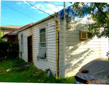
Glen Eira Road, 244, Elsternwick
This file contains two items, Photocopied photo of Tudor Style garage, c. 1954 taken by Laurie Richards Studio 1954, Hand written names of occupiers at number 244 and neighbours from Sands and McDougal’s directories, Research note dated 09/08/2013 by Claire Barton concerning some of the residentsglen eira road, elsternwick, laurie richards studio, photographic studio, garages, tudor, architectural styles, warburton, a.p, shepard, geo.r, seward, norman h, glover, robert e, tudor service station, landvogt, j.h, ruddal, albt., barrett, a.m, goonan and barrett, macey, r.h, miller, g.t, bennett, e and c, evan, l.p, petalas, t, goracz, j, huggins, t, doval american dry cleaning, dry cleaners, delicatessens, boot makers, estate agents, dairy products, butchers, service stations -
 Glen Eira Historical Society
Document - Park Street, 39, Elsternwick
This file contains 3 items about this property: 1/Print of photo of 39 Park Street, Elsternwick from State Library of Victoria website, more likely to be c1880 than c1903 given clothing of woman and 2 children depicted. 2/Print of email with black and white photo of house dated 16/04/2013 included. Handwritten note 'Property demolished 8 July 2013' also has been added. Likely attachments printed of 2 colour photos of same property date marked 16/04/2013. 3/Photocopy of 1913 Sands and McDougall's Directory page 224 showing likely entry for this property.park street, elsternwick, ferguson geo c, attrill edwin, glenwright j, timber houses, verandahs -
Glen Eira Historical Society
Document - Bakeries
This file contains three item about bakeries: 1/Original hand written notes, undated, listing business names/family names with addresses, titled ‘Bakeries in Caulfield’, source unknown. 2/A list of Bakeries - 1913, 1923, 1942 - taken from Sands and McDougall's Directories for suburbs across the City of Glen Eira. 3/Article and photo regarding Aviv Continental Cakes in Glen Hutnly Road, Elsternwick. It covers the history and specialties of the business (the weeklyreview.com.au), date unknown.elsternwick, glenhuntly road, carnegie, gardenvale, gardenvale road, kooyong road, charleston alex f., forrest charles h., frawley’s, charleston’s bakery pty ltd, connors, greeves, anderson, 1xl bakery, cormack bakery, forrest’s bakery, austral bakery, blanchfields bakery, frawley’s bakery, balaclava junction, knight’s bakery, pidgin’s bakery, golden crust, hoskin’s bakery, spooner’s, bakers, aviv continenetal cakes, mihaly family, portman herbert, haldemann hans, portmann lee, portmann kira, portmann felix, bentleigh, caulfield, murrumbeena, caulfield east, pasty houses -
Glen Eira Historical Society
Document - Petrov, Vladimir and Evdokia
Three items concerning Vladimir and Evdokia Petrov, Russian spies who defected to Australia in 1954 and who lived in East Bentleigh as Sven Gustav Allyson and Maria Anna Allyson. Two copies of an article in The Melbourne Weekly Bayside, May 12-18, 2004. Includes a photo of the couple and their East Bentleigh house. A print out from a real estate website showing a photo of the house at 96 Parkmore Road Bentleigh East with handwritten notes Handwritten note regarding Sands and McDougall, Directory of Victoria 1960 which lists S.G. Allyson living at 96 Parkmore Road, Bentleigh Eastbentleigh east, petrov vladimir, petrov evdokia, allyson sven gustav, allyson maria anna, russia, asio, kgb, political parties, parkmore road -
 Glen Eira Historical Society
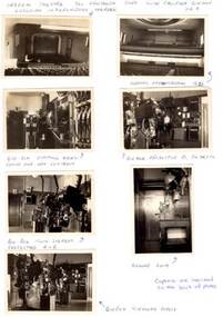
Article - CAMDEN THEATRE
This file contains 3 items relating to the Camden Theatre: 1/7 original black and white photographs of Camden Theatre including photos of the interior and film equipment. Photographer and date unknown. 2/1 report titled ‘Camden Theatre’ by Gerry Kennedy, Ian Hanson and Brian Miller from the Cinema and Theatre Historical Society of Australia Inc. magazine, CinemaRecord, issue 16, May 1997. The report gives a description and a brief history of the theatre and contains a reflective article by former employee, Brian Miller, about his time at the theatre. 3/One file note written by Kate Aldred, 11/04/2014, on the source of the “Camden Theatre’ report.camden theatre, hawthorn road, caulfield south, kennedy gerry, hanson ian, miller brian, cinemas, film and photographic equipment, film projectors, films, cowell ham d.f., yeomans e.c., camden theatre pty ltd, glenhuntly road, art deco, titania cinema, c & w projectors, cinemascope, vista vision, television broadcasting, brunswick ten pin bowling, lawn bowls, bowling club, projectionists, caulfield, glenhuntly fire brigade, classic cinema, elsternwick, trams, carnegie, esquire cinema, renown cinema, hoyts glenhuntly, hanson ian, refreshment rooms -
Glen Eira Historical Society
Medal - QUEEN VICTORIA JUBILEE 1887
This file contains 2 items relating to an 1887 Queen Victoria Jubilee Medal: 1/An 1887 Queen Victoria Jubilee Medal. The medal has an image of Queen Victoria and the words ‘Victoria’s Jubilee 1887’ on one side, and the Australian Coat of Arms with the words ‘Caulfield’s Celebration 21 June 1887’ on the other. The medal is accompanied by a card noting that it is owned by the Glen Eira Historical Society, with no other ownership details mentioned. 2/A print-out from the Museum Victoria website, containing the details of a similar medal owned by Museum Victoria. The print-out includes a photo of the obverse of the medal.festivals and celebrations, medals, caulfield, queen victoria jubilee 1887, queen victoria -
 Glen Eira Historical Society
Article - Caulfield Institute of Technology
Four items about the establishment,history and courses provided at this Institute: 1/Research notes (2 pages in all) regarding the renaming of Caulfield Technical School to Caulfield Institute of Technology in 1968 sourced from La Trobe Library Reference Index. Several dates listed. Reference also to article on construction of building in 'Australian Builder' of January 1950. 2/Photocopy of article from 'The Australian Accountant', April 1975. Gives history of C.I.T. and of Business School courses plus photos. (3 pages) 3/Advertising flyer for 'The David Syme Business School at CIT' listing courses for enrolment by 15/12/1978. 4/Undated black and white photograph of building in progress on site of Caulfield Institute/Monash University Caulfield. Noted on reverse'Chisholm Tower', 'Contact June 29, PIC 3 PG3 100% pl2' ie likely taken by photographer for 'Caulfield Contact'.miller j.o. mr. (b.a. b. com. f.a.s.a.), huggan noel, halstead h.j. mr., kurtz david professor, holmes graham, collins mike, chataway graham, erdonmez hassan, gleeson june, voumard lou, coombe jack, caulfield technical college, caulfield technical school, caulfield institute of technology (cit), k.h. boykett building, monash university, dandenong road, caulfield east, victorian education department, school of business, school of applied sciences, school of engineering, school of industrial studies, school of general studies (humanities sociology art and design), technical schools, technical colleges, education, secondary education, mature age students, david syme business school, 'contact' -
 Federation University Historical Collection
Photograph - Photograph - black and white, Sarah Wright and family, 1928?
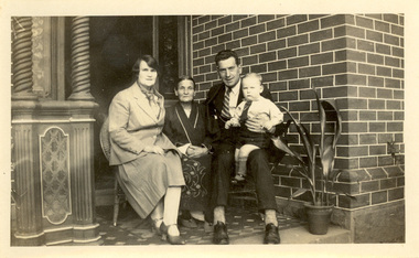
Frank Wright was a renown resident of Smeaton, where he was born. He lived at Laura Villa, and attended Smeaton State School. His father William was a gold miner and his mother's name was Sarah. Their family won many singing and instrumental awards. Frank was tutored by Percy Code and became the Australian Open Cornet Champion by the age of eighteen. A year later, Frank conducted the City of Ballarat Band, and later the Ballarat Soldiers’ Memorial Band. He formed the Frank Wright Frisco Band and Frank Wright and his Coliseum Orchestra. These bands won many South Street awards, and Frank as conductor won many awards in the Australian Band Championship contest. In 1933 Frank Wright sailed to England to conduct the famous St Hilda’s Band and was later appointed Musical Director of the London County Council, where he organized many amazing concerts in parks, in and around the London district. He was made Professor of Brass and Military Band Scoring and conducted at the Guildhall of Music and Drama. Frank was often invited to adjudicate Brass Band Championships around Europe, in Australia, including South Street and in New Zealand. The Frank Wright Medal at the Royal South Street competition is awarded to an individual recognized as making an outstanding contribution to brass music in Australia. As Sarah is in her dressing gown and slippers these photos could refer to a note on an envelope left by Frank which says 'Mother taken on the first day up out of bed - at Lauls on 13th May 1928'. .1) black and white photograph of a man and a woman sitting on a wicker chair which is on a tessellated floor of the front porch of a brick building. The woman is wearing a dressing gown and slippers. The man is Frank Wright and the woman is Sarah Wright, his mother. .2) black and white photograph of a woman sitting on a wicker armchair with a pillow behind her back. The chair is on a tessellated floor on the front porch of a brick building. The woman is Sarah Wright. .3) black and white photograph of a man, two women and a child sitting on a wicker chair which is on a tessellated floor on the front porch of a brick building. The man is Frank Wright and the older woman is his mother Sarah Wright. The younger woman is his sister Laura and her son, Frank Ritchie is sitting on Frank's lap.On the left hand side of the porch are ornate columns and on the right hand side is a potted plant.frank wright, sarah wright, laura wright, tessilated floor, wicker chair, ornate column, child -
 Federation University Historical Collection
Medal - Numismatics, 'Dead Man's Penny' for Edwin Joseph 'Ted' Cannon, c1919
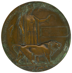
The Dead Man’s Penny is a commemorative medallion which was presented to the next-of-kin of the men and women from England and the Empire who died during World War One. The Dead Man’s Penny was accompanied by a letter from King George V, stating ‘I join with my grateful people in sending you this memorial of a brave life given for others in the Great War’.[http://nma.gov.au/blogs/education/2010/11/14/dead-mans-penny/] Popularly known as the "Dead Man’s Penny", because of the similarity in appearance to the somewhat smaller penny coin. 1,355,000 plaques were issued, which used a total of 450 tonnes of bronze, and continued to be issued into the 1930s to commemorate people who died as a consequence of the war. [http://en.wikipedia.org/wiki/Memorial_Plaque_(medallion)] It was decided that the design of the plaque was to be picked from submissions made in a public competition. Over 800 designs were submitted and the competition was won by the sculptor and medallist Edward Carter Preston with his design called Pyramus, receiving a first place prize of £250.[http://en.wikipedia.org/wiki/Memorial_Plaque_(medallion)] They were initially made at the Memorial Plaque Factory, 54/56 Church Road, Acton, W3, London from 1919. Early plaques did not have a number stamped on them but later ones have a number stamped behind the lion's back leg. [http://en.wikipedia.org/wiki/Memorial_Plaque_(medallion)] Ted Cannon's plaquette does not have a stamped number. Ted Cannon was a gifted artist and cartoonist who studied at the Ballarat School of Mines Technical Art School. During the Battle of Pozieres on the Western Front Ted Cannon worked with the Scout Platoon sketching the enemy's gun emplacements. Ted proved invaluable to the Brigade and brought he came under the attention of the Australian High Command. On 13 September 1916 Ted was given a special assignment for General C.B.B. White. Ted was sent out forward of the Old Mill at Verbrandenmolen (in the Ypres Salient) to draw a panorama of the German lines in the area from Hill 60 to The Bluff. It was a hazardous task and Ted was warned to be careful. Tragically he was sniped by an enemy machine-gunner and sustained severe abdominal wounds. Stretcher-bearers rushed him to the 17th Casualty Clearing Station where he was operated on by the doctors at 8.30 that night. With little chance of success, but ever resilient, Ted remained conscious almost to the end. He died early in the morning of the 14 September 1916. His body was buried in the large Military Cemetery at Lijssenthoek. The effects of the late Ted Cannon were returned to his parents. These were an autograph book, three brushes, prayer book, housewife, whistle, book, hymn book, curios. Another listing gives his effects as "identity disc, letters, photos, wallet, 2 books, Mexican Dollar, 1 cent (Ceylon), 3 German Straps, Fountain Pen, Cigarette-holder, Franc Note, 50 centimes Note, devotional book, mirror, rosary, scapula, metal ring, two combs, book of views, nail clippers, badges, tie clip, Egyptian stamp.[http://recordsearch.naa.gov.au/scripts/Imagine.asp?B=3202589] Ted Cannon was an only child. It is not known how the 'Dead Man's Penny' came into the ownership of the donor, but it is thought that it may have been left in a house owned by the donor's mother. Further information on Ted Cannon can be found at http://bih.ballarat.edu.au/index.php/Edwin_J._Cannon and http://www.ballarat.edu.au/about-ub/history/art-and-historical-collection/ub-honour-roll/c/edwin-joseph-ted-cannon-1895-1916Large bronze medallion or plaquette featuring an image of Lady Britannia surrounded by two dolphins (representing Britain’s sea power) and a lion (representing Britain) standing over a defeated eagle (symbolising Germany). Around the outer edge of the medallion are the words ‘He died for freedom and honour’. Next to Lady Britannia is the deceased solider’s name, with no rank provided to show equality in their sacrifice. (http://nma.gov.au/blogs/education/2010/11/14/dead-mans-penny) The plaque was distributed throughout the British Empire, and the first plaques were distributed in Australia in 1922 "Returned home" by W. & O. Mayne, 2013. ted cannon, edwin joseph cannon, cannon, world war 1, world war -
Federation University Historical Collection
Music Scores, Boosey & Hawkes Ltd, Handwritten sheet music, mid twentieth century
Frank Wright was a renown resident of Smeaton, where he was born on 2 August 1901. He lived at Laura Villa, and attended Smeaton State School. His father William was a gold miner and his mother's name was Sarah. Their family won many singing and instrumental awards. Frank was tutored by Percy Code and was awarded a gold medal for the highest marks in the ALCM examinations in the British Colonies at the age of seventeen years. He became the Australian Open Cornet Champion by the age of eighteen. A year later, Frank conducted the City of Ballarat Band, and later the Ballarat Soldiers’ Memorial Band. He formed the Frank Wright Frisco Band and Frank Wright and his Coliseum Orchestra. These bands won many South Street awards, and Frank as conductor won many awards in the Australian Band Championship contest. In 1933 Frank Wright sailed to England to conduct the famous St Hilda’s Band and was later appointed Musical Director of the London County Council, where he organized many amazing concerts in parks, in and around the London district. He was made Professor of Brass and Military Band Scoring and conducted at the Guildhall of Music and Drama. Frank was often invited to adjudicate Brass Band Championships around Europe, in Australia, including South Street and in New Zealand. The Frank Wright Medal at the Royal South Street competition is awarded to an individual recognized as making an outstanding contribution to brass music in Australia.Handwritten music scores by Frank Wright, some in his hand. 1). 'The Merry Peasant' by Schumann and arranged in parts for brass band by Frank Wright - 3 pages. 2). 'Threshold' by Frank Wright -9 pages. 3). 'Around the Campfire' in parts - 10 pages. 4).'March (Judas Maccabaeus) by Handel and arranged by Frank Wright for the Boys Brigade (a) is written by Frank in pencil, (b) is written in pen with a brown paper cover. 5). 'Anthony & Cleopatra' arranged for the Boys Brigade (a) in written in pencil, (b) is written in pen. 6). 'O Give Me the Hills' written in pencil - 2 pages 7). 'Beneath this Turf' music by Frank Wright and words written in 1842 by Unknown Author - 3 pages. 8). 'If When that Hour Recalling' music by Frank Wright and poem by Thomas Moore, written in pen for 4 brass parts plus violin - 6 pages. 9). 'So Long', Brass Band arrangement by Frank Wright, written in pencil - 2 pages. 10). 'Gluck: March' arrangement by Frank Wright and written in pencil - 2 pages. 11). 'Occasional March' by Handel, arrangement by Frank Wright and written in pen - 5 pages (3 pages of band parts plus a separate Solo Cornet page). 12). 'Bugle Command: Ceremonial March for Bugles and Brass Band' written by Frank Wright - (a) 6 pages of bands parts plus a separate Solo Cornet page written in pen (b) 4 pages written in pencil and pen. 13). 'Scena' & 'Idyll' - Grade 4 Trombone written by Frank Wright in pen - 2 pages. 14). 'Green Corn' Brass Band arrangement by Frank Wright, written in pencil - 1 page. 15). 'Syrian Air' by Geoffrey Allen and arrangement by Frank Wright, with a buff cover (a) written in pencil - 2 pages (b) photo copy of parts - 2 pages (c) single sheet of music written in pencil, blue pen and red pen with some sections crossed out. 16). 'Gavotte: from the Opera "Rodrigo"' by Handel and arrangement by Frank Wright with a brown paper cover (a) 3 pages written in pencil (b) 3 pages written in pen. 17). 'Tales of Hoffman' arranged by Frank Wright for Brass Band 32 page printed booklet in a buff envelope. 18). 'Will Your Anchor Hold' arranged by Frank Wright for The Boy's Brigade - (a) 2 pages written in pencil with a buff cover plus a page with both pen and pencil notes (b) 2 pages written in pen plus a photo copied page for Solo Cornet. 19). Buff folder of 3 pieces of music written in pen - '1. Riverside', '2. Cenotaph' & '3. London Lights' - 7 pages. 20). 'Preludio Marziale (Martial Prelude)' by Frank Wright (a) written in pencil - 2 pages (b) written in pen - 7 pages (c) 7 page printed copy 21). 'Rondo Theme' (a) music written in pencil on the front of a buff envelope (b) 1 page written in pencil 22). Buff folder with two poems set to music by Frank Wright and written in pen - (a) 'My Heart and Lute' by Thomas Moore - 3 pages plus another 3 pages which may be part of this piece (b) 'The Rose' by Thos Croft (bart) - 3 pages. (c) a Musical Pitch Relation Chart for Pipe Organ. 23). 'Purcellian Suite', Purcell arranged by Frank Wright - 3 pages written in pencil and 4 photocopied pages 24). 'G's pl piano study 27/2/52All hand written 8). Written in pencil on front - You can return this score. Keep parts. 9). Notes to musicians written in pen on page 1. 11). Notes to musicians in pencil on page 4. 13). a correction written in red pencil. -
 Federation University Historical Collection
Book - Artwork, Ivy Wilson, Album of original Ballarat Technical Art School folio by Ivy Wilson, c1922
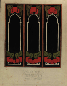
Ivy WILSON (1907-1998) Ballarat | Australia Ivy Wilson was born on 05 July 1907 to Charlotte and Edward Wilson of 167 Mair Street, Ballarat. She attended Humffray Street Primary School and the Ballarat Technical Art School (a division of the Ballarat School of Mines) in 1922. Wilson's student folio contains several stencils hand-cut from paper and card. Among them are stylised graphics of correa, waratah, gum, and kangaroo apple as well as kookaburras, cockatoos and a koala. With diverse applications, stencilling attracted a range of students at the Ballarat Technical Art School. Stencilling was applied to interior surfaces like cushions and curtains. Commercial briefs included wall friezes and murals. One of Wilson's examples, a wreath was subsequently translated into embroidered needlework. Wilson’s folio possibly consists of mostly junior technical work, as she appears to only have sat a single senior Education Department examination, Drawing Plant Forms from Nature. Alternatively, given her focus on textile-based arts, she may have been an evening trade student. Ivy Wilson married Frederick Henry Russell on 23 December 1933 at St Mary's Church of England Caulfield, and had one daughter - Nola, who gifted this folio to the University’s permanent Historical Collection. Ivy died on 17 November 1998 at Caulfield.Silver cloth covered photo album of artworks by Ivy Wilson. Gift of Nola Jones, daughter of Ivy Wilson, 2016 Contains original stencils, plus four photographs of a works kept by Ivy Wilson's family (2016).(Handwritten note) This art is the work of Ivy Wilson. born" 5th July 1907 to Charlotte & Edward Wilson of 17 Mair St. Ballarat. Attended Humffray St. Primary School and Ballarat School of Mines 1922. Married: Frederick Henry Russell December 23rd 1933 at St Marys CofE Caulfield Died 17th November 1998 at Caulfield. Mother of one daughter, Nola. ivy wilson, ballarat tecnical art school, artwork, dana street primary school, alumni, stencilling, stencils, embroidery, textiles, design -
 Federation University Historical Collection
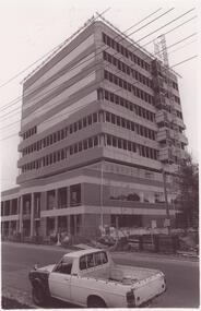
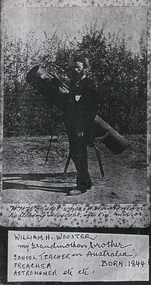
Photograph, William H. Wooster at the Ballarat Observatory, Mount Pleasant
An image of W.H. Wooster with telescope, and a page copy of his handwritten notes outlining his achievements.7707.2 "Notes Grandpa has lectured scores of times in the Sch. of Mines, sometimes for one of the Professors who was ill. Also Lectured in the City Fire Brigade, Ballarat E Fire Brigade, Barkley St Wesn chap., Lydiard St. Wes. Chapl, St Peter's Church of England, Mt Pleasant Wes. Chapl., Baptist Church; & many other places. Preached i the Neil St. Wes. Chapels at Brown Hill, the Gong, Ltl Bendigo, Golden Point, Macarthur St., Mnt Pleasant, the Bible Christian Chppl., and many others. Too photos of most of the places shown in these "Ballarat Views", and many others. And laid the Foundation of the fine Municipal Observatory, in a long series of "Astronomical" and other "Scientific Notes", published in the Ballarat Courier and Ballarat Star, & occasionally in another Newspaper, which roused much public interest in Astronomy. The present official astronomer, Mr John Brittain, is my pupil in Astronomy and Microscopy, and calls me his Father in Science. W.H. Wooster."w.h. wooster, ballarat observatory, microscope, microscopy, churched, preaching, lay preacher, ballarat school of mines, ballarat field naturalists club, observatory, telescope