Showing 4334 items
matching railway road
-
 Ringwood and District Historical Society
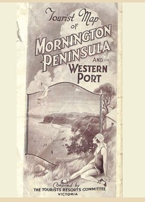
Memorabilia, Tourist Map of Mornington Peninsula and Western Port - 1929
... Multi-fold pictorial map of towns, railways and main roads... of towns, railways and main roads east of Port Phillip Bay from ...Multi-fold pictorial map of towns, railways and main roads east of Port Phillip Bay from Melbourne to Yarra Junction and south to Phillip Island and Wonthaggi, backed by details of main features and points of interest.Photo-Lithographed by Department of Lands and Survey, Melbourne, 2.8.1929. -
 Dandenong/Cranbourne RSL Sub Branch
Map - Burma - Siam Railway
... by T.R.Beaton on the 15th February 2002. He used old railway and road... railway and road maps to show the route and it took him over 15 ...Is of Historical significance. This map was put together by T.R.Beaton on the 15th February 2002. He used old railway and road maps to show the route and it took him over 15 months to put together. T.R. Beaton was Manager/Curator of Australian Government Memorial Museum built above " Hellfire Pass " or Konyu Cutting.Framed picture map of the Burma _ Siam Railway. -
 Eltham District Historical Society Inc
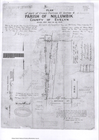
Survey Fleld Notes of Part of Crown Portion 13, Section 4 at Eltham, Parish of Nillumbik, County of Evelyn, 17 May 1926
... Portion of land bounded by: Eltham Railway Station, Main... Arthur Street Eltham Eltham Railway Station Luck Street Main Road ...Portion of land bounded by: Eltham Railway Station, Main Road, Luck Street, Arthur Street Application 4182/215 J.T. Robinson, Licensed Surveyor, 17 May 1926application 4182/215, arthur street, eltham, eltham railway station, luck street, main road, map, survey plan -
 Hume City Civic Collection
Photograph
... of the duplication of the Calder Highway between the Railway crossing... of the duplication of the Calder Highway between the Railway crossing ...The old Calder Highway before the construction of the duplication of the Calder Highway between the Railway crossing and Plumpton Road.A coloured panoramic view of the old Caler Highway at Diggers Rest. It is unmounted.old calder highway, diggers rest, plumpton road, railways, george evans collection -
 City of Kingston
Photograph - Black and white, c. 1957
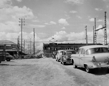
... Black and white photograph depicting the railway crossing... depicting the railway crossing at South Road, Moorabbin ...This image depicts the increasing urbanisation of Moorabbin. While there are several cars in line waiting for the train to go through the crossing and the gates to open, in the distance there is a lot of activity on the road, with many cars.Black and white photograph depicting the railway crossing at South Road, Moorabbin. There is a 'Red Rattler' passenger train going through the level crossing travelling towards the city.Handwritten in blue ink on reverse: 57-4078 Handwritten in red ink on reverse: 82% Handwritten in black ink on reverse: Ch. 6moorabbin, trains, cars, urbanisation, suburbs -
 Ringwood and District Historical Society
Photograph, Main Street Ringwood, looking east c1940
... . Looking East down to Warrandyte Road. Railway Station entrance.... Looking East down to Warrandyte Road. Railway Station entrance ...Black and white photograph (2 copies- 1 large, 1 small)Written on rear of backing sheet: "Main St. Ringwood. Looking East down to Warrandyte Road. Railway Station entrance on right past Carter's - 1940". Clocktower in background in original position. -
 Ringwood and District Historical Society
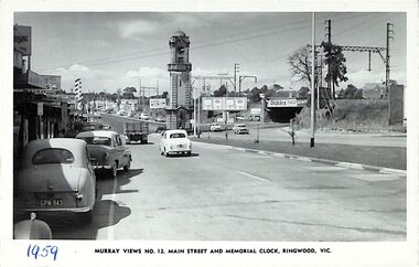
Photograph/Postcard, Postcard - Murray Views No.12. Main Street and Memorial Clock, Ringwood, Vic
... looking east towards Memorial Clock Tower on Warrandyte Road... Road Ringwood North melbourne "1959" handwritten on front ...Black and white "Murray Views" postcard - Maroondah Highway looking east towards Memorial Clock Tower on Warrandyte Road intersection; railway bridge on right. Circa 1959."1959" handwritten on front. -
 Whitehorse Historical Society Inc.
Article, Family Digs In Over Land, 2016
... a narrow strip of land next to the railway tracks in Heatherdale...Whitehorse Historical Society Inc. 2-10 Deep Creek Road ...The level crossing removal Authority intended to use a narrow strip of land next to the railway tracks in Heatherdale Road only to discover that it was privately owned and negotiations are proceeding with the owners.The level crossing removal Authority intended to use a narrow strip of land next to the railway tracks in Heatherdale Road only to discover that it was privately owned and negotiations are proceeding with the owners.The level crossing removal Authority intended to use a narrow strip of land next to the railway tracks in Heatherdale Road only to discover that it was privately owned and negotiations are proceeding with the owners.heatherdale railway station, level crossing removal authority -
 Eltham District Historical Society Inc
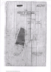
Document - Photocopy, Survey Fleld Notes of Part of Crown Portion 13, Section 4 at Eltham, Parish of Nillumbik, County of Evelyn, 7 May 1925
... Portion of land bounded by: Main Road, Eltham Railway... melbourne Portion of land bounded by: Main Road, Eltham Railway ...Portion of land bounded by: Main Road, Eltham Railway Station Application 46785 J.T. Robinson, Surveyor, 7 May 1925application 46785, arthur street, bible street, eltham, eltham railway station, luck street, main road, map, survey plan -
 Beechworth Honey Archive
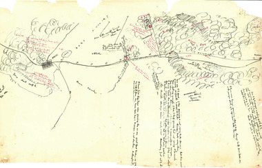
Hand-Drawn Map Centred on Ararat by Frank Lebbell Frost December 1916
... Victoria. Details road and railway and vegetation with comments...-drawn map centred on Ararat, central Victoria. Details road ...This is one of the maps drawn by Frank L. Frost while he was beekeeping in North-East Victoria. This particular map may be reference in the "Wooden" Diary on page 11. Front Side: Hand-drawn map centred on Ararat, central Victoria. Details road and railway and vegetation with comments on flowering. Back Side: Comments in grey lead [ca 1923]hand drawn, hand-drawn, map, ararat, frost, beekeeper, beechworth honey -
 Orbost & District Historical Society
newspaper clippings, February 1971
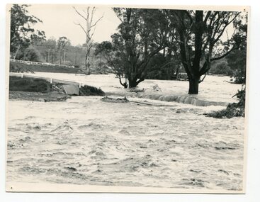
... damage was done to railway infrastructure, roads and farms. More... damage was done to railway infrastructure, roads and farms. More ...These articles were compiled by Mary Gilbert who was the first curator of the Orbost Museum and a prominent historian / teacher in Orbost. The 1971 floods at Orbost were the worst on record. At Jarrahmond the river rose to a height of 11 metres and on the flats spread to one and a half kilometres wide. Considerable damage was done to railway infrastructure, roads and farms. More information from the APRIL, 2008 newsletter by John Phillips. (see orbosthistory.com.au)These articles are contemporary records of a significant historical event in Orbost.A manila folder containing black / white newspaper clippings from various publishers. They all relate to the 1971 floods in Orbost. (Details of contents in catalogue 735-900)floods-orbost-1971 -
 Orbost & District Historical Society
newspapers, February, March 1971
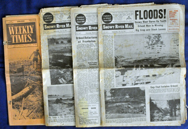
... was done to railway infrastructure, roads and farms. More... was done to railway infrastructure, roads and farms. More ...The 1971 flood was the the worst flood on record. At Jarrahmond it was at least 11 metres and up to one and a half kilometres wide on the flats causing enormous damage to the flood plain. Records say that "The brown floodwater stain in Bass Strait could be seen from passing airliners." Considerable damage was done to railway infrastructure, roads and farms. More information from the APRIL, 2008 newsletter by John Phillips. (see orbosthistory.com.au) These newspapers are contemporary records of a significant local event.Four newspapers relating to the floods in 1971. They contain news articles and photographs of the floods in Orbost in early 1971. 2556.1 is the Weekly Times dated 3.3.1971 and has an orange cover. 2556.2 is a Snowy River Mail dated 17.2.1971. 2556.3 is a Snowy River Mail dated 10.2.1971. 2556.4 is a Snowy River Mail dated 3.3.1971.floods-orbost-1971 snowy-river-mail weekly-times newspapers -
Port Melbourne Historical & Preservation Society
Banner - Port Melbourne Citizens Action Group, Citizens Action Group
... and building of road through Railway Reserve.... of road through Railway Reserve. public action campaigns societies ...Made during the group's campaigns against the loss of railway, the SCDC Bayside development, Council amalgamations and building of road through Railway Reserve.Banner reading 'Port Melbourne Citizens Action Group Fighting for your Rights' '*Market redevelopment * Station Pier *Light rail *Freeway *Your Council' Hand painted onto flannel sheeting in back, purple, red, green and blue; edges hand-boundpublic action campaigns, societies clubs unions and other organisations, town planning - proposals shelved - bayside, ian mckay, citizens action group -
 Whitehorse Historical Society Inc.
Map - Parish Map, Parish of Nunawading, 1892
... . The map includes roads, railway, stations, names of property.... The map includes roads, railway, stations, names of property ...A map copied from 'Directory maps - parishes and counties' dated 26 Nov 1892. Compiled and lithographed by G.S. Bonney. The map includes roads, railway, stations, names of property owners. It has a scale [ca. 1:31,680] 40 chains to an 1 inch.A map copied from 'Directory maps - parishes and counties' dated 26 Nov 1892. Compiled and lithographed by G.S. Bonney. The map includes roads, railway, stations, names of property owners. It has a scale [ca. 1:31,680] 40 chains to an 1 inch.non-fictionA map copied from 'Directory maps - parishes and counties' dated 26 Nov 1892. Compiled and lithographed by G.S. Bonney. The map includes roads, railway, stations, names of property owners. It has a scale [ca. 1:31,680] 40 chains to an 1 inch.maps, parish of nunawading -
 Whitehorse Historical Society Inc.
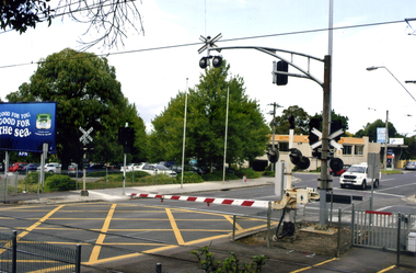
Photograph, Mitcham Railway Crossing, 2012
... Coloured photograph of the railway line over Mitcham Road... Coloured photograph of the railway line over Mitcham Road ...Coloured photograph of the railway line over Mitcham Road as of 2012. The boom gates are down and a white van is coming from the direction of Vermont. In 2013/14 the railway line was reconstructed underground.mitcham railway crossing, railway crossings -
 Eltham District Historical Society Inc
Photograph, Looking west from Main Road from just north of intersection with Diamond Street, Eltham, February 1968, Feb 1968
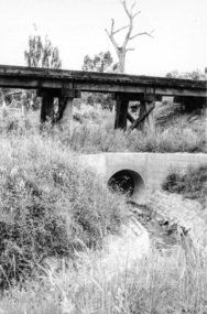
... The watercourse passes under the road and railway... melbourne The watercourse passes under the road and railway ...The watercourse passes under the road and railway at this point. Significant flash flooding occurred along this water course on Christmas Day 2011 causing significant damage to the railway line and road and flooding of Judge Book Village. The drain was swept away including the support pillars of the rail lines timber framework. Judge Book Village had some 40 units flooded before the water entered Diamond Creek. The water had flowed down and flooded Valonia Drive then Grove Street before flowing down the watercourse to Main RoadIn February 1968 an unknown person took a series of photos from the Eltham Hotel at Pitt Street heading north along Main Road through the shopping centre to just north of Elsa Court covering the length of the section of Main Road which was duplicated shortly thereafter. Shows the condition and environment of the streesscape of Main Road, Eltham immediately prior to the duplication between Pitt Street and Elsa Court through the shopping centre. Also shows a number of shops and businesses that operated at that time.Black and white photographduplication, eltham, main road, diamond street, watercourse, drainage, railway line -
 Orbost & District Historical Society
black and white photograph, 11 February 1971
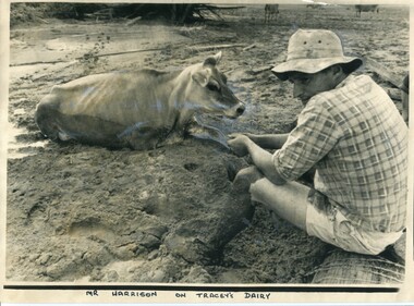
... airliners." Considerable damage was done to railway infrastructure... airliners." Considerable damage was done to railway infrastructure ...This photograph was taken during the 1971 floods at Orbost. The 1971 flood was the the worst flood on record. At Jarrahmond it was at least 11 metres and up to one and a half kilometres wide on the flats causing enormous damage to the flood plain. Records say that "The brown floodwater stain in Bass Strait could be seen from passing airliners." Considerable damage was done to railway infrastructure, roads and farms. More information from the APRIL, 2008 newsletter by John Phillips. (see orbosthistory.com.au)This is a contemporary pictorial record of a significant local event.A large black / white photograph of a man, dressed in shorts and a checked shirt, sitting on a fence post surrounded by mud. He is holding on to the leg of a cow which is stuck in the mud.on front - "Mr Harrison on Tracey's Dairy" on back - " Herald 11 Feb 1971"floods-orbost-1971 tracey-dairy natural-disaster-flood -
 Whitehorse Historical Society Inc.
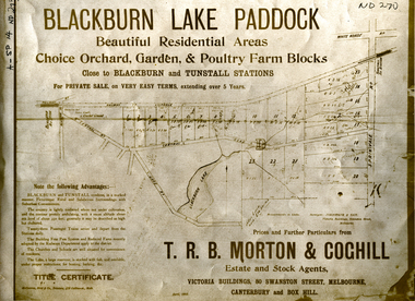
Document, Blackburn Lake Paddock
... by railway to Lilydale, Central Road, Lake Road, Springvale Road...Whitehorse Historical Society Inc. 2-10 Deep Creek Road ...Brochure of Blackburn Lake Paddock consisting of 23 residential areas,Brochure of Blackburn Lake Paddock consisting of 23 residential areas, orchard, garden and poultry farm. Bounded by railway to Lilydale, Central Road, Lake Road, Springvale Road and close to Blackburn and Tunstall Stations.Brochure of Blackburn Lake Paddock consisting of 23 residential areas,t. r. b. morton & coghill, johnstone & tait, mccarron bird & co., blackburn lake paddock, central road, blackburn, lake road, springvale road, nunawading -
 Whitehorse Historical Society Inc.
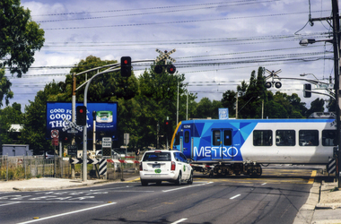
Photograph, Mitcham Railway Crossing
... of traffic using Mitcham Road, the railway line and station were... of traffic using Mitcham Road, the railway line and station were ...Coloured photograph of a Metro train crossing Mitcham Road and heading east towards Ringwood - 2012. In 2013, due to the amount of traffic using Mitcham Road, the railway line and station were reconstructed underground.mitcham railway crossing, trains, railways, transport -
 Orbost & District Historical Society
black and white photograph, February 1971
... airliners." Considerable damage was done to railway infrastructure... airliners." Considerable damage was done to railway infrastructure ...This photograph was taken near the Snowy River Bridge on the the old Princes Highway in Orbost, near the caravan park. The 1971 flood was the the worst flood on record. At Jarrahmond it was at least 11 metres and up to one and a half kilometres wide on the flats causing enormous damage to the flood plain. Records say that "The brown floodwater stain in Bass Strait could be seen from passing airliners." Considerable damage was done to railway infrastructure, roads and farms. More information from the APRIL, 2008 newsletter by John Phillips. (see orbosthistory.com.au)This is pictorial evidence of a significant local event. Floods have been an integral part of Orbost's history for hundreds of years.A black / white photograph of debris, fallen power lines, a tree across the highway and floodwaters across the road.on front at bottom - handwritten in upper case print - " 1971 FLOOD PRINCES HIGHWAY NEAR SNOWY BRIDGE"floods-orbost-1971 -
 Orbost & District Historical Society
black and white photograph, February 1971
... damage was done to railway infrastructure, roads and farms. More...." Considerable damage was done to railway infrastructure, roads and farms ...This photograph is an aerial view of the township of Orbost taken by the Bairnsdale Advertiser newspaper. It was taken from the northern end of the town. The 1971 flood was the the worst flood on record. At Jarrahmond it was at least 11 metres and up to one and a half kilometres wide on the flats causing enormous damage to the flood plain. Records say that "The brown floodwater stain in Bass Strait could be seen from passing airliners." Considerable damage was done to railway infrastructure, roads and farms. More information from the APRIL, 2008 newsletter by John Phillips. (see orbosthistory.com.au)This is a pictorial record of a significant event in the history of Orbost,A black / white aerial photograph of a township with floodwaters in the background.on back - "Note main current through the lagoon 1971."orbost-floods-1971 bairnsdale-advertiser orbost-township -
 Whitehorse Historical Society Inc.
Photograph, Mitcham Railway Station
... estate that runs alongside the railway line to Rooks Road... alongside the railway line to Rooks Road, Nunawading - 2012 Mitcham ...Coloured photograph of a Venture bus pulling into the bus stop on the south side of Mitcham Railway Station.Behind the bus is a building which is the start of a large industrial estate that runs alongside the railway line to Rooks Road, Nunawading - 2012mitcham railway station, transport -
Canterbury History Group
Photograph - Old Toilets in Canterbury, 1/05/1994 12:00:00 AM
... and Riversdale Road, near railway line to Alamein. Part of a set... Prospect Hill Road and Riversdale Road, near railway line ...Toilet in Canterbury lane between Prospect Hill Road and Riversdale Road, near railway line to Alamein. Part of a set of three coloured photographs taken by Hazel Merlo of outhouses (dunnies) in Canterbury with notes on reverse side.canterbury, toilets, lanes -
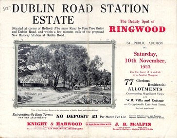 Ringwood and District Historical Society
Pamphlet, Land Sale Brochure, Dublin Road Station Estate - 1923
... images of the area and details of proposed new railway station... and details of proposed new railway station at Dublin Road. Land Sale ..."Extracts from Recent Daily Newspaper - Ringwood Train Service - STATION WANTED AT RINGWOOD EAST. A deputation from the Ringwood East Railway League and Progress Association waited on the chairman of the Railway Commissioners yesterday afternoon and asked that a railway station be erected at Dublin-road, a mile and a quarter from Ringwood. The deputation urged that there were 81 passengers who, if the station were provided, would make daily use of it, and that as the Commissioners had purchased a site for a station at Dublin-road it was evident they had at one time considered it the most suitable site. The Chairman of Commissioners stated that the estimated cost of the station was £3700. Land owners in the locality should pay a proportion of the cost. Members of the deputation replied that there would be no difficulty in raising the money."Multi-fold brochure advertising public auction of residential allotments on Saturday, 10th November, 1923. Brochure includes subdivision features, local facilities and photographic images of the area and details of proposed new railway station at Dublin Road.Subdivision plan includes Dublin Road, Alexandra Road, Vonadawn Avenue, Green Street, Howard Avenue, Wood Street, and Bedford Road (Main Ferntree Gully Road). Auctioneer - Knight & Harwood, 315 Collins Street, Melbourne, Phones Central 10615, 10616. Agent - J.B. McAlpin, Opposite Railway Station, Ringwood, Phone Ringwood 7. -
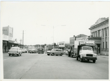 Ringwood and District Historical Society
Photograph, Maroondah Highway outside Town Hall
... Street scene looking west between Railway Station... Railway Station and Wantirna Road, including ANZ Bank, Coles ...Street scene looking west between Railway Station and Wantirna Road, including ANZ Bank, Coles Stores, State Bank, Midway Arcade, Jack Wilson - Removalist, Ringwood S.E.C., Ringwood Lamb Centre, c.1965 -
Whitehorse Historical Society Inc.
Map, The Mascot Estate, Blackburn, 1924
... Advertisement for auction of land between the railway line... for auction of land between the railway line and Whitehorse Road ...Advertisement for auction of land between the railway line and Whitehorse Road in Blackburn.Advertisement for auction of land between the railway line and Whitehorse Road in Blackburn. Includes photos of houses in the neighbourhood. Auction by H. Pallyn & Co and Frank Fisher in conjunction. Street names have changed to Ceylon Street and Terracotta Drive.Advertisement for auction of land between the railway line and Whitehorse Road in Blackburn. land subdivision, whitehorse road, blackburn, simla street, mitcham, king street, blackburn, iona street, blackburn, ceylon street, blackburn, terracotta drive, blackburn, mascot estate, blackburn -
 Orbost & District Historical Society
black and white photograph, February, 1971
... ." Considerable damage was done to railway infrastructure, roads and farms...." Considerable damage was done to railway infrastructure, roads and farms ...This photograph shows the floodwaters during the 1971 flood at Orbost. The two mahogany trees in the photograph stopped the Snowy River from changing its course. The 1971 flood was the the worst flood on record. At Jarrahmond it was at least 11 metres and up to one and a half kilometres wide on the flats causing enormous damage to the flood plain. Records say that "The brown floodwater stain in Bass Strait could be seen from passing airliners." Considerable damage was done to railway infrastructure, roads and farms. More information from the APRIL, 2008 newsletter by John Phillips. (see orbosthistory.com.au)This is a pictorial record of a significant event in the history of floods in Orbost.A black / white photograph of raging floodwaters at the bottom of the Orbost township.orbost-flood-1971 -
 Orbost & District Historical Society
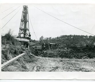
black and white photographs, 15th February 1971
... was done to railway infrastructure, roads and farms. More... was done to railway infrastructure, roads and farms. More ...The 1971 flood was the the worst flood on record. At Jarrahmond it was at least 11 metres and up to one and a half kilometres wide on the flats causing enormous damage to the flood plain. Records say that "The brown floodwater stain in Bass Strait could be seen from passing airliners." Considerable damage was done to railway infrastructure, roads and farms. More information from the APRIL, 2008 newsletter by John Phillips. (see orbosthistory.com.au) The railway line was destroyed and was not expected to be opened for a fortnight. Orbost was cut off by 50 square miles of Snowy River floodwater. These photographs are pictorial records of the 1971 floods which was a significant event in the history of Orbost. They are also associated with the East Gippsland Railway.Three black / white photographs of flood debris and flood waters near a railway line. 3102.l has a pile driver 3102.2 shows a gap in the viaduct and 3102.3 shows men with a tractor cleaning up the debris,3102.1 - on back - "1971 FLOOD REPAIRS TO ORBOST RAILWAY VIADUCT - 15th February 1971. Donated by Audrey Van Den Berg VRH 3693" 3102.2 - on back - " DAMAGE TO RAILWAY VIADUCT ACCUMULATED DEBRIS" 3102.3 - on back - "DAMAGE TO RAILWAY VIADUCT AT ORBOST. CLEAN UP BEGINS"orbost-flood-1971 orbost-viaduct-flood-damage orbost-railway -
Bendigo Historical Society Inc.
Map - HEATHCOTE : COUNTY OF BENDIGO, 11-4-35
... and Bendigo Railway, C.R.B. Main Road. By authority H.J. Green, Govt..., Argyle Station Ground, Wallan and Bendigo Railway, C.R.B. Main ...Map. Heathcote, County of Bendigo, County of Dalhousie,Township of Heathcote, McIvor Creek, Argyle Station Ground, Wallan and Bendigo Railway, C.R.B. Main Road. By authority H.J. Green, Govt. Printer. Photo-Lithographed at the Department of Lands and Survey, Melbourne. 11-4-35. Price 2/-. (number 88 in map cupboard 1)H.J. Green, Govt.Printermap, bendigo, heathcote -
 Wodonga & District Historical Society Inc
Photograph - Fred Rochow Railways Collection - Railway Bridge over the Hume Weir at Sandy Creek
... of the Hume Weir. Due to the higher water line railway lines and roads... to the higher water line railway lines and roads had to be relocated ...The Fred Rochow Railways Collection incorporates photos related to the operation of the Wodonga Railway Station including different types of trains and railways staff C. 1930 – 1990. It was donated to the Wodonga Historical Society by Fred Rochow, a railwayman who spent many years based in Wodonga. He joined the Victorian Railways on 17th June l947 and retired in 1988. For some time, he was a member of the Australian Federated Union of Locomotive Enginemen and served a term as a member of the Trades Hall Council. He had an extensive knowledge of the struggles that took place to achieve better conditions for railway workers. Fred worked for many years as a fireman and then worked his way up the ranks to driver, experiencing many changes from the days of steam locomotives through to diesel trains, locomotives and even the modern XPT train. He worked throughout Victoria at different stages of his career, with his final working years focused on the northeast of Victoria and the Albury to Melbourne line. After his retirement, Fred continued to share his love of steam miniature trains with the community. This collection has local and statewide significance as it captures images of trains, locomotives and personnel who operated the railway services in Wodonga and throughout Northeast Victoria. The railways played a critical role in opening up Victoria and connecting Australia for trade, business, social communication and transport.The bridge at Sandy Creek, near Tallangatta in Victoria. The construction of the bridge was necessitated by the extension of the Hume Weir. Due to the higher water line railway lines and roads had to be relocated. The bridge was built on 45 sets of concrete pillars, each set 42 feet apart. The line to Tallangatta was closed in 1981 and the bridge deck was removed in 1987.railways wodonga, fred rochow, high country rail trail, sandy creek bridge