Showing 2132 items
matching view st.
-
 Ringwood and District Historical Society
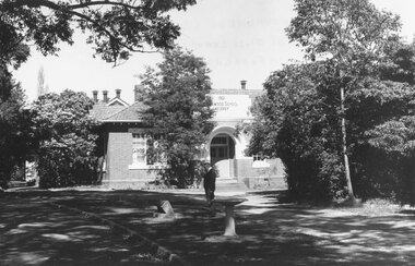
Photograph, Foundation stone for Ringwood State School No. 2997, laid by Mrs. J.K. Turnbull on 15th August, 1889
Photograph of Foundation stone for Ringwood State School No. 2997 was laid by Mrs. J.K. Turnbull on 15th August, 1889, marking the opening of the school situated in Whitehorse Road at the corner of Ringwood Street (1889-1922). Mrs. Turnbull was the wife of the Ringwood Station Master. The stone was removed after the school closed in 1922 and re-laid in 1962 by the School Committee at this subsequent Greenwood Avenue school site and is pictured here being viewed near the entrance in 1973 by Mr. Ron Pullin, Archivist, Ringwood Historical Research Group".Sign below photograph reads, "Foundation stone of Ringwood State School (late Ringwood St.). Now in grounds of Greenwood Avenue Ringwood State School". Inscription on stone, "This foundation stone was laid by Mrs. J.K. Turnbull on 15th August 1889". Printed on plaque below stone, "No.2997 - Ringwood State School 1889-1922. Situated in Ringwood Street, East Side sixty yards north of Maroondah Highway. Foundation stone removed 19?? re-erected by the School Committee 1962". -
 Ringwood and District Historical Society
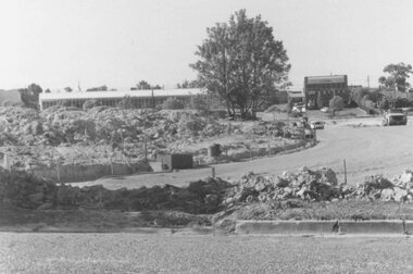
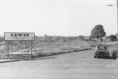
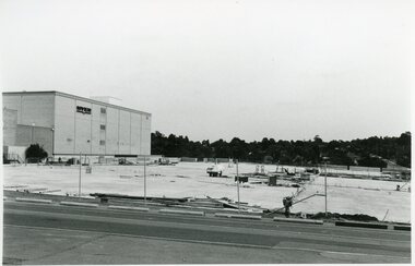
Photograph, Road and carpark construction works for Ringwood Market and Target Square shopping centres, viewed towards Charter and Seymour Streets from Bond Street, Ringwood - 1984
Written on back of photograph, "New roads after demolition of houses, Chartres and Seymour St. for Target Square and market". -
 Ringwood and District Historical Society
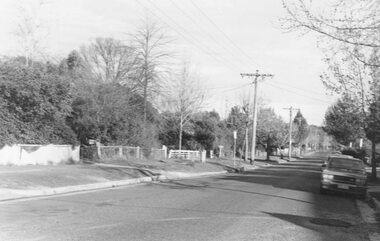
Photograph, Westward view from No.1 Bond Street, Ringwood - 1981
Written on back of photograph, "1981, Bond St. looking west from number one". -
 Ringwood and District Historical Society
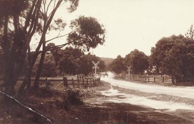
Photograph, Bedford Rd. railway crossing. Ringwood c1920 (2 views)
See also Record 2314 - same scene in 1974 (SS082)Typed below photograph, "Bedford Rd. railway crossing. Great Ryrie St. comes in from right c1920". (2 views) -
 Ringwood and District Historical Society
Photograph, Premises and Shops off Adelaide St, Ringwood etc (4 views). 1958
... Adelaide St, Ringwood etc (4 views). 1958 Written next ...Written next to photographs (Mounted on single sheet): SS0188a: "Looking at the rear of premises in Whitehorse Road from Warrandyte Road to Adelaide Street. SS0188b: "Taken from roof of plumbers shop in Adelaide Street, (Syd Hunt's) June, 1958." SS0188c: "From same vantage point" (as previous photograph" SS0188d: "Car is parked on site of old Bakehouse which was burnt down 1957. Door of oven was dated 1882." -
 Ringwood and District Historical Society
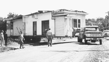
Photograph, Moving sections of house in Adelaide St. Ringwood 1966 (3 views)
... of house in Adelaide St. Ringwood 1966 (3 views) Written on back ...Written on back of photograph, "Moving sections of house in Adelaide St. 1966." "Transporting house from Adelaide St.", and "Moving sections of house in Adelaide St. on site of supermarket". 3 views -
 Ringwood and District Historical Society
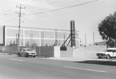
Photograph, Building Construction: 27-29 Ringwood St, Ringwood. 1982 (2 views)
... : 27-29 Ringwood St, Ringwood. 1982 (2 views) Written on back ...Written on back of photograph SS0245a: , "Framing the columns under the first floor of 27-29 Ringwood Street. Social Security buildings in background. Shows Waltons 'Blimp' in sky right of power pole. It was tethered over their store on highway. 25/3/82". On back of SS0245b: "Preparing the foundations of 27-29 Ringwood St. 25/3/82" -
 Ringwood and District Historical Society
Photograph, View from Clock Tower to Adelaide St, Ringwood. 1960
Written on back of photograph, "From clock tower to Adelaide St. "Mail" office with entrance to "Pines" Private Hospital on right. 1960". -
 Ringwood and District Historical Society
Photograph, Corner New and Seymour Streets, Ringwood (4 views). 1981/2
Written on back of photographs, 2/81. Corner New and Seymour Streets."(4 photos) Written on back of photograph SS0356j: "8.1.82. Bond St. entrance to work across Seymour and Charters Streets to highway." -
 Ringwood and District Historical Society
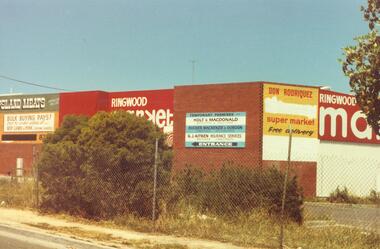
Photograph, Seymour St. Ringwood, 1982. Ringwood Market / Target Square (3 views)
Catalogue card reads, "Seymour St. Ringwood, 1982. ... Ringwood Market." 3 Views. -
 Ringwood and District Historical Society
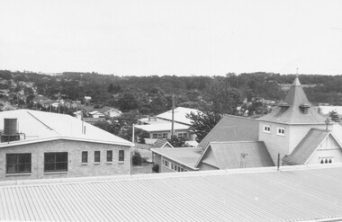
Photograph, St. Paul's Church of England, Ringwood Street, Ringwood, viewed from Town Hall in 1962, 1962
St. Paul's Church of England from Town Hall in 1962Written on back of photographs, "Town Hall roof 12/62. St. Paul's C. of E." -
 Ringwood and District Historical Society
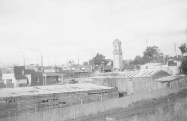
Photograph, View of buildings on Maroondah Highway Ringwood, taken overlooking railway yard from Station St. and Greenwood Ave., 1914
Black and white photograph of buildings in background with post and rail fence in foreground. (2 copies)Typed below photograph, "View of buildings on Maroondah Highway taken overlooking railway yard from Station St. and Greenwood Ave. 1914". Written on backing sheet, "View of township taken from near the Methodist Church showing railway yards, Ringwood Hall and Methodist Church Hall. Methodist Church closed 1915. Photo taken from new one (Cnr. Greenwood St.)". -
 Ringwood and District Historical Society
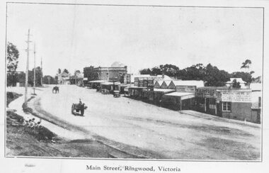
Photograph/Postcard, Main Street, Ringwood, c1924
Black and white photograph of street scene of roadway with shops and horse-drawn vehicles. (3 enlargements, 1 small photograph and 1 postcard of same photograph with various inscriptions).Typed below photo on postcard "Main Street. Ringwood, Victoria. Valentines Series M.4800" Typed below other small photo, "Main Street, Ringwood, Victoria" Typed on back of this photo, "Coped from a circular for Mountain View Estate, J. Press, vendor, Second Av. Kew. In Mullum Rd, 90 yds from Oban Rd. Press, Rangeview & Mountview Avenues. Winnington just completed. 1924." Typed below one of the enlargements, "Main St. Looking west from Warrandyte Rd. c 1924." Also Black and white photograph - reproduced from postcard. Printed below photograph "....Series No.4. Whitehorse Road, Ringwood." (3 copies) -
 Ringwood and District Historical Society
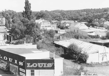
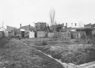
Photograph, Rear view of shops in Whitehorse Road, Ringwood, between Adelaide Street and Warrandyte Road - 1960
Written on backing sheet, "Back of shops in Whitehorse Rd. between Adelaide St. and Warrandyte Rd. Backyards L Roway 1960 (?) -
 Ringwood and District Historical Society
Photograph, Easterly view towards Warrandyte Road intersection, Maroondah Highway, Ringwood - 1974
Written on backing sheet, "Main St. looking east to Warrandyte Rd. 1974". -
 Ringwood and District Historical Society
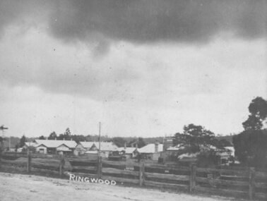
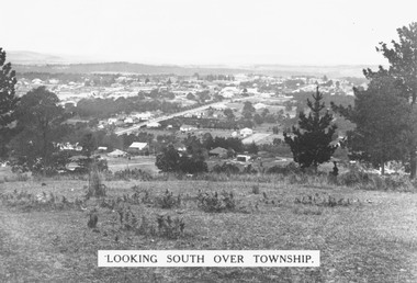
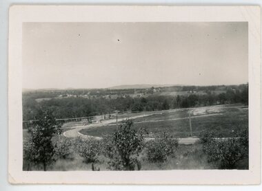
Photograph, Looking south over Ringwood township from Loughnans Hill c1930. Ringwood Street is the main road in the centre
Black and white photograph taken from hill overlooking township of Ringwood. (3 copies)Printed on photograph, "Looking south over township". Typed below photograph, "View from Loughnans Hill c1930. Ringwood Street is the main road in the centre. Old St. Pauls, railway crossing, Methodist church, state school, coolstores, etc. can all be seen". -
 Ringwood and District Historical Society
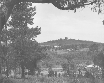
Photograph, View towards Loughnan's Hill overlooking Maroondah Hwy Ringwood from around Braeside Avenue area
... Hill from Andrew St. 1946". both incorrect - view overlooking..., "Loughnan Hill from Andrew St. 1946". both incorrect - view ...Typed below one photograph, "View towards Loughnan's Hill from Harrison St. 1946". Written below another copy, "Loughnan Hill from Andrew St. 1946". both incorrect - view overlooking Maroondah Hwy from around Braeside Avenue area. -
 Ringwood and District Historical Society
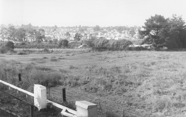
Photograph, View from railway line at Madden Street Ringwood, looking towards New St. Flower farm dam centre - to left. 1960
Typed below photograph, "From railway line at Madden St. looking towards New St. Flower farm dam centre - to left. 1960". -
 Ringwood and District Historical Society
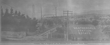
Photograph, View from where Heatherdale railway station is now situated, looking towards Ringwood - 2/2/1924. Land between Heatherdale Rd. and Madden St., sold 2nd Feb. 1924. J.B. McAlpin - agent"
Typed at bottom of photograph, "Panoramic view of Ringwood and the mountains, from Heatherdale Station Estate". Typed below photograph on mounting sheet, "View from where Heatherdale railway station is now looking towards Ringwood - 2/2/1924". "Between Heatherdale Rd. and Madden St., sold 2nd Feb. 1924. J.B. McAlpin - agent". -
 Ringwood and District Historical Society
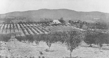
Photograph, View from Canterbury Road/Balfour Avenue area overlooking Martell's orchard, Heathmont, 1929
Black and white photograph of orchard. House in middle range, mountains in background. Photograph appears to be reproduced from subdivisional brochure. Note inserted in sleeve reads, "It has been pointed out that the mountains are to the east and the view is looking south. This therefore is not a 'straight' photograph. House still exists in Eden Avenue at October, 1996".(3 copies).Typed below photograph, "Panoramic view taken on the estate". "View overlooking Martell's orchard, Heathmont, 1929". Taken from corner Canterbury Rd. and Balfour Ave. looking south. Dandenong Creek just beyond house. Washusen Rd. on right". Written on back of one of the copies, "Heathmont Station Estate 1922". "Station Street, Lisgoold St. Canterbury Rd. Vivienne Cres. Balfour Ave." -
 Ringwood and District Historical Society
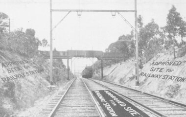
Photograph, Heatherdale Station Estate - 1924. Railway line and Approved Site for Railway Station
View of Railway Line and train, with labelling "Approved Site for Railway Station"Catalogue card reads, "Heatherdale Station Estate - 1924. 12 shop sites and 80 allotments. No deposit and 1 pound per month. 2nd Feb. 1924. J.B. McAlpin, agent. Situated between Heatherdale Rd. and Madden St. The station was erected in 1958." -
 Orbost & District Historical Society
black and white photographs, 1980s? (winter months)
All photographs seem to have been takenfrom the Telecom tower on the corner of Browning and Wolseley Streets in Orbost 3259.1 is a view of the Orbost township looking north-east. The swimming pool and bowling club can be seen in the foreground. 3259.2 is aview looking north-west and showing the tennis courts and clubhouse, the Recreation Reserve oval, the Youth Centre, Historical Museum, Municipal Offices, Senior Citizens clubrooms with the fire station in the foreground. 3259.3 is a view looking south with the Shire of Orbost Municipal offices and Ruskin Street in the foreground. Munro Street can be seen running from Ruskin Street to St Joseph's School in the middle distance. Lochiel Park oval, Lochiel House, the Snowy River and highway bridge are in the background. 3259.4 is a view looking south showing the Club Hotel, C.B.C. Bank in the middle distance and Hoffman's paddock (Forest Park) and the Snowy River beyond. 3259.5 is a view looking north-east over houses. 3259.6 is aview over the main street, Nicholson Street.showing the main shopping precinct. Shop signs for Permewans, Williams Shoes, F.B. Dicken and Orbost Bakery can be seen. 3259.7 is a view looking south west and shows Forest park and beyond towards Bete Bolong.These photographs are detailed pictorial records of the township of Orbost.Seven black / white photographs taken from above a township. Chimney smoke can be seen in the photographs.orbost-township-1980s aerial-photograph-orbost -
 Ringwood and District Historical Society
Photographs, Eastland Car park Construction, Ringwood, 1992-93
B&W photograph taken by Ringwood Historical Research Group. Also added extract from Melways showing the roads before the Bypass (1987) showing the planned Bypass cutting these two roads, and Melways (2018) showing new alignment with Bypass11064A: 21.2.92 Eastland car park development from near Safeway 11064B: 21.2.92 Eastland car park development from Adelaide St 11064C: 4.1.93 Eastland car park development from Warrandyte Road from Op. Bond St. 11064D: 4.1.93 New Myer Eastland car park viewed from Safeway's Roof 11064E: 17.1.93 Eastland car park near where Esso Garage was 11064F: 21.2.92 Eastland car park from cnr of Adelaide St and Eastland -
 Ringwood and District Historical Society
Photograph, Milton Street, Heathmont. 1952-3
Black and white photograph showing view from Milton Street. 1952-3"Written on back of photograph" Looking down on the Boulevard from 7 Milton St Heathmont. 1952-3 -
 Ringwood and District Historical Society
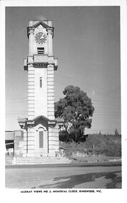
Photograph/Postcard, Postcard - Murray Views No.2 - Ringwood Main St and Clocktower in original position
Black and white "Murray Views" postcard - Ringwood memorial clock tower, cnr Maroondah Highway & Warrandyte Road, looking south towards railway line.Front: "Murray Views No. 2 Memorial Clock, Ringwood, Vic." Back: "1948" handwritten. "Real Photograph Produced in Australia by Murray Views, Gympie, Q." -
 Ringwood and District Historical Society
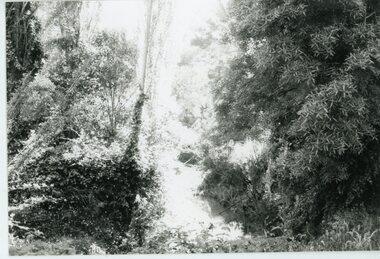
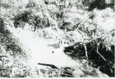
Photograph, Mullum Mullum Creek- 29-10-89
Black and white photograph"Written on back of photograph" Mullum Mullum Creek North bank view towards the West. Taken West of Harrison St.. Weed infested scrub on banks. -
 Ringwood and District Historical Society
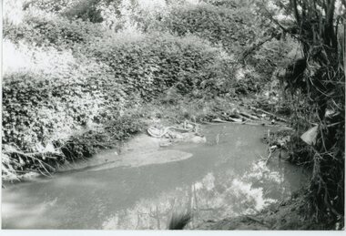
Photograph, Mullum Mullum Creek- 29-10-89
... bank West of Harrison St Rubbish and weeds - view generally... of photograph" Mullum Mullum Creek North bank West of Harrison St ...Black and white photograph"Written on back of photograph" Mullum Mullum Creek North bank West of Harrison St Rubbish and weeds - view generally to the East -
 Ringwood and District Historical Society
Photograph, Mullum Mullum Creek- 29-10-89
... North bank (Munro St side)View generally downstream West... of photograph" Mullum Mullum Creek From North bank (Munro St side)View ...Black and white photograph"Written on back of photograph" Mullum Mullum Creek From North bank (Munro St side)View generally downstream West of Harrison St Note rubbish and weeds. -
 Ringwood and District Historical Society
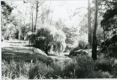
Photograph, Mullum Mullum Creek- 29-10-89
Black and white photograph"Written on back of photograph" Mullum Mullum Creek View downstream from North bank. A most pleasant part near New St (South bank) -
 Warrnambool and District Historical Society Inc.
Booklet, Centenary Souvenir of Christ Church Warrnambool, 1947
The booklet sets out the history of Christ Church Warrnambool from 1847-1947. The forward is by Vicar Ronald E Richards and the booklet outlines the history of the building of the church with special mention given to the stained glass windows. It covers other aspects of the history such as the vicars, choir, other church organizations and recreational facilities and service of the laity.A compact history of one of Warrnambool’s earliest and longest established churches. It provides a comprehensive listing of people and ministers who served the church and the community.Fawn coloured light card cover with black text and oval cutout showing photograph of front view of Christ Church. 16 pages.Printers: Kaye & Son Warrnambool.warrnambool, christ church, christ church warrnambool, centenary of christ church warrnambool,