Showing 55225 items
matching documents-maps
-
 City of Moorabbin Historical Society (Operating the Box Cottage Museum)
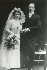
Photograph, B/W, x3 Wedding August & Frieda Rietmann 1910 and Certicicate, 1910,1915
August Rietmann (1877-1951) of Lustdorf ,Switzerland, married Maria Frieda Oesschlager (2/21878- 22/7/1942) of Baden Baden, Germany on 6/8/1910 In 1915 August and his wife Frieda migrated to Melbourne, Victoria, Australia. They leased Box Cottage, Ormond in 1917 and raised two children, Stefanie (1918 -2006) and William (1920- 1997). 1935 August purchased the property and the family used the Cottage during the day and slept in the Front House. August was a monumental mason, potter and sculptor, and was employed at Corbens Ltd Clifton Hill, to carve war memorials in Victoria post WW1 c 1915-1922. During the 1920's August set up his own business in pressed cement making pot plants, columns,paving slabs and lampstands. He continued to carve headstones and figures and took contract work for Artists eg Paul Mountford. He built a workshop in the Barn and used the Cottage for plaster moulding. His son William joined the business and and the family continued to use the site after August died in 1951. Rietman's Landscaping Ltd moved to Bay Road Highett in 1953 and later to Carrum. The land, containing the Box Cottage, was sold to Lewis Timber Pty Ltd in 1970 and Mr Lewis proposed that Moorabbin City Council should preserve the heritage Cottage. In 1984 the Cottage was dismantled and reconstructed in the adjacent Joyce Park.The Rietman family is an example of the diverse nationalities that lived and worked productively in Moorabbin Shire 1871–1933 , the City of Moorabbin 1934-1994 and continues today in the Cities of Glen Eira, Kingston, Bayside, and Monash. August, a sculptor and stone mason, was employed by Corben Pty Ltd Clifton Hill to carve WW1 Memorials before establishing his own successful masonry business in the Box Cottage during the latter 1920s. After becoming interested in pressed cement casting, he took on apprentices (1930s Depression) and among his products were garden furniture, pots and also street lamp standards, some of which were installed in St Kilda Road. After August’s death in 1951, his family continued the business ‘Rietman’s Landscaping Ltd.’, at Highett and Carrum.a) Photograph Black & White August & Frieda Rietmann Wedding 6/8/1910 in Baden Baden ; b) Passport Photograph August Rietmann 1915; c) Photograph Frieda Rietmann 1915; d) Document Wedding Certificate August & Frieda Rietmann Baden Baden 1910a) b) c) Handwritten information d) Official Document in Germanrietmann august, rietman august, rietmann frieda, rietman frieda, stonnington city town hall, war memorials, world war 1 1914-1918, rietman stefanie, rennick stefanie, francis stefanie, rietman william, rietman ray, mountford paul, malvern city town hall,box cottage museum ormond, box william, box elizabeth, joyce park ormond, rietman's landscaping pty ltd, bay road highett, macrobertson pty ltd, coleraine soldier memorial 1921, -
 Clunes Museum
Map - MAP OF CLUNES, FENTON CHARLES
THESE MAPS WERE SOLD IN CLUNES MUSEUM PRIOR TO TH REDEVELOPMENTOF THE WAREHOUSE BY HEPBURN SHIRE COUNCIL. MAPS WERE SOLD FOR $ 1.504 COPIES OF MAP OF CLUNES 1987map, clunes 1987, charles fenton, map of clunes -
 Peterborough History Group
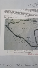
Document - Peterborough survey, Heytesbury District
About Peterborough town and the surrounding Council districts, coastal survey and mapshistory of the development of the townMaps, photocopiesflaxman hill, peterborough history, heytesbury, peterborough 3270 -
 Victorian Aboriginal Corporation for Languages
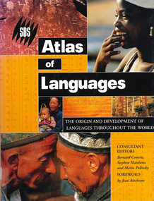
Book, Bernard Comrie, SBS SBS atlas of languages : the origin and development of languages throughout the world, 2003
... maps ...Over 30 full-colour maps, over 40 of the world?s major languages, language family trees, over 100 stunning full-colour photographs. A full glossary of linguistic terms.Maps, colour illustrations, colour photographslinguistics, maps, atlases -
 Warrnambool and District Historical Society Inc.
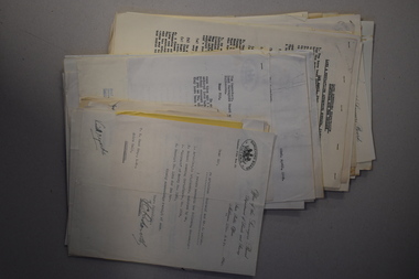
Documents, 1930s,40s,50s,60s
... Documents ...These documents came from the office of Rolf Crawley who was an engineer, surveyor and architect in private practice in Warrnambool and also the engineer for the Shire of Warrnambool from 1935 to 1968. His grandfather, father and uncle were also engineers, working in that capacity for the Shire of Warrnambool or as Secretary for the Shire of Warrnambool, with the Crawley family recording a total of 132 years of service to the Shire. The Shire of Warrnambool existed from 1863 to 1994. The documents came into the possession of Michael Hand who took over the Crawley surveying business in Warrnambool. The Warrnambool and District Historical Society acquired the documents, along with other Crawley memorabilia, from the Michael Hand Estate. These documents will be useful for reference and research, particularly in regard to the Shire of Warrnambool history.This is a packet of documents from the office of Rolf Crawley. They are mostly single sheets which include letters from the Office of the Surveyors Board, documents relating to employees and trainees and some Government papers. They are mostly typewritten with the signature of Rolf Crawley. There is one map of the Eumerella Drainage area.rolf crawley, warrnambool, shire of warrnambool -
 Bendigo Military Museum
Document - DOCUMENTS, DARWIN BOMBING, post WW2
Documents detail the first bombing raid on Darwin on 19 February 1942. Information related to subsequent raids also included..1) - .4) Collection of photocopied A4 documents related to the bombing of Darwin. 4 double sided pages in green plastic display folder. Black & white map & photos.documents - military history, passchendaele barracks trust, darwin -
 Kiewa Valley Historical Society
Map of the Ovens and Murray District of Victoria
The map features Beechworth and its history.This map features the north-east and in particular, Beechworth where residents of the Kiewa Valley may have shopped or visited for appointments.Black and white map with references to roads and gold. The centre of the map is Beechworth and in the bottom left side of the map is the heading Beechworth with 12 lines of print of information regarding Beechworth. The Kiewa Valley is not identified.beechworth -
 NMIT (Northern Melbourne Institute of TAFE)
Folder - CTS, Collingwood Technical College. College History. Part 2, 1960s
Part 2 Includes list of principals 1912-1970, correspondence re name change CTS to CTC. Lists/spreadsheets of staff(?) 1912-1985 at what appears to be staff meetings.A broad collection of information regarding the early years of CTS and CTC.Red plastic folder with plastic inserts.Cover title: "Collingwood Technical College / College History. Part 2". A variety of documents, media releases, correspondence, etc relating to the history of CTC and Collingwood Technical SchoolEach document has a numerical inscription relating to the Collingwood Technical School archives.collingwood technical school, cts, collingwood technical college, ctc, history, nmit, -
 Bacchus Marsh & District Historical Society
Map, Coimadai Parish Map, County of Bourke. Circa 1890s-1900s
The cadastral Parish of Coimadai, a subdivision of the County of Bourke, lies directly north of the township of Bacchus Marsh. The date of this map is uncertain. T.F. McGauran the person who made a photo-lithographic copy of the map was in charge of photo-lithography at the Victorian Department of Lands and Survey in the late 19th century until about 1910.A single page paper map showing the map for the Parish of Coimadai in the County of Bourke. A cadastral map showing parish boundaries and land ownership. A rectangle shaped area is missing from the centre of the map due to a tear or deliberate excision. The map is pasted into a bound volume containing 76 maps or plans in total. High resolution digital image stored on BMDHS computer network. Photo-lithographed at the Department of Lands and Survey, Melbourne by T.F. McGauran 26.8.[??] NOTE. Photo litho from L.P showing temporary surveys and occupation of land prepared for departmental use onlybacchus marsh region parish plans, coimadai parish maps, coimadai parish plan -
 Melbourne Tram Museum
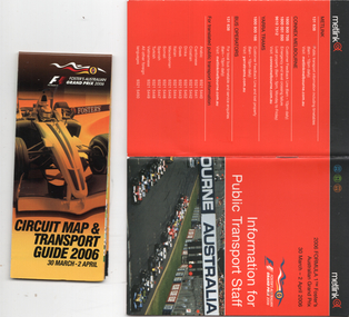
Booklet, Metlink, "Information for public transport staff - 2006 Formula 1 Australian Grand Prix", 2006
Gives details of event for train, tram and bus crews, event program and transport map, including shunting details, announcements, bus replacement services, electric or automatic points, route alterations. On the back cover has contact telephone numbers and web addresses - Published by Metlink. Fold out map gives a detail map of the course, locations for transport and details of the event - published by the Grand Prix corporation. Yields information the 2006 Grand Prix event at Albert Park.Set of 2 items - both within a clear plastic envelope. 1 - booklet 40 pages with foldout map centre stapled 2 - 16 fold map - circuit map and transport guide tramways, grand prix, metlink, formula 1, albert park -
Federation University Historical Collection
Plan (copy), Frederick Proeschel, Map of the Roads to all the Gold Mines in Victoria, 1853
The map was pirated from Frederick Proeschel's "Pocket Map of the Roads to all the Gold Mines in Victoria" issued earlier in 1853.Digital file of the Map of the Roads to all the Gold Mines in Victoria. The map has been coloured to show routes to the Victorian goldfields from Melbourne and Geelong.frederick proeschel, proeschel, gold, mining, philp -
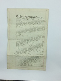 Port Welshpool & District Maritime Museum
Document, W.B.M. Smith et al, 2nd day of February 1899
Double foolscap document folded in quarters hand written with margins."Agreement document to let and hire steam ship "Mary" between Mr. C.E. Young with W.B.M. Smith, dated 1899." Further inscriptions refer to photos.steamship "mary"., agreement -
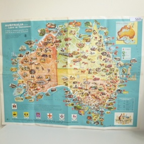 Greensborough Historical Society
Map, International Harvester, Australia. Land of tomorrow, 1965_
This 1960s map of Australia shows areas of economic development at that time.Colour map of Australiaaustralia economic development, international harvester -
 Creswick Campus Historical Collection - University of Melbourne
Map, Creswick, 1943
Dept of Lands and Survey map of Creswick and county of Talbot. 2 linen backed sheets rolled into white cardboard cylinderMaps -
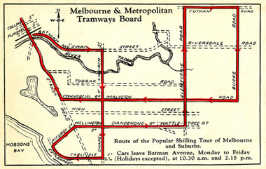 Melbourne Tram Museum
Drawing - Digital Image, Shilling Tour Map, 1927
Map shows the route of the Shilling Tour Map, using Y469 - shows the direction of travel and departure times from Batman Ave. Destination City 5th Edition notes that the services with the tram commenced in June 1927.Yields information about the MMTB's 1927 Shilling tour of Melbourne.Digital Image of an MMTB Map.trams, tramways, y class, tours, tourist trams, tourist trips, tram 191 -
 Bacchus Marsh & District Historical Society
Map, The Unique Advertising Combine, The Unique Combine's New Map of the Shire of Bacchus Marsh, 1890
This map was one of a number of similar maps produced for advertising purposes by a company called, 'The Unique Advertising Combine'. The company was located in Melbourne on Queens Walk. A brief item in the Bacchus Marsh Express newspaper on 29 March 1890 , page 2, indicated that subscribers to the Bacchus Marsh Express could obtain a copy of this map in the next issue of that newspaper. On the map is the detail that it was compiled by W.H. Bonney from official records supplied by D. A. Little, hire Secretary, (of Bacchus Marsh Shire).This map with its accompanying illustrations of local businesses and shops in Bacchus Marsh is an important documentary and visual snapshot of the town and district of Bacchus Marsh in the later part of the nineteenth century. The illustrations for some of the local businesses are the only known visual record of those particular buildings. The map is a rare surviving example of the material produced by The Unique Advertising Combine. Another similar example for the Shire of Mornington is held by the State Library of Victoria,A map of the Shire of Bacchus Marsh produced in March 1890. The map is mounted on a board and enclosed within a timber frame. The map includes an inset detail section showing the central part of the township of Bacchus Marsh including the main shopping and business streets. Land holdings with the first European land holders names indicated are included on the map. Rivers, creeks, major roads and the railway line are also shown on the map. Around the edges of the map are illustrated advertisements mostly for Bacchus Marsh businesses but which also includes some businesses located in Melbourne. maps bacchus marsh shire, shops bacchus marsh -
Beechworth Honey Archive
Map- Chiltern/Barnawartha
(4x) Map centred on Chiltern and Barnawartha. Shows Murray River, Hume Highway, Chiltern- Barnawartha Rd and Chiltern- Rutherglen Rd. Scale 1:50,000. Paper is white on back, yellow on front.Map labelled 'Albury series R652' Some markings in red and blue on some maps- blue writes '74-75'map, chiltern, barnawartha, paper, beechworth honey -
Victorian Aboriginal Corporation for Languages
Book, RMW Dixon, Australian languages: their nature and development, 2002
Very comprehensive technical linguistic introduction to the Australian language family, a follow-up to Dixon?s ?The Languages of Australia? (1980). Numerous maps, isoglosses, tables, comparative grammar, phonology, semantics, etc. 1. The language situation in Australia 2. Modelling the language situation 3. Overview 4. Vocabulary 5. Case and other nominal suffixes 6. Verbs 7. Pronouns 8. Bound pronouns 9. Prefixing and fusion 10. Generic nouns, classifiers, genders and noun classes 11. Ergative/?accusative morphological and syntactic profiles 12. Phonology 13. Genetic subgroups and small linguistic areas 14. Summary and conclusion.Mapslinguistics, language surveys -
 Eltham District Historical Society Inc
Book, Melway Great Melbourne street directory including Geelong, Phillip Island Healesville, Bellarine & Mornington Peninsulas, 1998
... maps ...25th edition. Coloured detailed maps accessed by a street or location index. Cover: (Includes) New Southbank map including Crown Complex, enlargements of Footscray and Kensington, bike paths, walking tracks & horse trails, latest public transport information, South east Australia tours maps, Vic Roads new route numbers, map of Australia1 atlas (22, 772 p.) : col. maps ; ISSN 03113957streets, maps, roads, melbourne -
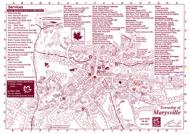 Marysville & District Historical Society
Map (Item) - Information map, Michael Hampton, 2000
An information map of the township of Marysville. This map was produced by McNamara Country Real Estate in 2000. The artist who drew the map was named Michael Hampton.An information map of the township of Marysville.MICHAEL HAMPTON/ 2000 VERSION 1:2/ 01/01marysville, victoria, australia, tourist map, information map, mcnamara country real estate, michael hampton -
 Bacchus Marsh & District Historical Society
Map, 'Map of Darley' circa 1877-1897
This map shows the early laid out streets and roads for the village of Darley and the main roads and streets in the central area of the township of Bacchus Marsh. The date of the map is not known. Landmarks indicated on the map including the Anglican Church in Church Street (Gisborne Road), opposite the Presbyterian Church, and the Baptist Church at its pre-1898 Main Street location suggest the map is dated between 1877 and 1897. Landholders names can be seen on some of the allotments of land marked in this map, including the names Clifton, Cosgrove, O'Hagan, McFarlane, Nagle, O'Hagan, Simpson and Vallence.A single page paper map showing the village of Darley and the township of Bacchus Marsh. Scale 10 chains to 1 inch. The map is pasted into a bound volume containing 76 maps or plans in total. High resolution digital image stored on BMDHS computer network. darley victoria maps, bacchus marsh victoria maps -
 Greensborough Historical Society
Map, Australia. Department of Minerals and Energy, Melbourne, topographic map, 1970_
A topographic map of Victoria with Melbourne as the centre. Provisional edition showing contours in feet. International map of the world [scale] 1:1,000,000. Prepared by the Department of Minerals and Energy, Canberra in 1970.A pre-metric map, shows the Hume Highway travelling through towns such as Seymour and Benalla, now by-passed by the Hume Freeway.Map, printed in colour on one side.victoria - maps -
 Greensborough Historical Society
Map - Map (Copy), C. Hodgkinson, District Surveyor et al, Parish of Yan Yean 1856: Village site during construction of the Yan Yean Reservoir, 1978
Copy of map part Sec. 13, Parish of Yan Yean 1856, Map 3, Village site... Scale: 8 chains to 1 inch. Drawn by C. Hodgkinson, District Surveyor, redrawn by A. R. Blair 1978. 1 p. photocopy of map. yan yean reservoir, yan yean -
 Warrnambool and District Historical Society Inc.
Map - Tourist Map Collection: Warrnambool & District Tourist Maps, Philprint, Warrnambool
This is a diverse collection of Tourist Maps for the Warrnambool & District area. [.1] From information on this guide it dates from the mid 1970's. It appears to not have been commercially printed and includes details of attractions no longer operating in Warrnambool such as Warrnambool Aquarium and the Oasis Reptile Park and Zoo. [.2] Commercially printed Warrnambool tourist map (c mid 1980's) surrounded by advertisements for local businesses. [.3] Commercial printed December 1991 tourist map of Warrnambool and District includes a competition entry form [.4] Commercially printed tourist map aimed at children [.5] Walking map of Warrnambool and District [.6] Commercially printed Warrnambool tourist map (c mid 1980's) surrounded by advertisements for local businesses. This collection of maps from the mid 1970's to early 1990's gives an insight into what was available to assist tourists find their way around Warrnambool and District. They include advertisements for business operating during this period and include lists of available accommodation, eateries, and tourist attractions.[.1] Tourist Attractions In and Around Warrnambool two foolscap pages with two sides of type written information of local and district attractions. There is a Warrnambool City map with points of interest marked and a hand drawn district map; [.2]Commercially printed grid map of Warrnambool City surrounded by advertisements from local businesses. Reverse side has a district map and a map of the Warrnambool CBD surrounded by advertising. [.3] Brochure including small grid maps of Warrnambool and district listing accommodation providers and places of interest. Stylised blue & bright green design of Norfolk pines and sea. [.4] Children's treasure hunt map to Warrnambool There are two examples, one with blue edging (Jan 1986) and one with red edging (Aug 1993) Both have a circular logo with a stylised whale and lighthouse [.5] Walking maps of Warrnambool blue printed photo of four tourists walking coastline on the front cover. [.6] Commercially printed grid map of Warrnambool with a bright yellow inset of Warrnambool CBD main shopping centre. The map is surrounded by advertising for local businesses.warrnambool, tourist maps, warrnambool businesses, warrnambool accommodation -
 Bacchus Marsh & District Historical Society
Map, Allotments in the Village of Rowsley, Parish of Gorrocburkghap, County of Grant c.1856
Rowsley is a locality 11 kilometers south-west of Bacchus Marsh. The date of this map is uncertain. A very similar map held by the State Library of Victoria (SLV) contains slightly more information than this copy and is dated as an 1856 map. SLV reference: 'Allotments in the Village of Rowsley, Parish of Gorrocburkghap, County of Grant', by T. Nixon, Assistant Surveyor, May 1856 ; Surveyor General’s Office, July 18 1856 (lithographed by R. Meikle). (1856). Melbourne: Surveyor General’s Office. MAPS 820 BJE 1837- ROWSLEY 1856. A single page paper map. A cadastral map of the Village of Rowsley in Victoria, showing numbered land allotments. 57 allotments are shown on the map and some areas set aside as reserves. Allotments 8, and 10-16 are outlined in red ink and allotment 9 has a cross in red ink on it. The map is pasted into a bound volume containing 76 maps or plans in total. High resolution digital image stored on BMDHS computer network. rowsley victoria history, rowsley victoria maps -
Beechworth Honey Archive
Map- Beechworth
Compiled from 1972 aerial photography. Printed in 1977.Map centred on Beechworth. SHows Beechworth toen, Wooragee, Reids Creek, Woolshed Falls and Lake Kerford. Scale 1:25,000 Printed colour on paper.Map labelled Reids Creek. No. 8225-3-1.map, beechworth, wooragee, reids creek, woolshed falls, lake kerford, aerial photography, paper, beechworth honey -
 Ringwood and District Historical Society
Map, Plan of the Parish of Warrandyte County of Evelyn - 1841
Blueprint copy of Survey Map W27 detailing original Selectors' names and property locations between Yarra Yarra River (Warrandyte) and Mullum Mullum Creek (Ringwood). List of Parish map references including property bearings, distances in Links, and markings on trees. Pound Bend area of Warrandyte marked as Reserve For Aborigines. Descriptive remarks include areas marked "scrubby, flat, sandy soil". Several other references faded and illegible.(Map) by T.H. Nutt Feb 3 1841. -
 National Vietnam Veterans Museum (NVVM)
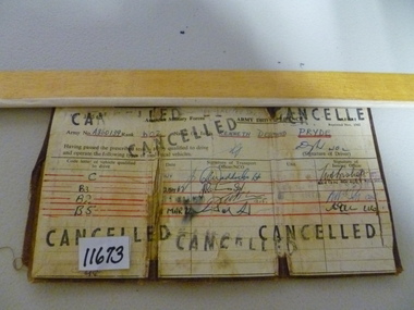
Document, Army Drivers Licence - Kenneth Pryde
Brown material covered cardboard folded in three Army drivers licence well used document detailing code letter of vehicle qualified to drive. Signatures of Officers/NCO noting four vehiclesArmy No: A860139, WO2 document No: 36543, Aust Military Forces. Reprinted Nov 1962drivers licence, kenneth desmond pryde -
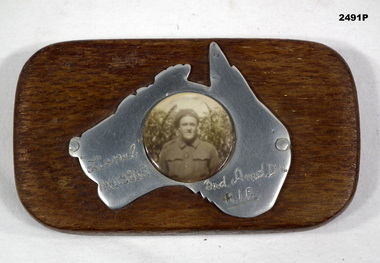 Bendigo Military Museum
Memorabilia - PHOTOGRAPH WW2, Post WW2
The soldier is Lionel Clarence Younghusband, initial enlistment No N199216, transferred to AIF No NX115868 age 22 years on 7.9.1942, date of death listed as 14.7.1943 while serving in 3rd ARMD DIV.Black & white photograph mounted on polished map of Australia mounted on timber rectangular stand. Photograph of a soldier in uniform.Hand inscribed on map - “Lionel NX115868 / 3rd Amd Div / AIF”photography-photographs, military history - souvenirs -
 Peterborough History Group
Document - Survey of Town of Peterborough, 2014
Proclamation of road district and Shires, Map of original town blocks and ad for SaleDisplays original township settlement and layoutPhotocopies, copies of maps, peterborough history, peterborough 3270