Showing 1588 items
matching farming.
-
 Kiewa Valley Historical Society
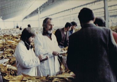
Photograph Tobacco selling, Tobacco sale floor, 1950 to 199
This promotional photograph by the Tobacco Growers Association was in response to a 1935 meeting of tobacco growers from Victoria, South Australia and Queensland which produced four major resolutions for the industry covering the remainder of the 1900s. These four resolutions were: (1) Adequate tariff protection (2) Control of pests and diseases (3) Orderly marketing (4) The formation of an advisory council of growers. History has produced the following results. (1) adequate tariff protection was never achieved,(2) control of disease through benzol vapour (CSIRO) breakthrough, was later identified as carcinogenic, (3) orderly marketing was achieved through (4) the establishment of the Tobacco Growers Association(19840. In October 2006, by way of Government buy back of tobacco leases from growers, resulted in the end of Tobacco farming in Australia (after 136 years of planting the first crop). It was also significant that the major tobacco companies such as Philip Morris and The British American Tobacco Australasia advised the industry that it would source its tobacco requirements overseas by 2009.This particular photograph shows prospective buyers (from the major processing firms of Philip Morris and British American Tobacco Australasia) inspecting the dried tobacco leaves at the Melbourne sales, before 2009, when they moved to overseas growers.The remnants of the Tobacco Industry can still be viewed throughout the Kiewa Valley and adjacent regions on the former tobacco farms, which still have the former tobacco drying sheds but now converted into hay sheds. The death of the tobacco industry(2006) resulted in the expansion of the dairy , sheep, beef cattle, venison and lama wool producers in the Kiewa Valley and surrounding regions. The problems from the large quantities of carcinogenic infused soil of farmlands in the region, still remains a problem now and for future generations. The tighter restrictions of where the final product can be smoked and the higher tax levied (no tariff protection) was the main contributor to this one time lucrative industry's demise.Coloured photograph pasted onto a thick wood chip backing. Two galvanised eyelets at the top of the frame, 50mm from each end, with a twine cord stretch from each, for hanging purposes. See also KVHS 0054A to KVHS 0054EA sign, which has been removed from the picture at some previous point in time is "Tobacco sale floor"tobacco, farming, rural industry, licences, ollie mould, blue mould, benzol vapour, photograph -
 Wangaratta RSL Sub Branch
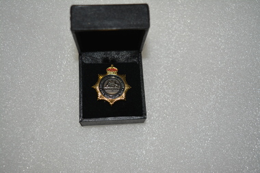
Badge - Boxed badge, 2012
Badge received by Dorothy Kiely in 2012 on the 70th anniversary of the Australian Women's Land Army. The Australian Women’s Land Army (AWLA) was formed during the Second World War to combat rising labour shortages in the farming sector. From December 1941, when Japan entered the war, the nation’s need to build up its armed forces was placed above the needs of other industries. Agricultural labour was steadily diverted to the armed services and war industry To meet the shortfall in rural labour, State and private women’s land organisations were organised, modelled on those established in Great Britain during the First and Second World Wars. A national body was formed on 27 July 1942 under the jurisdiction of the Director General of Manpower. While policy was devised by the Commonwealth Government, the organisation of the AWLA remained State-based. An extensive recruiting campaign was undertaken for new members. Most members of the existing land armies were later incorporated into the AWLA as well. Black box containing gold star shaped badge with red crown above Australian coat of arms Badge:-Australian Women's Land Army 70th Anniversary 2012 Box:- top in gold lettering 70th Anniversary of the Australian Women's Land Armyawla, ww2, dorothy kiely -
 National Wool Museum
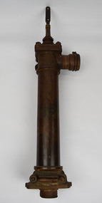
Tool - Water Pump, c.1960
A windmill may be considered one of the most iconic sights of Australian Farming life. A pump like this rest at the heart of all such windmills, turning wind energy into water for farmers both here in Australia and worldwide alike. The water windmills access is referred to as an aquifer, an underground layer of water trapped in rocks but accessible with use of water wells and windmills. Australia is home to an underground aquifer known as the Great Artesian Basin. It is the largest and deepest aquifer in the world. Stretching over 1,700,000 square kilometres, the Basin underlies nearly a quarter of the continent including most of Queensland, the south- east corner of the Northern Territory, the north-east part of South Australia and the northern part of New South Wales. The basin is 3,000 metres deep in places and is estimated to contain 64,900 cubic kilometres of groundwater. To try and give this number context, a megalitre is a million litres. The Great Artesian Basin contains 65,000 million megalitres of water. This would be enough to cover all the land on the planet in almost half a metre of water.Lift style piston pump typical of an Australian farm connected to a multi-bladed windmill. Bronze cylindrical construction coming up from removable wood base. Rotating lever is above outlet pipe which would send water to the storage tank.windmill, australian farming, great artesian basin, aquifer -
 Linton and District Historical Society Inc
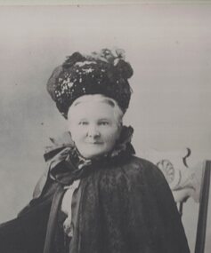
Photograph, Eliza Kennedy
Born about 1838, Eliza Brophy married Thomas Kennedy - an early Linton police officer, a Shire of Grenville councillor, and later a landowner/grazier - in 1861. Eliza and Thomas Kennedy lived in Linton from about 1865 to 1885, and then were at Portland from 1885 to 1892, after which Thomas Kennedy retired from police work to pursue farming and other interests. The Kennedys lived at their property "Fingal Park" (at Spring Vale, later called Pittong) until about 1907-08, when they built a house, named 'Kin-Kora", next to the Catholic Church in Cumberland Street, Linton. Eliza and Thomas Kennedy had thirteen children. The first five children are shown in a photograph taken outside the Linton Court House, c.1869-1870. (See Registration no. 2017-93). Eliza Kennedy died in 1915. An obituary for her published in the 'Grenville Standard', 25 September 1915, notes that "through her genial and happy disposition, she endeared herself to the whole community."Enlarged copy of original black and white photograph which has been mounted on white card. The photograph shows an older lady dressed in dark clothing, wearing a hat, cape and gloves. She is seated on a wooden chair, with her right hand resting on an occasional table, on which are vases of flowers. Eliza Kennedy (Mrs Thomas Kennedy), née Brophy.eliza kennedy née brophy -
 Federation University Historical Collection
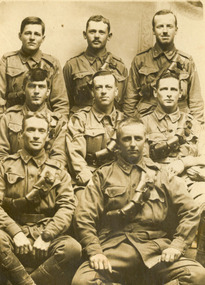
Photograph - World War One soldiers, Members of 18th Company Australian Army Service Corps, c1916
HENRY SMERDON (Harry) HOLMES was born in 1897 at the family property, ’Sauchieburn’, 17 km north of Ballarat, in the Ascot district. He was the youngest of four children. After finishing his education at St Patrick’s College, Ballarat, Henry joined the Holmes family farming interests. At the age of 18 he enlisted and served with AIF in Egypt, France and Belgium 1915-1918. Henry served at the famous battlegrounds of Ypes and Somme in the Australian Army 8th Battalion. He was a Driver with the 4th D.A.C. The postcard is of "The Ascot" boys. Includes [Samuel] Gordon Spittle, Henry [Harry] Holmes's first cousin, and other Ascot lads and district connections: neighbours, Ascot State School classmates and football mates from Clunes / Creswick districts. [Research by a granddaughter of Henry Smerdon Holmes, Jane Dyer (nee Chatham) 2024] Ray Blight and Gordon Les Sim were former students of the Ballarat School of Mines. Les Sim was associated with Sim and Co. hardware and wood merchants). Eight soldiers of the AIF. They are the tent mates of Harry Holmes a Driver with the 5th D.A.C. The names of the soldiers are John Raymond (Ray) Blight, Joseph Fawcett, John Joseph (Jack) Nase, Gordon Spittle, Harry Holmes, Harold Joseph Reid, James Leslie (Les) Sim, Leslie John Walters. handwritten in pen on verso "This is a snap of our tent mates. Reading left to right. Back row, Jack Nase, Joe Fawcett, H. Reid. Middle - Les Walters, Ray Blight, Gordon Les Sim, (Sim and Co wood merchants) and Harryworld war 1, chatham, jack nase, chatham family archive, joe fawcett, h. reid, blight, sim, les walters, ray blight, gordon les sim, pickford, world war, gordon spittle, harry holmes, les sim, horace pickford, world war one, aif, armed services -
 Federation University Historical Collection
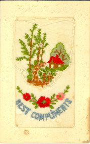
Postcard, Silk Embroidered World War One Postcard, c1917
Australian World War One Soldier memento. This postcard was possibly sent home from France during World War One, most probably from Harry Holmes of Ascot, Victoria. HENRY SMERDON (Harry) HOLMES was born in 1897 at the family property, ’Sauchieburn’, 17 km north of Ballarat, in the Ascot district. He was the youngest of four children. After finishing his education at St Patrick’s College, Ballarat, Henry joined the Holmes family farming interests. At the age of 18 he enlisted and served with AIF in Egypt, France and Belgium 1915-1918. Henry served at the famous battlegrounds of Ypes and Somme in the Australian Army 8th Battalion. He was a Driver with the 4th D.A.C. The postcard is of "The Ascot" boys. Includes [Samuel] Gordon Spittle, Henry [Harry] Holmes's first cousin, and other Ascot and Tourello lads and district connections: neighbours (including a Wrigley boy), Ascot State School classmates and football mates from Clunes / Creswick districts. (Research by Jane Dyer) Postcard with embroidered detail on white silk, with top flap. The central embroidery depicts two small soldiers dressed in brown outside a gate leading to house in a peaceful setting surrounded by trees. Below is a blue embroidered "Best Compliments" and red embroidered garland of red flowers.chatham family collection, chatham, world, war, world war one, world war 1, world war i, france, harry holmes, holmes, embroidery, postcard -
 Phillip Island and District Historical Society Inc.
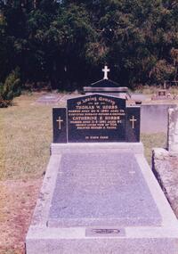
Photograph Album, Kodak, Phillip Island Cemetery, c 1990
The Album was compiled by Nancy McHaffie late 1990's, with the assistance of Edith Jeffery's, with her book "Garden of Memories" and extensive knowledge of Phillip Island. The Cemetery lies back from the road and is surrounded by Manna Gums, rare Peppermint Gums, Blackwoods and other native trees. In all 25 acres of land were set aside as Crown Land in the land settlement of 1868. There are 6.2 acres of wetlands near the cemetery entrance.466-42: Thomas William Hobbs BEM. Thomas was born in England and came to the Island in the 1920's to work for the Chicory Farmers. He later owned his own farm at Ventnor and won the Better Farming Competition conducted by the Phillip Island Council. He was always an active community worker. Thomas was a Councillor and served two terms as President. He was the only resident to be awarded the British Empire Medal, Civil Division, for services to Phillip Island. Thomas died 1980 aged 75. His wife Catherine died 1991 aged 87. 466-43: Matilda Richardson. Matilda was born at Kyneton on 12th July 1865 and came to Cowes with her parents in 1869. She attended Cowes Primary School with her brothers and sisters. She became ill in November 1872 and died on 10th February 1873 aged 8 years and 7 months, from a severe bout of Quinsy. It was a great sadness to the family and they went to a lot of trouble to secure Matilda a fine grave in the cemetery. It is the oldest grave in the cemetery and a lasting memorial for her short life.phillip island cemetery, cr. hobbs, matilda richardson grave, nancy mchaffie, edith jeffery -
 Kew Historical Society Inc
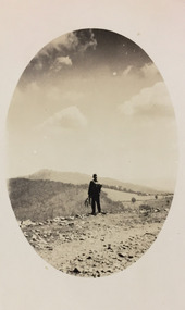
Photograph - Rural landscape, c.1926
Henry Beater Christian (1886-1962) , was a descendant of one of the earliest settler families in Kew. Employed at the Kew Asylum as a 'public servant', he was a skilled amateur photographer, photographing numerous scenes in Kew and on his travels around Victoria. The majority of his photographs date from 1916 to 1929. His finest photographs are housed in two photograph albums. Digital copy of a photograph from page 17 of the 47-page photograph album containing 261 gelatinous silver images, loaned by Diane Washfold with permission given to digitise and hold a copy in our collection. This photograph, dating from c.1926, forms part of a group of photos preceding images of [Black] Spur, so the photographs may have been taken as part of that bushwalking trip. John Chapman has written in 'Bushwalking Clubs - A Brief History', about the establishment in Victoria of the first bushwalking club in 1888, and the popularisation of bushwalking during the interwar period. Henry Christian's 'walks' appear to have been undertaken solely or with a companion/s. This camera shot invites the viewer to access the landscape through the point-of-view of the man standing with his back to the camera at the edge of the road. The man holds leaves in his left hand [to deter insects], and has a knapsack on his back. The landscape in the distance includes both cleared land for farming and remnant vegetation. The oval framing device was used when Henry Christian developed the photo.Illegible ink inscription on pagehenry beater christian (1886-1962), landscape photography, kew (vic.) — yarra river, christian-washfold collection, photograph albums, bushwalking -- victoria -
 Wodonga & District Historical Society Inc
Photograph - Fred Rochow Railways Collection - Railway Commissioner Harold Clapp and Mrs. Clapp, 1938
The Fred Rochow Railways Collection incorporates photos related to the operation of the Wodonga Railway Station including different types of trains and railways staff C. 1930 – 1990. It was donated to the Wodonga Historical Society by Fred Rochow, a railwayman who spent many years based in Wodonga. He joined the Victorian Railways on 17th June l947 and retired in 1988. For some time, he was a member of the Australian Federated Union of Locomotive Enginemen and served a term as a member of the Trades Hall Council. He had an extensive knowledge of the struggles that took place to achieve better conditions for railway workers. Fred worked for many years as a fireman and then worked his way up the ranks to driver, experiencing many changes from the days of steam locomotives through to diesel trains, locomotives and even the modern XPT train. He worked throughout Victoria at different stages of his career, with his final working years focused on the northeast of Victoria and the Albury to Melbourne line. After his retirement, Fred continued to share his love of steam miniature trains with the community.This collection has local and statewide significance as it captures images of trains, locomotives and personnel who operated the railway services in Wodonga and throughout Northeast Victoria. The railways played a critical role in opening up Victoria and connecting Australia for trade, business, social communication and transport.Railway Commissioner Harold Clapp and Mrs. Clapp ready to leave Albury on the "Spirit of Progress" in 1938. The Driver is George Lynch Snr. and the Fireman is E. Finley. Sir Harold Winthrop Clapp (7 May 1875 – 21 October 1952) was a transport administrator with the Victorian Railways who over the course of 30 years revolutionised the railways in Victoria. Clapp introduced faster services and more powerful locomotives, supported the farming sector and presented a report on standardising rail gauges which then led to a uniform rail gauge across capital cities. His most well-known project was the upgrade of the Sydney Limited service into the all-steel, all-air-conditioned, non-stop, high-speed express streamliner, Spirit of Progress which was launched on 17 November 1937. Clapp became Chairman of Commissioners of Victorian Railways in 1920 and remained Chairman until his retirement in 1951. Harold W Clapp was appointed a Knight Commander of the Order of the British Empire (KBE) in 1941 in recognition of his contribution to public service.railways wodonga, fred rochow, wodonga railwaymen, s class locomotive -
 Eltham District Historical Society Inc
Photograph, Edendale Farm, Eltham Heritage Tour, 24 May 1992, 24/05/1992
ELTHAM HERITAGE TOUR The Society excursion on 24th May 1992 was arranged by David Bick, leader of the team carrying out the Shire's heritage study. David selected a number of sites or buildings identified in the study, some of them lesser known components of the Shire's heritage. The tour commenced at the Eltham Shire Office at 10.00 am. Travel was by private car and mini-bus with stops at about twelve locations for commentary by David.It included a short walk in Hurstbridge and lunch at Kinglake. Highlights of the tour included: - 10 am Leave from Shire Offices - 3 Important Trees - A Physical Link to Eltham's First Settlers - Toorak Mansion Gates - A Surviving Farm House - An Intact Circa 1900 Main Street - First Settlers - Gold Miners, and Timber-getters - An Early Hotel - A Pioneering Homestead - Changing Eltham Shire - 20th Century - 4 pm Afternoon Tea and Finish Tour Extract from ELTHAM CULTURAL HERITAGE TOUR (Newsletter No. 85, July 1992, by Bettina Woodburn) "The land was unprofitable for intensive farming, but there was always water in the Diamond Creek. The railway, a technological advance, followed the valley, and was provided to transport produce. At North Eltham we were privileged to tour a surviving farmhouse of the 1860-70 era at the Shire’s Edendale Farm, with the as yet unfinished Sculpture for a front fence - bulbous tree-trunks decorated with salt pots, with cross members from the old trestle bridge. As was usual these six veranda posted houses faced South (or East, away from the sun!) with the scullery, kitchen and pantry "out the back". The veranda, which must have been very narrow, no longer exists. It probably wrapped around three sides. The drive took us past the Dutch Windmill, only twenty years old and in the Shire of Diamond Valley, then the Diamond Creek Cemetery with impressive gateway, to a detour to see another old farmhouse, isolated on a hill off Murray Road Wattle Glen. Here was a particularly thick patch of exotic planting of pines and cypresses. Subsistence farming no longer pays. Following the rail-line we noticed on the left near Silvan Road an Edwardian cottage and on the right near Yates Road the old school residence for this Upper Diamond Creek area."Record of the Society's history and activities and highlighting various aspects of the Heritage Study undertaken by David Bick used to create the future heritage overlay for the Shire of Eltham and later Nillumbik Shire.Roll of 35mm colour negative film, 4 stripsKodak Gold 100 5095eltham, shire of eltham historical society, activities, heritage tour -
 Eltham District Historical Society Inc
Photograph, Edendale Farm, Eltham Heritage Tour, 24 May 1992, 24/05/1992
ELTHAM HERITAGE TOUR The Society excursion on 24th May 1992 was arranged by David Bick, leader of the team carrying out the Shire's heritage study. David selected a number of sites or buildings identified in the study, some of them lesser known components of the Shire's heritage. The tour commenced at the Eltham Shire Office at 10.00 am. Travel was by private car and mini-bus with stops at about twelve locations for commentary by David. It included a short walk in Hurstbridge and lunch at Kinglake. Highlights of the tour included: - 10 am Leave from Shire Offices - 3 Important Trees - A Physical Link to Eltham's First Settlers - Toorak Mansion Gates - A Surviving Farm House - An Intact Circa 1900 Main Street - First Settlers - Gold Miners, and Timber-getters - An Early Hotel - A Pioneering Homestead - Changing Eltham Shire - 20th Century - 4 pm Afternoon Tea and Finish Tour. Extract from ELTHAM CULTURAL HERITAGE TOUR (Newsletter No. 85, July 1992, by Bettina Woodburn) "The land was unprofitable for intensive farming, but there was always water in the Diamond Creek. The railway, a technological advance, followed the valley, and was provided to transport produce. At North Eltham we were privileged to tour a surviving farmhouse of the 1860-70 era at the Shire’s Edendale Farm, with the as yet unfinished Sculpture for a front fence - bulbous tree-trunks decorated with salt pots, with cross members from the old trestle bridge. As was usual these six veranda posted houses faced South (or East, away from the sun!) with the scullery, kitchen and pantry "out the back". The veranda, which must have been very narrow, no longer exists. It probably wrapped around three sides. The drive took us past the Dutch Windmill, only twenty years old and in the Shire of Diamond Valley, then the Diamond Creek Cemetery with impressive gateway, to a detour to see another old farmhouse, isolated on a hill off Murray Road Wattle Glen. Here was a particularly thick patch of exotic planting of pines and cypresses. Subsistence farming no longer pays. Following the rail-line we noticed on the left near Silvan Road an Edwardian cottage and on the right near Yates Road the old school residence for this Upper Diamond Creek area."Colour photograph1992, culture, edendale, edendale community farm, events -
 Orbost & District Historical Society
poem, Mallacoota
The poem, "Mallacoota", as in this copy, does not appear to be noted in any of the lists of poems attributed to Henry Lawson. NOTE: Information provided by David Williams on 13/12/2021 is that "this poem in your collection is by Edward Harrington (indeed not Lawson)". Edward P Harrington (1895-1966) was born in Shepparton, served in Palestine in W W I with the 4th Light Horse Regiment, tried farming, but his lifelong passion was for story-telling through poetry. He is described as the 'last bush balladist' in Australia, and was a close friend of E J Brady and John Shaw Neilson. It was likely that he came to Mallacoota as a guest of E J Brady who had a camp for writers and poets there. He produced 5 collections of verse: Songs of War and Peace; Boundary Bend and Other Ballads; My Old Black Billy and other Songs of the Australian Outback; The Kerrigan Boys and other Australian Verses; and Swagless Swaggie and Other Ballads.His "Mallacoota" poem is printed in the Swagless Swaggie collection (1957). https://adb.anu.edu.au/biography/harrington-edward-philip-10431 Poetry associated with a place in East Gippsland. A copy of a printed poem titled "Mallacoota" with unknown author. It is pasted onto a cardboard backing. Although attributed to Henry Lawson in this printed copy, information is that it is by Edward Harrington.poem - edward harrington - bush balladist - mallacoota -
 Eltham District Historical Society Inc
Photograph, Charles and Annie Cockcroft in front of their grocer shop and attached house, cnr of York Street and Main Road, Eltham, c.1935
Charles Cockcroft born Bundanoon, NSW, 1885, died 1966 and Annie Cockcroft (nee Green) born Lismore, NSW, 1881, died 1943. They are buried together in Eltham Cemetery. On 28 Nov 1931 C.R. Nicholls offered for auction the General Store and attached house he had built on the corner of York Street and Main Road in late 1925. The property was purchased by Charles and Annie Cockcroft from which they lived and ran their grocery business. Following the death of Annie in 1943, and prior to 1949, Charles sold the business and moved farming at Jeeralang North near Traralgon in Gippsland. References: • 1931, 1943 and 1949 Electoral Rolls (Ancestry.com) • Eltham. (1926, January 15). Advertiser (Hurstbridge, Vic. : 1922 - 1939), p. 2 (AFTERNOON). Retrieved February 23, 2022, from http://nla.gov.au/nla.news-article56659270 • Auction Sale at Eltham (1931, November 20). Advertiser (Hurstbridge, Vic. : 1922 - 1939), p. 5. Retrieved February 23, 2022, from http://nla.gov.au/nla.news-article56736611Black and white print also negative copy of print (roll of 35mm black and white negative film, 3 strips Ilford FP4)Details inscribed in blue ink on back of photoannie florence cockcroft (nee green), car, charles burgess cockroft, feed store, general store, grocer, grocers, main road, shops, vehicles, york street -
 Orbost & District Historical Society
ledger, late 1950's - 1970's
This ledger was used by the Shire of Orbost in the late 1950's - 1970's.The item was donated to Orbost & District Historical society from P.R.O.V. as a Place of Deposit (POD) item for safe keeping by a local history group or museum. The shire covered an area of 9,347 square kilometres and existed from 1892 until 1994 when it became part of the East Gippsland Shire Council. Orbost was at first included in the Bairnsdale Shire from 1882 and was later part of the Tambo Shire. Because of travelling distances the Croajingalong Shire was created in 1892 (name changed to Orbost Shire 17.2.1893 with James Cameron as the first Shire President. In 1994 it amalgamated to become part of East Gippsland Shire Council. The Country Roads Board was the government authority for the construction and maintenance of main roads in Victoria between 1913 and 1983. It was succeeded by the Road Construction authority on 1 July 1983 and later merged with the Road Traffic Authority on July 1 1989 to form the Roads Corporation. James Cameron, an Orbost farming pioneer and Member of the Legislative Assembly, fathered the Country Roads Board This item is a hand-written record of Orbost Shire Council accounts. It pre- dates computer records. The Shire of Orbost local council no longer exists having been absorbed by the East Gippsland Shire Council.A black ledger with wooden covers. It contains hand-written records of transactions between Orbost Shire Council and the Country Roads Board.bottom left corner - Orbost in black on a white East Gippsland Shire logoledger accounts shire-of-orbost country-roads-board -
 Surrey Hills Historical Society Collection
Photograph, Dr Blakie's home and surgery, 171 Union Road, Surrey Hills
The photo would have been taken prior to 1913 as Dr Blakie moved across the road to 174 Union Road to a purpose-built home/surgery designed by architect Arthur Plaisted. He practised at 171 Union Road joining or taking over from Dr Percy Liddle in 1905. The property was rented from the Zeplin family who built the house in 1890, which was known as 'Edgeware', and originally owned all the land bound by the railway, Union Road, Wilson Street and Montrose Street. in the 1920s to 1930s. 1906 became the home of Dr James Blakie, surgery was to the left of house. In 1912 Blakie had house built opposite (now Medical Centre). In 1920s-30s 'Edgeware' became Surrey Hills Police Station. Family details: James Blakie was born in New Zealand to a farming family of Scottish origin. He trained at Otago University with additional study at Cambridge. He married Catherine Miller Martin in 1906. They had 4 children: Geoffrey Noel (1906-1955); Raymond James (1907-1989); Theodore (1913-1913) and a daughter.Black and white photo of a Victorian style home with a slate roof, 2 chimneys, and a striped corrugated iron front veranda to 2 sides with decorative iron fretwork. It has a picket fence and an established garden with a central path leading to the front door. A woman, identified as Nurse Jones, is standing on the veranda.victorian style, homes, edgeware, house names, union road, montrose street, surrey hills, police station, zeplin family, professor zeplin, doctors, medical services, nurses, nurse jones, dr james landells blakie, dr percy liddle, mrs catherine miller blakie, raymond james blakie, geoffrey noel blakie, surrey hills police station, arthur plaisted, architects, edgeware, house names, 1890-1900 -
 Warrnambool and District Historical Society Inc.
Journal - Ledger, Bostock 1856-1886, Circa 1856
Augustus Bostock was the 9th child of Robert & Rachael Bostock of Vauclause Epping Forest, Van Diemen’s Land. He was only 4 years old when his mother died. He was inspired by his father to seek his fortune in the Western District of Victoria. He arrived around 1850. He married Margaret Aitkin in July 1865. Augustus owned several properties in the district and leased others. He sat on the court of Warrnambool, Mortlake or Hexham as required. He resided at Marramook in Hawkesdale and later moved to Vauclause in Hopetoun Road Warrnambool.where he died in 1920 at the age of 87. He was involved in many aspects of life in the Western District, racing, cricket, and social acitivities to name a few. This ledger shows the expenses and costs associated with the farming business of Augustus Bostock, one of the earliest pioneers of Warrnambool. It lists names of people with whom he did business as well as expenses with shearing and rations. It lists the various categories of sheep, ewes, lambs, wethers, and different breeds of sheep and distinguishing features of cattle. It also contains the names of local shearers and workers.Augustus Bostock was one of the earliest pioneers of Warrnambool and the Western District. This ledger gives an insight into many aspects of this early life. It therefore has social, historical and interpretive significance.Hard cardboard coverer with cream covering. Line border on front cover. Mottled green, blue and pink paper inside front and back covers. Alphabetical index at front. 105 pages.warrnambool, bostock, angus, diary -
 Bendigo Historical Society Inc.
Book - JOAN O'SHEA COLLECTION: 150TH ANNIVERSARY OF BENDIGO BOOKLET, 1850 - 1950's
Joan O'Shea Collection. Buff Coloured Booklet City of Bendigo. 150th anniversary of Bendigo 1850s to 1950s. Image on cover coat of arms for City of Bendigo underneath word progress, left hand side horse, right hand side bullock. History of Bendigo: From Sheep Run to Provincial City in 100 years. Map of Bendigo and Surrounds Railways, Water Courses & Storage, Power, Municipal Boundaries & Land Available for Industry. Municipal District Creation 1855, Borough Proclamation 1863, Proclaimed City 1871, Area: 7992 Acres Population as of last census City of Bendigo 28,722, City of Bendigo and adjacent Urban Areas 36,909. City of Bendigo Map, The Past Prior to 1850. Icons of Bendigo The Bendigo base Hospital,Law Courts & Post Office, Primary Schools, Housing, Industry including Butter Production, Poultry Farming, Livestock Sales & Tomato Growing, Slaughter House & ordnance factory. The Present Recreation Photos: Bendigo Bowling Club, Queen Elizabeth Oval, Municipal Lawn Tennis Courts The Future of Bendigo, Bendigo Photographs From The 1950s,Cambridge Press Bendigobendigo, history, progress of bendigo 1850s on. -
 The Beechworth Burke Museum
Audio - Oral History, Jennifer Williams, Mr Herbert McFeeters, 4 May 2000
Herbert McFeeters as born in Wooragee Creek in 11th July 1905. Mr McFeeters would walk to school in Beechworth by foot, about 3.5 miles through the hills. It would take him and his siblings one hour to get to school. Mr McFeeters worked at the local tannery from the age of 14 for 11 years. After which he worked for himself, farming cattle and selling milk around the region. Mr McFeeters bought land from the Crown, who were selling lands after many miners had left the region. Mr McFeeters recalls the Chinese community that remained the Beechworth area and the social activities in the town, including the pictures, football games and Harvest Festivals. This oral history recording was part of a project conducted by Jennifer Williams in the year 2000 to capture the everyday life and struggles in Beechworth during the twentieth century. This project involved recording seventy oral histories on cassette tapes of local Beechworth residents which were then published in a book titled: Listen to what they say: voices of twentieth century Beechworth. These cassette tapes were digitised in July 2021 with funds made available by the Friends of the Burke. Mr McFeeters oral history provides detail of life in rural Victoria during the early 20th Century. Mr McFeeters describes his early childhood and working life, including details of the social activities This oral history recording was part of a project conducted by Jennifer Williams in the year 2000 to capture the everyday life and struggles in Beechworth during the twentieth century. This project involved recording seventy oral histories on cassette tapes of local Beechworth residents which were then published in a book titled: Listen to what they say: voices of twentieth century Beechworth. These cassette tapes were digitised in July 2021 with funds made available by the Friends of the Burke. This is a digital copy of a recording that was originally captured on a cassette tape. The cassette tape is black with a horizontal white strip and is currently stored in a clear flat plastic rectangular container. It holds up 40 minutes of recordings on each side.Mr Herbert McFeeters /listen to what they say, beechworth, oral history, burke museum, herbert mcfeeters, wooragee creek, reid's creek -
The Beechworth Burke Museum
Audio - Oral History, Mrs May Harris, July 2000
This oral history interview was conducted with Mrs May Harris (née Peach), who grew up in the farming town of Stanley, about 9km southeast of Beechworth. Mrs Harris moved to Melbourne and got work cleaning houses before getting married. Her husband worked on farms, and the couple eventually found their way back to Stanley. She describes experiences of illness, particularly her husband and children's experience with asthma and the impact that had on their lives and careers. Mrs Harris talks about local fundraising events in Stanley, particularly what she calls 'Australian Teas', as well as some of the dances and picnics that were major sources of entertainment when she was young. This oral history recording was part of a project conducted by Jennifer Williams in the year 2000 to capture the everyday life and struggles in Beechworth during the twentieth century. This project involved recording seventy oral histories on cassette tapes of local Beechworth residents which were then published in a book titled: Listen to what they say: voices of twentieth century Beechworth. These cassette tapes were digitised in July 2021 with funds made available by the Friends of the Burke.Mrs May Harris' statement explores life in a small farming community alongside some of her life in the city, which might provide an interesting comparison. She discusses the difficulties of facing illnesses in these rural communities, noting the lack of available resources and need to travel to Beechworth. She discusses community events, highlighting both the social aspects and the fundraising aspects.This is a digital copy of a recording that was originally captured on a cassette tape. The cassette tape is black with a horizontal white strip and is currently stored in a clear flat plastic rectangular container. It holds up 40 minutes of recordings on each side.listen to what they say, beechworth, oral history, burke museum, illness, asthma, farming, farm work, rural life, stanley, stanley athenaeum, sinclair's sawmill, sawmill, the great depression, housework, australian tea, fundraising -
 Orbost & District Historical Society
certificate, 30th January 1903
This certificate was issued on January 30, 1903 to Captain Alan Richardson by the Marine Board of Victoria entitling her to carry 25 passengers and only 10 passengers when engaged in towage service. Two children under 12 years of age to be reckoned as one passenger. The penalty of 20 pounds would be levied if these limits were exceeded. the certificate was valid until 21st July 1903. The original Paddle Steamer Curlip was built by Sam Richardson and his sons Mark, Albert and Frank, at their sawmill at Tabbara, a pioneering settlement on the Brodribb River, a tributary of the Snowy River. Curlip's keel was laid on 14th October 1889 and PS Curlip was launched in 1890. The Paddle Steamer Curlip was designed to travel up and down the Snowy and Brodribb Rivers with essential supplies from coastal ketches and schooners, that plied their trade up and down the coast between Melbourne, Sydney and Tasmania. The Curlip regularly towed one or two barges and up to five barges loaded with local farming produce and timber for the thriving cities, that was loaded offshore or in the Snowy River estuary, tide and depth permitting, on to the trading vessels.This item is associated with the P.S. Curlip and the Richardson family, early Orbost pioneers.A paper passenger certificate for a river steam ship.Details are handwritten in black and red ink.curlip-p.s. certificate-passenger richardson -
 Warrnambool and District Historical Society Inc.
Certificate - Federation Celebration Rolfe invitation, 1901
This invitation to a ‘Conversazione’ to celebrate the Federation of the six colonies in Australia into the six States of Australia in 1901 was sent to the invitees after the event to keep as a souvenir of the occasion. The event was hosted by the Government of Victoria. The certificate was designed by George Brougham Austin, a Melbourne architect and artist employed by the Victorian Department of Public Works. He also designed many of the public decorations displayed in Melbourne during the Federation celebrations. Austin’s original work was lithographed by an artist at Sands and McDougall, Melbourne. This particular invitation was sent to George Rolfe and his wife, Annie. George Rolfe (1836-1919), a tea merchant from Melbourne, began buying blocks of land near the mouth of the Hopkins River in Warrnambool in the 1870s. By the early 1880s he owned 50 acres of land in the town and some nearby farming properties. He used the building on the ]and near the mouth of the Hopkins River as holiday accommodation and called the property, Lyndoch. He improved the property with the additions of stables, jetty, boathouse, bone and chaff sheds, reservoir and windmill and extensive gardens. Rolfe spent most of his later life at Lyndoch. Today the property is the site of an Aged Care facility. This certificate is of considerable importance for two reasons: 1. It is an important and attractive memento of a signal event in the history of Australia – the Federation of the States in 1901. 2. The certificate was an invitation to Mr and Mrs George Rolfe. George Rolfe was a prominent Warrnambool person in the late 19th and early 20th centuries. This is a multi-coloured certificate printed on a cream-coloured card. The certificate has an image of the Exhibition Building surrounded by an ornate border of heraldic shields, portraits of the Duke and Duchess of Cornwall and York, views of the six capital cities of Australia, native flora and fauna, the Royal Crest and the Crest of Australia. The names of the invitees are handwritten in black ink. ‘United Australia 1901 One Flag One Hope One Destiny Australian Commonwealth Celebrations’ ‘The Government of Victoria requests the honor of the presence of Mr & Mrs G. Rolfe at a Conversazione in the Exhibition Building on the Evening of Tuesday 7th May 1901 at 8 p.m.’ george rolfe of lyndoch, warrnambool, federation of australia, history of warrnambool, george rolfe -
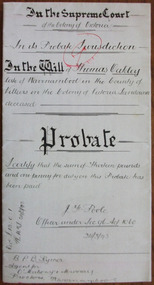 Warrnambool and District Historical Society Inc.
Document - Thomas Oakley Letters of Administration 1898, 1893
Tait collection: item 39 of 62 This document gives the details of the Will and Probate of Thomas Oakley who died in Warrnambool at the age of 75 in 1893. He had come with his first wife to Australia in 1852 and was a Customs Officer in Warrnambool, in charge of the signals and premises, living in Merri Street. Later after the death of his wife (they had ten children) he married Eliza McKeeman in 1870 and they lived at ‘Oakbank’ near the Warrnambool Cemetery where Oakley pursued farming interests. They had a further eight children, many of them making their mark in the business and community life of Warrnambool and further afield. Thomas Oakley left real estate to the value of £900 and personal estate to the value of £1251, with the beneficiaries being his wife, his daughters, Elizabeth and Mary Anne from his first marriage and the eight children of his second marriage. The lawyers concerned with this document, O’Mahony and Murray, had offices in Warrnambool in Kepler Street at the end of the 19th century and the beginning of the 20th century. This document was in the possession of Ernest Chambers, a Warrnambool lawyer during the same period. It was then passed down to successive lawyers occupying the Kepler Street premises and located there in 2014.This document is of considerable importance as it gives details of the Will and Probate of Thomas Oakley, a prominent and successful landowner in Warrnambool in the 19th century. It will be of great use to researchers. This is a white piece of thick paper folded in two with handwritten material on four sides of the paper. The pages have printed red lines at the edges of three pages. The document contains details of the Will and Probate of Thomas Oakley who died in 1893 in Warrnambool. The pages are clean and readable.In the Supreme Court of the Colony of Victoria in its Probate Jurisdiction in the Will of Thomas Oakley late of Warrnambool in the County of Villiers in the Colony of Victoria Landowner deceased.o’mahony & murray,, warrnambool lawyers, ernest chambers, warrnambool lawyer, thomas oakley, tait collection -
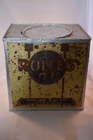 Warrnambool and District Historical Society Inc.
Household, Tea tin, Late 19th century
This tin comes from the Melbourne firm of Rolfe and Co. and would have held tea. Rolfe & Co. was established by George Rolfe (Senior) in 1854 as a wholesale wine, spirit and provisions business. George Rolfe was a member of the Upper House of the Victorian Government from 1860 to 1862 and in 1867. He died in 1871 and his son, also George, succeeded him as the managing director of the business. This George Rolfe (1837-1919) came to Australia with his family in 1849 and lived first in South Australia and then came to Melbourne, joining his father’s business, George Rolfe was a keen farmer and fisherman and after holidaying in Warrnambool for some time, bought, in the early 1870s, the property at the mouth of the Hopkins River which he named Lyndoch after the town in South Australia. He came frequently to Warrnambool. He later extended his farming interests which included the properties of Fairy Hill and Shipley. George Rolfe married Jane Ann Lake in 1891 and the Lyndoch property passed to two of his stepdaughters. Today the Rolfe property is the site of an aged care facility. The business of Rolfe & Co. continued well into the 20th century.This tin is of great interest as a memento of George Rolfe of Lyndoch, Warrnambool and his Melbourne business, Rolfe & Co. George Rolfe was a prominent person in the Warrnambool district in the late 19th and early 20th centuries. This is a metal container, rectangular in shape. It originally held tea. The sides of the tin have painted lettering regarding the contents and the supplier. This paint was originally in yellow, blue and brown tonings. The lid is round and slots into the rounded opening. The tin has been re-painted in a silver colour on the top and inside. The tin, especially the lettering on the sides, is much rusted and in some places the words are illegible. A small hole has been pierced in the top of the tin‘Rolfe’s Tea’ ‘Rolfe & Co. Ltd 300 King Street Melbourne’ rolfe & co, george rolfe senior, george rolfe junior, lyndoch, warrnambool -
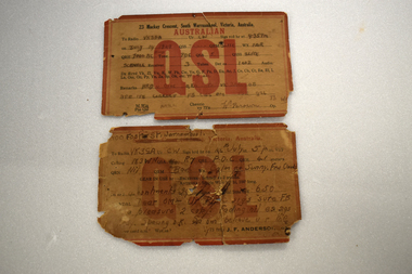 Warrnambool and District Historical Society Inc.
Card - Amateur Radio Cards, 1929
These two cards have been sent In 1929 by two early Warrnambool amateur radio persons to William (Bill) Douglas, an amateur radio person with the call sign, VK3GA. The cards are QSL cards, sent as a result of radio contacts being made between two amateur radio persons. Bill Douglas (1898-1986) was a Victorian schoolteacher who was the first licensed amateur radio person in the Otway Ranges district. He was licensed in January 1929 and these cards refer to radio contacts in the July of that year. The cards do not feature the call signs of the contacts but were standard cards used by amateur radio people who did not have personalised cards at the time,. One card was sent by J.F. Anderson (VK3WN) whose address at the time was 100 Foster Street, Warrnambool. He was possibly connected to the family of James and Jane Anderson who lived for some time in Foster Street but later went farming in the Nullawarre district. The other card was sent by W. Brown of 23 Mackay Crescent South Warrnambool (call sign unknown). No information has been found on this person.These two cards are of some importance as they are very early examples of amateur radio operations in Warrnambool. .1 A rectangular card, very faded and torn at edges. The card has a red border and red and black printing and handwritten material. On the back is a handwritten letter. .2 A rectangular card, very faded and torn at the edges. The card has a red border and black and red printing and handwritten material. On the back are a postal franking stamp, a green postage stamp and a handwritten address.1 a handwritten letter .2 Radio VK3GA Lavers Hill Victoriaamateur radio stations, w. douglas vk3ga, j.f.anderson vk3wn, w.brown warrnambool -
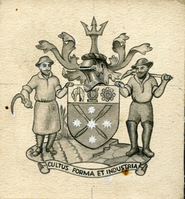 Federation University Historical Collection
Drawing - Artwork - Drawing, Jeff Zilles, ZILLES COLLECTION: City of Ballarat Coat of Arms, c1975
The following research was undertaken for the Coat of Arms in the foyer of Ballarat Civic Hall, painted by Angus Henderson. The Ballarat arms were granted on 10 May 1956. The shield is supported by a farmer and a miner and topped by a trident (referring to Britannia and aquatic sports) with sprigs of wattle and begonias either side. The crossed oars against the Eureka flag refer to rowing events in the 1956 Olympic Games. The importance of farming and industry are shown by the sheep and cogwheel while the lyre reflects the City’s commitment to the arts and Royal South Street Society, which contributed to the design of the Civic Hall. The name Ballaarat came from two Aboriginal words: balla and arat, meaning ‘resting place’. At the time of Council amalgamations, May 1994, Ballarat became the name of the new Council. The Latin motto: Cultus: cultivation, care, worship Formar: form, shape, appearance Industria: diligence, activity, industry Zilles Printers was begun by Lewis Zilles in the early 1930s. It was in McKenzie Street Ballarat. His son Jeffrey also became a printer - letterpress, offset and screen printer. The business became Zilles Printers/Graphics and was in Armstrong Street and later Bell Street Ballarat.Small Ballarat coat of armscity of ballarat coat of arms, crest, zilles printers -
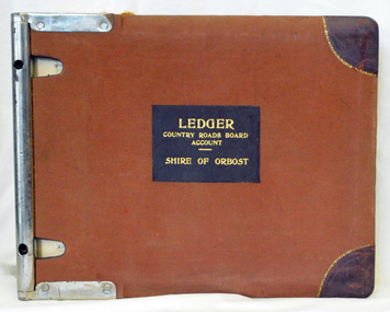 Orbost & District Historical Society
ledger, 1950's -1960's
This ledger was used bt the Shire of Orbost local government to record Country Roads Board accounts 1950's and 1960's. The item was donated to Orbost & District Historical society from P.R.O.V. as a Place of Deposit (POD) item for safe keeping by a local history group or museum. The shire covered an area of 9,347 square kilometres and existed from 1892 until 1994 when it became part of the East Gippsland Shire Council. Orbost was at first included in the Bairnsdale Shire from 1882 and was later part of the Tambo Shire. Because of travelling distances the Croajingalong Shire was created in 1892 (name changed to Orbost Shire 17.2.1893 with James Cameron as the first Shire President. In 1994 it amalgamated to become part of East Gippsland Shire Council. The Country Roads Board was the government authority for the construction and maintenance of main roads in Victoria between 1913 and 1983. It was succeeded by the Road Construction authority on 1 July 1983 and later merged with the Road Traffic Authority on July 1 1989 to form the Roads Corporation. James Cameron, an Orbost farming pioneer and Member of the Legislative Assembly, fathered the Country Roads Board. This ledger is a hand-written record of accounts for the Orbost Shire local council. It pre-dates computer records. The Orbost Shire Council no longer exists having been absorbed into the East Gippsland Shire Council.A heavy brown coloured ledger with covered wooden covers. it has steel metal binding. Inside are strips of paper marking pages. It contains blue ink hand-written records of monies in/out (?) to Shire of Orbost Council. On the front cover inside a black rectangle in gold print is " LEDGER COUNTRY ROADS BOARD ACCOUNT ORBOST". It is an "Emu Binder".ledger orbost-shire accounts country-roads-board