Showing 1253 items matching "land sale"
-
 Glen Eira Historical Society
Document - Maroondah, Glen Eira Road, 379, Caulfield North
An auction brochure for the sale of Maroondah, 379 Glen Eira Road, Caulfield, undated, auction occurring on 29/05/1937 contains details on the location, land, rooms and outbuildings. Back of brochure has a handwritten illustration of a floor plan. Black and White photograph of the house printed also.maroondah, doolan bertha o., shelferd curls’ church of england school, glen eira road, hawthorn road, grumnade house boys’ church of england school, caulfield north, r. harley & co., house names, caulfield racecourse, verandahs, architectural features, caulfield park, caulfield grammar school, garages -
Glen Eira Historical Society
Frogmore Estate
A black and white photograph (140mm x 90mm) of a real estate advertisement for the sale of housing blocks on the residential development Frogmore Estate, Murrumbeena. The advertisement includes a plan showing the location of the housing blocks and the surrounding roads.murrumbeena, carnegie, frogmore estate, neerim road, gnarwyn road, coorigil road, moonya road, woornack road, rosstown railway, carool road, warina road, murrumbeena road, frogmore road, wahgoo road, hethersett grove, hethersett, thomas, j g, plans, housing estates, rosstown, caulfield council, land subdivision -
 Eltham District Historical Society Inc
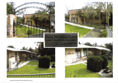
Document - Folder, Eltham War Memorial Complex, 1961
Background context for the establishment of the Eltham War Memorial as a living memorial, championed by the women of the community with the establishment of the Eltham War Memorial Trust and how the memorial was funded by public donations and eventually handed over to Council. The essay came about in 2018 following community protest at Council's plans to sell the land. Following abandonment of the sale process and putting development on hold, community groups pulled together to apply for heritage protection of the site with Heritage Victoria. This was formally rejected in May 2020.Contents: An essay addressed to the Councillors of Nillumbik Shire, October 2018: About the Eltham War Memorial and the adjacent community-owned sites in Eltham that the Council threatens to sell, Andrew Lemon Nov. 2018 Public Notice: Heritage Act 2017, Recommendations to the Heritage Council, Heritage Council Victoria, The Age, May 22, 2020, p34eltham war memorial, eltham war memorial trust, mrs. ada lyon, mrs. cairns officer, mrs. j.j. morrison, andrew lemon, children's library, eltham war memorial garden, eltham war memorial gate, eltham war memorial hall, garden of remembrance, heritage council victoria, nillumbik shire council, theodore feldbauer, violet feldbauer (nee teagle) -
 Eltham District Historical Society Inc
Document - Newspaper clipping, "The lap of luxury; Blending into Eltham environ", Property Age, The Age, Wednesday 24 June 1998, p5, June 1998
Both of the architects involved in the 2.4-hectare Kinloch Gardens parkland development in Arthur Street, Eltham, are now living on the estate. The project was conceived by Eltham architect Ian Jelbart, whose family has owned the land for more than 100 years, and fellow architect Graeme Gunn, who in the 1960s was one of the creators of the Merchants Builders concept that set new trends in Melbourne housing. The $5 million project is based around two of the original buildings, on what was once a 100-hectare farm owned by the Jelbart family. Ian Jelbart always intended to continue living in the original homestead building, and now Graeme Gunn has moved into the big residence that once was the barn. Kinloch Gardens is designed to combine the more manageable land sizes increasingly demanded by buyers with ample "internal space, flexible floorplans, privacy and individuality of designs. Individual houses are placed on small separate allotments around an area of private parkland. The aim is to ensure total privacy, offer virtually unlimited views and parkland vistas, and remain aesthetically compatible with the local environment. Homes in four basic designs over either two or three levels are being sold off the plan, with prices ranging from the high $200,000s to the high $300,000s. Two have already been sold. Indication of land-only values The prices being asked for some vacant blocks offered for private sale provides an enlightening comparison of the relative "land only" values for homes sites in various areas. A 751 sq metre block on a new residential estate in Bentleigh/Carnegie is offered at $235,000, equivalent to $312/square metre; while in Merrett Drive, Williamstown, a 561 sq metre allotment offered for $169,000 carries a rate of $301/sq metre. In Barnsbury Road, Balwyn, the $450,000 price tag on a 584 sq metre allotment equates to $770 sq metre; and in York Street, Richmond, a 198 sq metre postage stamp is priced at $230,000 or $1162/sq metre. - Rex BookerDigital file only; created from scan undertaken by EDHS of item on loanarthur street, eltham, graeme gunn, houses, ian jelbart, jelbart property, kinloch gardens, rob maclellan, robert marshall, woodridge estate -
 Eltham District Historical Society Inc
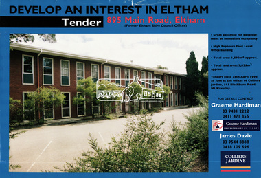
Document, Tender Documents for purchase of Former Eltham Shire Offices 895 Main Road, Eltham, April 1996, 1996
Graeme Hardiman Real Estate Prepared for Nillumbik Shire Council Maddock Lonie & Chisholm, 140 William Street, Melbourne Tenders closed at 3.00pm on 24 April 1996 Whilst the sale of the former Shire Office site went through and the Shire Commissioners approved the demolition of the building several months later in the year, ongoing community protests and objections eventually led to the reversal of the sale. Despite several further attempts to sell the site and community protests as recent as 2019, the vacant land remains in Council ownership.89 A4 pages; 1 x glossy paper with photo and 88 x photocopied pageseltham shire office, graeme hardiman first national real estate, maddock lonie & chisholm, nillumbik shire council, real estate, tenders -
 Lara RSL Sub Branch
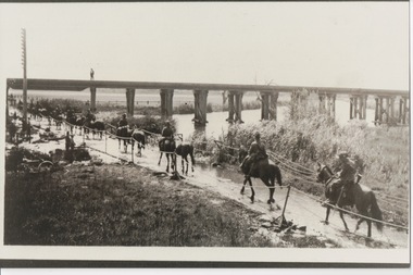
Photograph, Set 4 photographs. and others for Torquay Light Horse camp, 1940
These images capture for all time Light Horsemen travelling through Geelong on their way to camp at Torquay for the last Group meeting in Australia . information following - details obtained from .........https://torquayhistory.com/light-horse-brigade/ On Australia Day, 1997, Sir John Young unveiled this plaque on Point Danger, Torquay. Torquay history, Light Horse Training Camp, WW2 Plaque at Pt. Danger Note----- (See images to view plaque) The plaque identifies a significant event in Torquay’s history and the sentiments of ‘change’ for the Light Horse Brigade – from horses to machines. In 1940 the four Light Horse Regiments (4th, 8th, 13th and 20th), some 5000 Light Horse and 2000 horses camped and trained at Torquay. Three other regiments, formerly mounted on horses, were also at Torquay ‘mounted’ on privately owned trucks and cars. Division troops included Artillery, Engineers, Signals, Field Ambulance and other branches of the Army necessary to enable a Division to function. It wasn’t just the sheer numbers of men coming to this little town that made the event significant, it was also the fact that the men of the Light Horse were dramatic, almost glamorous figures and it is easy to see their exploits as some splendid adventure. Horses have played a special role in the story of Australia. They were the only means of transport across this huge country, so it was necessary for everyone to have the ability to ride a horse. When war broke out in 1899 between Britain and the Boers of South Africa (“Boer” was Dutch for “farmer”) Australia sent troops to fight. At first Britain was wary of using untried, unprofessional colonial cavalrymen but soon saw that the slouch-hatted Australian “bushmen” were a match for the fast-moving and unconventional mounted commandos of the Boers. The Australians proved themselves to be expert rough-riding horsemen and good shots. Bush life had hardened them to go for long periods with little food and water. They also showed remarkable ability to find their way in a strange country and use its features for cover, in both attack and defence. By 1914, when Australia joined the war against Germany, there were 23 Light Horse regiments of militia volunteers. Many men from these units joined the Light Horse regiments of the Australian Imperial Force (AIF). Men were given remounts (if not using their own horses) – army horses bought by Commonwealth purchasing officers from graziers and breeders. These were called “walers” because they were a New South Wales stockhorse type – strong, great-hearted animals with the strains of the thoroughbred and semi-draught to give them speed, strength and stamina. On 1st November, 1914, Australia’s First Infantry Division and the first four Light Horse regiments sailed for England in a fleet of transport ships. The first of the Light Horse arrived at Gallipoli in May without their horses. Back with their horses after Gallipoli, they were formidable combatants across the Sinai and Palestine. Some British commanders observed that the light horseman moved with a “lazy, slouching gait, like that of a sleepy tiger” but described how the promise of battle “changes that careless gait, into a live athletic swing that takes him over the ground much quicker than other troops”. They had Light Horse, Torquay, training campdeveloped a reputation as formidable infantrymen. The Turks called them “the White Ghurkas” – a reference to their deadly skill with the bayonet. The Arabs called them “The Kings of the Feathers”. The plume had originally been a battle honour of the Queensland Mounted Infantry for their work in the shearer’s strike of 1891. During WW1 it was adopted by almost all the Light Horse Regiments. It was the proud badge of the light horseman. The most famous of their battles was the attack on Beersheba- the charge of the 4th Light Horse Brigade. Mounted infantrymen and their superb walers had carried out one of the most successful cavalry charges in history – against what seemed impossible odds. They surprised the Turks by charging cavalry-style, when they would normally have ridden close to an objective then dismounted to fight. The fall of Beersheba swung the battle tide against the Turks in Palestine; and changed the history of the Middle East. While 19 men from the Surf Coast Shire served with the 4th Light Horse over the course of WW1, only four were involved in the charge of Beersheba- John GAYLARD, Philip QUINN.(Winchelsea); Wallace FINDLAY (Anglesea); Harry TRIGG (Bambra). After the war, Light Horse units played a key role in the Australian Government’s compulsory military training programme. The Citizen Military Forces (C.M.F.) thrived on the glamour of the wartime Light Horse tradition, ignoring the possibility that motor vehicles would soon replace the horses. When training was no longer compulsory, the C.M.F. regiments declined and horses became more of a luxury during the 1930s depression years of poverty and unemployment. Some regiments were motorised. Then, in 1939, Australia joined Britain in another world war. Training was increased for the militia at both home bases and regional training camps. The camp at Torquay in 1940, commanded by Major General Rankin, was at Divisional strength. By the end of the camp some felt that the Division was ready for active service. Gradually, over the next four years, the Australian Light Horse units were mounted on wheels and tracks and the horses were retired. Six men enlisted at the Torquay camp and another 57 men and women enlisted at Torquay for service in WW2. Those who served in the Militia provided valuable Officers and NCOs and men for the armed services during the war. Each infantry division of the 2nd AIF had a Light Horse regiment attached to it. But the day of the Australian mounted soldier hadn’t quite passed. During World War II, Australia’s 6th Cavalry Regiment formed a mounted unit they called “The Kelly Gang” which did valuable scouting work. In New Guinea, a mounted Light Horse Troop did patrol duty and helped carry supplies. Some fully equipped walers were flown into Borneo for reconnaissance in rugged mountain country. But by the end of the war, in 1945, the horse had disappeared from the Australian Army. References: Australian Light Horse Association www.lighthorse.org.au National Australia Archives Australian War Memorial Surf Coast Shire WW1 memorials www.togethertheyserved.com The Light horse- a Cavalry under Canvas Light Horse, Training Camp, Torquay, WW2 Late in 1939 it was decided to set up a Lighthorse training camp in Torquay to train both men and horses for the battles of the Second World War. Horses, men and equipment came on special trains from all over Victoria and NSW, and as you would expect horseman came from areas such as Omeo and Sale, the Wimmera and the Western District. They arrived at the Geelong racecourse for watering in the Barwon River and then were ridden across the ford at the breakwater and began their 11 mile trek to Torquay. Light Horse, Training Camp, Torquay, WW2 Tent city By the end of January 1940 the camp at Torquay accommodated some 5000 men and 2500 horses of the Second Cavalry Division. The rows of horses, tents and huts near Blackgate Road were quite a sight. While the cavalrymen engaged in exercises on the land and on the beaches, many of the troops took over the Torquay School for special training of men and officers. Mr Bob Pettit local farmer and Councillor for the Barrabool Shire, wrote about the Light horse in the Surf Coast Community News in 1985 saying “They used to travel about the district riding four abreast in one long convoy. To my annoyance they went through my property and shut all the gates behind them. I had certain gates open to let stock in to the water holes and it would take me three -quarters of an hour to follow the horsemen up and put all the gates right again” he continued “the men from the Light Horse were here when the fire went through in March 1940. He recalled an incident when early one morning, as some one blew the bugle, a soldier putting a white sheet on the line frightened the horses. They panicked and ran off in all directions. Six went over the cliff near Bird Rock, five were never found, and the rest were gathered up after nearly a fortnight in the bush around Addiscott and Anglesea" Light Horse, Training Camp, Torquay, WW2, Geelong Parade Geelong parade The training camp culminated in a parade through the streets of Geelong on March 12th 1940. The salute was given at the Town Hall and the troops continued on a route to the You Yang’s for a training exercise. Note-----(see media section for photograph) The Camp was abandoned in mid 1940 as it was deemed unsuitable for training during winter and the cost of a permanent camp could not be justified if it could not be used all year. Historic.......Rare,,,Interpretive.Sepia photographs.set of four ....post card size ....Horses &LighthorsemenNo 1, Lighthorsemen Regiment Geelong 1940......No 2 Light Horse at Breakwater Geelong 1938 to 1940....No 3 Light Horse at Breakwater Geelong 1938 to 1940.....No 4 Light Horse crossing Breakwater camped at Geelong Showgrounds. These markings are on reverse of photographs.light horsemengeelong 1940., world war 2 -
Federation University Historical Collection
Book - Book - Scrapbook, Ballarat School of MInes: Scrapbook of Newspaper Cuttings, Book 9, August 1980 to January 1981
Collection of newspaper articles related to Ballarat School Of Mines.They cover activities and advertisements for staff. The papers concerned are The Courier, Ballarat, The Australian, The Age over the period of 09/08/1980 to 15/01/1981.Book with white cover back, front, spiral bound. staffing advertisements, courses available, metal trades industry association award, stephen jackson, unemployed youth program, majority didn't like school, motor mechanic apprentice brendan nunn, racv award, women's conference, secretarial careers day at smb, department of labor and industry, safety award to sec apprentice ross homberg, theatre group needs more members, challenging forum-ballarat melbourne rail link, role of councillors, bricklaying apprentices given tool kits, sir redmond barry, the man who sentenced ned kelly to death, bricks sale to aid smb building, ballarat sandblasting, o'flaherty, smb recreationbuilding appeal, smb link with barry centenary, smb art display, smb 110th birthday, bcae is 10 years old today, decade of growth at smb repeated 100 years later, intensive course for apprentices, priceless relics gather dust, aboriginal world war 1 collection, smb land laboratory opening, lee anton wins photo prize, students moving from tafe college to tertiary education, smb council move for tafe centre, engineering course change defended -
 Flagstaff Hill Maritime Museum and Village
Document - Map, Department of Lands & Survey, Victoria / Panmure, 1942
This Emergency Edition of the map of Panmure, Victoria, is part of the W.R. Angus Collection. It was printed in 1942 during World War II. It is one of two maps donated to Flagstaff Hill Maritime Village by the family of Doctor William Roy Angus, who served as Surgeon Captain in the Australian Defence Department. The map was compiled for the Dept. of Army by the Dept. of Lands and Survey in Melbourne, prepared by the Australian Section of the Imperial General Staff, which was a British Government body created in 1907 to co-ordinate the defence of Britain and its Empire. It was printed by A.H.Q. Cartographic Company, Survey Corps, which was formed in 1941. The Corp changed its name to L.H.Q. Cartographic Company of Bendigo. In 1947 the name reverted back to the A.H.Q. Cartographic Company until 1955 when it became the A.H.Q. Survey Regiment. The W.R. Angus Collection includes historical medical equipment, surgical instruments and material once belonging to Dr Edward Ryan and Dr Thomas Francis Ryan, (both of Nhill, Victoria) as well as Dr Angus’ own belongings. The Collection’s history spans the medical practices of the two Doctors Ryan, from 1885-1926 plus that of Dr Angus who began practice in 1924. Dr. Angus served with the Australian Department of Defence as a Surgeon Captain during the Second World Was from 1942 to 1945. He served in Ballarat, Victoria, and in Bonegilla, N.S.W. until he suffering from a heart attack just before the war ended. ABOUT THE “W.R.ANGUS COLLECTION” - Doctor William Roy Angus M.B., B.S., Adel., 1923, F.R.C.S. Edin.,1928, was generally known as Dr Roy Angus. His working life included a position as a doctor with the Flying Doctor Service in Australia’s rural and remote areas. After many varied experiences Dr Angus and his family moved to Warrnambool in 1939 where he purchased “Birchwood,” the 1852 home and medical practice of Dr John Hunter Henderson. He was appointed on a part-time basis as Port Medical Officer in Warrnambool and held this position until the 1940’s when the government no longer required the service of a Port Medical Officer. Dr Angus was a surgeon at the Warrnambool Base Hospital 1939-1942. After further studies he commenced practice as an ophthalmologist in Warrnambool, pioneering in artificial eye improvements. He was Honorary Consultant Ophthalmologist to Warrnambool Base Hospital for 31 years and made monthly visits to Portland to perform eye surgery. Dr Angus and his wife Gladys were very involved in Warrnambool’s community with a strong interest in civic affairs. They were both involved in the creation of Flagstaff Hill Maritime Village, including the layout of the gardens. After his death on 28th March 1970 his family requested his practitioner’s plate, medical instruments and some personal belongings be displayed in the Port Medical Office surgery at Flagstaff Hill Maritime Village, and be called the “W. R. Angus Collection”. This Emergency Edition of the Map of Panmure is significant as an example of the documents prepared for the defence of Australia in World War 2. The Map is also significant for its connection between the Australian Army and the involvement of Dr WR Angus as a Surgeon in the Medical Services during World War II. The W.R. Angus Collection is significant for still being located at the site it is connected with, Doctor Angus being the last Port Medical Officer in Warrnambool. The collection of medical instruments and other equipment is culturally significant, being an historical example of medicine, administration, household equipment and clothing from late 19th to mid-20th century. Dr Angus assisted Dr Tom Ryan, a pioneer in the use of X-rays and in ocular surgery. The collection includes Dr Angus’s Army objects and is significant as an example of items issued to Doctors and Surgeons in the Medical Services of the Australian Army in World War IIMilitary map of Panmure, Victoria, Australia; part of the W.R. Angus Collection. Rectangular coloured map on cream paper for the Australian Army. Details include sea, waterways and land, contour lines, grid lines, names of districts, towns and roads, bridges, swamps, rail lines, cuttings, tracks, buildings (including blacksmiths), pumps, lighthouses, telegraph, telephones and electric transmission lines, and fire stations. The map has margin notes that include distances in miles to nearby towns. The map was compiled for the Dept. of Army by the Dept. of Lands and Survey in Melbourne, prepared by the Australian Section, Imperial General Staff and printed by A.H.Q. Cartographic Company, Melbourne in 1942. Crown Copyright Reserved. Inscriptions in red print state that it is and Emergency Edition and an Official document. An oval purple stamp includes the price.Printed in black; 'Victoria / Panmure", "No. 930 / Zone 6" Printed in red; “EMERGENCY EDITION”, “THIS MAP IS AN OFFICIAL DOCUMENT. IF FOUND, IT MUST BE HANDED / IN TO THE NEAREST MILITARY HEADQUARTERS OR POLICE STATION” Stamped: within concentric ovals (“- - - FOR SALE / PRICE 2/- / - - - - - OF THE ARMY”)flagstaff hill, warrnambool, flagstaff hill maritime museum, maritime museum, shipwreck coast, flagstaff hill maritime village, great ocean road, dr w r angus, dr ryan, warrnambool base hospital, flying doctor, surgeon captain, australian department of defence, royal australian army, world war 2, map panmure 1942, roy angus, port medical officer, nhill base hospital, military map, emergency map, military service australian army, department of army, department of lands and survey, a.h.q. cartographic company melbourne, panmure 1942, australian section, imperial general staff -
 Flagstaff Hill Maritime Museum and Village
Document - Map, Department of Lands & Survey, Victoria / Port Campbell, 1942
This Emergency Edition of the map of Port Campbell, Victoria, is part of the W.R. Angus Collection. It was printed in 1942 during World War II. It is one of two maps donated to Flagstaff Hill Maritime Village by the family of Doctor William Roy Angus, who served as Surgeon Captain in the Australian Defence Department. The map was compiled for the Dept. of Army by the Dept. of Lands and Survey in Melbourne, prepared by the Australian Section of the Imperial General Staff, which was a British Government body created in 1907 to co-ordinate the defence of Britain and its Empire. It was printed by A.H.Q. Cartographic Company, Survey Corps, which was formed in 1941. The Corp changed its name to L.H.Q. Cartographic Company of Bendigo. In 1947 the name reverted back to the A.H.Q. Cartographic Company until 1955 when it became the A.H.Q. Survey Regiment. The W.R. Angus Collection includes historical medical equipment, surgical instruments and material once belonging to Dr Edward Ryan and Dr Thomas Francis Ryan, (both of Nhill, Victoria) as well as Dr Angus’ own belongings. The Collection’s history spans the medical practices of the two Doctors Ryan, from 1885-1926 plus that of Dr Angus who began practice in 1924. Dr Angus served with the Australian Department of Defence as a Surgeon Captain during the Second World Was from 1942 to 1945. He served in Ballarat, Victoria, and in Bonegilla, N.S.W. until he suffering from a heart attack just before the war ended. ABOUT THE “W.R.ANGUS COLLECTION” - Doctor William Roy Angus M.B., B.S., Adel., 1923, F.R.C.S. Edin.,1928, was generally known as Dr Roy Angus. His working life included a position as a doctor with the Flying Doctor Service in Australia’s rural and remote areas. After many varied experiences Dr Angus and his family moved to Warrnambool in 1939 where he purchased “Birchwood,” the 1852 home and medical practice of Dr John Hunter Henderson. He was appointed on a part-time basis as Port Medical Officer in Warrnambool and held this position until the 1940’s when the government no longer required the service of a Port Medical Officer. Dr Angus was a surgeon at the Warrnambool Base Hospital 1939-1942. After further studies he commenced practice as an ophthalmologist in Warrnambool, pioneering in artificial eye improvements. He was Honorary Consultant Ophthalmologist to Warrnambool Base Hospital for 31 years and made monthly visits to Portland to perform eye surgery. Dr Angus and his wife Gladys were very involved in Warrnambool’s community with a strong interest in civic affairs. They were both involved in the creation of Flagstaff Hill Maritime Village, including the layout of the gardens. After his death on 28th March 1970 his family requested his practitioner’s plate, medical instruments and some personal belongings be displayed in the Port Medical Office surgery at Flagstaff Hill Maritime Village, and be called the “W. R. Angus Collection”. This Emergency Edition of the Map of Port Campbell is significant as an example of the documents prepared for the defence of Australia in World War 2. The Map is also significant for its connection between the Australian Army and the involvement of Dr WR Angus as a Surgeon in the Medical Services during World War II. The W.R. Angus Collection is significant for still being located at the site it is connected with, Doctor Angus being the last Port Medical Officer in Warrnambool. The collection of medical instruments and other equipment is culturally significant, being an historical example of medicine, administration, household equipment and clothing from late 19th to mid-20th century. Dr Angus assisted Dr Tom Ryan, a pioneer in the use of X-rays and in ocular surgery. The collection includes Dr Angus’s Army objects and is significant as an example of items issued to Doctors and Surgeons in the Medical Services of the Australian Army in World War IIMilitary map of Port Campbell, Victoria, Australia; part of the W.R. Angus Collection. Rectangular coloured map on cream paper for the Australian Army. Details include sea, waterways and land, contour lines, grid lines, names of districts, towns and roads, bridges, swamps, rail lines, cuttings, tracks, buildings (including blacksmiths), pumps, lighthouses, telegraph, telephones and electric transmission lines, and fire stations. The map has margin notes that include distances in miles to nearby towns. The map was compiled for the Dept. of Army by the Dept. of Lands and Survey in Melbourne, prepared by the Australian Section, Imperial General Staff and printed by A.H.Q. Cartographic Company, Melbourne in 1942. Crown Copyright Reserved. Inscriptions in red print state that it is and Emergency Edition and an Official document. An oval purple stamp includes the price.Printed in black; 'Victoria / Port Campbell", "No. 932 / Zone 6" Printed in red; “EMERGENCY EDITION”, “THIS MAP IS AN OFFICIAL DOCUMENT. IF FOUND, IT MUST BE HANDED / IN TO THE NEAREST MILITARY HEADQUARTERS OR POLICE STATION” Stamped: within concentric ovals (“- - - FOR SALE / PRICE 2/- / - - - - - OF THE ARMY”)flagstaff hill, warrnambool, flagstaff hill maritime museum, maritime museum, shipwreck coast, flagstaff hill maritime village, great ocean road, dr w r angus, dr ryan, warrnambool base hospital, nhill base hospital, flying doctor, surgeon captain, map port campbell 1942, roy angus, port medical officer, military map, emergency map, australian department of defence, royal australian army, military service australian army, department of army, department of lands and survey, world war 2, a.h.q. cartographic company melbourne, australian section, imperial general staff, port campbell 1942 -
 Greensborough Historical Society
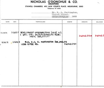
Legal record - Account, Nicholas O'Donohue & Co, Nicholas O'Donohue & Co to Partington 1971, 12/07/1971
A solicitor's account to Alan Partington following a land transaction with Development Underwriting Vic. P/L in 1971. Part of many land deals made by the Partington family in the sale of the original Greensborough farmland.Solicitor's account, black text on white paperalan partington, william alan partington, partington family, land deals greensborough, nullarbor -
 Greensborough Historical Society
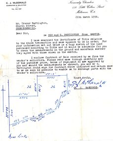
Legal record - Letter, C. J. McDonald, C.J. McDonald to Trevor Partington 1958, 26/03/1958
A solicitor's letter to Trevor [and Gary] Partington in preparation for a land transaction from vendor "Martin". The location of the land is not clear. It is possible that this land was purchased by Alan Partington in his adult children's names.Part of many land deals made by the Partington family in the sale of the original Greensborough farmland. Solicitor's letter, black text on white paperHand drawn plan of property.alan partington, william alan partington, partington family, land deals greensborough -
 Greensborough Historical Society
Folder, Investors in the Grace Park area - Fricker Brothers 1957, 2018_05
Collection of records regarding the acquisition of land by the Fricker brothers in the Grace Park area of Greensborough, and their sub-division and sale between 1957 and 1975. Researched and edited by Peter Simmenauer Folder containing Certificates of Title, photocopies of Death Certificate and Probate documents, list of land sales and historical notes, researched and edited by Peter Simmenauer grace park, fricker avenue greensborough, desmond court greensborough, desmond fricker -
 Greensborough Historical Society
Photograph, Keith Willimott, Willimott photographs, 1956-1964
... Street Watsonia. Includes sale advert for land (The Age 1956)... of Willimott home, High Street Watsonia. Includes sale advert for land ...8 photographs of construction of Willimott home, High Street Watsonia. Includes sale advert for land (The Age 1956)Photographs to accompany Willimott family oral history.Copy of group of black and white photographs. Copy of one newspaper advertisement for a block of land. 3 pages.Captions on back of each photograph.willimott family, watsonia, oral history -
Glenelg Shire Council Cultural Collection
Administrative record - Deed of Sale, 1853
hurd street portland -
 Greensborough Historical Society
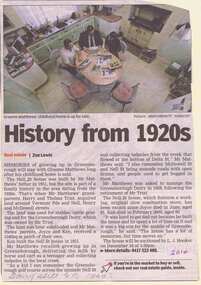
Newspaper clipping, Diamond Valley Leader, History from 1920's, 1920o
Then article is about the sale of the Matthews family house in Nell Street Greensborough. This house was built on the Trist Greensborough Dairy land which extended from Nell Street to Vermont Parade and McDowell Street. The house was built in 1951 by Ken Matthews.An article from the Diamond Valley Leader 2010c with a multi coloured photograph.Some pencil notes at the bottom and a date in purple biro.greensborough dairy, matthews family, trist, nell street -
 Greensborough Historical Society
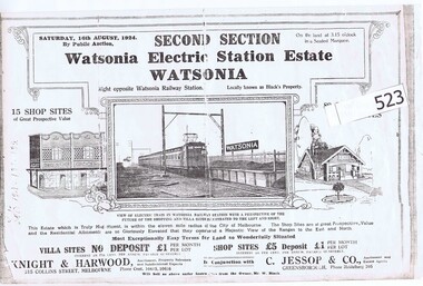
Advertising Leaflet, Knight & Harwood, Electric Station Estate, Second Section, Watsonia, 16/08/1924
Photocopy of auction leaflet for sale of second section of land north of Watsonia Railway Station, Saturday 16th August 1924. Auctioneer Knight & Harwood in conjunction with C. Jessop.Photocopy of auction leaflet 1 p.watsonia, watsonia electric station estate -
 Greensborough Historical Society
Folder of documents, Black Family in Greensborough and Watsonia, 1924o
Collection of copies of documents and plans relating to land owned by the Black Family in Greensborough and Watsonia, and its sale by auction and subdivision to form the suburb of Watsonia following the building of Watsonia Railway Station in 1924History of the development of the suburb of WatsoniaLoose-leaf folder, pages in file protectorsblack family, watsonia -
 Greensborough Historical Society
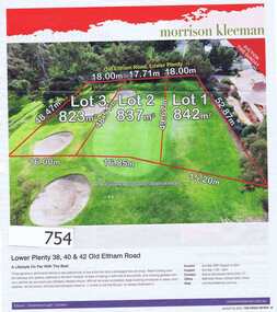
Advertisement, Fairfax Media, Lower Plenty 38, 40 & 42 Old Eltham Road, 22/08/2012
This advert appear in the Weekly Review on 22/08/2012.It features the sale of 38, 40 & 42 Old Eltham Rd, Lower Plenty in 2012. Land borders Heidelberg Golf Club.A 1 page multi coloured Real Estate advertisement.Nillower plenty, morrison kleeman, old eltham road -
 Greensborough Historical Society
Advertising Leaflet, Knight & Harwood, Electric Station Estate, Second Section, Watsonia, 16/08/1924
Auction leaflet (copy) for sale of second section of land north of Watsonia Railway Station, Saturday 16th August 1924. Auctioneer Knight & Harwood in conjunction with C. Jessop.Photocopy of auction leaflet 1 p.watsonia railway station estate, watsonia -
 City of Moorabbin Historical Society (Operating the Box Cottage Museum)
Document,photocopy plan 'Two Acre Village 'c1852, c1960
In the 1852 Josiah Holloway, a developer, purchased 625 acres from the squatters Richard and John King and sectioned '2 acre allotments' south of Henry Dendy's Brighton Survey along the Arthur's Seat Road ( later Nepean Highway) for sale @ £10 It became known as The Two Acre Village as settlers took up the allotments and established market gardens, general stores, butchers, blacksmiths, post office and 2 hotels. Charles Whorral opened The Cheltenham Inn and it became so popular as a meeting place that the area was called Cheltenham. The early settlers, who were predominantly English and Scottish immigrants initially leased their allotments and, because the sandy soil was so fertile, they were soon able to purchase the land and increase their acreage. Cheltenham became a very important part of the large Moorabbin Shire1871 and City of Moorabbin 1934 In the 1994 Amalgamation of Councils, when the large City of Moorabbin was divided between the newly formed Glen Eira, Kingston and Bayside Councils, the Cheltenham area was assigned to the City of Kingston A photocopy of the Plan for the 2 Acre Village in Moorabbin Parish c1852. A3 laminatedmoorabbin, brighton, cheltenham, market gardeners, pioneers, early settlers, , king. john, holloway josiah, whorral charles, arthur’s seat road, nepean highway , cheltenham inn hotel, henry dendy special survey 1841 -
 City of Moorabbin Historical Society (Operating the Box Cottage Museum)
Document, laminated List of Pioneers Moorabbin Parish, c1985
This list shows the names of the Pioneer settlers with the amount of Acres, the date purchased from The Crown and the Lot or Portion Number in the Land of the Henry Dendy Special Survey of Brighton 1841, in the County of Bourke , Victoria. The Squatters ,who arrived in the area first, used the land for grazing sheep and cattle. The Squatters had the right to graze unoccupied Crown land for ₤10 per year rental and a per capita payment for animals grazed. They could develop , improve and clear the land for the purpose of the tenancy but ownership was not permitted. When the land became useful The Crown put it on the market and the developers took over whilst the Squatters lost the improved land, dwellings and out buildings, there being no compensation paid. Squatters named John and Thomas Martin 1840-41; Richard and John King 1840- 1854 ; M.N.M.Moysey and M.J.Bickford 1841-1852 ; James McMahon 1846-1853 ; Daniel MacKinnon 1839- 1840. The 5120 Acres of the Henry Dendy Special Survey 1841were divided into approx. 83 Portions / Lots with varying acreage . Josiah Holloway, a speculator purchased 625 acres of the King Brothers run and re-sectioned the land into 2 acre Lots for Sale as market gardens. It was called The Two Acre Village later known as Cheltenham. A List of the names of The Pioneers in County of Burke Victoria c1841-1887 compiled by Lesley A. Schumer in 1985 A 3 Laminated display on wall in room 2 THE PIONEERS, Signed L.A. Schumer moorabbin, brighton, cheltenham, bentleigh, market gardeners, pioneers, early settlers, dendy henry, henry dendy's special survey 1841, squatters, king john, martin john, mcmahon james, two acre village, holloway josiah, were jonathan binn, grazing, cattle, sheep, market gardens, -
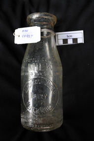 City of Moorabbin Historical Society (Operating the Box Cottage Museum)
Manufactured Glass, milk bottle 'Black Rock Dairy', 20thC
Alfred R Varcoe was a dairyman with stables, cart shed and his house in Eliza Street, Black Rock, Victoria. Dairy farming was established early in the settlement of the Brighton / Moorabbin area following the Dendy's Special Survey 1841 and subsequent land sales c1850. The produce was taken to feed the population of Melbourne and local residents.A clear glass ,1 pint , milk bottle used by Black Rock Dairy, MelbourneTHIS BOTTLE CONTAINS/ MILK / BOTTLED FOR SALE BY / BLACK ROCK MODEL / DAIRY / BLACK ROCK / BOTTLE IS THE PROPERTY OF THE ABOVE / IT IS OWNED AND CANNOT BE LEGALLY USED BY OTHERS/ ONE IMPERIAL PINT on base 440market gardeners, early settlers, farmers, dairies, milk production, moorabbin shire, moorabbin, cheltenham, black rock, brighton, dairy farmers, bottles, glass manufacture, varcoe alfred r; black rock dairy, dairy farmer, dairy products sales and deliveries, -
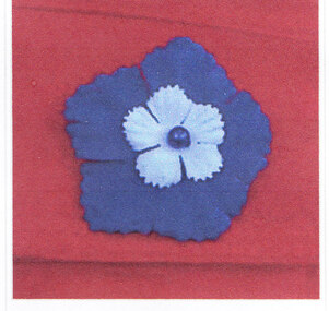 Geelong RSL Sub Branch
Cornflower - Bleuet de France, Early 20th Century
The bleuet de France is the symbol used in France to finance War Veterans, very similar the the Poppy. The bleuet de France is available for sale on 11 November and 08 May each year. Similar to the poppy this flower continued to grow in land devastated by shelling and military activity.This pin is an original.A Blue metal flower (cornflower) on a metal lapel pin.bleuet de france, poppy like flower -
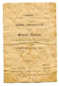 Orbost & District Historical Society
advertisement, 1902
Mrs Arthurena Dora Beattie (nee Morrison), had been teaching privately at Rosedale and came to Orbost with her husband and family in 1890. In 1892 she opened a private school in Salisbury Street (about the site of the Countryman Motor Inn) which she conducted for about 10 to 12 years. Her husband, John Wilson Beattie, a retired State School teacher, had been head teacher at the Rosedale School from July 1870 to August 1884. After coming to Orbost he selected land on Wall Creek. He was a widower with 7 of 11 surviving children when he married Arthurena in 1885. His fist wife, Georgina (nee KELLY) died at Rosedale in 1883 when the youngest child was just 5 weeks old. John and Arthurena had a further 8 children (5 born at Orbost), and after John's death she married George McCARLIE in 1916 at Sale and moved Mirboo North. (references:BEATTIE, Arthurena Dora Music teacher, Orbost - 1903 Electoral Roll. BEATTIE, Arthurena Dora Teacher, Orbost - 1912 Electoral Roll.) There was at least one other private school much earlier, in 1884. It was thought to be the first school in the district and conducted by William Ballantyne. It was located on the flat on the Newmerella side of the Snowy River near where the first railway crossing used to be. Wm Ballantyne had previously taught school at Sarsfield from June 1873 to November 1879. (information from John Phillips) This advertisement was for educational tuition by Mrs Beattie. Tuition would be from 10.00am - 12.00 and from 1.30pm - 3.30pm. Costs were thirteen shillings per quarter for children under the age of 12 years and one guinea for those over 12 years. A reduction would be given for more than one child in the same family. The 1872 legislation required all children aged 6-15 years to attend school unless they had a reasonable excuse. Parents who did not send their children to school were liable for fines up to five shillings for a first offence, with the penalty increasing to 20 shillings for each repeat offence. The Orbost State School had opened on 19th of March 1886 and this "private school" appears to have been a small private enterprise school. This is a useful research item associated with education in Orbost.A white A5 size paper advertisement which has black print. It is an advertisement for private educational tuition. Details of costs and hours are included.beattie education school advertising -
Ringwood and District Historical Society
Commercial papers, Aird, J.G, Papers re Land Purchases and transfers between J.G.Aird and others 1919-1924, 1919-1924
Details of monies paid to J.G. Aird and handled by him in connection with the sale of lands.2 bundles of papers pertaining to the collection of monies involved in land purchases and transfers between Mr. J.G. Aird and other parties stapled together in brown folder. +Additional Keywords: Aird, J.G. -
 Ringwood and District Historical Society
Flyer, Flyer advertising auction sale of ex service station site in Ringwood, Victoria - 1974
Single page advertisement for auction sale of restricted business site, corner of Whitehorse Road and Wantirna Road, Ringwood, Victoria, on Wednesday, 9th April (1974).Advertisement includes location map and terms of sale of 3 separate certificates of title on land zoned as Restricted Business (Not to be used for any petroleum product business). Sole Agents - K.J. Mulhall Pty. Ltd., 358 Lonsdale Street, Melbourne (Telephone) 67 8338, A.H. 91 1511. Auctioneer - Allan Lord. Handwritten notation describes this as originally the site of Ibbotson's Hay and Corn Store. -
 Ringwood and District Historical Society
Flyer, Advertisement for land auction - Pine Lodge Subdivision, Ringwood East / Croydon, Victoria - 1983
Folded A3 double sided page advertising auction of 14 timbered allotments - 3/4 to 4 acres, on Saturday, 10th December, 1983, with terms of sale, location map, and summary of subdivision features.Subdivision includes Angus Avenue, Vasey Concourse and Ruthven Way, Ringwood East, and Cheong Street, Croydon, Victoria. A covenant has been placed on most titles specifying that only one dwelling house can be erected during the next ten years. Auctioneers in Conjunction - Stockdale & Leggo, 422 Collins Street, Melbourne, (Telephone) 67 6661, A.H. 20 2364, and C.E. Carter & Son, 122 Whitehorse Road, Ringwood, Victoria 3134, (Telephone) 870 6211, A.H. 876 4124. -
 Ringwood and District Historical Society
Letter, Property for sale - Ringwood Shop and Dwelling Estate, Ringwood, Victoria - circa 1925
ID 5225 note: Further information relating to allotments marked on the hand-drawn plan are included in ID 5224 - Ringwood Station Estate.Typewritten letter from A.V. Greenwood with hand drawn plan of Ringwood Shop and Dwelling Estate, detailed description of property for sale, and top and side elevation views of house. (7 pages)(Transcript of first page - to unknown recipient) Phone 988 Central, 331 Canty Greenwood Pty. Ltd. 5 Flinders Street Melbourne. Dear Sir, 1. Attached please find drawings of my house at Ringwood. 2. It is for sale at £4,865 or to let at £5 per week to an approved tenant. 3. I sold it to Mr. De Garis and vacated it, but it is now back on my hands. 4. I leased another place instead of living in my own. I may be able to cancel same; in the meantime, however, I propose to sell or let my own. The painters are now going through the place; re-varnishing, re-oiling and re-polishing so that in about five days it will look "spick and span". 5. The house was specially built under my own supervision. 6. It is very suitable for a high class Guest House, Doctor's residence, Hospital or Convalescent Home. If you know of anyone whom it might suit, please communicate with them. DESCRIPTION 7. It stands on 305 feet of land facing Greenwood Avenue. It is cement, roughcast and hardwood, well oiled, and is now being redone so that the house is as good as new; red tile roof; verandahs three sides; two sleep-outs; five bedrooms; large dining room; very large music room with nooks, upstairs lounge, study; sewing room; built-in wardrobes and cupboards throughout; handsome kitchen with handsome pantry cupboard with drawers and glass front; one bath room; one shower room; wash house with patent copper and laundry. Every modern convenience, hot water system (through copper pipes with large copper cylinder) electric lights everywhere, outside and in, Yan Yean water laid on everwhere throughout house and gardens. Floors throughout are the very best, close set, stained and polished; dainty lead light windows etc. 8. There is a big garage, with tiled roof and two rooms with all conveniences for a married couple. Property is well drained with a system of its own. The house stands upon the top of a hill close to Railway Station, say 500 feet from the Footbridge. 9. The garden has expansive shrubs; sheds; fernery; tennis court. 10. A handsome piece of furniture goes with the house; a combination pantry and storeroom for groceries, milk, bread etc., consisting of drawers, glass and wire doors, as mentioned above. 11. It is within easy distance of Melbourne as it is only two minutes from Ringwood Station, which is a frequent electric train service bringing it within 39 minutes of the City. It is thought better by some to go further out into the country atmosphere and walk a short distance at the end than to go by train 20 minutes then walk 15 to 20 minutes. 12. The price quoted of £4,865 is made up as follows - 305 feet of land @ £5 ... £1,515 Garage and dwelling ... £300 House hot water system, American cupboard ... £2,600 Water, fencing, sheds & drain ... £250 For the lot ... £4,865 Should you require copies of the enclosed drawings I shall be pleased to supply same. 13. Mr. J.B. McAlpin is the local agent, Phone Ring. 7 (after hours Ring. 44) or you may phone me Central 988. 14. The house is south of the line, facing Greenwood Avenue and immediately at the back of Ringwood House, which is also my property. Yours sincerely, A.V. Greenwood (illegible) ..... (Transcript of second page) RINGWOOD SHOP AND DWELLING ESTATE See these letters on plan attached (H.) Ringwood House and Shops on 100 by 150 feet of land fronting Bedford Road 100 feet @ £10 per foot - £1,000 House and shops - £2,400 ... £3,400 Ringwood House consists of Boarding House, (Phone 101) and two shops, mainly brick; 9 inch walls. Will carry another story. Has music room, dining room, entrance halls, 10 bedrooms, large verandahs, all conveniences, hot and cold water, and stands on what will become a most valuable business corner. (F.)(G.) Mr. Greenwood's house, garage and sheds, stands on 307 feet of land fronting Greenwood Avenue. See detailed description attached ... £4,865 (J.) Cottage on Block 81 in William Street ... £750 (K.) Cottage in Pitt Street ... £650 (Total) £9,665 ..... (Description of third page - Subdivision Plan) Drawn by Edyth Greenwood, phone 988 Central. Subdivision includes Station Street, Pitt Street, Bedford Road, Wantirna Road, James Street, William Street (later Kendall Street), Greenwood Avenue, Ellison Street, and Haig Street. Circles denote blocks for sale. Squares denote house properties for sale. Other features marked include location of businesses along Main Street (Maroondah Highway), cool store, railway station, shop and police station on Bedford Road, church on Station Street, site of schoolmaster's residence and State School, and location of proposed public baths -
 Ringwood and District Historical Society
Flyer, Auction Sale Brochure - Adjoining Weatherboard Villas, Albert Street and Thanet Street, Ringwood - circa 1921
Single page advertisement with black and white photographs of two adjoining timber villas fronting Albert Street and Thanet Street, Ringwood for auction on Saturday, 7th May (1921?).Under instructions from E.W. Smail, esq., Public Accountant, 31 Queen Street, Melbourne. Two well constructed timer villas, each containing 5 rooms, electric light, bath and laundry, good position, land to each 66ft x 258 ft., made road. These well-built homes, so nicely situated in this charming district, only 6 minuts to Ringwood Station, Churhes, Shops, etc., are for positive sale, and are specially suitable for homes and in estments. Terms at sale. J.C. Adams & Son, Auctioneer, 364 Burke Road, Camberwell. J.B. McAlpin, Ringwood, Local Agent. -
 Ringwood and District Historical Society
Flyer, Stillwell & Stephens Pty. Ltd, Brochure - Multiple Properties for Public Auction at Box Hill, Ringwood, Wonga Park and Clarinda - 28th November, 1934
Seven-page brochure advertising Mortgagees' Realising Sale by Public Auction on Wednesday, 28th November, 1934 for properties at Box Hill, Ringwood, Wonga Park, and Clarinda (via Oakleigh), including photographs, property descriptions, and terms of sale.Auction Commencing at 2.15 p.m. in the Orient Line Auction Rooms, 352 Collins Street, Melbourne. Solicitors: Messrs. Madden, Butler, Elder & Graham, 406 Collins Street, Melbourne. (Agents) H.P. Knight & Co. Property Salesmen and Subidivisional Experts, 315 Collins Street, Melbourne, 'Phones: Central 10615, 10616. Attractive Residential, Orchard, and Market Garden Properties, and Public Hall and School Rooms. 1. Wonga Park via Ringwood - "Holme Bush" off Warrandyte Road, Part of Lots 14 and 15, Ringwood Orchard Estate, approximatgely three miles (north) of Ringwood Railway Station - 64 Acres. 2. 17 Bishop Street, Box Hill - timber residence. 3. Greenwood Avenue, Ringwood - On East Side, 150 feet 3 inches South of Bedford Road - timber attic residence. 4. Ringwood - Wantirna Road, South-east corner of Canterbury Road - Orchard Property of approx. 11-1/2 Acres. 5. Box Hill - Whitehorse Road, South-east corner of Linsley Street - Timber building utilised as a Public Hall and Private School. 6. Clarinda vic Oakleigh, Talbot Crescent, off Centre Road - Home on 10 acres of land.