Showing 1181 items matching "municipality"
-
 Greensborough Historical Society
Map, Melbourne and Metropolitan Board of Works. Survey Division, MMBW, Yarra 2500 / 12.21. Watsonia North, 1979_02
Melbourne and Metropolitan Board of Works. Yarra 2500 [base map]. 12-22, Parish of Keelbundora 2856, Municipality of Diamond Valley 257. Shows street names, easement sizes, lot numbers, lodged plan numbers, names of prominent features, contour values, creek or river names. Watsonia Railway Station and environs. Prominent streets: Grimshaw Street, William Street and Macorna Street. Includes former Institute of Social Welfare (now Loyola College) Lines Reserve and Binnak Park.MMBW Map in 1:2500 [scale] series. Cream parchment with green tape reinforcing on edges and punched holes on left edge.mmbw, melbourne and metropolitan board of works, shire of diamond valley, watsonia - maps, bundoora - maps -
 Uniting Church Archives - Synod of Victoria
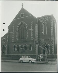
Photograph, undated
The Gipps Street Wesleyan Methodist Church of 1874 and the adjoining school hall, were built in the Collingwood Flat area - one of the municipality's poorest areas. In 1903, the Collingwood Methodist Mission was established with its headquarters in the Gipps Street Church. Six Methodist Missions were created in inner Melbourne. Three churches were operated by the Collingwood Mission. They were: Sackville Street Collingwood, Elizabeth Street, North Richmond (demolished), and Gipps Street Collingwood (demolished). The Mission operated until approximately 1930.B & W exterior view of the Gipps St. Collingwood Methodist Church. The image is a street view of a group of children and an adult standing in front of the brick church.gipps st. methodist church, les gorrie, collingwood mission -
 Otway Districts Historical Society
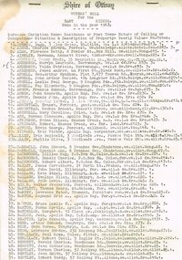
Voters, Shire of Otway, Shire of Otway, Voters' Rolls, 1963, 23 July 1963
After going to a Revision Court where the voters' rolls had been revised and certified correct every voter on the Shire of Otway register was listed with his or her surname, christian names, residence or post town, nature of calling or occupation, situation and description of property, the yearly value, and the number of votes to which the incumbent was entitled. It included both local residents and residents from other municipalities who owned allotments in the Shire of Otway entitled to vote in Shire of Otway elections.Typescript. Shire of Otway, Voters' Roll for the East (a), Central (b), West (c) and Apollo Bay [comprising a portion of the Parish of Krambruk] (d) Ridings, made in the year 1963. Certified for each riding that it "has been revised and is correct", signed by W.H. Tann, Chairman of Revision Court, 23rd July, 1963.Variously underlined, marked, and written on the verso.shire; otway; voter roll; -
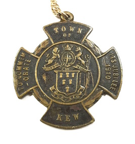
 Kew Historical Society Inc
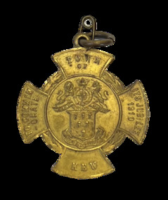
Medal, Town of Kew : To Commemorate its Jubilee, 1910
Medal issued to commemorate the 50th jubilee of the Town of Kew. It names J.F. McCrea as Mayor. John Falding McCrea was Mayor of Kew 1910-11. Kew was proclaimed a municipality on 22 December 1860, seceding from the Boroondara Road Board District, then comprising Kew, Hawthorn and Camberwell. It was proclaimed a town on 8 December 1910, the year this medal was issued, and a city on 10 March 1921. On 22 June 1994 Kew city was united with Camberwell and Hawthorn cities to form Boroondara city. (MV)Gilt bronze Town of Kew Jubilee medal in the shape of a Maltese Cross.Obverse description Shield of six wheat-sheafs above motto CRESCO on ribbon; above shield is the Royal coat of arms with lion and unicorn supporters and, on ribbon DIEU ET MIN DROIT; on arms of cross top, TOWN / OF, bottom, KEW, left TO COMMEM / -ORATE, right, ITS JUBILEE / 1910 Reverse description shield of six wheat-sheafs above motto CRESCO on ribbon; above shield is the Royal coat of arms with lion and unicorn supporters and, on ribbon DIEU ET MIN DROIT; on arms of cross top, TOWN / OF, bottom, KEW, left TO COMMEM / -ORATE, right, ITS JUBILEE / 1910town of kew jubilee (1910), commemorative medals - kew (vic), australian commemorative medals -
 Kew Historical Society Inc
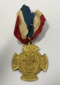
Medal, Stokes & Sons, Town of Kew : To Commemorate its Jubilee, 1910
Medal issued to commemorate the 50th jubilee of the Town of Kew. It names J.F. McCrea as Mayor. John Falding McCrea was Mayor of Kew 1910-11. Kew was proclaimed a municipality on 22 December 1860, seceding from the Boroondara Road Board District, then comprising Kew, Hawthorn and Camberwell. It was proclaimed a town on 8 December 1910, the year this medal was issued, and a city on 10 March 1921. On 22 June 1994 Kew city was united with Camberwell and Hawthorn cities to form Boroondara city.Mint gilt medal with original ribbon.Kew Jubilee medal in the shape of a Maltese cross. Gilded bronze with attached original red, white and blue cloth ribbon. On the front is the Coat of Arms of the Town of Kew and an inscription: ‘Town of Kew. To Commemorate Its Jubilee 1910’. On the reverse is inscribed 'Kew Jubilee 1860-1910. Cr J.F. McCrae J.P. Mayor'. The medal was also issued in bronze.Obverse description Shield of six wheat-sheafs above motto CRESCO on ribbon; above shield is the Royal coat of arms with lion and unicorn supporters and, on ribbon DIEU ET MIN DROIT; on arms of cross top, TOWN / OF, bottom, KEW, left TO COMMEM / -ORATE, right, ITS JUBILEE / 1910 Reverse description Within line circle set at centre of cross shaped flan, CR. J.F. McCREA / J.P. / MAYOR on arms of cross, top, KEW bottom, JUBILEE, left 1860, right, 1910jubilee - kew (vic), commemorative medals - kew (vic), australian commemorative medals -
 Kew Historical Society Inc
Medal, Stokes & Sons, Town of Kew : To Commemorate its Jubilee, 1910
Medal issued to commemorate the 50th jubilee of the Town of Kew. It names J.F. McCrea as Mayor. John Falding McCrea was Mayor of Kew 1910-11. Kew was proclaimed a municipality on 22 December 1860, seceding from the Boroondara Road Board District, then comprising Kew, Hawthorn and Camberwell. It was proclaimed a town on 8 December 1910, the year this medal was issued, and a city on 10 March 1921. On 22 June 1994 Kew city was united with Camberwell and Hawthorn cities to form Boroondara city. (MV)This work forms part of the collection assembled by the historian Dorothy Rogers, that was donated to the Kew Historical Society by her son John Rogers in 2015. The manuscripts, photographs, maps, and documents were sourced by her from both family and local collections or produced as references for her print publications. Many were directly used by Rogers in writing ‘Lovely Old Homes of Kew’ (1961) and 'A History of Kew' (1973), or the numerous articles on local history that she produced for suburban newspapers. Most of the photographs in the collection include detailed annotations in her hand. The Rogers Collection provides a comprehensive insight into the working habits of a historian in the 1960s and 1970s. Together it forms the largest privately-donated collection within the archives of the Kew Historical Society.Bronze Town of Kew Jubilee medal in the shape of a Maltese Cross.Obverse description Shield of six wheat-sheafs above motto CRESCO on ribbon; above shield is the Royal coat of arms with lion and unicorn supporters and, on ribbon DIEU ET MIN DROIT; on arms of cross top, TOWN / OF, bottom, KEW, left TO COMMEM / -ORATE, right, ITS JUBILEE / 1910 Reverse description shield of six wheat-sheafs above motto CRESCO on ribbon; above shield is the Royal coat of arms with lion and unicorn supporters and, on ribbon DIEU ET MIN DROIT; on arms of cross top, TOWN / OF, bottom, KEW, left TO COMMEM / -ORATE, right, ITS JUBILEE / 1910town of kew jubilee (1910), commemorative medals - kew (vic), australian commemorative medals -
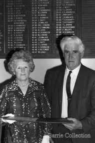 Melton City Libraries
Photograph, Councilor Tom and Mrs. May Barrie, Unknown
Tom Barrie served the community in the following Shire of Melton Councilor Member for 32 years 1941–1970 Elected as Councilor for Melton South 1970–1973 Councilor for Rockbank 1943–1944 Shire President for three terms 1958–1959 ditto 1964–1965 ditto Council Representative: Bacchus Marsh High School and Western Suburbs Municipalities. Representative on delegation to prevent Melton post primary students being sent to Deer Park prior to the establishment of Melton High SchoolPossibly being presented with Shire of Melton illuminated address at the Melton Shire Officeslocal identities, council -
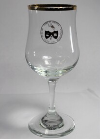 Wodonga & District Historical Society Inc
Memorabilia - Wine Glass Rural City of Wodonga, C. 1973 - 2000
Wodonga Shire was created in 1876 when the colonial government agreed to ratepayers' petitions to have their area severed from the Yackandandah Shire and form a new municipality. In 1973, the Wodonga Shire was granted rural city status and was officially named the Rural City of Wodonga by the Governor of Victoria, Sir Rohan Delacombe. In 1994, a new local government authority, the Wodonga Rural City Council was created. In December 2003, the council was again legally re-named to become Wodonga City Council.The glass is representative of memorabilia produced to celebrate the achievement of a special status in the development of local government in Wodonga. Wodonga had "Rural City" status from 1973 until 2003.A standard wine glass with a gold trim and bearing the logo of the Rural City of WodongaAround the edge of the logo "RURAL CITY OF WODONGA / FIDES ET JUSTITIA"wodonga, local government, rural city, souvenir wodonga -
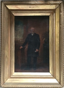 Kew Historical Society Inc
Painting - John Halfey, c.1882
John Halfey (1825-89) was born in Southport, Lancashire and migrated to Victoria in 1852. After finding gold at Sandhurst, and representing the latter in the Victorian Parliament, he moved to Melbourne to engage in various commercial pursuits, including directorships of insurance, mining and banking companies. A resident of Kew from the late 1850s, he was known for the hospitality provided at his house Ordsall (later Southesk) in Cotham Road. On 14 December 1860, Halfey chaired a public meeting calling for separation from the Boroondara Roads Board, which led, four days later, to the proclamation of Kew as a separate municipality. He was elected to the Council in 1861, replacing Cr. Oswin, and subsequently served as the second Chairman of the Municipality in 1862-1863. John Halfey became a trustee of Holy Trinity Church in Bulleen Road (now High Street) in 1862. He was to resign from Council after four years in 1865. Twenty-four years later in January 1889, he died aged 63 from a seizure, at his rooms at the Herald Office. He was interred in the Boroondara General Cemetery where his monument is the tallest in the Cemetery. Donated by Eileen Grigg, 2017Small, full-length portrait of John Halfey in an original gilded frame. The artist depicts him formally dressed in a frock coat beside an open window. He is shown holding a document or perhaps a pair of gloves. The painting is badly damaged with a hole in the area of his face that has been patched and repainted.john halfey, ordsall, chairman of kew, boroondara roads board, municipality of kew -
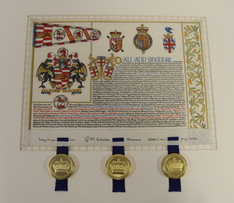 Glen Eira City Council History and Heritage Collection
Letters Patent, Letters Patent for the Grant of Arms to the City of Caulfield presented on 1st May, 1977, 01/05/1977
Glen Eira has a long history of association with various heraldic forms. From its early years the municipality of Caulfield had used the armorial bearings of the Caulfield Family (the Charlemonts of Castle Caulfield) to represent the roads board and later the town and city. In 1969 Caulfield City Council began planning to apply for an official coat of arms for the City. In 1974 Horace Hall, a Balwyn North resident and member of the Heraldry Society in London advised Council that the current usage was illegal, and that the Houston family, current owners of the Caulfield Arms could take legal action against Council for 'usurping their arms'. Mr Hall was commissioned to develop new heraldry for the City, and in conjunction with J. P. Brooke Little at the College of Arms, London, he prepared an acceptable design for Caulfield's Coat of Arms. The Council paid an additional sum to have a standard painted on the Letters Patent and the municipality's new coat of arms was drawn up in June 1975. The Coat of Arms retains a number of heraldic elements from the original Caulfield family insignia, including the dragons, the colours and the elements of the shield. The newly registered coat of arms and Letters Patent document for the granting of arms was presented at a civic service to mark the granting of armorial ensigns and the city banner to the City of Caulfield on the 1st May 1977. Significant elements of the coat of arms granted by these Letters Patent are as follows: The motto 'Labore Vinces' translates to 'By our labours we will conquer'. The helmet represents the rank of the owner. Public authorities are granted an esquire's helmet. The brickwork on the crest is a recognised emblem of local government. The Letters Patent also display a banner and a badge, both official symbols of the City of Caulfield. The badge, which is displayed on the banner as well as on its own, features a bridled horse. This represents the importance of racing, the Caulfield racecourse and the Caulfield cup to the municipality. These letters patent officially proclaim the granting of the coat of arms to the City of Caulfield. They are highly significant to the City of Glen Eira as they are the primary document that signifies the official and ceremonial heraldic powers of the Coat of Arms of the City of Caulfield. Mounted Letters Patent illuminated document for the Grant of Arms to the City of Caulfield presented on 1st May, 1977. Hand written and hand painted on cream coloured parchment using different coloured inks, mainly black, blue, red and gouache and gold paint. The bottom edge is folded up over itself approx. 45mm revealing the flesh side of the parchment, which displays black ink signatures and three sets of two horizontal slits that hold three blue ribbon. The ribbons support three wax seals in round, gold coloured metal cases held by the wax through slots in the casing. Although covered by the cap top, each wax seal within displays a different flag emblem with a crown on top, surrounded by a ring of text (difficult to read), noted when the cases were opened during conservation treatment. See attached transcription.arms, symbol, heraldry, glen eira, council, caulfield -
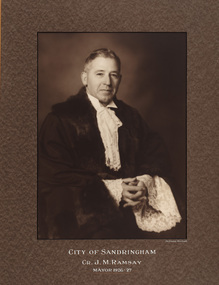 Bayside Gallery - Bayside City Council Art & Heritage Collection
Photograph - sepia photograph, Dickinson-Monteath Studio, Councillor J.M. Ramsay, Mayor of Sandringham 1926-27, c. 1936
James Morrison Ramsay (1882-1963) was Mayor of Sandringham in 1926-27. He was a candidate for the Brighton Seat in the legislative assembly in 1928.councillor, sandringham, local government, municipality, mayor, mayoral robes, portrait, city of sandringham, jabot, dickinson-monteath studio, james morrison ramsay, cr. j.m. ramsay, legislative assembly, brighton, mayor of sandringham -
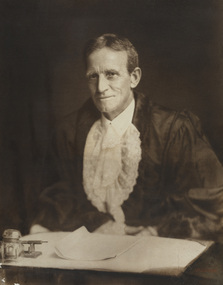 Bayside Gallery - Bayside City Council Art & Heritage Collection
Photograph - sepia photograph, Vandyck Studios, Councillor J.B. Wilson, Mayor of Brighton, 1929-30, c. 1930
James Brisbane Wilson (1865-1933) was a councillor at Berwick for 17 years, later a member of Cranbourne Council. He moved to Brighton in 1924 and was elected to council in the South Ward, becoming Mayor in 1929-30.councillor, brighton, local goverment, municipality, mayor, mayoral robes, jabot, portrait, cr. j.b. wilson, james brisbane wilson, south ward, bayside, berwick council, cranbourne council, mayor of brighton -
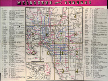
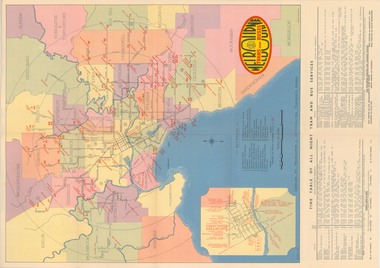 Melbourne Tram Museum
Map, Melbourne & Metropolitan Tramways Board (MMTB), "Map and timetable of Melbourne Tram and Bus Services" - March 1952", Mar. 1952
Fold out map (10 sections), coloured of Melbourne's Tram and Bus routes, route numbers, rail lines, municipalities boundaries and location of major places of interest. Titled - "Map and timetable of Melbourne Tram and Bus Services" - May 1952". At base of map - timetable of all night trams and bus services. On rear index to routes, 1st and last services, time of Sunday am services, Latrobe St. services and photo of Wattle Park. Dated March 1952 - Bourke St shown as bus. See Reg Item 413 for the May 1956 version. Very high resolution scans held. See also Reg Item 3720 for a MMTB Map of the same era.trams, tramways, melbourne, map, tram & bus services, all night services, mmtb -
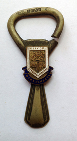 Warrnambool and District Historical Society Inc.
Souvenir - Souvenir Bottle opener, Mid 20th century
Warrnambool, established in 1847, became a Municipality in 1856, a Borough in 1863, a Town in 1883 and a City in 1918. This bottle opener has most probably been produced by the City of Warrnambool for promotional purposes and may have been given as gifts to notable visitors. The logo used is a version of the original ‘By These We Flourish’ seal which was first adopted by the Council in 1856. On the top portion is the Royal Coat of Arms. On the lower section is a sailing ship and a sheaf of wheat. The seal was designed by John Macdonald, a local schoolteacher and auctioneer. This bottle opener is of some interest as a promotional item produced for the Warrnambool City Council. It may be useful for display. This is a bottle opener made of electro-plated nickel silver. It has a badge with blue, white and gold enamelling with the old logo of the City of Warrnambool. The ring is broken – cut through at one end. ‘E.P.N.S.’ ‘City of Warrnambool’ ‘By These We Flourish’ city of warrnambool, bottle opener, souvenir household items, warrnambool souvenirs -
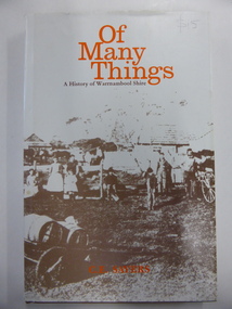 Warrnambool and District Historical Society Inc.
Book, Of Many Things, 1987
This book is the official history of the Shire of Warrnambool from 1863 to 1987. It was written by C.E. Sayers for the Shire of Warrnambool. Sayers also wrote the history of Warrnambool called By These We Flourish for the Warrnambool City Council. The Shire of Warrnambool was established in 1863 and the first meeting was held in January 1864. In 1992 the Shire covered an area of 1605 square kilometres and had a population of 8,940 and included the areas around Koroit, Allansford, Peterborough, Port Fairy and Nirranda. The Shire of Warrnambool was abolished in 1994 and was incorporated with other municipalities into the Shire of Moyne. This book is the official history of the Shire of Warrnambool and this copy is kept for future reference when the book is superseded or out of print. This is a hard cover book of 196 pages. It has a brown cover with gold lettering on the spine. The dust cover has a white background with an image on the front cover in brown and grey tonings of a rural property in the Shire of Warrnambool. The lettering on the dust cover is orange on the front cover and black on the spine. The book has a foreword, an introduction, 14 chapters of text, appendices and an index. There are many black and white photographs.shire of warrnambool, history of warrnambool, of many things -
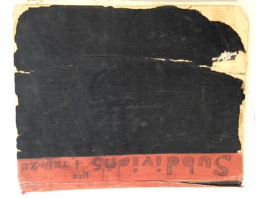 Warrnambool and District Historical Society Inc.
Book, Subdivision No 1 to 1420, 1930s
This is an exercise book listing subdivisions in Warrnambool from 1935 to 1977. There are 1420 entries. It gives details of the subdivisions – plan number, street, section number, allotment number, date, owner, solicitor and Titles Office number. The book is completely filled and today this information would be held in the Warrnambool City Council offices per electronic data storage. Warrnambool, founded in 1847, became a Municipality in 1856, a Borough in 1863, a Town in 1883 and a City in 1918. Subdivisions of land in the city continue to be made regularly for housing and business purposes.This book is of great historic interest because it details the subdivisions in the City of Warrnambool from 1935 to 1977. It shows the continuing growth of the city, particularly after World War Two. It will be a very useful resource for researchers. This is an exercise book with a black cardboard cover and red binding. It contains a list of City of Warrnambool subdivisions from 1935 to 1977. The cover and some of the pages are torn and ragged and the binding has come apart and has been glued together in places. The pages are ruled with blue and red lines. The pages contain handwritten material in black and blue ink. Front Cover: ‘Subdivions(sic), Nos 1 to 1420’ Inside Front Cover: ‘City of Warrnambool Subdivisions’ warrnambool city council, warrnambool subdivisions -
 Glen Eira Historical Society
Document - Caulfield Fire Station, No 26, Tree Reserve, Dandenong Road
A three page photocopy of a handwritten memorandum of agreement dated 11/10/1894 between the municipalities of Caulfield and Malvern and the Metropolitan Fire Brigades Board consenting to the erection of a fire station on Tree Reserve. Also a three page photocopy of a handwritten agreement dated 11/10/1894 between owners of properties in the neighbourhood of the junction of Dandenong Road and Waverly Road and the Metropolitan Fire Bridgades Board to allow the Board to erect and use a fire station on Tree Reserve in Dandenong Road. The agreement was signed by the property owners.caulfield east, shire of caulfield, tree reserve, caulfield fire station, rs anderson and son, fire stations, legal documents, lloyd c d, jowett f, delves catherine , catani c, federal building society, st james building society, nathan philip, trustees of the late john nathan, adams j, bates j -
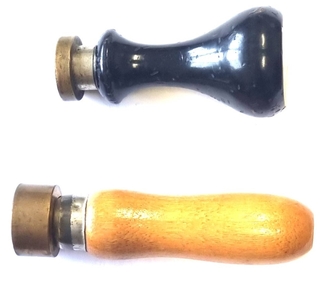
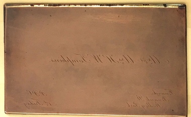 Kew Historical Society Inc
Functional object - Gravure Printing Plate for Mr & Mrs HW Tompkins
Henry (Harry) William Tompkins was a renowned Melbourne architect, former City of Kew councillor and sometime Mayor of the municipality. He was president of the Melbourne Institute of Architects in 1914-15. In partnership with his brother, Frank Beauchamp Tompkins, he designed the Myer Stores in Bourke and Lonsdale Streets in 1933. Locally he was the architect of the Kew War Memorial (opened 1925). At the time that the gravure plate was made, the couple lived in 'Fenwick', a house on the corner of Stawell Street and Fenwick Street, Kew, which has since been demolished.Copper (on steel?) gravure printing plate made for Mr & Mrs Harold Tompkins, 'Fenwick', Fenwick Street, Kew. Engraved in reverse script. It is assumed that the acronym PPC may stand for 'Please Present Card'. "Mr & Mrs H.W. Tompkins, Fenwick, Fenwick Street, Studley Park / PPC 1st Friday"harry tompkins, gravure printing plates, business cards -
 Melbourne Tram Museum
Map, Victorian Railways (VR), "Melbourne and Suburbs", 1956
Map printed by the Victorian Railways in 1955 gives places of interest, some facts about Melbourne, and amusements, with the map showing rail, tram, and railway bus routes, suburbs, golf links, sporting grounds, and municipalities. The Bourke St tram route to East Preston is shown but not the Nicholson St East Brunswick line which opened during mid 1956. Provides a detailed list of suburbs, miles from the GPO, and how reached from where. Notes it was published in Jan. 1956 by the VR Public Relations and Betterment Board.Demonstrates a Victorian Railways printed map of MelbourneMap - 8 fold printed in colourmaps, melbourne, tramways, bus routes, railways -
 Wodonga & District Historical Society Inc
Functional object - Wodonga Council Official Seals
Wodonga Shire was created in 1876 when the colonial government agreed to ratepayers' petitions to have their part of the local government district severed from the Yackandandah Shire to form a new municipality. In March 1973 Wodonga was declared as the first Rural City in Australia. This was officially proclaimed by the Governor of Victoria, Sir Rohan Delacombe at an open-air ceremony in Hovell Street following a procession along High Street led by the Victorian Police Band. The first meeting of the Council was held in the open air immediately after the Proclamation.These Seals are significant because they document different stages in the development of local government in Wodonga.Two wood and metal seals to endorse documents. The seal with black painted handle is for the Rural City of Wodonga. The brown handled seal is for the Shire of WodongaSeal 1 - Rural City of Wodongawodonga shire council, rural city of wodonga -
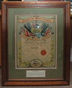 City of Whittlesea
Certificate - Illuminated Address - Corporal P E Cook, He Answered His Country's Call
Corporal Phillip Edward Cook, 4470, 46th Battalion AIF Over 300 men from the Shire of Whittlesea enlisted during WWI. One of these was Corporal Cook, son of the Rev. Richard and Elizabeth Cook, and husband of Jessie May Cook of Whittlesea. On 27 July 1915, at the age of 33, Phillip Cook enlisted in the AIF. He was killed in action at Bullecourt on 11 April 1917. Corporal Cook had no grave, but is remembered with honour at the Villers-Bretenneux Memorial, Somme, France.Illuminated address, framed - Record of Admiration and appreciation to Corporal PE Cook killed in action in 1917, during WWI. Produced by Shire of WhittleseaInscription: He Answered His Country's Call - The President, Councillors, and Ratepayers of the Shire of Whittlesea - Hereby place on record their Admiration and Appreciation of and thanks for the gallant conduct of - Corp. P. E. Cook - who served his King and Country in the Great War, which commenced 4th August, 1914 - In Witness Whereof the Corporate Seal of the Municipality - is hereto attached in the presence of - Leslie W. Clarke President - James Ryan Secretary - Dated 6. 12. 1918 -
 Greensborough Historical Society
Map, Melbourne and Metropolitan Board of Works. Survey Division, MMBW, Yarra 2500 / 12.22. Watsonia North, 1978_03
Melbourne and Metropolitan Board of Works. Yarra 2500 [base map]. 12-22, Parishes of Keelbundora 2856, Municipalities of Whittlesea 239 and Diamond Valley 257. Shows street names, easement sizes, lot numbers, lodged plan numbers, names of prominent features, contour values, creek or river names. Watsonia Railway Station and environs. Prominent streets: Edmund Rice Parade and Macorna Street. Includes Christian Brothers Edmund Rice College and Janefield Special School sites and "proposed future freeway" (now Metropolitan Ring Road).MMBW Map in 1:2500 [scale] series. Cream parchment with green tape reinforcing on edges and punched holes on left edge.mmbw, melbourne and metropolitan board of works, shire of diamond valley, watsonia - maps, bundoora - maps -
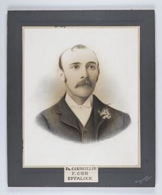 City of Greater Bendigo - Civic Collection
Photograph - Portrait of Councillor Orr, The Yeoman Studios, Ex. Councillor / F. Orr / Eppalock
The district of Strathfieldsaye was proclaimed in 1861 and named a Shire on the 17th September in 1866. It remained a shire until amalgamation in 1994 when it became part of the City of Greater Bendigo. The shire was located 8 km to the south- east of Bendigo and covered an area of 601 square kilometres and extended from the Calder Highway to the Coliban and Campaspe Rivers. The shire's administration centre was in Strathfieldsaye until 1972 when new offices were opened in Kennington. Eppalock Ward is one of three wards in the Greater Bendigo municipality which includes the former Strathfieldsaye Shire. Framed black and white head and shoulder portrait with hand coloured detail. Man with profile slightly to right, walrus moustache, image encircled. Photograph is attached to mount card. Hand written title lower centre.Ex. Councillor / F. Orr / Eppalock / The / Yeoman / Studiosshire of strathfieldsaye, councillor orr -
 Wodonga & District Historical Society Inc
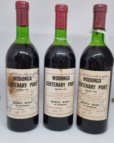
Memorabilia - Bottles - Wodonga Centenary Port, Morris Wines of Rutherglen, 1976
This bottling of Wodonga Centenary Port was provided by Morris Wines of Rutherglen to celebrate the Centenary of local government in Wodonga. Wodonga Shire was created in 1876 when the colonial government agreed to ratepayers' petitions to have their northern area severed from the Yackandandah Shire and form a new municipality. In 1976 celebrations were held to mark this milestone. These bottles were donated to the Wodonga & District Historical by Jenny Brown nee Terrill daughter of former Wodonga Shire President, Councillor J. A. Terrill. These bottles of the Wodonga Centenary Port were signed by all of the councillors serving in 1976.This artefact represents the celebrations for the centenary of local government in Wodonga.3 bottles of port produced by Morris Wines of Rutherglen. This bottling celebrated the centenary of local government in Wodonga. The label is on beige paper with a maroon outline and black text. These bottle have been autographed and bear the numbers 238. 248 and 343.On Label: "WODONGA / CENTENARY PORT/BOTTLED 1976/ THIS 1975 PORT WAS SPECIALLY/ SELECTED & BOTTLED TO CELEBRATE / ONE HUNDRED YEARS OF LOCAL GOVERNMENT IN WODONGA/ 10th MARCH 1876 - 1976/ MORRIS WINES / OF RUTHERGLEN/ PRODUCT OF AUSTRALIA NET 738 ml/ NO 343 E2314wodonga shire council, wodonga local government, wodonga local government centenary -
 Bendigo Historical Society Inc.
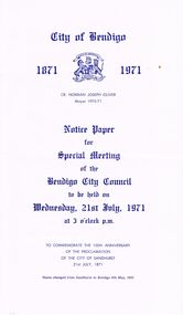
Document - BENDIGO CITY COUNCIL: NOTICE PAPER FOR SPECIAL MEETING 21/7/1971, 21st July 1971
(Seven paged) Notice Paper for Special Meeting (Bendigo City Council) 21/7/1971 to commemorate the 100th anniversary of the proclamation of the City of Sandhurst. Three copies (7702.a - 7702.c) Includes 'Council Summons'; list of Members of Council; Agenda for Special Meeting; photographic copy of extract from the Victoria Government Gazette (21/7/1871); reproduction photos of Town Hall, 1871, Cr J Boyd first Mayor and Cr. N Oliver , current Mayor; list of Chairmen of the Municipality (1855-1863), Mayors of the Borough (1863-1870-, Mayors of the City of Sandhurst (1871-1891), Mayors of the City of Bendigo (1891- 1971), List of Town Clerks (1856- 1971); (formal) Notice of Motion.Combridge Pressbendigo, council, council meeting, list of council members, mayor cr. j. boyd, cr. norman joseph. oliver, lyttleton terrace, mayor's of city of sandhurst. mayor's of city of bendigo. -
 Bendigo Historical Society Inc.
Document - CURNOW COLLECTION: INVITATION TO MR J. H. CURNOW, 24/04/1905
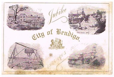
Invitation to Mr. J. H. Curnow to attend a dinner on the occasion of the first official visit of His Excellency Major-General The Hon. Sir Reginald Arthur James Talbot, K. C. B., Governor of Victoria and to celebrate the Jubilee of the Municipality on Monday, April 24th, 1905. On the front of the invitation, printed in gold is: Jubilee City of Bendigo 1855 -1905. Gold border 5mm from the edge. There are four scenes on the front, Pall Mall in 1855, Pall Mall in 1905, Mining in 1855 and South New Moon Mine 1905. On the inside is a scene of the Municipal Offices 1855 and the Town Hall 1905. On the right is the invitation. On the back cover is the City of Bendigo emblem and printed at the bottom is Town Hall, Bendigo, 1905 and A. Dunstan, Mayor.document, invitations, official celebrations, document, invitatioin to mr j h curnow, city of bendigo jubilee 1855 - 1905, south new moon mine, pall mall, municipa offices, town hall, j h curnow, his excellency major-general the hon. sir reginald arthur james talbot k c b governor of victoria -
 Ringwood and District Historical Society
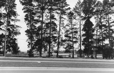
Photograph, Croydon West High School off Cutts Avenue and Maroondah Hwy, Ringwood - November, 1969
Written on backing sheet, "West Croydon School (In Ringwood municipality)". November 1969. The area behind the pine trees was used as a training ground by the Wilhelmina Soccer Club, later called Ringwood City SC and Ringwood FC. It was later sub-divided and the two streets named Wilhelmina and Juliana Courts, in honor of Wilhelmina, Queen of the Netherlands, and her daughter, Juliana, later succeeding her as Queen. The Burnt Bridge Shopping Centre can be seen in the far west on one of the images. -
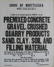 City of Whittlesea
Sign (item) - Shire of Whittlesea Notice, Reservoir Printing Works, Notice given to stop carting on roadway
Shire of Whittlesea / Notice is hereby given that as / is likely to be seriously injured by traffic - to wit / soil, clay, sand or stone carting / The Council of the Municipality of the Shire of Whittlesea has decided to / stop all carting on such roadway as from the - day of / - 196 - , to the - day of - 196 - , / both dates inclusive / Any person who contravenes or fails to observe the provisions of this / notice shall be liable to a penalty of not more than forty dollars ($40) / By order / R G C Cook, Shire Secretary / Reservoir Printing Workspublic notices -
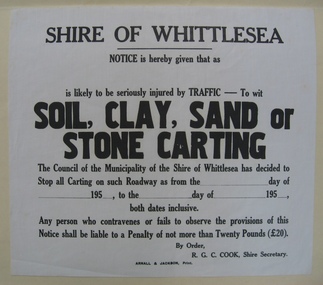 City of Whittlesea
Sign (item) - Shire of Whittlesea Notice, Notice given to stop carting on roadway - sand
Shire of Whittlesea / Notice is hereby given that as / is likely to be seriously injured by traffic - to wit / soil, clay, sand or stone carting / The Council of the Municipality of the Shire of Whittlesea has decided to / stop all carting on such roadway as from the - day of / - 195 - , to the - day of - 195 - , / both dates inclusive / Any person who contravenes or fails to observe the provisions of this / notice shall be liable to a penalty of not more than twenty pounds (20) / By order / R G C Cook, Shire Secretary / Arnall & Jackson, Printpublic notices -
 The Beechworth Burke Museum
Photograph - Photograph - Reproduction
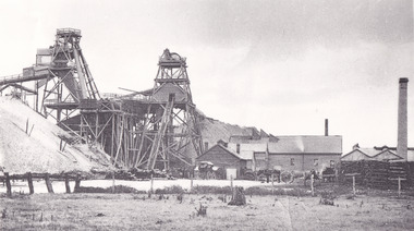
This photograph depicts the Great Southern Mine located in Rutherglen as it was during the 1900. After the initial Gold Rush of 1853-1854, Gold was discovered deeper under the surface of the earth in the 1860 after the discovery of another deep lead system. Due to the discovery of Gold in Rutherglen, Rutherglen developed into a community in its own right, possessing a population of 6600 by December 1860 and developed into a municipality in 1862. The Great Southern Mine depicted in this photograph required the use of a range of modern technologies, including the hydraulic pumps, in order to reach gold. This photo depicts the mining operations as they were undertaken around the turn of the century.The search for gold is ingrained into the history of Victoria and therefore, images like this one which portray a modern mining operation undertaken in the 1860s, can reveal important information for society and technology for the date when the photograph was taken. This image is of important historical significance for its ability to convey information about the methods used to extract gold in 1900. It is significant as most mining operations around the region, particularly earlier on in the period, used different technologies such as water races. This image is important for current research into the history of Rutherglen more generally, a town which developed singlehandedly due to the discovery of minerals and mining, as depicted here in this photograph, thus indicating an element of social significance as well as historic. The Beechworth Burke Museum has additional images relating to mining and Rutherglen which can be analysed and studied alongside images like this one.A black and white rectangular photograph printed on matte photographic paper.Reverse: $ 3.00 19972503 / a02503 / Great Southern Mine Rutherglen 1900rutherglen mine, rutherglen, great southern mine, beechworth, mine, mining, post goldrush, victoria, gold, 1860s, sluicing, hydrolic sluicing