Showing 1855 items
matching road reserve
-
 Eltham District Historical Society Inc
Photograph, Looking east across Main Road from just north of intersection with Diamond Street, Eltham, February 1968, Feb 1968
The watercourse passes under the road and railway at this point. Significant flash flooding occurred along this water course on Christmas Day 2011 causing significant damage to the railway line and road and flooding of Judge Book Village. In February 1968 an unknown person took a series of photos from the Eltham Hotel at Pitt Street heading north along Main Road through the shopping centre to just north of Elsa Court covering the length of the section of Main Road which was duplicated shortly thereafter. Shows the condition and environment of the streesscape of Main Road, Eltham immediately prior to the duplication between Pitt Street and Elsa Court through the shopping centre. Also shows a number of shops and businesses that operated at that time.Black and white photographduplication, eltham, main road, diamond street, bible street reserve, watercourse, drainage -
 Eltham District Historical Society Inc
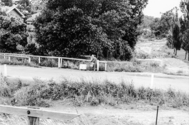
Photograph, Vacant land at 816 Heidelberg-Kinglake Road, Hurstbridge, c.1980, 1980c
Streetscape evolution; prior to development of reserve for housing units and redevelopment of shops opposite Hurstbridge Railway StationRoll of 35mm colour negative film, 4 stripsKodak GB 200 5096streets, heidelberg-kinglake road, hurstbridge, railway station -
 Eltham District Historical Society Inc
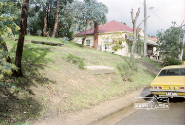
Photograph, Milk Bar at 808 and vacant land at 816 Heidelberg-Kinglake Road, Hurstbridge, c.1980, 1980c
Streetscape evolution; prior to development of reserve for housing units and redevelopment of shops opposite Hurstbridge Railway StationRoll of 35mm colour negative film, 4 stripsKodak GB 200 5096streets, heidelberg-kinglake road, hurstbridge, milk bar, bendigo bank, railway station -
 Eltham District Historical Society Inc
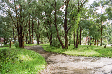
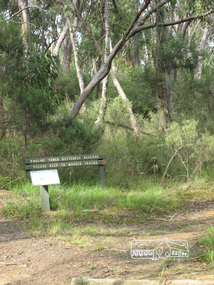
Photograph, Liz Pidgeon, Pauline Toner Butterfly Reserve, Eltham, 18 February 2011, 18 February 2011
... reserve eucalyptus road copper butterfly nature reserve walking ...Signage in the Pauline Toner Butterfly Reserve asking visitors to keep to marked tracks. The Reserve at the corner of Pitt Street and Eucalyptus Road, Eltham is managed by Parks Victoria. It is named for Pauline Toner M.P. who after the re-discovery of the rare Eltham copper Butterfly in large numbers in Eltham in 1987 worked to preserve its habitat.Born Digitalpauline toner reserve, eucalyptus road, copper butterfly, nature reserve, walking trail, sign, erosion -
 Eltham District Historical Society Inc
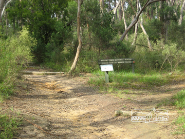
Photograph, Liz Pidgeon, Pauline Toner Butterfly Reserve, Eltham, 18 February 2011, 18 February 2011
... reserve eucalyptus road copper butterfly walking trail sign nature ...Signage in the Pauline Toner Butterfly Reserve asking visitors to keep to marked tracks. The Reserve at the corner of Pitt Street and Eucalyptus Road, Eltham is managed by Parks Victoria. It is named for Pauline Toner M.P. who after the re-discovery of the rare Eltham copper Butterfly in large numbers in Eltham in 1987 worked to preserve its habitat. Born Digitalpauline toner reserve, eucalyptus road, copper butterfly, walking trail, sign, nature reserve -
 Kiewa Valley Historical Society
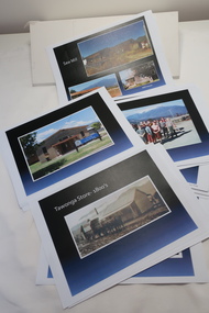
Coloured photographs on paper - Back to Tawonga 2010
These photos were collected and copied by Di Edmondson for the 'Back To Tawonga' Event in 2010 when she launched her book "Tawonga Remembers".An historical photographic collection of Tawonga and its surrounds, places and people up to 20101. Saw Mill - Mill house 2. The Rock Pool 3. People at the Rock Pool x 2 4.Old Saw mill 5. Back to Tawonga Celebrations x6 6. Tennis Curts opposite the Tawonga Store, Bakery in the background 7. Bowling Club 8. Old Guide Hall 9. The Old Boarding House 10. Old Fire Brigade Shed 11. Building the New Tawonga Memorial Hall 12. Tawonga Go Kart Track - 1960s 13. Tawonga Pony Club 1969 State Championships 14. Tawonga Recreation Reserve Newspaper article 15. The Damm Children 19. 1980s Brian Edmondson, Geoff Edmondson, Mick Harvey, David Piera. Geoff Edmondson's car 20. Tawonga Speedway Track - 1970s Mick Harvey and Paul Harkin's car 21. 2000 22. Tawonga Sports Vera Ryder and Allie Briggs 23. Tawonga School Photos x8 24. Harry Cooper's Farm Looking South 25.View from Edmondson's Farm - looking north 26. Mount Emu 27. St Aiden's Debutante Ball 27. Grand Opening Ball 1961 Tawonga Hall 28. The Kiewa Valley Road at Tawonga. Vic. 29. Tennis Courts opposite the Bogong Hotel 30.Opening of the new Toilet Block in Pioneer park 31. Old Tawonga Store x 3 32. Tawonga Memorial Hall 33. Anglican Church, St Aiden's x 2 34. Motor Khana held at Recreation reserve 35. 1970 State Champioships Team 36. Kiewa Valley School Sports at Dederang 37. Miscellaneous photos x27 Some photos have headings and some headings have been writtentawonga remembers, back to tawonga 2010, di edmondson -
 Eltham District Historical Society Inc
Photograph, Entrance to Shire of Eltham Memorial Park, Garden Hill, Eltham-Yarra Glen Road, Kangaroo Ground, c.1923
View to south-east from Shire of Eltham Soldiers' Memorial Park showing the carriageway from the road to top of Memorial Park. Accompanying notes state that the entry gate was put in place in May 1921. Eltham and Whittlesea Shire Advertiser and Diamond Creek Valley Advocate Fri 21 May 1920 p 2 reported: Kangaroo Ground Memorial Park "It was decided to arrange for a working bee on Saturday, 29th inst., for the purpose of forming and gravelling the track leading to the Park, and of carrying out other necessary works." A history summary of the Shire of Eltham Soldiers’ Memorial Park • The summit at Garden Hill was a popular tourist lookout and picnic spot from the 1880s. Virtually the entire Shire of Eltham and beyond could be viewed from this location. • A local farmer, Mr Walter A. D. Wippell is credited as being the first to propose the idea of a war memorial park and offered £50 towards the purchase of the land. • The earliest public reference to this project is to be found in the local Advertiser newspaper edition of August 9th, 1918. A report of the August Council meeting records the Eltham Shire President, Cr. Robert White, saying: "some time back it was proposed that the Council obtain and place on an Honour Board in the Council Chamber [at Kangaroo Ground] containing names of the lads who had enlisted. Just recently however, it had been suggested that a more fitting memorial would be the obtaining of a piece of land on the summit of Garden Hill, Kangaroo Ground, and the formation of a memorial park in which a monument could be erected to represent the whole of Shire. If a couple of acres could be obtained a gentleman had promised to donate 50 pounds, and another one would fence it, and other contributions, he was sure, could be obtained." • Councillors were favourable of the proposal and the President, Shire Secretary and Shire Engineer were deputised to wait on Messrs Mess Bros. (the owners of the Garden Hill farm) and ascertain if they would gratuitously give the land. The Mess Bros. land adjoined the farm/stud of Mrs Fanny White (Cr Robert White’s mother), daughter of Andrew Harkness who established their property on Garden Hill around 1846. • Access to the land came in February 1919 when several Councillors and the Shire Engineer surveyed the actual two acres of '5 chains along the road and 4 chains deep'. The Engineer volunteered his services free to do this task. The Mess brothers however demanded £100 per acre but eventually agreed to take £50 per acre. • Entry from the Kangaroo Ground-Yarra Glen road was seen to be a problem and Mrs. White, who owned the land beside the park, was asked to donated a triangle of her property to allow this access. • By September 1919 returned soldiers were employed by the Shire and volunteers were called to clear the hilltop by ploughing up the rocks and clearing the area, the fencing was put into place and in May 1921 the Council erected three gates, within an archway, at the entrance to the drive and pathway to the summit. • Public subscriptions were sought through the Advertiser newspaper to beautify the site. The views of the Curator of the Melbourne Botanical Gardens were sought as to the ‘class of ornamental trees most suitable for planting in the Park area”. • The Memorial Park or Shire of Eltham Soldiers’ Memorial Park was officially opened by Mr. W.H. Everard, M.L.A., 3 September 1921. • In 1922 plans were made to place a War Memorial in the Park. Funds were donated by the Council of £250 and a challenge to the community, to match this money with contributions was met. • On Anzac Day 1923, 1,000 people gathered on the summit in the park for a memorial service. A much smaller group of about 50 people gathered around a newly constructed cairn and flagstaff in the afternoon of Anzac Day 1924 amidst rain and a squally southerly wind, the morning service being cancelled. • A meeting for those interested in establishing a War Memorial monument within the park was held in January 1924 and the Eltham Shire War Memorial League was formed and a design competition decided upon. • The Shire of Eltham War Memorial tower was built in 1926 at a cost of £1,023 and 5 shillings with locally quarried stone donated by Dr Ethel and Professor William Osborne. It was formally known as the ‘Shire of Eltham War Memorial’ and was unveiled on 11 November 1926. The large bronze inscription above the entrance to the tower states: SHIRE OF ELTHAM WAR MEMORIAL THESE MEN DIED FOR THEIR COUNTRY 1914 IN REMEMBRANCE THIS TOWER WAS BUILT 1918 • The Caretaker’s hut was built in 1927 with left over from the tower construction. • A returned soldier was appointed to act as caretaker for the memorials. Tiny Carrol, a huge man, was the first caretaker and lived in the stone hut. There was a push to have alterations made at one stage to provide additional rooms for a married caretaker but was rejected. • A new Caretaker Cottage was built in 1951 at a cost £2,500. The cottage had been subjected to raids by thieves three times during construction until a guard from the Returned Servicemen’s League was posted until its opening. • The War Memorial tower was re-dedicated by Sir Dallas Brooks on 8 November 1951, unveiling new bronze plaques containing the names of those who fell during the Second World War. Sir Dallas also officiated the opening of the new Caretaker’s Cottage. • A toilet block was built in 1965. • A further dedication of the Shire of Eltham War Memorial tower took place 11 November 2001 to recognise the men who fell in subsequent campaigns up to and including Vietnam. • Four land titles are involved: o The purchase of the two acres from owners Ruth Gosling, Alexander Mess, James Johnson Mess and Joseph Mess is recorded in two actions, the first being the payment of £100 for the two acres, the second showing that the Shire of Eltham did not get a transfer of title until 14th January 1952. o The access land donated by Mrs. Fanny White is dated 26 February 1924. A further need to widen the entry came after the deepening of the road cutting and another land donation was given by Sir Herbert Gepp, title dated 15th May 1952. This would have been about the time he sold off the former White ‘Garden Hill’ property. o The land reserve to increase the area and possibly allow a circuit road to be put in place on the western side of the park was purchased by the Shire of Eltham, title dated 16th February 1973. Rare photograph of the entrance to the Shire's Memorial Park during early stages of development prior to the erection of the Shire of Eltham War MemorialSepia photograph printed with white border with slight crack lower left hand corner and three significant vertical cracks fanning from lower centre edge to upper edge Digitally enhanced version to minimise impact of crackseltham-yarra glen road, entrance gate, garden hill, kangaroo ground, shire of eltham memorial park, shire of eltham war memorial, kangaroo ground war memorial park -
 Eltham District Historical Society Inc
Photograph, Main Road, Eltham South, near Eltham Park, flooded by the Diamond Creek, 30 Nov. 1934
Near Eltham Park (now known as Eltham Lower Park), floodwaters from the Diamond Creek cut off the Main road into Eltham at Bremner’s Flats (present day Wingrove Park). In the distance, left of centre, is Mr. Montieth's Ford Wagonette stranded in the floodwater near Wingrove Cottage. “On the Lower Eltham Reserve the water was nearly five feet deep across the reserve and over a mile along the road. All the week-end shops are surrounded. For over 40 years flood waters have not reached this unprecedented level.” - Advertiser, Friday November 30, 1934, p7 "Whilst we were at the shop a "tidal" wave occured . There used to be a Mr. Monteith who ran a Model T Ford bus from the Eltham Railway Station down the main street. The bus would hold seven, six seated in the back, 3 aside a seventh standing on the step on the middle of the back hanging on to two small hand rails. The bus was caught by the flood and was abandoned not far from our shop in the paddocks towards the Higher Elementary School. It was there for days and after the flood waters receded, Mr. Monteith, after removing all the mud and debris gave the engine one turn with the handle and it started first time! So the story goes! " (Doug Orford Reminiscences, 2004) The 1934 flood of the Diamond Creek and Yarra River is the highest recorded flooding in the district and set the standard for the current planning flood plain level.Black and white photograph showing the floodwater from Diamond Creek across Main Road in 1934. Left of centre shows Mr. Montieth's Ford Wagonette in the floodwater in the distancefloods, main road, eltham south, diamond creek (creek), wingrove cottage, wingrove park, bus services, bremner's flat, eltham park, ford wagonette, mr. montieth, floodwater, reminscences -
 Eltham District Historical Society Inc
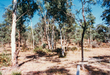
Photograph, Hohnes Reserve, Eltham Lower Park
... road eltham Colour photograph of bushland, Hohnes Reserve ...Colour photograph of bushland, Hohnes Reserve, Eltham Lower Parkeltham lower park, hohnes reserve, parks, bushland, hohnes road, eltham -
 Eltham District Historical Society Inc
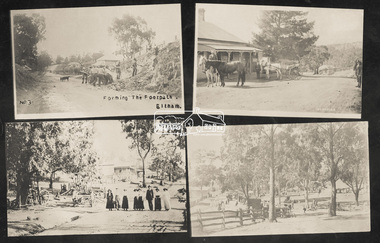
Photograph, Tom Prior, Group of scenes from the Eltham District, c.1905
Photo shows four images from the Shire of Eltham Pioneers Photograph Collection: SEPP_0501: West's Research Hotel, Main Road, Research, c.1907 SEPP_0612: Eltham, Main Road. Looking north from corner of Dudley Street, c.1904 SEPP_0616: Forming the footpath, Eltham, c.1906 SEPP_1000: Main Road, Hurstbridge, c.1905 Black and white/sepia photograph of four individual photographsbakery, eltham, eltham village reserve, footpath, gahan house, general store, haley's paddock, hurstbridge, luther haley, luther haley general store, main road, old mac (horse), picnic, pioneers and painters, punch (horse), railway store, research (vic.), research hotel, reynolds prior collection, richard reynolds, road construction, sepp, shire of eltham pioneers photograph collection, summer drinks, tilley lamp, york street -
 Eltham District Historical Society Inc
Photograph, Eucalyptus Road and Pitt Street/Nyora Road roundabout, Eltham
... melbourne Looking north along Eucalyptus Road, showing roundabout ...Looking north along Eucalyptus Road, showing roundabout at intersection of Pitt Street and Nyora Road, Eltham. Parks Victoria owns and manages the Pauline Toner Eltham Copper Butterfly Reserve on the left of the image. Colour photographeucalyptus road, pitt street, nyora road, roundabouts, eltham, pauline toner eltham copper butterfly reserve, pauline toner butterfly nature conservation reserve -
 Eltham District Historical Society Inc
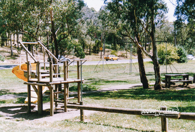
Photograph, Homestead Road, Eltham Lower Park
Eltham Lower Park, looking south west across playground area to Homestead Road, date unknowneltham lower park, parks, reserves, playgrounds, trees, eltham, hohnes hill -
 Warrnambool and District Historical Society Inc.
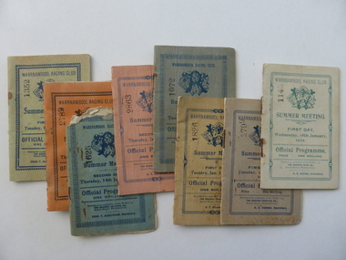
Document - Warrnambool. Woodford. Winslow. Purnim Race Books, Modern Print, W’Bool, Victoria, 1920's and 1930's
The Warrnambool Amateur Turf Club was first formed in September 1859, but didn't become a properly constituted club until April 1873, when a meeting was held at the Commercial Hotel, now the Whaler's Inn, and a committee was elected.Part of the present racecourse of 100 acres was set aside as a racing and recreation reserve in August 1855. It is one of the finest racecourses in Australia, ringed by the gentle slopes of a huge basin.The first race meeting was held on the course in August 1858. The Warrnambool Racing Club has managed racing at Warrnambool since it was formed on 5 April 1873.Apart from a number of smaller meetings held throughout the year, the feature of racing in the district is the Grand Annual Steeplechase. The first steeplechase over the now famous cross-country course was run on 13th June 1872 then known as the Grand Annual Steeplechase. The paddocks now know as Brierly and Granters were first used on that date. The course, over four miles, was made up of different kinds of jumps including a stone wall, a log fence, a ditch and parapet, a paling fence and numerous post and rails. The name Grand Annual was first used for this steeplechase in May 1895. It is the longest horse race in Australia, and the thirty three fences of the course, the most of any steeplechase in the world is raced over 5,500 metres. The three day May racing carnival is the major racing event on the horseracing and social calendar. Many of these race booklets relate to those May meetings. The Warrnambool Racecourse has been the home of district racing clubs such as Woodford, Purnim and Koroit over the latter part of the 20th century. The Woodford Racing club holds their annual meeting after Christmas each year. The Winslow races were held from approximately mid-19th century to around 1946. It began as a small picnic race club in Tobin’s paddock to a splendid race course on the property, “Green Hills” owned by Mr. John O’Keefe about one mile north of the Winslow township.. The annual meetings held on New Year’s Day drew crowds of seven to eight thousand people. All of these books contains family names which in some cases are still strongly linked to horse racing in the district.These booklets are a tangible link to a great sporting and social event in the Western District. A collection of programmes for race meetings. They relate to Warrnambool, Woodford, Purnim, Winslow and Victoria Racing Club meetings in the period 1922 to 1931. All are soft card covers with approximately 16 pages in each in white paper. They are numbered as follows: 001250.1 WRC Soft green cover with blue text 01/05/1923 001250.2 WRC Mauve cover with blue text 03/05/1923 001250.3 WRC fawn cover with red text 06/05/1924 001250.4 WRC Orange cover with blue text 08/05/1924 001250.5 WRC Soft green cover with light brown text 05/05/1925 001250.6 WRC Soft green cover with red text 07/05/1925 001250.7 WRC fawn cover with brown text 04/05/1926 001250.8 Woodford racing Club soft pink cover, Blue text 01/04/1922 001250.9 Woodford racing Club green cover, Blue text 07/04/1923 001250.9 Woodford racing Club grey cover, Blue text 05/04/1924 001250.10 Woodford racing Club grey cover, Blue text 05/04/1924 001250.11 Woodford Racing Club green cover, Blue text 22/11/1924 001250.12 Woodford Racing Club green cover, brown text 04/04/1925 001250.13 Woodford Racing Club orange cover, blue text 10/04/1926 001250.14 Woodford Racing Club pink cover, green text 10/04/1926 001250.15 Warrnambool Racing Club pink cover, blue text 18/11/1922 001250.16 Warrnambool Racing Club pink cover, red text 13/11/1926 001250.17 Warrnambool Racing Club cream cover, brown text 15/11/1924 001250.18 Warrnambool Racing Club cream cover, green text 18/01/1922 001250.19 Warrnambool Racing Club grey cover, blue text 15/01/1924 001250.20 Warrnambool Racing Club cream cover, blue text 13/01/1925 001250.21 Warrnambool Racing Club pink cover, blue text 15/01/1925 001250.22 Warrnambool Racing Club olive green cover, blue text 12/01/1926 001250.23 Warrnambool Racing Club blue cover, blue text 14/01/1926 001250.24 Warrnambool Racing Club soft green cover, blue text 13/01/1931 001250.24 Warrnambool Racing Club orange cover, black text 16/01/1930 001250.25 Warrnambool Racing Club orange cover, black text 16/01/1930 001250.26 Purnim Racing Club green cover, blue text 19/05/1924 001250.27 Winslow Racing Club pink cover,black text 21/04/1923 001250.28 Winslow Racing Club green cover,black text 06/12/1924 001250.29 Victoria Racing Club cream cover,green text 11/07//1923 001250.30 Victoria Racing Club cream cover, red text 14/07//1923 Most of the booklets have markings with place getters and jockeys marked in pencil. Warrnambool Racing club books have R U Forbes, C T Alexander A H Davies and William White as secretaries. Woodford club has Thomas Gleeson as secretary, Winslow 's secretary is W Latta and Purnim is P J Kelly. The local booklets are printed by The Modern Print Co Koroit St Warrnambool.warrnambool, warrnambool racing club, winslow racing club, woodford racing club, purnim racing club, victoria racing club -
 Warrnambool and District Historical Society Inc.
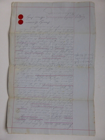
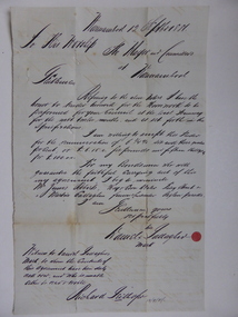
Document, Gauley contracts .1 & .2, C 1878
In 1858 a tramway was constructed to move goods between Warrnambool township and jetty on Lady Bay which was over a mile away The terminus was established on the southern side of Merri Street. and the track went around the edge of Lake Pertobe reserve. Large stores were also built near where the present railway station is situated to hold produce and carriages. These documents relate to contracts between Marion Gauley ,contractor of Warrnambool and the borough of Warrnambool for the operation of horse work with the tramway. John McDermid sadler,and William Stevens farmer of Russell's Creek are acting as surety for the contract.The tramway was an important part of Warrnambool's infrastructure and history and the documents also include names of local people. Of particular interest is the fact that the contract in this case was given to a woman which would have been a little uncommon at that time.001259.1 Pale blue lined paper with red lined outline.Hand written in black pen with names and some other words underlined in red. Two signatures on bottom right with red seal beside each. Witness signature below on left hand side. One page only 001259.2 Pale blue lined paper with red lined outline.Hand written in black pen with names and some other words underlined in red. Two signatures on bottom right with red seal beside each. Witness signature below on left hand side. Of the four pages of the document , only the first page is used. 001259.1 Signed Roady Carew and Moses Daly. Richard Daly is crossed out in the document and Marion Gauley is inserted in greylead. September 1878 001259.2 John McDermid saddler William Stevens, Marion Gauley. Ninth of December 1878. warrnambool, warrnambool tramway, marion gauley, john mcdermid, william stevens -
 Warrnambool and District Historical Society Inc.
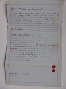
Document, Warrnambool Tramways-William Bell, C 1881
In 1858 a tramway was constructed to move goods between Warrnambool township and jetty on Lady Bay which was over a mile away The terminus was established on the southern side of Merri Street. and the track went around the edge of Lake Pertobe reserve. Large stores were also built near where the present railway station is situated to hold produce and carriages.This document is is a surety between John McDermit a saddler of Liebig Street Warrnambool along with Henry Phillips hay and corn dealer of Liebig Street Warrnambool, acting as surety in the amount of fifty pounds to William Bell a contractor to perform horse work for the Warrnambool tramways. for a period of one year, 1881-1882. This contract has a strong historical link to one of Warrnambool's earliest infrastructure projects . It contains the names of local people and provides an insight into the links between people and the types of work they undertook Pale blue lined paper with red lined outline.Hand written in black pen with names and some other words underlined in red. Two signatures on bottom right with red seal beside each. Witness signature below on left hand side. Of the four pages of the document , only the first page is used.Signed John McDermid, Henry Phillips. 1st October 1881.warrnambool,, warrnambool history, warrnambool tramways, william bell contract,, john mcdermid, henry phillips -
 Warrnambool and District Historical Society Inc.
Document, Gallagher, C 1881
In 1858 a tramway was constructed to move goods between Warrnambool township and jetty on Lady Bay which was over a mile away The terminus was established on the southern side of Merri Street. and the track went around the edge of Lake Pertobe reserve. Large stores were also built near where the present railway station is situated to hold produce and carriages. These documents relate to the contract to perform the horse work for the tramway for a period of one year. The horse work involved the transporting of goods by horse drawn tram trucks, all repairs to the tracks , shunting and delivery duties. The tramway operated from 7 am to 6 pm six days a week and a team of six horses was required to perform the work.The tramway was an important part of Warrnambool's infrastructure and history and the documents also include names of local people.001261.1 Pale blue lined paper with red lined outline.Hand written in black pen with names and some other words underlined in red. Two signatures on bottom right with red seal beside each. Witness signature below on left hand side. Of the four pages of the document , only the first page is used. 001261.2 Cream paper lined in blue with heavy black ink writing. A red seal attached beside the tenderer's mark and name. on right side of page. Witness's signature at bottom centre of page.001261.1 James Roberts hay and corn dealer ,Fairy Street Warrnambool, Martin Callaghanfarmer and contractor Raglan Parade Warrnambool. Daniel Gallagher, contractor of Warrnambool. September 1881. 001261.1 Daniel Gallagher .James Roberts Martin Callaghan September 12, 1881.warrnambool, warrnambool history, daniel gallagher, james roberts -
 Warrnambool and District Historical Society Inc.
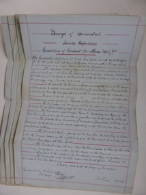
Document, Conditions of contract for Horse work Tramway Department, C1881
In 1858 a tramway was constructed to move goods between Warrnambool township and jetty on Lady Bay which was over a mile away The terminus was established on the southern side of Merri Street. and the track went around the edge of Lake Pertobe reserve. Large stores were also built near where the present railway station is situated to hold produce and carriages. According to these documents , the horses were required for many different tasks in the operation of the tramways including the moving of freight, removal of sand from the area, shunting of trucks and ballasting and repairing lines when necessary.The contractors had a list of conditions imposed including the provision of six horses of strong working ability and sufficient finances. The contract period was for 1 year and payment was monthly in arrears and hours of operation were from 7 am to 6 pm. These handwritten documents provide an insight into the type of work done in the early days of Warrnambool and the working conditions at the time. Five folded grey paper with red lines around edges. Written in black ink. Only front page of each piece has writing on it. 001262.1 Borough of Warrnambool Tramway Department Specification of Duties Contractor for Horse Work Signed William Bell 28/09/1881 001262.2 Borough of Warrnambool Tramway Department Conditions of contract for Horse Work. Signed Daniel Gallagher 20/09/1881 001262.3 Borough of Warrnambool Tramway Department Specification of Duties Contractor for Horse Work Signed Daniel Gallagher 20/09/1881. 001262.4 Borough of Warrnambool Tramway Department Specification of Duties Contractor for Horse Work Signed Michl Daly 5th September 1878 crossed out 001262.5 Borough of Warrnambool Tramway Department Conditions of contract for Horse Work Signed William Bell 28/09/1881warrnambool, warrnambool tramway, horse work, tramway contract -
 Warrnambool RSL Sub Branch
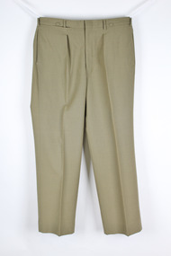
Army Uniform trousers, Polyester Trousers, 1989
This item of uniform was own, worn and donated by Major (Retd) Bernard Farley during service in the Army Reserve Infantry at 8/7 Royal Victoria Regiment (RVR) Ballarat VICPolyester trousers with two side pockets, one back pocket, money pocket with belt loops and brass ceremonial belt keepersTag - A.D.I. P/L VIC 1989 ARROW indicating Govt. NSN 8405-66-0185-5522 MACQUARIE 89, Batch C Size. 80RF W.90 L.77 NAME. SERVICE NO. DRY CLEAN ONLY(A) Press on original creases. Use damp cloth. Medium to hot steam iron -
 Warrnambool RSL Sub Branch
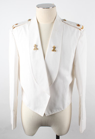
Dress Jacket Army Reserve, Fletcher Jones & Staff, 1998
This jacket is part of the dress uniform of a Major in the Army Reserve. Major Bernard Farley who owned this jacket wore it to official functions in the Mess dining room. He served in this capacity from 1998-2001.Bernard also served in the RAAF for a number of years.This jacket has significance as it is typical of dress requirements which were worn to official Army functions.Short white jacket with wide front lapels epaulets at the shoulders and a small V shaped downward peak at the back. The sleeves have a stitched over section at the cuff with a point in line with the shoulder. On each epaulet from the collar edge side there is a brass coloured button with the Rising Sun in low relief and on the lower edge of the epaulet a brass coloured crown with red nsert and a circular shaped badge with the word Australia. There is a badge on each lapel two crossed rifles holding a crown in brass colour over the top of a silver VLabel states ,' Fetcher Jones Victoria 1998 NSN 8405-NIC Name....... Service No......... Polyester / Viscose Dry Cleanable ( A) Warm Gentle Machine Wash Rinse well. Warm iron. ZC785 BR1689 425267911.ZC785 107 R 347 044 05037649 cloth br 1689 17. J10129 OW Wwarrnambool, army reserve, dress jacket -
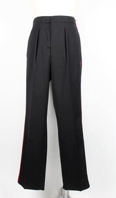 Warrnambool RSL Sub Branch
Dress Trousers Army Reserve, Fletcher Jones & Staff, 1998
This jacket is part of the dress uniform of a Major in the Army Reserve. Major Bernard Farley who owned this jacket wore it to official functions in the Mess dining room. He served in this capacity from 1998-2001. Bernard also served in the RAAF for a number of years.These trousers are part of the dress uniform of a Major in the Army Reserve. Major Bernard Farley, who owned the uniform, wore it to official functions in the Mess dining room. He served in this capacity from 1998-2001. Bernard also served in the RAAF for a number of years.Long black trousers with a single red stripe running down either side from the top of the waistband to the base of the legs. There are two pockets just eunderneath the waistband on either side of the trousers. The fabric frms two stiff peaks at the centre of the back of the waistband. The trousers have a black zip with a metallic clip just above and six black plastic buttons along the interior of the waistband. There is one white square label with inscriptions attached to the back/left of the interior section of the waistband. Directly underneath this is another rectangular white label of the same length however much shorter. This also has inscriptions.Inscriptions on the larger square label: Fletcher Jones / Victoria / 1998 / NSN: 8405-66-095-9737 / NAME........... / SERVICE NO............ / 70% Wool / 30% Polyester / DRY CLEAN ONLY (A) / Press on original creases. Use damp cloth. Medium to hot iron / ZT782 AR0009 Inscriptions on the smaller rectangular label: 425267283.ZT782G / 94-92-76 / 347 044 07063222 / CLOTH / AR0009 / . . 5 . D40. 5 / J10066. . W *army reserve, dress uniform, dress trousers, trousers, army uniform, uniform, bernard farley, farley, warrnambool rsl, warrnambool -
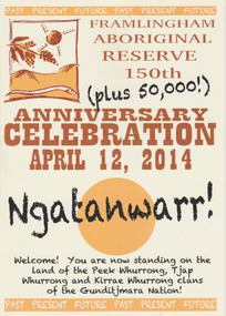 Warrnambool and District Historical Society Inc.
Booklet - 150 plus Framlingham Aboriginal Reserve, 2014
The Framlingham Aboriginal Trust is a shareholder- owned organization established under Victorian law in 1971. The Trust owns and manages part of what was the old Aboriginal Reserve established in 1861 under the auspices of the Church of England. In 1865 the Reserve was officially established as a Government-managed aboriginal station. By 1970 the original area of 3,500 acres was whittled down to 585 acres and handed over to the Framlingham Aboriginal Trust. Framlingham is today one of only two discrete aboriginal communities in Victoria where aborigines live on aboriginal land and is an important part of the district cultural life. The celebration of the 150th anniversary of Framlingham’s establishment in 2014 was therefore a significant event in the district’s history and the booklet is a permanent reminder of this.This is a small booklet of 8 pages containing information on the 150th celebrations of Framlingham Aboriginal Reserve in 2014. The cover has a cream background with illustrations and printed material in yellow, black and brown. The pages are stapled. The booklet includes photographs, maps, illustrations and printed material. Front cover: ‘Framlingham Aboriginal Reserve 150th Anniversary Celebration, April 12, 2014, Ngatanwarr’ etc Back cover: Acknowledgements of sponsors and written material framlingham aboriginal trust, western district aborigines, peek whurrong, kirrae whurrong, gunditjmara, tjap whurrong -
 Eltham District Historical Society Inc
Negative - Photograph, The Bridge, Hurstbridge, Vic, c.1925
Copied from brochure "Wattle Valley Estate" 7 minutes from the bridge. The new bridge designed by Sir John Monash over the Diamond Creek near Hurst's home of 'Mia Mia' at Hurstbridge. The Wattle Valley Estate was first advertised in August 1925 as weekend building allotments by the Greater Melbourne Land and Development Company. Advertised from £28.10.0 or £60 per block. In August 1926, 30 picked allotments of 60x150 feet were put up for auction Saturday August 14, 1926 with frontages to Valley View Road and Fawkner Crescent advertised in the “Heart of the Glorious Wattle Country” and “Within 15 Minutes of the Newly Electrified Railway Station”. The Advertiser on August 13, 1926 in an article promoting the auction stated “the estate is regarded as one of the best in the district, and will be sold practically without reserve.” It is noted that an advertisement running in The Argus February 22, 1951 offered the remaining 16 blocks for sale at £12.10.0 or £200 the lot. By March 7, the remaining blocks were advertised at £17.10.0 The Wattle Valley Estate took over 20 years to sell and then people could not build on them This image was also used in a brochure advertising the "Wattle Valley Estate", which forms part of the Shire of Eltham Pioneers Photograph Collection (Cross Reference Photo No.(s): 1056, 1057)This photo forms part of a collection of photographs gathered by the Shire of Eltham for their centenary project book,"Pioneers and Painters: 100 years of the Shire of Eltham" by Alan Marshall (1971). The collection of over 500 images is held in partnership between Eltham District Historical Society and Yarra Plenty Regional Library (Eltham Library) and is now formally known as the 'The Shire of Eltham Pioneers Photograph Collection.' It is significant in being the first community sourced collection representing the places and people of the Shire's first one hundred years.Digital image 4 x 5 inch B&W Negshire of eltham pioneers photograph collection, hurstbridge, bridge, diamond creek (creek), monash bridge, wattle valley estate -
 Eltham District Historical Society Inc
Negative - Photograph, Rose Stereograph Company, The Bridge, Hurstbridge, Vic, c.1925
Copied from brochure "Wattle Valley Estate". The new bridge designed by Sir John Monash over the Diamond Creek near Hurst's original home "Mia Mia" seen in the distance. Reprinted from brochure advertising "Wattle Valley Estate" 7 minutes from bridge. The Wattle Valley Estate was first advertised in August 1925 as weekend building allotments by the Greater Melbourne Land and Development Company. Advertised from £28.10.0 or £60 per block. In August 1926, 30 picked allotments of 60x150 feet were put up for auction Saturday August 14, 1926 with frontages to Valley View Road and Fawkner Crescent advertised in the “Heart of the Glorious Wattle Country” and “Within 15 Minutes of the Newly Electrified Railway Station”. The Advertiser on August 13, 1926 in an article promoting the auction stated “the estate is regarded as one of the best in the district, and will be sold practically without reserve.” It is noted that an advertisement running in The Argus February 22, 1951 offered the remaining 16 blocks for sale at £12.10.0 or £200 the lot. By March 7, the remaining blocks were advertised at £17.10.0 The Wattle Valley Estate took over 20 years to sell and then people could not build on them This image was also used in a brochure advertising the "Wattle Valley Estate", which forms part of the Shire of Eltham Pioneers Photograph Collection (Cross Reference Photo No.(s): 1056, 1057). Also cross reference SEPP_1028 / 29 for other views of Mia Mia. Part of a slide show presentation "Bridges & Waterways of the Shire" by Russell Yeoman to the 13 September 1989 Society meeting. The presentation included slides of historic photos from the Shire of Eltham Pioneers collections as well as several recent views. This photo forms part of a collection of photographs gathered by the Shire of Eltham for their centenary project book,"Pioneers and Painters: 100 years of the Shire of Eltham" by Alan Marshall (1971). The collection of over 500 images is held in partnership between Eltham District Historical Society and Yarra Plenty Regional Library (Eltham Library) and is now formally known as the 'The Shire of Eltham Pioneers Photograph Collection.' It is significant in being the first community sourced collection representing the places and people of the Shire's first one hundred years.Digital image 4 x 5 inch B&W Negshire of eltham pioneers photograph collection, hurstbridge, mia mia, bridge, diamond creek (creek), monash bridge, wattle valley estate -
 Eltham District Historical Society Inc
Negative - Photograph, Popular Picnicing at Hurstbridge, c.1925
Picnickers enjoying a Sunday outing near the Wattle Valley Estate at Hurstbridge. Copied from brochure "Wattle Valley Estate". It is believed the picture is taken at the northwest corner of the intersection of Wattletree Road and Hurstbridge-Arthurs Creek Road looking southeast towards the township (most likely where the house is located on the property of what is today No. 2 Wattletree Road)- https://goo.gl/maps/VDorwCe1rJJUapjE6 According to a comment by Jean Verso (via @nillumbikcouncil FB page 3 Jan 2020) - "This view is from Wattle Tree Road with Haleys Gully Road to the right and across the creek to William Gray's nursery at Allwood. The building to the far left looks like Dorset House. The building on the left in the middle distance is still there today and has been used for storage and as a stable/tack room for a number of years." The Wattle Valley Estate was first advertised in August 1925 as weekend building allotments by the Greater Melbourne Land and Development Company. Advertised from £28.10.0 or £60 per block. In August 1926, 30 picked allotments of 60x150 feet were put up for auction Saturday August 14, 1926 with frontages to Valley View Road and Fawkner Crescent advertised in the “Heart of the Glorious Wattle Country” and “Within 15 Minutes of the Newly Electrified Railway Station”. The Advertiser on August 13, 1926 in an article promoting the auction stated “the estate is regarded as one of the best in the district, and will be sold practically without reserve.” It is noted that an advertisement running in The Argus February 22, 1951 offered the remaining 16 blocks for sale at £12.10.0 or £200 the lot. By March 7, the remaining blocks were advertised at £17.10.0 The Wattle Valley Estate took over 20 years to sell and then people could not build on them Cross Ref EDHS_02665 Rose Series Postcard P. 4341, "View at Hurstbridge, Vic." Also, other images from sales brochure SEPP_1055 / 1056This photo forms part of a collection of photographs gathered by the Shire of Eltham for their centenary project book,"Pioneers and Painters: 100 years of the Shire of Eltham" by Alan Marshall (1971). The collection of over 500 images is held in partnership between Eltham District Historical Society and Yarra Plenty Regional Library (Eltham Library) and is now formally known as the 'The Shire of Eltham Pioneers Photograph Collection.' It is significant in being the first community sourced collection representing the places and people of the Shire's first one hundred years.Digital image 4 x 5 inch B&W Neg1925, dorset house, fawkner crescent, haleys gully road, hurstbridge, hurstbridge-arthurs creek road, picnic, postcards, shire of eltham pioneers photograph collection, valley view road, wattle valley estate, wattletree road, exhibition yprl 2019-12 -
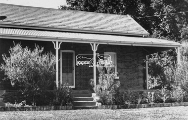 Eltham District Historical Society Inc
Negative - Photograph, Leader Publishing Co, Wingrove Cottage, c.1970
Wingrove Cottage is historically significant for its long association with Charles Wingrove, a prominent figure in Victorian local government, as secretary to the Eltham District Road Board and Shire Council from 1858 to 1904, and Shire Engineer and Secretary to the Heidelberg Road Board. The cottage was also used as the office of the Eltham District Road Board and Council for many years . One of the Shire's oldest dwellings, and one of the few surviving 19th century buildings associated with early Eltham and located in the original Eltham Village Reserve. Wingrove Cottage is considered historically significant to the Shire of Nillumbik and is registered on the Victorian Heritage Database. This photo forms part of a collection of photographs gathered by the Shire of Eltham for their centenary project book,"Pioneers and Painters: 100 years of the Shire of Eltham" by Alan Marshall (1971). The collection of over 500 images is held in partnership between Eltham District Historical Society and Yarra Plenty Regional Library (Eltham Library) and is now formally known as the 'The Shire of Eltham Pioneers Photograph Collection.' It is significant in being the first community sourced collection representing the places and people of the Shire's first one hundred years.Digital image 4 x 5 inch B&W Neg Print 20 x 25 cmsepp, shire of eltham pioneers photograph collection, eltham, wingrove cottage, charles wingrove, houses -
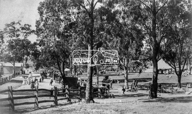 Eltham District Historical Society Inc
Negative - Photograph, Tom Prior (prob.), A peep at the picnickers, Eltham, c.1904
... main road bakery eltham village reserve general store haley's ...Reproduced ‘Pioneers & Painters’ pp 52-53. Picnickers enjoying a Sunday outing in the fields opposite Eltham Railway Station. Looking north towards Research along Main Road near the intersection with Dudley Street. Luther Hayley’s Bakery and General Store on left promoting refreshments and summer drinks. With the opening of the railway to Eltham in 1902, Melbourne residents would regularly enjoy a Sunday excursion journey on the train to Eltham for a day’s outing to the countryside. Possibly the annual State schools picnic held by the Board of Advice at Haley's Paddock near Eltham railway station on 11 March, 1904. Haley’s Paddock (now occupied by Eltham shopping centre) was capable of accommodating 10,000 people, with ample shade and hilly surroundings, an ideal place for any gathering. The main foreground is the site of the present day Eltham Village and Coles Shopping Centre. This photo forms part of a collection of photographs gathered by the Shire of Eltham for their centenary project book,"Pioneers and Painters: 100 years of the Shire of Eltham" by Alan Marshall (1971). The collection of over 500 images is held in partnership between Eltham District Historical Society and Yarra Plenty Regional Library (Eltham Library) and is now formally known as the 'The Shire of Eltham Pioneers Photograph Collection.' It is significant in being the first community sourced collection representing the places and people of the Shire's first one hundred years.Digital image 4 x 5 inch B&W Neg Print 20 x 25 cmshire of eltham pioneers photograph collection, eltham, main road, bakery, eltham village reserve, general store, haley's paddock, luther haley, luther haley general store, picnic, pioneers and painters, railway store, summer drinks -
 Eltham District Historical Society Inc
Document, Notice of Decision to Grant a Permit; Ref: E94/306 - Subdivision of 30-34 Diosma Road; 16 November 1994, 16/11/1994
This permit was eventually overturned following community objection and the land was donated by Yarra Valley Water for use as a community reserve.The Stokes Orchard Estate collection is typical of housing developments of the late 1970s and 1980s. It was one of the earliest estates in Eltham following the nearby Woodridge Estate development.A4 document consisting of ten pagesAs notedstokes place, eltham, stokes orchard, stokes orchard estate, streets, houses, peter and carla vermey, diosma road, letter of objection, melbourne metropolitan board of works, planning application, reservoir, shire of eltham -
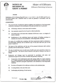
 Eltham District Historical Society Inc
Photograph, Members of the community gather on the site of the former Shire of Eltham offices, Save Community Reserves Rally, Main Road, Eltham, 4 March 2018, 4/3/2018
... ' proposal to sell off 17 community reserves. Held at the site ...Protest rally against Nillumbik Shire Councillors' proposal to sell off 17 community reserves. Held at the site of the former Shire of Eltham offices, at 895 Main Road, which were demolished in August 1996, followed by a march along Main Road finishing at the Eltham Railway Station car park at Luck Street. Estimated attendance was approximately 3,000.Born digital image (8)nillumbik shire council, parks, save community reserves, protest rally -
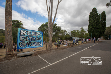
 Eltham District Historical Society Inc
Photograph, The Chocolate Lilies Choir kick off the entertainment, Save Community Reserves Rally, Main Road, Eltham, 4 March 2018, 4/3/2018
... , Save Community Reserves Rally, Main Road, Eltham, 4 March 2018 ...Protest rally against Nillumbik Shire Councillors' proposal to sell off 17 community reserves. Held at the site of the former Shire of Eltham offices, at 895 Main Road, which were demolished in August 1996, followed by a march along Main Road finishing at the Eltham Railway Station car park at Luck Street. Estimated attendance was approximately 3,000.Born digital image (15)nillumbik shire council, parks, save community reserves, protest rally -
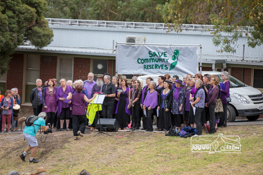
 Eltham District Historical Society Inc
Photograph, Nerida Kirov, one of the rally organisers, addresses the crowd, Save Community Reserves Rally, Main Road, Eltham, 4 March 2018, 4/3/2018
... the crowd, Save Community Reserves Rally, Main Road, Eltham, 4 March ...Protest rally against Nillumbik Shire Councillors' proposal to sell off 17 community reserves. Held at the site of the former Shire of Eltham offices, at 895 Main Road, which were demolished in August 1996, followed by a march along Main Road finishing at the Eltham Railway Station car park at Luck Street. Estimated attendance was approximately 3,000.Born digital image (16)nillumbik shire council, parks, save community reserves, protest rally