Showing 7124 items matching "snowy-river"
-
 Forests Commission Retired Personnel Association (FCRPA)
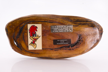
Presentation plaque from the "Woodpeckers"
In the post-war era from 1947 to the mid-1980s, the Forests Commission sponsored Australia's only military sawmilling unit, the 91 Forestry Squadron. It was a special reserve unit of the Royal Australian Engineers (RAE). Established and commanded by Commission forester and WW2 veteran, Major Ben Benallack, the "Woodpeckers" as they were known comprised a small pool of specialised soldiers capable of rapid mobilisation in the event of need. Several other Victorian departments such as the State Electricity Commission (SEC) did the same thing who supported a construction squadron based at Newborough in the Latrobe Valley. The scheme created a very active and capable part-time military group that completed many worthy projects across the State. In addition to their military training, the Woodpeckers operated bush sawmills, built timber bridges along the Murray River, the Snake Island Jetty, forest roads and performed various demolition tasks.Presentation plaque from the "Woodpeckers" Mounted on polished wooden burl forests commission victoria (fcv) -
 Eltham District Historical Society Inc
Journal - Newsletter, Newsletter, No. 274 February 2024
Contents: • 2024 – a year of many anniversaries by Jim Connor • Our Next Meeting - 7.30pm Wednesday 14th February 2024 • Heritage Excursion - Saturday 2nd March 2024 – Walking the Kurrum Yallock (Plenty River) • The beginning of Local Government in Eltham by Jim Connor • Alan Marshall – An Anniversary by Jim Connor • Book Review – Michael Wilson, Eltham Goldsmith and Sculptor – My Journey • Montsalvat People by Richard Pinn o Justus Jorgensen (1893-1975) o Betty Roland (1903-1996) • Two Eltham Women Served in WW1 by Terry Beaton • Brief Comparison Between WW1 and WW2 by Terry Beaton • Recollections of Marcus Skipper • Eltham Cemetery Stories by Liz Pidgeon o Lena Cooper Skipper, nee Wilshire, 1889-1970, Painter and Montsalvat Founder • Experience Eltham Cemetery: The founding members by Julia Drew The Shire of Eltham Historical Society was formed in October 1967. The first newsletter of the Society was issued May 1978 and has been published continuously ever since on a bi-monthly basis. With the cessation of the Shire of Eltham in late 1994, the Society's name was revised to Eltham District Historical Society and this name first appeared with issue No. 103, July 1995. The collection of the Society's newsletters provides a valuable resource on the history of the Society's activities, office bearers and committee members, guest speakers and subjects of historical interest pertinent to the former Shire of Eltham and the Eltham District.A4 newsletter distributed to members (Digital and A4 photocopy)newsletter, eltham district historical society -
 Melbourne Tram Museum
Postcard, Rose Stereograph Co, "Melbourne from the Air", early 1940s
Rose Series postcard No. P 622, titled ""Melbourne from the Air", Photo looking east over Melbourne with the Melbourne skyline, railway yards, St Kilda Road, Yarra River and Princes Bridge in the view. Three trams can be seen in the view in St Kilda Road. The building in the middle bottom of the photo is the recently completed Australian Provincial Assurance (APA) Assocation Limited Head Office on the south east corner of Collins and Queen Streets. This 1889 building was refaced and the tower added in 1928-1929. The adding of three additional floors to the Bank of Australasia building, 1875-1876, is well in hand 1929-1931 on the north west corner of Queen and Collins Streets. On the south east corner of the corner of Collins and Market Streets, the new Australian Mutual Provident (AMP) Society Head Office is reaching full height, also constructed 1929-1931. Yields information about an aerial view of Melbourne C1930Postcard - printed real photograph with Rose Stereograph Co. name on the rear.tramways, trams, aerial views, melbourne, collins st. -
 Lakes Entrance Historical Society
Photograph, 1914 c
Ema and Carrie Appleby, Will and Eva Bell, Jessie Bligh, Lena Brideson, George Bell, Carrie Froud, Phyllis Bert, Addie, Marion, May, Arthur Howlett, Fred, Marion, Alf and Gladys Legg, Jim and Mabel Thompson at a picnic on banks of Tambo River Bumberrah Victoria. Also a black and white photograph taken after marriage of Eva Howlett to William Bell on 29 February 1916 indentified are Charles, Ethel and Keith Batten, Leah, Lena Brideson, Jane Brodribb, Chaplain Carroll, Janet Duncan, Mr and Mrs Enright, Carrie Froud, Ada Grant, Mrs Healy, Herb, Marion, May, Maud Howlett, Fred, Marion and George Legg, Mr and Mrs Payne, Belle Thexton, Jim, Mabel and Edna Thompson, Mr Wilson dark copy 04411.2 , 10 x 13 cmBlack and white photograph of twenty three adults and children members and friends of the Howlett family,. Also a black and white photograph taken after marriage of Eva Howlett to William Bell on 29 February 1916 genealogy, families -
 Flagstaff Hill Maritime Museum and Village
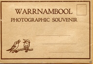
Postcard - Postcard Folder, scenes, Valentine & Sons Co. Publishing Ltd, Warrnambool Photographic Souvenir, Early-to-mod 20th century
This postcard folder is one of three in a set of postcards that were published in Victoria, Australia, and collected together. The Valentine Publishing Co. Pty. Ltd. produced this folder. Valentine and Sons was a printing and photography business based in Dundee, Scotland, and in Canada. In the early 1900s, at the height of the postcard craze, the firm published large numbers of postcards in the U.K., Canada, U.S., Australia and South Africa. From around 1900 or earlier, the firm bought many lithographic images for its postcards from local and national photographers who sold publishing rights to Valentines, and the business was famous for publishing photographs of popular sites worldwide. Postcard titles in this folder include many of those in the Rose postcard folders plus the following titles that are not duplicated. . Municipal Buildings and Post Office . Soldiers’ Memorial . Hopkins River . The Cliffs at Shelly Beach . The Road to Sandy Beach . The Breakwater and Pier This Valentine postcard folder was produced in Australia. It includes pictures from the early-to-mid 20th century. It is one of three in a set, with images of the same locations as other images in our collection but at different periods in time. Each postcard records a moment in history and is significant as a way to compare and show the changes in the local environment and community, building a story of the local history. The images record changes in the coastline, land, bay, buildings and other structures, roads, transportation and even the fashions of the times.Postcard folder, Valentine Publishing, cream cover. One of a set of three displaying images of Warrnambool and district around the mid-20th century. Print on the front and back covers is in brown ink. The front has an image of two laughing kookaburras on a branch, three address lines and an outline for a postage stamp. The back cover has the publisher’s details and a line for a return address. The cover opens like a book, and then the double-sided, Z-folded page of photographs drops downward. Titles are printed below each of the fifteen black and white photographs inside. The folder is secured on the back cover by placing a tab into a slot. The folder was produced by The Valentine Publishing Co. Pty. Ltd. Melbourne“WARRNAMBOOL / PHOTOGRAPHIC SOUVENIR” Symbol: [Two facing kookaburras standing on a branch with beaks open] “Published by The Valentine Publishing Co. Pty. Ltd. Melbourne” flagstaff hill maritime museum and village, great ocean road, shipwreck coast, warrnambool, flagstaff hill, flagstaff hill maritime museum, flagstaff hill maritime village, warramble, postcard, postcard folder, warrnambool scenes, picturesque views of warrnambool, picturesque views of warramble, lady bay, port of warrnambool, breakwater, warrnambool breakwater, viaduct, merri river footbridge, merri river suspension bridge, suspension footbridge, merri river mouth, hopkins river mouth, proudfoot's, fanny nelson, nelson's boatsheds, nelson's boathouse, boathouse, hopkins river boathouses, flett's boathouse, flett, george rose, image of a rose, rose series, rose stereograph co, rose stereographic company, lighograph, armadale victoria, lady bay beach, beach scene, lower light, concrete footbridge, 1922 footbridge, viaduct road, rose postcard, new concrete bridge, 1945, 1890, 1922, small footbridge, 1872 footbridge, 1872, merri river estuary, stingray bay, postcards, concertina fold, z fold, shipwrecked coast, maritime museum, souvenir, warrnambool local scenes, photography, local history, tourism, photographs, visitors, travel, scenes, mid-20th century, 1940s, 1950s, z-fold, 1880s, collection, correspondence, valentine publishing co. pty. ltd melbourne, valentine publishing co. pty. ltd sydney, municipal buildings and post office, soldiers’ memorial, hopkins river, the cliffs at shelly beach, the road to sandy beach, the breakwater and pier -
 Marysville & District Historical Society
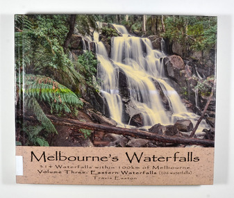
Book - Hardcover book, Travis Easton, Waterfalls of Victoria-Volume Three-Eastern Waterfalls, 2015
A book of photographs and information pertaining to the waterfalls in Eastern Victoria.A book of photographs and information pertaining to the waterfalls in Eastern Victoria.Hardcover. Front cover has a photograph of Toorongo Falls and back cover has a photograph of Evelyn Falls with a synopsis of the book.Gift fo Marysville & District Historical Society by Travis. 17 After catching up with my family because I had lingered to take a few more photographs,/ I was serenaded with the following song:/ Don't go chasing waterfalls/ Please stick to the rivers and the lakes that you're used to/ I know that you're gonna have it your way or nothing at all/ but I think you're moving too fast/ from the song Waterfalls by TLC Dedicated to my wife and children: Monique, Iona, Zahra, Jasmine & Flynn,/ who have continued to love me despite my waterfall chasing ways.waterfalls, eastern victoria, travis easton, photographs -
 Ringwood and District Historical Society
Document, An excerpt of the account book from Charles Newman 1860-1893, including marriage certificate of Mary Ann Newman, daughter of Charles, to Edward Richard Crosswell
An excerpt of the account book from Charles Newman 1860-1893, including marriage certificate of Mary Ann Newman, daughter of Charles, to Edward Richard Crosswell on 13 July 1865 at St Paul’s Church, Melbourne. Major Charles Newman (1795-1866) had one of the first pastoral holdings east of Melbourne in the 1830s. It was located around the confluence of the Yarra River and the Mullum Mullum (or Deep) Creek. The family built the historic, and heritage-listed, Pontville Homestead, constructed in the 1840s and still there today. Caroline Madden, who married Nicholas Madden, one--time owner of the Coach & Horses Hotel, was the daughter of Edward Crosswell. -
 Eltham District Historical Society Inc
Photograph - Digital Photograph, Alan King, Sweeney's Cottage, Sweeneys Lane, Eltham, 30 January 2008
Part of the original cottage named Culla Hill built by Thomas Sweeney (a former convict) remains as a small section of today’s house. Covered under Heritage Overlay, Nillumbik Planning Scheme National Estate National Trust of Australia (Victoria) Local Sifgnificance Published: Nillumbik Now and Then / Marguerite Marshall 2008; photographs Alan King with Marguerite Marshall.; p19 Thomas Sweeney, a former convict who became a respected citizen, once lived on a property at what is now the corner of Sweeneys Lane and Culla Hill, Eltham. As Sweeney was one of the district’s first settlers, the property is registered by the National Trust. Thomas Sweeney was born in 1802, son of impoverished tenant farmers in Tipperary County, Ireland. He became a ploughman, then at 21 he was sentenced to hang for setting on fire the house of Patrick Guyder at Gullshill. It is said the arson was due to a dispute over undelivered guns to a social justice guerilla group, the White Boys, of which Sweeney was a member. But the sentence was commuted to life transportation to Australia in 1823.1 Apparently in Sydney he became a servant to James Chandler at Botany. Soon James Chandler leased his farm and became a catechist on the Hawkesbury River, so Sweeney was reassigned to a former convict, John Brown, at Liverpool. Later Sweeney was assigned to George Brown of Lake Illawarra. In 1831, Sweeney was granted a ticket-of-leave and bought a boat to carry goods between Illawarra district and Sydney Town. He married his first wife who had come to Australia as a free woman. However she drowned after bearing him a daughter. In 1838, one month after he had received a conditional pardon, Sweeney married a blacksmith’s daughter, Margaret Meehan, newly arrived from Ireland. They then moved to Port Phillip and squatted on the south side of the Yarra River, about seven miles (11km) from Melbourne. Around 1842, Sweeney bought 110 acres (44.5ha) in the parish of Nillumbik for £110. He built a slab hut 12 x 10 feet (3.6m x 3m) and then his homestead, Culla Hill, a typical Tipperary style cottage, now known as Sweeney’s Cottage. It was here that many generations of Sweeneys lived for almost 100 years. Culla Hill became a social centre for the district and the Catholic community used it as a church. Sweeney was apparently on good terms with a tribe of Aborigines living on the river nearby, who helped him build his house.2 Sweeney proved himself a civic-minded leader. In 1844, he led a call for a bridge over the Plenty River. He was on the first school board and supplied the first grain for Eltham’s mill. Sweeney profited during the gold rush, not by gold digging, but by providing supplies for nearby fields and others as far away as Beechworth.3 Thomas Sweeney died in 1867 and was buried at the Eltham Cemetery, leaving two sons, five daughters, and 300 acres (121.4ha), as well as Culla Hill. Culla Hill – by then reduced to 75 acres (30ha) – was sold out of the family in 1939, then renamed Sweeneys. The present Sweeneys Lane, running diagonally through the original holding, was the track to the house. Part of the original cottage remains as a small section of today’s house. The dining-family room fronted by a veranda is original, and although there have been some changes, the cedar door and most of the small 12-paned wooden-framed windows are original. The walls are made of the original hand-made brick. After buying the property in 1952 Mr and Mrs Burston demolished a dilapidated slab hut, a three-roomed detached kitchen and cellar, as materials needed to restore them were very difficult to obtain so soon after the war.4 However the barn remains almost in its original condition. It is believed to have been built from stone quarried on the property. Now roofed with iron sheets it was probably originally thatched. The sandstone barn has a peaked roof supported by the original saplings and a doorway large enough to accommodate a fully loaded wagon.This collection of almost 130 photos about places and people within the Shire of Nillumbik, an urban and rural municipality in Melbourne's north, contributes to an understanding of the history of the Shire. Published in 2008 immediately prior to the Black Saturday bushfires of February 7, 2009, it documents sites that were impacted, and in some cases destroyed by the fires. It includes photographs taken especially for the publication, creating a unique time capsule representing the Shire in the early 21st century. It remains the most recent comprehenesive publication devoted to the Shire's history connecting local residents to the past. nillumbik now and then (marshall-king) collection, culla hill, eltham, sweeney's cottage, sweeneys lane, thomas sweeney -
 Eltham District Historical Society Inc
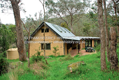
Photograph - Digital Photograph, Jim Connor, Birrarung House, 195 Laughing Waters Road, Eltham, 7 September 2013
Laughing Waters Walk, 7 Sep 2013 This Society excursion was a follow up to the Laughing Waters Story told to us by Jane Woollard at our Annual General Meeting in March 2013. It involved a walk commencing from the corner of Laughing Waters and Overbank Roads along Laughing Waters Road to its eastern end and returning partly over the same route - a total distance of about 2.5km. On the way we visited the two artist in residence properties, River Bend and Birrarung, to view the houses on them that are associated with Alistair Knox, Gordon Ford and others in the local mud brick and artistic community. We also able to walk around the derelict ruin which was once home to Gordon and Sue Ford, Boomerang House. An unexpected afternoon tea was offered to us by the artists in residence at Birrarung House and we had a brief opportunity to view inside the house. Birrarung is situated near the end of Laughing Waters Road. It was built in 1974 by Graeme Rose for Gordon Ford who he had asked to build him a small ‘bach’. Builder Peter Jarvis who did his apprenticeship with Alistair Knox for a couple of years recalled there were no drawings. It evolved as more funds became available. Graeme would source second-hand building materials around which he would shape the house. The fireplace was built with chicken wire over which it was rendered with faro cement. A brick floored glass studio, added later, faces a wall of boulders pressed into a manmade cliff, a large pond the link between the rock wall and glass studio. A waterfall, fed by river water, no longer functions. The property became part of the Laughing Waters Artist in Residency Program with the first artist taking up residency in 2001. For a more in-depth description of the property and biographies of the various artists in residence commencing from 2001 through to 2015, see Jane Woollard's book, "Laughing Waters Road; Art, Landscape & Memory in Eltham" published 2016.2013-09-07, activities, artists in residence, eltham district historical society, heritage excursion, jim connor collection, laughing waters road, birrarung house -
 Eltham District Historical Society Inc
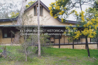
Photograph, Fay Bridge, Birrarung House, 195 Laughing Waters Road, Eltham, 7 September 2013
Laughing Waters Walk, 7 Sep 2013 This Society excursion was a follow up to the Laughing Waters Story told to us by Jane Woollard at our Annual General Meeting in March 2013. It involved a walk commencing from the corner of Laughing Waters and Overbank Roads along Laughing Waters Road to its eastern end and returning partly over the same route - a total distance of about 2.5km. On the way we visited the two artist in residence properties, River Bend and Birrarung, to view the houses on them that are associated with Alistair Knox, Gordon Ford and others in the local mud brick and artistic community. We also able to walk around the derelict ruin which was once home to Gordon and Sue Ford, Boomerang House. An unexpected afternoon tea was offered to us by the artists in residence at Birrarung House and we had a brief opportunity to view inside the house. Birrarung is situated near the end of Laughing Waters Road. It was built in 1974 by Graeme Rose for Gordon Ford who he had asked to build him a small ‘bach’. Builder Peter Jarvis who did his apprenticeship with Alistair Knox for a couple of years recalled there were no drawings. It evolved as more funds became available. Graeme would source second-hand building materials around which he would shape the house. The fireplace was built with chicken wire over which it was rendered with faro cement. A brick floored glass studio, added later, faces a wall of boulders pressed into a manmade cliff, a large pond the link between the rock wall and glass studio. A waterfall, fed by river water, no longer functions. The property became part of the Laughing Waters Artist in Residency Program with the first artist taking up residency in 2001. For a more in-depth description of the property and biographies of the various artists in residence commencing from 2001 through to 2015, see Jane Woollard's book, "Laughing Waters Road; Art, Landscape & Memory in Eltham" published 2016.2013-09-07, activities, artists in residence, eltham district historical society, heritage excursion, laughing waters road, birrarung house, fay bridge collection -
 Eltham District Historical Society Inc
Film - Video (VHS), IMP Productions, The Shire of Etham - The Evergreen Shire (Series 69, Item 4), c.1985
Shire of Eltham Archives: Series 69, Item 4 This video was produced for the Shire of Eltham by IMP Productions and provides a description of the shire, 277 square km on a north/northeast axis, some 25 km northeast of the centre of Melbourne with a population of around 40,000. Scenes include Yarra River, rural settings and urban settings, housing estates, Shillinglaw Cottage, Pigeon Bank at Kangaroo Ground, the Eltham Railway Trestle Bridge with reference to the fight by locals in the 1970s to save it from replacement, Montsalvat, mudbrick making and its use as a building material, the use of mudbrick in the Eltham Community Centre blending harmoniously with the environment. Emphasises people living in the area due to the qualities of life provided. Also the Living and Learning Centre, St Andrews Markets and other local markets, the Eltham Leisure Centre, cricket and horse riding at Eltham Lower Park, the Infant Welfare Centre (part of the Eltham War Memorial), how residents are mindful of protecting their historical heritage, the CBA bank and Allwood House at Hurstbridge, Tracey Naughton about the Eltham "As we are" Community Banner project and the “River of Life banner”, the Parks and Gardens office in the former Police Residence building (now the Local History Centre), Alistair Knox Park, road planning and types of roads, tree canopy, Peck's Dam, green carparks, road drainage, Gordon Ford's garden and natural landscapes, and Were Street shops in Montmorency. Planning for shopping facilities and carparks with a population of 40,000 growing to 55,000, Arthur Street Mall and carpark, local village feel in the shopping centre. Councillors and Council staff featured include Mary Grant, Bob Manuell, Rodney Roschellor, John Cohen, Alan Baker. Also scenes of Commercial Place, Diamond Valley Railway, Eltham Galley, Riverclay and canoeing on the Yarra intermingled with images of the shire from the Shire of Eltham Pioneers Photograph collection.VHS Video cassette Converted to MP4 file format 00:11:56; 79MBshire of eltham, video recording, shire of eltham archives, alistair knox park, allwood house, arthur street, arthur street mall, bob manuell, canoeing, carparks, cba bank, commercial place, council staff, councillors, cr. mary grant, cricket, diamond valley railway, eltham community banner project, eltham community centre, eltham galley, eltham leisure centre, eltham living and learning centre, eltham lower park, eltham railway trestle bridge, eltham war memorial, gordon ford garden, horse riding, housing estates, hurstbridge, infant welfare centre, john cohen, kangaroo ground, local history centre, montmorency, montsalvat, mudbrick, parks and gardens, peck's dam, pigeon bank, police residence, river of life banner, riverclay, road drainage, road planning, rodney roschellor, shillinglaw cottage, shire of eltham pioneers photograph collection, st andrews market, tracey naughton, tree canopy, were street, yarra river, alan baker -
 Eltham District Historical Society Inc
Slide, Maroondah Aqueduct, Research, Victoria, 22 Mar. 1981
An inspection tour of the Maroondah Aqueduct was undertaken by the Shire of Eltham Historical Society on Sunday, March 22nd, 1981, commening where the aqueduct crosses Main Rd., Research, just below Eltham College. The Maroondah Aqueduct was part of Melbourne’s water supply system. It carried water over the 66 km from the Maroondah Reservoir on the Watts River at Healesville to the Preston Reservoir. Of this length, 41 km were open channel, 10 km, tunnel through hills and 15 km in 14 inverted siphons across stream valleys. The route of the aqueduct is north of Tarrawarra and Yarra Glen, along the Yarra escarpment south of Christmas Hills and crossing Watsons Creek into the present Shire of Eltham near Henley Rd. The eastern part of the route lies entirely within the former boundaries of the shire. The aqueduct passes south of Kangaroo Ground to Research and crosses the Diamond Creek by siphon at Allendale Rd., Eltham North. It then extends to Reservoir via St. Helena, Greensborough North and Bundoora. Water first flowed through the aqueduct in February 1891 when it was fed by a diversion weir on the Watts River. Records of the building of the aqueduct indicate that it was a significant construction achievement. The present Maroondah Reservoir was completed in 1927 and the aqueduct was enlarged at that time to take increased flows. About 1971 the section of the aqueduct through and north of Research was replaced by a large pipe and that section of the channel is now unused. The channel has remained largely intact (unlike sections at Greensborough and Bundoora where long lengths of the disused aqueduct have been demolished or filled in). The M.M.B.W. relinquished control of the disused aqueduct reserve which is crown land and the Shire of Eltham took control of this section of the reserve as a linear park. The Maroondah Aqueduct is considered to be an important historic structure, not just to the local area but to the metropolitan area generally. It is considered important to preserve substantially intact long lengths of the disused aqueduct, together with its bridges and other associated structures. 35 mm colour positive transparency (1 of 5) Mount - Agfachrome Agfa CS System black 8 dotsactivities, heritage excursion, maroondah aqueduct, research (vic.), shire of eltham historical society -
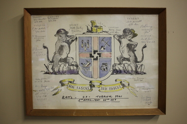 Wangaratta RSL Sub Branch
Work on paper - Coat of Arms, Rats of Tobruk 1941, 1941
Hand drawn Coat of Arms for the soldiers known as the Rats of Tobruk with signatures of those involved in the engagement between 5th April to the 22nd of October 1941 The drawing is signed by artist John DOWIE AM, SX6087 who served with the 2/43rd Battalion Signatories are: VX42389 Eric Hamilton, 2/32 Battalion; VX30189 F.Baldwin, 2/23 Battalion; VX34544, F.J.Mc.Intosh 2/24 Battalion; VX34554 W.Harrison, 2/24 Battalion; WX7281 P.Bone 2/25 Battalion; VX33719 Duke Goldsmith, 2/24 Battalion; VX41179 Harry Frazer, 2/24 Battalion; VX29652 A.R.Stribley, 2/24 Battalion; SX6367 Jack Foley, 2/43 Battalion; VX48340 Harry Jones, 2/23 Battalion; VX42317 Aub Jarrott, 2/24Battalion; VX28869 Rod Deering 2/24Battalion; VX15719 Ian F. Joss 7th Division AASC; VX19723 Len Dauria, 2/12 Field Regiment; NX35852 R.E (Snowy) Cornelius 2/13 Battalion; VX32559 Jim Gray, 2/24Battalion - James Cyril GRAY Born 6/1/1916 in Orroroo South Australia. Enlisted 28/5/1940 at Mildura. Awarded Military Medal for remarkable coolness, bravery and leadership at Tobruk on 24/4 and 1/5/1941. He was promoted to Sergeant on 14/8/1941, Lieutenant in November 1942 then Captain on 9/4/1945. He was wounded in action on 11/9/1943 and discharged on 20/12/1945. He married and had three children. He died on 10/4/1992 aged 76 and buried at Wangaratta Cemetery.This original drawing is by John DOWIE SX6087 who served with the 2/43rd Battalion during the second world war and is signed by the artist and soldiers from the 2/24th Battalion known as "Wangaratta's Own". John Stuart Dowie AM (15 January 1915 – 19 March 2008) was an Australian painter, sculptor and teacher. He was born in the suburb of Prospect in Adelaide, South Australia, and studied architecture at the University of Adelaide. During World War II, Dowie worked in the Military History Unit of the Australian Imperial Force, and as an assistant to Australia's official war sculptor, Lyndon Dadswell. As a soldier, he was one of the Rats of Tobruk. After studying art in London and Florence, Dowie returned to Australia. His work includes over 50 public sculpture commissions, including the "Three Rivers" fountain in Victoria Square, "Alice" in Rymill Park, the "Victor Richardson Gates" at Adelaide Oval and the "Sir Ross & Sir Keith Smith Memorial" at Adelaide Airport. He was made a Member of the Order of Australia in 1981 in recognition of service to the arts as a sculptor and painter. Dowie died on 19 March 2008, aged 93. There is a similiar version of the drawing on page 32 of the book Desert Sand and Jungle Green by Geoffrey Boss-Walker which is an illustrated history of the 2/43rd Battalion.Timber frame containing hand drawn Coat of Arms consisting of "rats" as shield supporters, crest with a swastika in the centre and motto surrounded by signatures.Signatures of artist John Dowie and soldiers engaged at Tobruk. The crest depicts a latrine and the motto reads NON FASCES SED FAECES (Latin translation - "Do not move but the dregs") rats of tobruk, coat of arms, 1941, john dowie -
 Wodonga & District Historical Society Inc
Photograph - Playing Fireman, c1900
This photograph was taken about 1900. Herbert Schlink, on the right of the image was born on 28 March 1883 in Wodonga, Victoria to German migrants Albert Joseph Schlink and Franziska Trudewind. He initially enrolled in Faculty of Arts at the University of Sydney, but after one year he transferred to medicine and graduated in 1907. This marked the beginning of a brilliant career. He was appointed as honorary gynaecological surgeon at Royal Prince Alfred, Sydney NSW from 1922. As a director of the hospital board from 1926, Schlink as chairman (1934-62) supervised the opening of Gloucester House, King George V Memorial Hospital for Mothers and Babies, Queen Mary Nurses' Home, the neurosurgical and psychiatric blocks, the (Sir Earle) Page Chest Pavilion and the hospital chapel. As a gynaecologist, Herbert pioneered the use of cobalt ray therapy in treating pelvic cancer and instigated the systematic follow-up of cancer patients. In 1954, Herbert was created Knight Bachelor for his public services and his service to medicine. He had previously received the Silver Jubilee Medal from his Majesty King George V, and the Coronation Medals of 1937 and 1953. Outside of his medical career, Dr Schlink was an enthusiastic skier. In 1926 he made the first winter crossing from Kiandra to Kosciusko. He was a foundation member of the Kosciusko Alpine Club and was directly responsible for the building of the first chalet at Charlotte Pass. Schlink Pass near Guthega in the Snowy Mountains is also named in his honour. Charlie Ryan is the boy on the left. He was to later become the editor of the Wodonga and Towong Sentinel after the death of his father in 1912.This image is of significant as it depicts a group of local boys including a preeminent medical professional who was born in Wodonga and a newspaper editor.A framed photo of a group of boys playing with a fire cart in Wodonga.Below photograph: "PLAYING FIREMEN / Young Charlie Ryan, left, with the boys of the village./ Herbert Schlink, probably the boy on the right, was to/ become Sir Herbert Schlink, on of the nations most/ distinguished men of medicine. Circa 1900. Photograph courtesy: Wodonga Historical Society"wodonga fire fighters, sir herbert schlink, charles henry ryan -
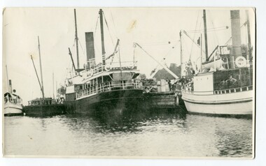 Orbost & District Historical Society
black and white photograph, before 1924
This photograph shows the Lady Harriett, her barge, the Wyrallah and Storm Bird with Captain Jimmy Bills at Harbeck's wharf, Lakes Entrance, The Lady Harriett was a small steamer that serviced the Tambo River and other areas. In 1895 the Lady Harriett was advertised to run between Bairnsdale and Mallacoota on a weekly service. The Lady Harriett and barge did two or three trips up the Tambo per week. She did not carry passengers or run to a timetable and would carry maize and beans as well as fish from Mallacoota where by 1900 the fishing industry was well established' Lady Harriett towed her barge carrying an assortment of goods up the Tambo from 1895 to 1913. The S.S. Wyrallah was a regular Melbourne header for over twenty years. She was run down and sunk by the steamer Dilkera with the loss of six lives at Port Philip Head. (ref. The Argus Friday April 11 1924)This is a pictorial record of a once busy wharf. From Lakes Entrance ocean-going vessels had access to the Gippsland Lakes, the largest navigable inland waterway in Australia.A large black / white photograph of two large ships and two smaller ones at a wharf. There are people on the wharf and on the boats.on back - "Jo-Bull", L-R Lady Harriet.........."lady-harriett s.s.-wyrallah shipping-east-gippsland harbeck's-wharf-lakes-entrance sea-transport -
 Orbost & District Historical Society
black and white photograph, 1918
Tonghi Creek is 66km north - west of Orbost. Prior to the sealing of the Princes Highway west of Orbost, the road surface was anything but good, even by C1917 when cars started to use the road. From Orbost the old road via Marlo to Sydenham was abandoned for the new location which traversed more rugged country via Cabbage Tree, Bell Bird and Club Terrace to Cann River, and the reason for this diversion was on account of settlements being established at Murrungowar and Club Terrace, at which latter place there was a temporary rush to obtain gold. This road was constructed by the Public Works department and a maximum grade of 1 in 19 was adopted, and as speed was not to be catered for the grade followed in and out round the spurs and gullies, resulting in a maze of turns and twists which required a good deal of skill on the part of the horse driver to negotiate." - Bairnsdale Advertiser, Friday, May 2, 1947. (More information from Newsletter February 2010)This item is a pictorial record of roads in the early 20th century in East Gippsland.A large black / white photograph of a bridge over a small creek, surrounded by bush. The photograph is mounted on a thick cream coloured card.on back - "Bridge at Tonghi Creek 1918"tonghi-creek-bridge country-roads-east-gippsland -
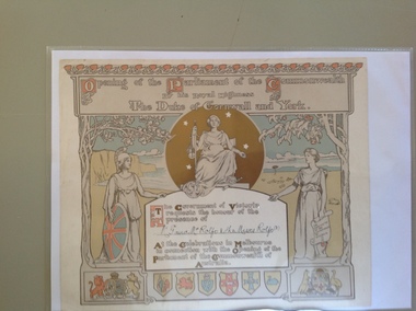 Warrnambool and District Historical Society Inc.
Certificate - Invitation to the opening of the Parliament of the Commonwealth of Australia, 1900
This certificate is an invitation to the opening of the first Parliament of Australia on January 1st 1901 in Melbourne. On this date the six Australian self-governing colonies were federated to become the six states of Australia. The designers of the certificate were Norman Lindsay and John Longstaff. This particular invitation was sent to George Rolfe and his wife and two of his stepdaughters, Annie and Florence. George Rolfe (1836-1919), a tea merchant from Melbourne, began buying blocks of land near the mouth of the Hopkins River in Warrnambool in the 1870s. By the early 1880s Rolfe owned 50 acres in the town, including farming properties and used the buildings near the mouth of the Hopkins as holiday accommodation. He called his property Lyndoch which he improved with the addition of stables, chaff and bone sheds, jetty, boathouse, reservoir, water well and windmill and extensive gardens and he spent most of his later life in this Warrnambool area. Lyndoch today is the site of an aged care facility. This certificate is of considerable importance for two reasons: 1. It is an important memento of a signal event in Australia’s history - the Federation of the States in 1901. 2. The certificate was an invitation to the family of a prominent Warrnambool person – George Rolfe of Lyndoch.This is a piece of thick paper with illustrations and decorations in brown, red, blue, yellow and green tonings. The lettering is in white with coloured capital letters. The images include the shields of the six Australian States, the Coat of Arms of Britain and Australia, outlines of two trees (gum tree and oak tree) and three symbolic female figures representing Justice, Britannia and Australia. The top border decoration represents the waratah flower. The names of the invitees on this certificate have been handwritten in black ink. ‘Opening of the Parliament of the Commonwealth by His Royal Highness The Duke of Cornwall and York’ ‘Mr G and Mrs Rolfe and the Misses Rolfe (2)’ george rolfe of lyndoch, federation of australia, history of warrnambool, george rolfe, opening of first parliament of australia -
 Warrnambool and District Historical Society Inc.
Document, Wollaston sale, 1919
This is a poster advertising the sale of part of the Wollaston Estate in Warrnambool in 1919. The sections for sale were Allotments 1, 18 and 19 which included the Wollaston Homestead. The original Wollaston property of 679 acres was selected by Thomas Manifold in the late 1840s. This land, on the northern side of the Merri River, near the Woodford Road was three kilometres from the Warrnambool town. The first farmer we know who leased the property was William Simpson. Walter Manifold inherited the property and he took it over in 1884. The swing bridge he built in 1890 still stands today. In 1919 the Closer Settlement Board of Victoria acquired Wollaston and 17 lots were sold to returned soldiers for farming purposes. By 1930 there were only five soldier settlers remaining. In 2009 further subdivision took place with lots sold for residential purposes. The homestead allotments were sold separately in 1919 with various owners of the homestead itself recorded since that time. This poster is of interest as it shows the areas of the Wollaston Estate which were sold in 1919. The history of this estate is well-documented and of importance in the history of Warrnambool. This is a sheet of paper with red and black printing and a map of the Wollaston Estate which is photo-lithographed. The sheet has been folded three times. It has some small tears at the top of the page. wollaston, history of warrnambool, walter manifold -
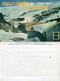 Kiewa Valley Historical Society
Souvenir Postcard Folder – Falls Creek Ski Village
After World War II, the Kiewa Hydroelectric Scheme was started in the Kiewa River valley by the State Electricity Commission of Victoria. On land previously used only for summer cattle grazing in the natural alpine grasslands, the first ski lodge was built in 1948 by workers from the scheme. The first lift, a rope tow, was built in 1951 and the first chairlift in Australia was constructed there in 1957. Falls Creek Post Office opened on 9 June 1958 (with telegraph and telephone facilities only until 1964) .Despite strong opposition from the head of the Kiewa scheme, who didn't want tourists clogging up his roads and destroying his "dry" construction camps by bringing in booze, Falls Creek boomed as much as Hotham, partly owing to its relatively good access road. Early lodges included Bogong (c.1946), Skyline (1947), Albury (1949), Myrtleford (1949) and Dawn (c.1950).The souvenir postcard photographed and produced by an enterprising local businessman Mr S K Pearce, was produced as a memento for skiers and other visitors to the Falls Creek and Mt Beauty area to send to family and friends as a reminder of their visit to the region, or to keep as a personal souvenir. It presented an excellent promotional opportunity for enterprising local businessmen to promote the area to skiers and tourists near and far. It also presents an excellent pictorial history of the falls creek area around the late 1950’s to early 1960’sColour postcard folder (unused) containing 13 photographs of the Falls Creek ski area and surrounds. Inside cover has a brief description of the area and the services available to visitors Printed on front cover- FALLS CREEK SKI VILLAGE. Your Souvenir Folder Photo of skiing slopes of the village Inside front flap - a brief description of the Falls Creek area and the services available to visitors 1. Diana Lodge parking area and Spion Kopje 2. Winterhaven Lodge 3. Ski Hirage Centre and skiing slopes 4. Ski Lodges from main road 5. Nelse and Arundel Lodges 6. Day visitors’ shelter and parking area 7. Summit T-Bar lift 8. Spur T-bar looking towards Village and Spion Kopje 9. T-bar lower station and Snow Crystal Inn 10. ‘Akja’ rescue sled in use 11. Falls Creek road and Grand Coeur Lodge annex 12. Rope tows and beginner slopes 13. Back cover- Published by Nucolorvue Pty Ltd Mentone Vic. Printed in Australia For S.K.Pearce Pty Ltd Tawonga and Mt Beauty falls creek, snow, bogong high plains, victorian alps -
 Kiewa Valley Historical Society
Four photographs of the Blue Duck Hotel and two Photos of the Glen Wills area, c1920 Post cards, c1949/50 small photographs
The Blue Duck Hotel stands at the confluence of 3 trout rivers - Cobungra, Bundarra and Mitta Mitta, called Angler's Rest. The original 1900's building was of slab construction and operated as a butcher shop, servicing miners on the track from Omeo to Mt. Wills. In 1912 it was purchased by a miner, Billy O'Connell, and he obtained a hotel license. In the early 1920's he transported 2 houses from Omeo on Horse drays. One is the main building of the Blue Duck and the other was a residence where Billy and his wife raised their nine children. The small log structure behind the pub is State School No.4286 where the children attended school. A teacher was shared with Glen Wills. By the late 1920's the hotel was discovered and patronized by keen anglers. Sir Harold Clapp (head of the railways) was one and he had the bronze blue duck cast and presented to the owners in the 1930's. This stands at the entrance to the premises.These photographs are of a building, in a remote area, that has provided a service to miners, anglers and travellers for over 100 years and continues to do so today. It also played a vital role in the history of the Mt. Wills/Omeo gold mining days.3 Post cards, Black and White photographs. 3 small black and white photographsPost Card No. 1 - "Blue Duck Hotel- Omeo-Glen wills road Ray Love Series No.2"(written on lower front) Post Card No. 2- "Looking towards Bogong High Plains. Omeo-Glen Wills road"(front, bottom, L hand) Ray Love Series No. 18 (front, lower R hand corner) On both of above photos, centre back, is stamped POST CARD and underneath this is printed "A GENUINE PHOTOGRAPH'/ Post Card No. 3 - Bottom L hand corner "Mystic Sea Australian Alps". R hand corner "(Bulmer Copyright)". Each small photograph, handwritten on back "Blue duck Hotel". All have circular stamp with "Print by Wilson White Albury" blue duck hotel; anglers rest; omeo highway; fishing; mining -
 Warrnambool and District Historical Society Inc.
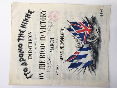
Leisure object - Sheet music, On the road to victory, 1941
This piece of music has been produced during World War Two (1941) as a propaganda and fund-raising piece for the people of Alexandria in Egypt. It has both Greek and British backing with the headings on the cover in both languages. The music is a march and the title suggests that victory is on the way so the emotions are being stirred to keep up the morale. Egypt in World War Two was still under British influence and Alexandria is a port in Egypt at the mouth of the Nile River. In 1941 British battleships were based in the Alexandria harbor and two of them were disabled by Italian Navy divers. Hence it is not clear why it was the Hellenic (Greek) Red Cross raising funds for Alexandria through the sale of this music which was produced in that city by the Moharrem Press (founded 1938) and composed by Lena Bonfiliou, probably a Greek person. It is not known if this piece of music was bought in Australia or brought back to Australia by an Australian military person during World War Two.This is an interesting piece of music. Its connection to Warrnambool is not known but it is an example of the type of music produced during World War Two to help the war effort. This is a four page piece of music, ‘On the Road to Victory’ (a march) with a front cover, a blank end page and two pages of musical notation. The latter pages have black printing on white pages. The front cover has both Greek and English printing and a colour image of four British and Greek flags resting on a gun carriage with armaments underneath and indications of an explosion. There is a red stamp on the cover (Hellenic Red Cross). The pages are in good condition. English printing: ‘On the Road to Victory, March, P12’ Stamp: ‘For the Hellenic Red Cross, Alexandria’ alexandria, hellenic red cross, warrnambool, on the road to victory music -
 Warrnambool and District Historical Society Inc.
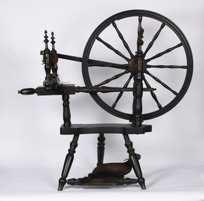
Functional object - Spinning Wheel, early 19th century
This spinning wheel was recovered in pieces from N.S.W. and re-assembled in the 1980s by Les O'Callaghan, a Warrnambool historian and President of the Warrnambool and District Historical Society for many years. The spinning wheel is believed to have belonged to Alice Allan (nee Mullaly) who married William Osborne Allan in 1844. They had three sons. William Allan was a pioneer settler who, in 1839/40, established, with his brothers, a property (Allandale) east of the Hopkins River in the area known today as Allansford. During the 1840s the property was divided with William taking up the Allandale section and his brother John taking the Tooram section. William died in 1860 and Alice continued to manage the property with the assistance of her sons until her death in 1887 when the Allandale estate was sub-divided. A spinning wheel such as this would have been an important item in a pioneer settler's home with the wife needing to spin wool or sometimes flax to produce cloth for clothing and furnishings. This spinning wheel is of considerable significance as it is believed to have belonged to Alice Allan, a pioneer settler in the Warrnambool district. This would make it one of the oldest and most interesting items in our collection.This is a spinning wheel made of metal and wood. The base stand has a foot pedal attached to the wheel and other sections of the spinning mechanism abovealice allan of allandale, william osborne allan of allandale, vintage household items, les o'callaghan warrnambool historian -
 Mission to Seafarers Victoria
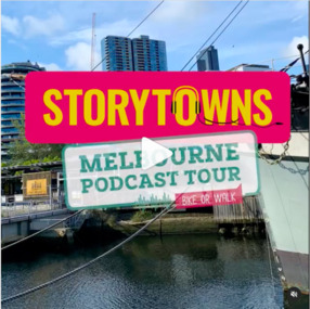
Document - Media release, Podcast reveals unique Melbourne experiences, April 2022
In April 2022, the City of Melbourne partnering Storytown, with launched the "Melbourne Podcast Tour". Storytown, an application created by Jarrod Pickford offering audio guides. This self-guided tour takes you along the Yarra River, from Southbank to Docklands, taking around 1.5 hours to complete by bike or 2 hours by foot. From their website: "Told by locals Discover Australia through the voices of its locals! Storytowns collaborates with communities to craft immersive audio guides, offering authentic travel tales from the heart of each neighborhood. Simply grab your headphones, download our app and explore Melbourne’s suburbs with with our fresh-out-the-oven “Railway Stories” audio guides! And if you’re feeling adventurous this weekend, take a road trip through regional Australia and let us jazz up your adventure, where the local folks are the true stars of the story. Sue Dight was interviewed to add to tThe interview was a to way to put the Mission to Seafarers on the map and increase its visitation. Unfortunately the tour is not avalaible anymore (as from 2023).Digital copy of a media releasecom, city of melbourne, app, storytown, sue dight, on the map, marketing, audioguide, jarrod pickford, audio guides, self-guides tour, podcast, radio interview -
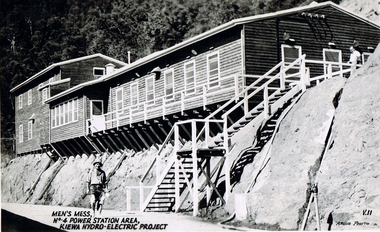 Kiewa Valley Historical Society
Postcard Circa 1950, Men's Mess No.4 Power Station, Kiewa Hydro-Electric Project
This postcard was produced in the 1950's for the tourist trade in the Kiewa Valley and Alpine region. It encompasses the period when the State of Victoria was pressured by the ever increasing demand by industry and its population for electricity supplies. Hydro electricity was seen as an untapped natural resource to quench this demand. The Victorian Alps and the rivers flowing into its valleys was ideal for the construction of the Kiewa Hydro Electricity Scheme. The late 1940's saw the development of this scheme and the changing of sections of alpine landscape is covered by this and other postcards/pictures (tourists, construction workers, and established rural populations). This period in time was before the established wildlife and forest/nature groups became political activist who changed legislative acts to protect the environment.Although this photo details the eating facilities of the construction workers at the power station it was not only a postcard for the people employed in the Hydro Scheme is was also provided to tourists visiting the area and thus used for promotional purposes.This rural region (Kiewa Valley/alpine plains) was at most only significant to a smaller group of winter sports, summer hikers/horse riders and rural farmers/graziers. The numbers of tourists and the increase in the local resident population was boosted by the construction of the Hydro Electricity Scheme. This influx to the regional population resulted in a corresponding diversity in services and brought about an environment that responded to a growing level of tourists and thereby permitting this industry to grow more rapidly than it would have naturally. This postcard details an attraction to the "cleaner" method of providing electricity. This postcard was purchased in 1950 by a surveyor at Landford's Gap. The men shown in this photograph would have been employed by the S.E.C. under the Kiewa Hydro-Electricity Scheme.This item is a scanned black and white photograph of a construction worker walking from stairs leading down from the men's mess building, in 1950. See 0480 (A) -(C), (E) - (F) for other photos of similar postcards"MEN'S MESS No.4 POWER STATION AREA, KIEWA HYDRO-ELECTRIC PROJECT" "ARGUS PHOTO V.IIkiewa valley tourism, victorian alps, alternate energy supplies, alpine population growth, secv -
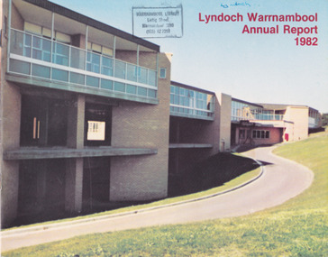 Warrnambool and District Historical Society Inc.
Document - Lyndoch Warrnambool 1982 Annual Report
This is the 1982 Annual Report for Lyndoch Home and Hospital for the Aged, Warrnambool. It contains lists of Board Members, a President’s Report, Lyndoch’s Aims, financial reports, photographs and a list of Life Governors. Lyndoch Home for the Aged was established in 1952 and has developed with a wide range of facilities for the aged since that date. The original Lyndoch property near the mouth of the Hopkins River was owned by a Melbourne tea merchant, George Rolfe, who bought the land when there were on the site only a couple of cottages and a larger building which had been a school, Warrnambool Grammar, run by Henry Kemmis. Rolfe acquired the land in the 1870s and named the property Lyndoch after the town in the Barossa Valley where he had lived. He owned Lyndoch for 44 years and it was his stepdaughter, Florence Lake who built in the 1920s the bungalow known as Lyndoch which forms the original building of the Lyndoch Home for the Aged, Today the facility is called Lyndoch Living. This 1982 report is kept for the benefit of researchers wanting details of the history of Lyndoch over the past 30 or 40 years. This is a booklet with a plasticized cover with a white back and a multi-coloured front cover. The front cover has a photograph of a Lyndoch building. There are six double-sided pages with printed material and photographs on white paper and a yellow and orange strip across the top of the pages. The pages are stapled.On front cover: Lyndoch Warrnambool Annual Report 1982 Stamp of Warrnambool Library On back cover: A red circle with the words ‘Lyndoch, Comfort and Security for Aged Folk’ lyndoch aged care facility, warrnambool, lyndoch warrnambool -
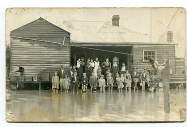 Orbost & District Historical Society
black and white photograph, poss. 1920
In the photograph are the Rice family, Billy Nixon' family and Charlie Johnston. William Nixon, son of James Nixon and Alice (Roberts) Nixon was married to Ilma Muriel (Cadwallader) Nixon on 2 Apr 1902 in Orbost. They had six children - Llewella Adele (Nixon) King, Sydney William Columbo Nixon, Arthur Harry Nixon, Jack Warton Nixon, Claudine Frances (Nixon) Taylor and Daphne Joyce (Nixon) Menz Damage estimated at £500,000 was caused by the 1934 floods in the Orbost district. This 1934 flood was devastating, destroying a section of the 1922 Orbost bridge, wrecking fences, bridges and roads, dumping silt and debris on the rich river flats and drowning cattle. Note: although this card has the date 1934 written onto the rear, the flood incident depicted most likely dates from 1920 (ref. Weekly Times, Saturday 6 March 1920 p 41 when this photo was printed).This item is a pictorial record of a flood in 1920 (ref. Weekly Times, Saturday 6 March 1920 p41). Snowy River flood are a feature of the Orbost area. These floods cover the rich agricultural land. A black / white photograph / postcard of a group of people standing in floodwaters outside a timber building. Included are young children and babies being held by women. Two boys are holding dogs in front of them.on back - "Billy Nixon's house (now Downys 1991)"orbost - floods - nixon - 1920 -
 Marysville & District Historical Society
Flyer (item) - Information Flyer, Forests Commission, Victoria, Cumberland Scenic Reserve, 1918-1983
An information flyer that was produced as a guide to the Cumberland Scenic Reserve by the Forests Commission of Victoria. The Forests Commission Victoria (FCV) was the main government authority responsible for management and protection of State forests in Victoria, Australia between 1918 and 1983. The Commission was responsible for ″forest policy, prevention and suppression of bushfires, issuing leases and licences, planting and thinning of forests, the development of plantations, reforestation, nurseries, forestry education, the development of commercial timber harvesting and marketing of produce, building and maintaining forest roads, provision of recreation facilities, protection of water, soils and wildlife, forest research and making recommendations on the acquisition or alienation of land for forest purposes″. The Cumberland Scenic Reserve is set in the heart of the mountain forests of Victoria and is 16km east of Marysville on the Cumberland Road. This reserve forms part of the catchment of Armstrong Creek, a tributary of the Yarra River which provides water for the Melbourne area. The reserve is a prime mountain ash area in which is set the old Cambarville sawmill and village site.An information flyer that was produced as a guide to the Cumberland Scenic Reserve by the Forests Commission of Victoria. 423Aforests commission victoria, cumberland scenic reserve, marysville, victoria, cambarville, the big tree, cora-lyn falls, barton's lookout, cumberland falls, sovereign view, armstrong creek, yarra river, mountain ash