Showing 10847 items
matching maps
-
 Bendigo Historical Society Inc.
Map - HAWKESTONE : COUNTY OF BENDIGO, 7-11-15
Map. Hawkestone, County of Bendigo, County of Talbot, Lyell, Sutton Grange, Redcastle, Elphinstone, Metcalfe, Coliban River, Myrtle Creek. Albert J. Mullett, Government Printer, Melbourne. Photo-Lithographed at the Department of Lands and Survey, Melbourne by W.J. Butson,7-11-15. Price 1/-. (number 111 in map cupboard 1)Albert J. Mullett, Government Printer, Melbourne.map, bendigo, hawkestone. -
Bendigo Historical Society Inc.
Map - MUSKERRY : COUNTY OF BENDIGO, 1962
Map. Muskerry, County of Bendigo, County of Rodney, Goornong, Ellesmere, Axedale, Weston, Crosbie, Toolleen, Campaspe, Forest or Mannering Creek, Back Creek, Campaspe River. By authority A.C. Brooks, Government Printer, Melbourne. Drawn and reproduced at the Department of Lands and Survey, Melbourne, 1962. Price 2/-. (number 110 in map cupboard 1)A.C. Brooks, Government Printer, Melbourne.map, bendigo, muskerry -
 Bendigo Historical Society Inc.
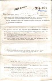
Document - MCCOLL, RANKIN AND STANISTREET COLLECTION: BENDIGO EXTENDED GOLD MINING COMPANY N/L MINING LEASE, 13 November 1956
Document: Bendigo Extended Gold Mining Company gold mining lease. 4 page document with attached map. Map shows area running roughly parallel to Adam Street, Quarry Hill. Lease between Bendigo Extended Gild Mining Co. N/L and State of Victoria. No. 11328, Vol 334 Fol 047.organization, mining, gold mining lease, bendigo extended gold mining co n/l; gold mining lease -
 Ballarat Tramway Museum
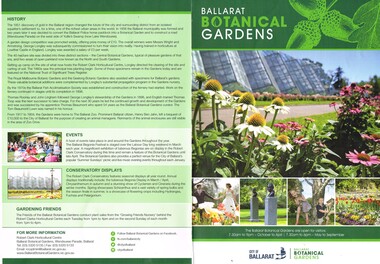
Pamphlet, City of Ballarat, "Ballarat Botanical Gardens", 2016
Pamphlet - A3 folded to A4 full colour titled "Ballarat Botanical Gardens", giving an overview of the Gardens area, history, events, conservatory displays and contact details. Includes a map of the Gardens from Carlton St to St Aidans Drive, locations and notable features. Map shows the revised layout at Depot Junction and Wendouree Parade.trams, tramways, gardens, botanical gardens, btm, wendouree parade -
 Bendigo Historical Society Inc.
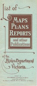
Document - LIST OF MAPS, PLANS, REPORTS PUBLISHED BY MINES DEPARTMENT VICTORIA 1938
Blue booklet, on front ' List of Maps, Plans, Reports and other publications of the Mines Department of Victoria. Issued by Geo Brown Secretary for Mines under the authority of The Hon. E.J. Hogan, MLA, Minister of Mines. Booklet contains list of publications of geological reports, maps etc for Ararat, Ballarat, Beechworth, Bendigo, Castlemaine, Gippsland, Maryborough.Geo Brown, Secretary for Mines under the authority of The Hon.E.J. Hogan, M.L.A. Minister of Mines.organisation, government, geological maps list -
Bendigo Historical Society Inc.
Map - BENDIGO, GREATER CITY OF, 2013
Map, City of Greater Bendigo, Epsom/Huntly, Heathcote, Strathfieldsaye/ Junortoun, Mandurang, Sebastian, Mia Mia, Maiden Gully, Ravenswoon, Axedale, Myers Flat, Redesdale, September 2013, on front. Lockwood South, Marong, Raywood, Neilborough, Elmore, Goornong, on reverse side. ( number 413 in Map Cupboard 1 ). Donated by Bendigo Council.bendigo, hospital -
Clunes Museum
Pamphlet, Clunes Historic Gold Town Victoria
.1 Foolscap brochure folded in 4, coloured and black and white photos of Clunes. Text outlines the history of Clunes and depicts points of interest with map of area on back. .2 Foolscap brochure folded in 4, coloured and black and white photos of Clunes. Text outlines the history of Clunes and depicts points of interest with map of area on back.clunes gold town, clunes attractions, clunes history -
Eltham District Historical Society Inc
Folder, Thomas Bibbs
Some comments/observations of the district based on a photo map of the County of Evelyn which was published 1866, compiled 1855 by Thomas Bibbs. A4 photocopy of notesthomas bibbs, tommy's hut, parish of nillumbik, michael callanan, map, kinglake, kangaroo ground, arthurs creek, carden, county of evelyn, haley's preemptive right, isabella donaldson, j. mason, james donaldson -
Tatura Irrigation & Wartime Camps Museum
Document - Book, H M Rehabilitation Centre Dhurringile: A Conservation Analysis, 1995
A comprehensive book on the life of Dhurringile Mansion from 1800's to late 1900's. Includes maps showing the layout of the Mansion.Printed pages held together with a multiring binder of black plastic. Front cover is clear, back cover is black. Title and black and white photograph of Dhurringile in a square on front.dhurringile mansion, h m rehabilitation centre, winter irving family -
University of Melbourne, Burnley Campus Archives
Plan - Coloured plan, Plan of Burnley Gardens, 1929?
Layout of gardens, farm buildings, orchard, etc. overlaid on part of Lands Department map. See paper catalogue for full descriptionPart of larger plan (Lands Department Parish Plan). Partly hand-drawn. Area bounded by Yarra River, Swan St, Glen Iris railway line. Shows Burnley Gardens layout, handwritten amendments and explanation of existing and proposed structures including: Pavilion, sketch of unbuilt Administrative Building, poultry yard, contours of old orchard, sketch for Plant Research Institute, ditch, silo, milking shed, laying pens. See aboveburnley gardens, pavilion, burnley school of horticulture, farm buildings, poultry -
 Buninyong Visitor Information Centre
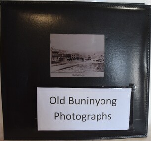
Album - Photograph Album, Old Buninyong Photographs (Early Buninyong)
The album was compiled by Derek Leather using photographic reproductions of images of Buninyong. The album includes early maps, streetscapes, monuments and buildings.Significant images of nineteenth century Buninyong streetscapes.Black, hard-covered album with thirty-two fixed photographs and five lose photographs. Compiled by Derek Leather, former Shire of Buninyong councillor. Old Buninyong Photographsbuninyong, derek leather, streetscapes -
 Flagstaff Hill Maritime Museum and Village
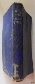
Book - Technical Reference, James Tait, Extra Master and Author et al, Tait's Home Trade Guide to the Board of Trade Examinations for Mates and Masters, 1943
The book includes navigational information, tables and maps, diagrams and formulas. It was written for Examiners and Students studying for their nautical Mates and Masters marine qualifications— notes have been handwritten inside the front and back covers. Notes in point form: 1. I have seen the back of a torpedo EBoat or UBoat in my starboard side 2. I _ _ _ to - - - - - - - - - Port side 3. at a distance ----------- 4. Enemy surface vessel in sight __________ 5. suspicious vessel in sight 6. enemy (undecipherable) 7. I have cut a _ _ _ adrift with my _ _ 8. FI_ _ WISE _ _ _ 9. STARWISE 0. OPEN FIREThis relatively rare book provided up-to-date navigational information during World War II. It was to be used by Examiners to assess whether students qualified to be a Ship's Mate or Ship's Master. The contents of the book were based on maritime knowledge gained over centuries. It is an aid to understanding the navigational methods of the time and the changes and improvements in more recent history.Title: Tait's Home Trade Guide: to the Board of Trade Examinations for Mates and Masters Author: James Tait, Extra Master Publisher: Brown, Son and Ferguson, Ltd. Glasgow, Great Britain Date: Revised Edition 1943 Further Information: Fourteenth Edition 1941, Reprinted Edition 1943. Revised and brought up to date by Captain H. T. Jefferys, Extra Master Printed by Nautical Press, Brown, Son & Ferguson, Limited, 52-58 Darnley Street, Glasgow Hardcover, small book, royal blue cover, silver embossed text on spine. Textbook for Mariners. Includes tables and maps, diagrams and formulas, and navigational information. The inside covers of this book contain handwritten calculations, diagrams and notes that refer to navigation. Notes inside the back cover refer to an enemy vessel and OPEN FIRE.Spint, in silver embossing "TAIT'S HOME TRADE GUIDE" Handwritten inside the back cover "R.A.D. / MOORE / PT. WELCH" Included with the text inside the back cover "Gascoyne" "506" and "RCM"flagstaff hill, warrnambool, shipwrecked coast, flagstaff hill maritime museum, maritime museum, shipwreck coast, flagstaff hill maritime village, great ocean road, james tait, nautical text book, navigational text book, examination text book, brown, son and ferguson limited, 1943 nautical text book, world war ii text book, wwii text book, torpedo, open fire, pt welch, vessel gascoyne, e-boat, u-boat, marine technology, world war ii, wwii, ww2, navigation exams, ship's mate, ship's master -
 Ringwood and District Historical Society
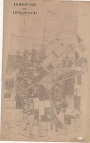
Map, Borough of Ringwood, Victoria - c.1950s
A0-size (approx) linen-backed municipal engineer’s survey map of named streets and lot-numbered properties within Borough of Ringwood.Scale: 8 chains to 1 inch. -
 Ringwood and District Historical Society
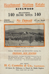
Flyer, Land Sale Brochure, Heathmont Station Estate, Ringwood, Vic. - circa 1925
Extract of "Herald" 2/2/22: The intention of the Railway Commissioners is to electrify the line to the Gully as soon as convenient, and with greater frequency of service many persons settled, and settling, in the district will be benefited. There is a scheme which may be launched that will allow for an express service of fast trains to the Gully. The commissioners are alive to the necessity for assisting to settle the picturesque districts between Box Hill and Gembrook.Bi-fold advertisement for sale of retail and residential sites, including panoramic and other photographs, map, and summary of subdivision features and local facilities. Subdivision includes Canterbury Road, Station Street (later Wainui Avenue), Lisgoold Street, Viviani Crescent, and Balfour Avenue. Agent - H.C. Costello & Co., Auctioneer, 128 Queen Street, Melbourne, or Church Street, Middle Brighton. Phones: Central 10517 and X1205. -
 Kiewa Valley Historical Society
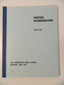
Report - Alpine Area Proposed Recommendations, Land Conservation Council, Victoria Melbourne, April 1978, April 1978
The Land Conservation Council was established by the Land Conservation Act 1970. It makes recommendations to the Minister for Conservation with respect to the use of public land. Notices showing the boundary of the study area ... published in the Victorian Government Gazette Sept. 1973. A descriptive report was published in July 1977. Submissions (1538) on the future use of public land were received & included those representing a wide cross-section of the community. These were considered in the final report.Of interest for research on the changing ideas regarding the use of public land and the environment.Blue book bound by dark blue cloth tape. It has 92 pages with maps at the end and an empty folder inside the back cover.alpine area, land conservation council, alpine study area report -
 Kiewa Valley Historical Society
Memoir - Adrian Rufenacht, The Kiewa Project
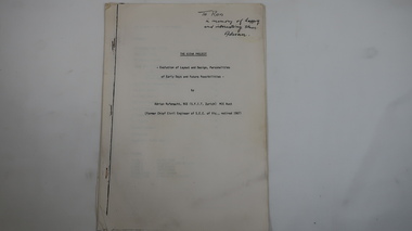
Adrian Rufenacht, BCE (S.F.I.T. Zurich) MIE Aust. former Chief Civil Engineer of the State Electricity Commission of Victoria, retired 1967. Insight into the Kiewa Hydro Electric Scheme.First hand knowledge of the history of the Kewa Hydro Electric Scheme.40 pages stapled with 4 staples. The Kiewa Hydro Electric Scheme by Adrian Rufenacht, former civil engineer of SECV. Includes maps.On the front page - handwritten: 'To Ron / in memory of happy / and interesting times. / Adrianadrian rufenacht, khes, kiewa project, construction, secv -
 Eltham District Historical Society Inc
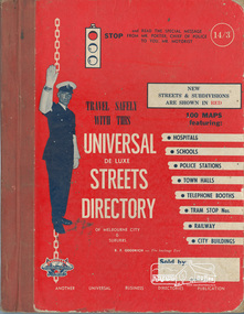
Book, Universal Business Directories (Aust.) Pty. Ltd, Universal De Luxe Streets Directory of Melbourne & Suburbs; Sixth Edition, 1960, 1960
Hardback; xiv; 70 pages; 97 colour maps; 12 pages advertising including message on Road Safety by Chief Commissioner of Police Inside cover "Fhin McPhee Whittlesea"melbourne maps -
 Bendigo Military Museum
Plaque - PLAQUE, VIETNAM VETERANS ASSOCIATION
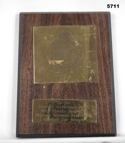
Plaque - wood with gold metal engraved. On metal is a map of Vietnam, the Rising Sun Badge, Australia Flag, Aeroplane, Kings Crown in the centre."To the Bendigo Service Club with thanks from the Vietnam Veterans Association, Bendigo Sub Branch".plaque, vietnam veterans -
 Lara RSL Sub Branch
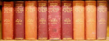
Book, Official History of Australia in the War of 1914-18 - Volume VI - The AIF in France 1918 Author C.E.W. Bean. The AIF in France May 1918- the Armistice, Published 1942
This volume deals with those months in which the first World War turned against the German Army on the western front, and shows in detail how, in the crucial Amiens sector that change was brought about. The completion of the story of the final offensive in 1918.An account of the conclusion of the first world war with Germany being defeated and surrendering.Official History of Australia in the War of 1914-18 - Volume VI - The AIF in France 1918. Hardcover cardboard. Maps, diagrams, illustrations, chronologygerman surrender, battle of aisne 1918, monash succeeds, battle of hamel, amiens, armistice, peace treaty signed, battle of montbrehain -
 Shepparton RSL Sub Branch
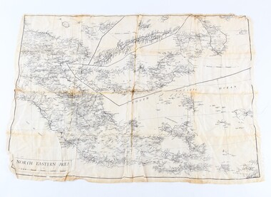
Silk escape map
Used by Allied troops in the Pacific in ww2Silk escape map of Northeastern Area of Papua and New Britain. Black printing on white silk. SCALE 94 mm to 50 miles.Northeastern Area escape map -
 Bendigo Military Museum
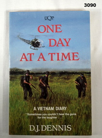
Book - BOOK, VIETNAM, D J Dennis, One Day at a Time, 1992
One Day at a Time is the story of one day at war based on interviews and the author's own diary involving service in Vietnam.Soft card cover. Title in red print. Front cover illustrated with a colour drawing. 161 pages with black & white photos / map.books-military-history, vietnam -
 Bendigo Military Museum
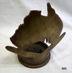
Memorabilia - TRENCH ART, 1941
Brass map of Australia on top of a brass boomerang, which is attached to a brass 6 pdr. shell case on the outside circular base of the casing."AUSTRALIA" on side of casing. On shell base: 6 Pr 10 cwt 11, LOT 197, RL kn 1941 CFornaments, military history, trench art -
 Bendigo Military Museum
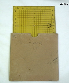
Equipment - PROTRACTOR, SQUARE, C.1939 -45
Belonged to Thomas Henry ISER No V24933 and VX102660 2nd AIF. Refer Cat No 383.2 for his service history..1) 360 deg Protractor labelled as "Direction finder" Used for map navigation planning,yellow plastic. .2) Cardboard sleeve for .1).marked "T. ISER"navigation, protractor, military, equipment -
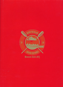 Mission to Seafarers Victoria
Book, Mission to Seafarers, Round the Island- Around the World - Mission RASI 2015, 2015
"In connection with the SG50 celebrations in Singapore, Mission RASI (Row Around Singapore Island) will see a team of Singaporeans join hands with friends from overseas in a test of endurance and teamwork, to raise funds to further the Mission's work in promoting good shipping practices and a safe working environment for seafarers"--Page 4.Red cardboard hard cover book with red paper outer sleeve. 55 pages : color illustrations, color map ; 31 cmnon-fiction"In connection with the SG50 celebrations in Singapore, Mission RASI (Row Around Singapore Island) will see a team of Singaporeans join hands with friends from overseas in a test of endurance and teamwork, to raise funds to further the Mission's work in promoting good shipping practices and a safe working environment for seafarers"--Page 4.mission to seafarers, worldwide, charity, volunteers, singapore, nigel porteous, andrea fleming, london, rasi, row around singapore island, 2015, fundraising, reverend andrew wright, mts london, mts singapore, rowing -
Glenelg Shire Council Cultural Collection
Flyer - Flyer - Princess Margaret Rose Caves, c. 2009
Princess Margaret Rose Cave 'flyer'. Light card, photo of cave formations on front, information about region, plus map, on reverse.advertising, tourism, travel -
 Geelong RSL Sub Branch
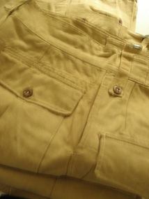
Uniform Trousers - Tropical, There are no makers marks, Mid 20th Century
Tropical Dress Trousers for use by members of the AIF posted to 'Desert' Conditions.These uniforms were issued during WW2 to members of the AIF.Khaki colour trousers, cotton material, metal belt buckels x 2. One pair of the trousers has large map pockets.Pair 1 - V54 1945 Made in Australia, Size 35, hand written in ink on right hand inside pocket 2832. Pair 2 - Q7 1943 Made in Australia, Size 30, there is a tag for Regimental No and Name.aif, khaki, trousers tropical, ww2 -
 Geelong RSL Sub Branch
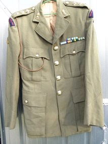
Uniform Jacket, Service Dress Jacket RNZ Artillery, Circa 1950's
The Jacket would have been made circa 1950's and belonged to a member of the RNZ Artillery.This Jacket belonged to a Captain of the RNZ Artillery.Khaki Service Dress Jacket, pure wool Garbardine, two pleated breast pockets, two pleated map pockets, synthetic lining.Captains badge of Rank, all buttons RNZA, lapel Badges RNZA, Shoulder Patches blue with red writing Royal New Zealand Artillery, on the right sleeve Black Colour Patch and a Parachute Patch. There are six ribbons of decorations above the left breast pocket. There is a fine leather plaited lanyard - light brown - through the right epaulette and the end placed in the right breast pocket.rnz artillery, captain -
Glenelg Shire Council Cultural Collection
Document - Flyer - Promotional material for Portland Victoria, n.d
DL flyer, bi-fold, advertising Portland as a place for industrialists to invest in. Textured paper, full colour photographs of Portland and location map.portland industry -
 Greensborough Historical Society
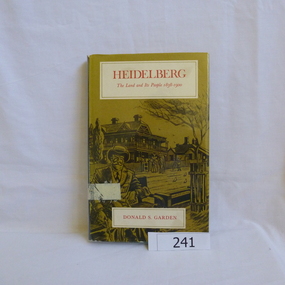
Book, Melbourne University Press, Heidelberg: the land and its people 1838-1900; by Donald P. Garden, 1838-1900
This book covers the early history of Heidelberg, Victoria from its beginnings in 1838 to 1900.There is some reference to the 'annexation' of Greensborough in 1875 and the route of the Heidelberg-Eltham railway line, 1893.Hard cover book. 218 p., ill., maps. Slip cover has a drawing based on an early photograph of the Old England Hotel.Property stamps from Nunawading Public Library (cancelled from their collection)heidelberg, greensborough, donald garden -
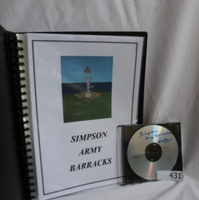 Greensborough Historical Society
Folder and compact disc, Simpson Army Barracks, 2011_
This document is the result of research into the history of Watsonia Barracks (now Simpson Barracks) by GHS member Marilyn Smith. It details the origin of street names in the surrounding area and includes biographical information on those after whom the streets were named. Updated December 2016.The Watsonia Barracks has been in use since WW2 and is today home to the Defence Force School of Signals. It was built on the property formerly owned by Ainslie Meares. In 1951, surrounding land was purchased for the extension of the barracks. The suburb of Yallambie was formerly part of the Barracks. Black spiral bound folder (approx. 32 pages) with accompanying compact disc. Colour illustrations and maps. Updated 2016 in Word document.simpson army barracks, watsonia barracks, yallambie, marilyn smith, watsonia