Showing 10876 items
matching land
-
 Port Fairy Historical Society Museum and Archives
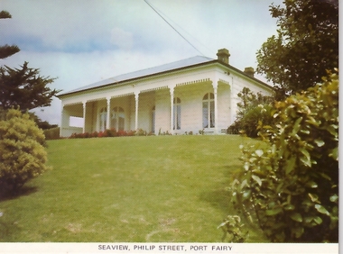
Postcard, Seaview Philip Street Port Fairy
The construction of Seaview commenced in 1860, after David Talbot, purchased the land from James Atkinson,It had been suggested that it was intended to be double storied but there is no evidence of how that would have been accomplished. Following Talbot’s insolvency, Michael O’Reilly leased the house in 1862 until 1876 when he left for Melbourne.William Powling (Solicitor) acquired the house for Eight hundred and twenty three pounds in 1890 and lived there the rest of his life. His son Ernest Powling continued living there before selling it to Matthew Cathcart in 1917.Coloured photograph of Front of Seaview showing bay window and verandahsouvenir, port-fairy, seaview, philip street, house -
 Port Fairy Historical Society Museum and Archives
Photograph
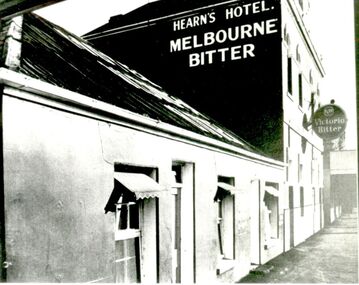
Tennysons Hotel Sackville Street Port Fairy Patrick Tennyson leased the Farmers Inn in 1882 and applied to change the name to Tennysons Hotel. In 1885 he bought the freehold in the Great Land Sale for 780 pounds.12 shillings and 8 pence and then carried out extensive renovations. The double storied addition was added in 1893. The hotel continued under various licensees until it burned down in 1977 under the name "Fishermen's Arms". This photograph was taken during the licencee W J Wright; the single story was the Farmers InnBlack and white photograph of facade of Hearn’s hotel with two advertising signs for beerhotel, sackville street, tennysons hotel, farmers inn, fishermen’s arms, inn, w.j.wright, patrick tennyson -
 Vision Australia
Image, The William Buckland Trust 1968, 1994
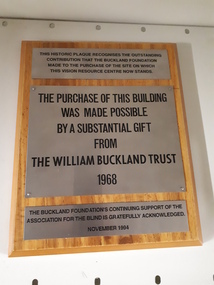
The William Buckland Trust (now Foundation) provides support for disadvantaged Victorians through support for four key areas. The growing need for space at the Association for the Blind's offices in Kooyong was constraining the amount of people who could benefit from it's programs. With the assistance of the William Buckland and Hecht Trusts, the adjoining blocks of flats fronting Glenferrie Road were acquired and eventually demolished to make way for the Vision Resource Centre. The support from the Buckland Trust in 1968 was not forgotten however, and this plaque acknowledges the support gained in purchasing the land.Digital image of metal plaques attached to a boardThis historic plaque recognises the outstanding contribution that the Buckland Foundation made to the purchase of the site on which the Vision Resource Centre now stands. The purchase of this building was made possible by a substantial gift from the William Buckland Trust 1968. The Buckland Foundation's continuing support of the Association for the Blind is gratefully acknowledged. November 1994.association for the blind, h & l hecht trust, william buckland trust -
 Port Fairy Historical Society Museum and Archives
Photograph
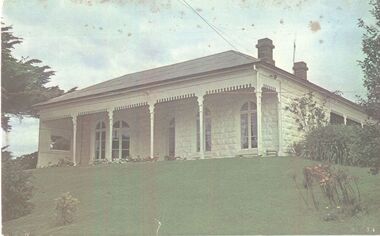
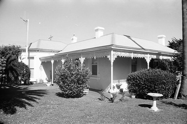
The construction of Seaview commenced in 1860, after David Talbot, purchased the land from James Atkinson,It had been suggested that it was intended to be double storied but there is no evidence of how that would have been accomplished. Following Talbot’s insolvency, Michael O’Reilly leased the house in 1862 until 1876 when he left for Melbourne.William Powling (Solicitor) acquired the house for Eight hundred and twenty three pounds in 1890 and lived there the rest of his life. His son Ernest Powling continued living there before selling it to Matthew Cathcart in 1917.Coloured photograph of White painted stone house with bay window to right and large verandahcottage, building, home, house, seaview -
 Port Fairy Historical Society Museum and Archives
Negative - Photograph
The construction of Seaview commenced in 1860, after David Talbot, purchased the land from James Atkinson,It had been suggested that it was intended to be double storied but there is no evidence of how that would have been accomplished. Following Talbot’s insolvency, Michael O’Reilly leased the house in 1862 until 1876 when he left for Melbourne.William Powling (Solicitor) acquired the house for Eight hundred and twenty three pounds in 1890 and lived there the rest of his life. His son Ernest Powling continued living there before selling it to Matthew Cathcart in 1917.negative, seaview, house -
 The Beechworth Burke Museum Research Collection
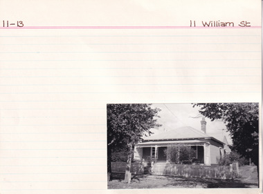
Card (Series) - Index Card, George Tibbits, 11 William Street, Beechworth, 1976
George Tibbits, University of Melbourne. Faculty of Architecture, Building and Town & Regional PlanningIndex system that support the research for Beechworth : historical reconstruction / [by] George Tibbits ... [et al]Arranged by street names of BeechworthEach index card includes: street name and number of property, image of property, allotment and section number, property owners and dates of ownership, description of the property according to rate records, property floor plan with dimensions.beechworth, george tibbitsbeechworth, george tibbits -
 The Beechworth Burke Museum Research Collection
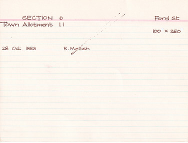
Card (Series) - Index Card, George Tibbits, Ford Street, Beechworth, 1976
George Tibbits, University of Melbourne. Faculty of Architecture, Building and Town & Regional PlanningIndex system that support the research for Beechworth : historical reconstruction / [by] George Tibbits ... [et al]Arranged by street names of BeechworthEach index card includes: street name and number of property, image of property, allotment and section number, property owners and dates of ownership, description of the property according to rate records, property floor plan with dimensions.beechworth, george tibbitsbeechworth, george tibbits -
 The Beechworth Burke Museum Research Collection
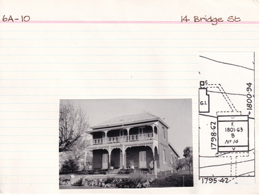
Card (Series) - Index Card, George Tibbits, 14 Bridge Street, Beechworth, 1976
George Tibbits, University of Melbourne. Faculty of Architecture, Building and Town & Regional PlanningIndex system that support the research for Beechworth : historical reconstruction / [by] George Tibbits ... [et al]Arranged by street names of BeechworthEach index card includes: street name and number of property, image of property, allotment and section number, property owners and dates of ownership, description of the property according to rate records, property floor plan with dimensions.beechworth, george tibbitsbeechworth, george tibbits -
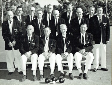 Harcourt Valley Heritage & Tourist Centre
B & W photograph of fourteen men dressed in bowls club uniforms, Harcourt Bowling Club BDBA Pennant Winner Division 3 Season 1966-67, 1967
The inaugural meeting to form Harcourt Bowling Club was held in May 1955. Cr Ben Bingham donated half an acre of land in Bagshaw st Harcourt and the club acquired a small building from Blight's Quarry to serve as a clubhouse. The first day's play took place on 24th October 1959. New clubrooms were built in 1961 with the official opening of the Club held on Saturday 11th November 1961. The club became affilaited with Bendigo District Bowling Assocaition and, in 1966/67 won the Associated division 3 pennant. ; Depicts a group of men, the core ‘movers and shakers’ of the Harcourt community, in the course of their favourite recreation, Association champions in just the seventh year after formation.. Black and white photograph of fourteen men dressed in collar and tie, white trousers and dark blazers, each bearing the club name, HARCOURT BOWLING CLUB B.D.B.A. PENNANT WINNER - DIVISION 3- SEASON 1966-67 and the names of each player. -
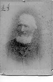 Linton and District Historical Society Inc
Photograph, Mr William Ching Snr
William Ching and his wife Mary migrated from Cornwall to Victoria in 1853. They lived at Buninyong and Geelong before buying farm land at Linton/Happy Valley. The Ching farm was known as 'Ophir Farm'. William Ching died 1917 at Linton age 89. His wife Mary Ching died 1894 age 64 at Linton. William, Mary, and their children Francis William Ching, Mary Ann Ching, and Godiva Marion Ching are all buried at Linton cemetery. Photograph is part of Old Lintonian collection ; No. 23 Sepia photograph of and old white haired bearded man wearing suit.mr william ching snr., old lintonian collection, mary ching -
 Eltham District Historical Society Inc
Document - Folder, Rosier, James Watson and descendants
James Watson Rosier purchased a block in Little Eltham in 1850 and married Nancy or Elizabeth Richards in 1856. Contents Letter Judy Gibson to EHDS, 7 April 1991: Seeks information about James Watson Rosier. Note Sue Law, 9 February 2010: Information about Rosier and Peers sent to Lois Sinclair. Email exchange Malcolm and Wendy Rosier, Nillumbik Historical Society and EDHS, March-May 2016: Information about James Rosier and land purchased in Little Eltham in 1850. Newspaper clippings, A4 photocopies, etcjames watson rosier, nancy rosier nee richards, samual horace richards rosier, carlton and united breweries, little eltham, josiah holloway, humphrey peers, diamond creek, elizabeth rosier, george rosier, thomas rosier -
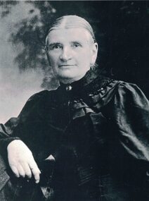 Linton and District Historical Society Inc
Photograph, Anna Rankin
Anna Woods, 1848-1920, was a daughter of James Burns Woods and his wife Anna, née Coates. The Woods family migrated to Victoria in 1864. In 1974, Anna married Ewen Rankin, who held land adjoining her father's property near Linton. Ewen and Anna build a house which they called 'Glenree'. Anna and Ewen Rankin had eight children - Catherine (Kate), James, John, Anna, Mary, Lucy, William (Bill) and Ewen. The Rankins were active members of the Presbyterian congregation in Linton.Black and white photograph which shows a woman wearing a dark dress with full sleeves and a wide decorative collar. A small brooch is pinned on the collar. The woman's hair is parted in the centre and drawn back. Anna Rankin née Woods.anna rankin (née woods) -
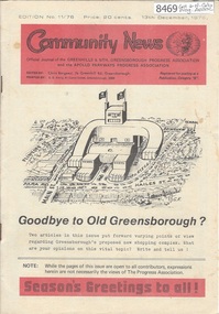 Greensborough Historical Society
Newsletter, Greenhills and North Greensborough Progress Association, Community News: official journal of the Greenhills and Nth. Greensborough Progress Association and the Apollo Parkways Progress Association.13th December, 1976. Edition No. 11/76, 13/12/1976
This edition includes a report on the The Apollo Parkways Progress Association's November 1976 meeting, Goodbye to old Greensborough?, Lament for the loss of my loved one - Greensborough, Is bigger best?, Church of Christ, This and That, A breeding success story, Cameo of Eric and Prisca Rosario, Land of the brave & the free, Grief, Nursing Mothers Association, Parent Australia, From the Council Chamber, School news, Scout news, Plenty Valley Squash Club, Bird survey of Yandell Reserve. A digital copy of this Newsletter is available from Greensborough Historical Society. Newsletter, 24 p., illus., map.greenhills and north greensborough progress association, greenhills, apollo parkways progress association, apollo parkways -
 Falls Creek Historical Society
Booklet - Falls Creek Ski School 1994
Part of yearly marketing and information material promoting the Falls Creek Ski School. This publication includes detailed information about the Falls Creek Ski School and its wide range of programs for 1994. Activities include Kids Ski Land, NASTAR Recreational racing, Ski School Race program as well as an extensive snowboarding program. Family night skiing was available for the first time. Special events included the Ski School International Ball, a TELEMARK and Powderhound Women's program as well as a Kangaroo Hoppet Preparation Clinic.This item is important because it documents seasonal activities at Falls Creek Alpine Resort across all age groups.A glossy booklet featuring images and information about programs to be offered at Falls Creek in the 1994 winter season. The front cover features a photo of two downhill skiers at Falls Creek Ski School. Coloured images are included throughout the booklet. Each page has a different coloured background and black or white text.On Cover: 1994 Falls Creek Ski School SSS FALLS CREEK SKI SCHOOL INFORMATIONfalls creek marketing, falls creek ski school, falls creek ski academy, falls creek race club -
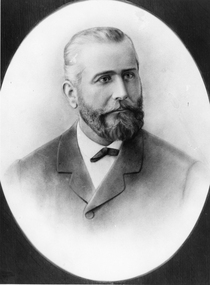 Stawell Historical Society Inc
Photograph, Portrait of Mr Jean Pierre Trouette -- Studio Portrait
Portrait of Jean Pierre Trouette who planted vines at St Peters Great Western 1862. Jean Pierre Trouette, was a Frenchman who had difficulty obtaining a block of land at Great Western about 1862. He was permitted to purchase a small allotment on the Concongella Creek in 1863. In 1863 Jean Pierre and Mr. Blampied began planting grape vines. The winery that Trouette and Blampied established was called St Peters. Jean Pierre was Shire President in 1876. E. Blampied was also Shire President in 1887.Black and white photograph setting oval in a rectangle, mounted in a brown folder. The male is neatly dressed, trimmed hair and beard.great western shire president -
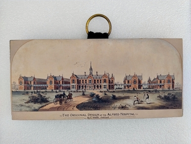 Royal Australian and New Zealand College of Obstetricians & Gynaecologists (RANZCOG)
Print - Colour print, Charles Webb, Original design of the Alfred Hospital, c. 1870
"The Alfred Hospital was founded in 1869 as a result of the work of a number of Melbourne doctors who fought a long and internecine battle for an additional general hospital treating its first patient in 1871. Prahran Council donated a parcel of low lying land for the provision of a Hospital. In 1870, the Melbourne architect, Charles Webb, won the competition to design The Alfred Hospital with his revolutionary design. Webb incorporated the "Nightingale" design principles by designing large light filled pavilions as wards connected by covered corridors or walkways." (Alfred Health)Small colour print mounted on a wood block. Print depicts a series of five red brick buildings at centre, with a dirt road snaking up from the left foreground to the front of the central building. A man is driving a two horse buggy along the dirt road towards the buildings. The landscape on either side of the road consists of grassland and low vegetation, as well as four shallow circular pits (two on either side) which contain vegetation. There are two figures in the right foreground cutting grass with scythes. A flock of birds is visible in the sky in the central background, above the main hospital building. Text printed below image reads 'THE ORIGINAL DESIGN OF THE ALFRED HOSPITAL/By C.Webb, Arckitect (sic)'. The back of the wooden block to which the print is affixes is painted black, and a circular hook has been attached to the centre back of the block for hanging the artwork. The hook is gold coloured, and attached using two gold coloured pins and a small strap. Handwriting at bottom right of the back of the object reads 'ANN TAVELL''THE ORIGINAL DESIGN OF THE ALFRED HOSPITAL/By C.Webb, Arckitect (sic)' -
 Eltham District Historical Society Inc
Photograph, 13 Stokes Place, Eltham, December 1980, 1980
Stokes Place was part of the Stokes Orchard Estate which was developed from the break-up of the the orchard owned by Frank Stokes who lived on the northeast corner of Nyora Road and Eucalyptus Road. His daughter Beryl advised that the Shire had levied a rate assessment on individual parcels of land within the orchard which became unaffordable resulting in its sub-division and sell off. The Stokes Orchard Estate was developed by Macquarie Builders in two stages starting with stage 1 in 1976. Stokes Place was part of Stage 2 in 1979. The Estate was bounded between Nyora Road, Eucalyptus Road, Diosma Road and Stokes Place. The original orchard only just reached the left most portions of Stokes Place and did not go fully up to Diosma, rather to just beyond the extant of Stokes Place. Stokes Place was known within the family as "The Oats" as that is where they grew oats. Frank Stokes moved to Eltham c.1945 after visiting Harold Bird to view his orchard, located diagonally opposite Stokes Orchard from the intersection of Eucalyptus Road, Pitt Street and Nyora Road. It was on Harold Bird's recommendation that Frank purchased the land.The Stokes Orchard Estate collection is typical of housing developments of the late 1970s and 1980s. It was one of the earliest estates in Eltham following the nearby Woodridge Estate development.Digital filestokes place, eltham, stokes orchard, stokes orchard estate, streets, houses -
 City of Moorabbin Historical Society (Operating the Box Cottage Museum)
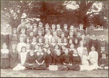
Photograph, Black & White, x2 Cheltenham State School No.84 Charman Rd c 1910, c1910-20
Stephen Charman, 1821-1906 a market gardener, donated land for the first Methodist Chapel, Cemetery and School in Charman Rd Cheltenham 1855. The enrollment was 36 pupils with Mr Frederick Meeres as Teacher. 1863 the school is called Beaumaris Common School No 84 with 70 pupils and Walter Meeres as Teacher. 1869 another 2 acres in Charman Road were granted by the Education Board and brick building built . 1872 State School 84 Beaumaris was increasing enrollments and 1878 a new brick school was built to accommodate 174 pupils and the name changed to Cheltenham State School No.84 1894 Mentone State School No.2950 amalgamated with Cheltenham SS No.84. 1910 the buildings were in disrepair, overcrowding was increasing and renovations were made 1912 with further additions in 1925 and 1937. Post WW11 extra prefabricated Classrooms were added as enrollment increased to 1038 in 1955.. Cheltenham East State School 4754 was opened as housing development spread over the City of Moorabbin . (J.Larson Sandringham HS) The boys wearing round collars are from the Methodist Children's Home Cheltenham 1892-1953 that was situated on land now Southland Shopping Centre 1855 Stephen Charman donated land to the Methodist Church so that a School could be established to educate the children of the early settler market gardeners and farmers in the Cheltenham area . Education was valued by the general community and as well as schools they established mechanics Institutes and Libraries in Moorabbin Shire. Cheltenham State School No. 84 was among the first schools in Melbourne2x Black & White photographs of pupils at Cheltenham State School Charman Rd. c 1910-1920 a) Cheltenham State School No 84 c 1910 b) Cheltenham State School No.84 c 1910-1920 Grade 6a) Handwritten Cheltenham ( Charman Rd ) School / probably about 1910 b) " Charman Road School / taken probably between 1910 & 1920cheltenham primary school, methodist children's home cheltenham 1892-1953, city of moorabbin, county of bourke, moorabbin roads board, parish of moorabbin, shire of moorabbin, henry dendy's special survey 1841, were j.b., bent thomas, o'shannassy john, king richard, charman stephen, highett william, ormond francis, maynard dennis, cheltenham state school no.84, methodist chapel cheltenham, methodist school cheltenham, beaumaris west state school, meeres frederick, meeres walter, education, early settlers, cancel -
 City of Moorabbin Historical Society (Operating the Box Cottage Museum)
Lights, porcelain, wall, electric light switch; Door Knob Porcelain, early 20th C
Both the Light switch and Door knob were used in Box Cottage during the late 19thC and early 20thC by the Box and Rietman families. William and Elizabeth Box purchased the two ten acre Lots of land with the Cottage in 1868 where they raised their family of 12 children and developed a flower garden producing seedlings. August and Frieda Rietman rented the Cottage 1917 with 1 acre of land and purchased it in 1935 where they raised 2 children while August established Rietman's Landscaping Pty Ltd making pressed concrete garden furniture. Porcelain is a ceramic material made by heating materials, generally including kaolin, in a kiln to temperatures between 1,200 and 1,400 °C The toughness, strength and translucence of porcelain, relative to other types of pottery, arises mainly from vitrification and the formation of the mineral mullite within the body at these high temperatures. Porcelain and other ceramic materials have many applications in engineering, especially ceramic engineering. Porcelain is an excellent insulator for use at high voltage, especially in outdoor applications, see Insulator (electricity)#Material. Examples include: terminals for high voltage cables, bushings of power transformers, insulation of high frequency antennas and many other components. Both the Light switch and Door knob were used in Box Cottage during the late 19thC and early 20thC by the Box and Rietman families. William and Elizabeth Box purchased the land with Cottage in 1868 and raised their familya) An electric light switch that would be attached to a wall. An Ivory Porcelain Base Single Light Switch with antique Brass top b) A porcelain door knob Both items used in Box Cottage early 20th Ca) On base BRITISH MADE / ENGLAND / 4 / 6959 lights, porcelain, electricity, early settlers, moorabbin, cheltenham, bentleigh, box william, box elizabeth, rietman august, rietman frieda, market gardeners, flower gardens, seedling nurseries, world war 1 1914-18, war memorials, sculpture, pottery, pressed concrete, door handles, door knobs -
 Bendigo Historical Society Inc.
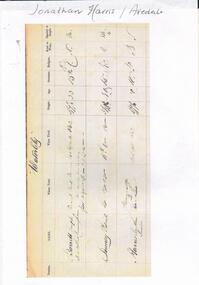
Document - Jonathan Harris / Axedale
Jonathan Harris was born in Sussex England in 1822. His father Jonathan Snr was transported to Australia and his wife obtained permission to follow him as a free settler when Jonathan jnr was about 7 yrs.In 1842, Jonathan snr (who held a ticket of leave) and his son Jonathan Jnr were found guilty of theft and transported to Tasmania. Family history suggests that following his term, Jonathan jnr became a police detective before returning to Victoria. He and his wife had a store at Third White Hill in Bendigo and one day while walking to Eaglehawk, Jonathan found a rich vein of gold in what was to become the Hustlers Mine. He took large samples to England for crushing and subsequently sold his claim. Upon returning to Melbourne he conducted a business before taking up land at Axedale. He farmed here, including the growing of apples up until his death 20/7/1881. His efforts must have been successful as following his death the sale of property at Axedale included two pieces of land that each had two cottages that had been rented out. Jonathan was also on the board of the Axedale School.An 8 page document detailing the life of Axedale man Jonathan Harris.view street, house, goldfield -
 Wodonga & District Historical Society Inc
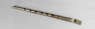
Functional object - Haeusler Collection Child's Metal Recorder
The Wodonga Historical Society Haeusler Collection provides invaluable insight into life in late nineteenth and early twentieth century north east Victoria. The collection comprises manuscripts, personal artefacts used by the Haeusler family on their farm in Wodonga, and a set of glass negatives which offer a unique visual snapshot of the domestic and social lives of the Haeusler family and local Wodonga community. The Haeusler family migrated from Prussia (Germany) to South Australia in the 1840s and 1850s, before purchasing 100 acres of Crown Land made available under the Victorian Lands Act 1862 (also known as ‘Duffy’s Land Act’) in 1866 in what is now Wodonga West. The Haeusler family were one of several German families to migrate from South Australia to Wodonga in the 1860s. This recorder belonged to Alfred Haeusler (b.1922) and was played during his childhood in Wodonga in the 1920s-1930s. The recorder is one of several objects in the Haeusler Collection concerning early childhood that provides insight into family and home life in early twentieth century Wodonga. Recorders belong to the family of woodwind instruments and were first produced in the early eighteenth century. The instrument was popularly revived in 1919 by English instrument maker Arnold Dolmetsch. This item has well documented provenance and a known owner. It forms part of a significant and representative historical collection which reflects the local history of Wodonga. It contributes to our understanding of domestic and family life in early twentieth century Wodonga, as well as providing interpretative capacity for themes including local history, social history, and women’s history. Plated iron alloy recorder with visible rust, roughly 20cm long. "MADE IN JAPAN"/"SK"music, musical instrument, recorder, wind instrument, school, child, childrens, haeusler collection, music lesson, woodwind instrument -
 Wodonga & District Historical Society Inc
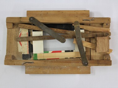
Functional object - Haeusler Collection Hand Made Photograph Printing Frame c. early 1900s
The Wodonga Historical Society Haeusler Collection provides invaluable insight into life in late nineteenth and early twentieth century north east Victoria. The collection comprises manuscripts, personal artefacts used by the Haeusler family on their farm in Wodonga, and a set of glass negatives which offer a unique visual snapshot of the domestic and social lives of the Haeusler family and local Wodonga community. The Haeusler family migrated from Prussia (Germany) to South Australia in the 1840s and 1850s, before purchasing 100 acres of Crown Land made available under the Victorian Lands Act 1862 (also known as ‘Duffy’s Land Act’) in 1866 in what is now Wodonga West. The Haeusler family were one of several German families to migrate from South Australia to Wodonga in the 1860s. This homemade photographic printing frame was built by Louis Haeusler (b.1878) and demonstrates his engineering capabilities. Rather than purchase the required materials for his home dark room processing, Louis would make any tools he needed from found materials around the Haeusler family home. Louis’ photographic equipment is among the many objects in the Haeusler Collection that represent home and social life in early twentieth century Wodonga. The item is handmade and unique, with well documented provenance. It forms part of a significant and representative historical collection which reflects the local history of Wodonga. It contributes to our understanding of domestic and family life in early twentieth century Wodonga, as well as providing interpretative capacity for themes including local history and social history. A handmade photographic printing frame, constructed from timber, paper, nails, glass and sticky tape. photography, photos, photographic, photographs, family photos, family photography, darkroom photography, dark room photography, printing, printing frame, wodonga, haeusler, haeusler collection -
 Wodonga & District Historical Society Inc
Album - Haeusler Collection Family Scrapbook Album Belonging to Ilma Haeusler c. 1910s - 1920s
The Wodonga Historical Society Haeusler Collection provides invaluable insight into life in late nineteenth and early twentieth century north east Victoria. The collection comprises manuscripts, personal artefacts used by the Haeusler family on their farm in Wodonga, and a set of glass negatives which offer a unique visual snapshot of the domestic and social lives of the Haeusler family and local Wodonga community. The Haeusler family migrated from Prussia (Germany) to South Australia in the 1840s and 1850s, before purchasing 100 acres of Crown Land made available under the Victorian Lands Act 1862 (also known as ‘Duffy’s Land Act’) in 1866 in what is now Wodonga West. The Haeusler family were one of several German families to migrate from South Australia to Wodonga in the 1860s. This scrapbook album belonged to Ilma Margaret Ernestine Haeusler (née Tasker), born in 1900 in Tallangatta. Ilma died in childbirth in 1928, leaving her husband Louis Alfred Haeusler (b.1878), and one surviving son, John Alfred Lyell (b.1922). The scrapbook was gifted to Ilma from her Aunt and contains Tasker family photographs, and postcards and greeting cards Ilma received in the 1910s-1920s.This item has well documented provenance and a known owner. It forms part of a significant and representative historical collection which reflects the local history of Wodonga. It contributes to our understanding of domestic and family life in early twentieth century Wodonga, as well as providing interpretative capacity for themes including local history, social history and women's history.An olive green photographic album with a red, green and yellow floral motif on the front cover. First page inside front cover, handwritten pencilled inscription: "Ilma Margaret Ernestine Tasker/ To Ilma/with love/from Auntie Annie/wishing her a happy/Birthday". album, scrapbook, family, family album, wodonga, haeusler, haeusler collection, photographs, photograph, postcard, christmas card -
 Wodonga & District Historical Society Inc
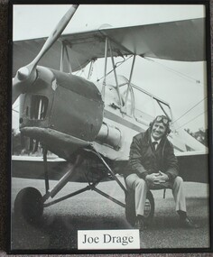
Photograph - Joe Drage and his Tiger Moth, Rob Elliott, 1993
This image is one from a series of portraits taken by Rob Elliott to record the character of the Border District through the faces if its identities. Born on 10 July 1931 in Walwa, Joseph Gordon (Joe) Drage operated a timber mill and earthmoving business, but his great passion was aviation. After obtaining his pilot’s licence at the age of 19, Mr. Drage set about buying vintage aircraft that he feared would be sold overseas. He bought his first aircraft, a Tiger Moth in 1965. In 1972 he established Drage Historical Aircraft Museum on about 60 ha of land in Wodonga, with 5 planes. Over time this grew to 21 planes which Joe maintained so that they were all in flying order. His museum was the location for several air shows which included fly-ins by members of the Antique Aeroplane Association. The land occupied by the Museum was compulsorily acquired by the Albury-Wodonga Development Corporation and Wangaratta council bought the aircraft collection for about $2 million. They opened Drage Airworld in 1984. The cost of maintaining the collection became too much for the council which closed it down in 2002. Joe Drage died on 9 August 2017.This portrait depicts a person who made a significant contribution to the Wodonga community.A portrait of Joe Drage sitting on the wheel of his Tigermoth. The photo has been mounted in a metal frame.joe drage airworld, aircraft museum wodonga, joe drage -
 City of Kingston
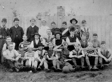
Photograph - Black and white, c. 1908
Australian rules football began being played on a regular basis in Cheltenham in 1890. Teams would not only play locally but travel by train fairly long distances, such as to Ballarat, for the day, play a game, turn around and come home. The Cheltenham home games were played on a paddock on the corner of Park and Charman roads in Cheltenham. In 1907 the Cheltenham progress committee made an application to the board of land works for land in Weatherall Road for recreational service to the public. That application was received and granted, then developed where Cheltenham Recreational Reserve now stands. The ground was opened in 1909 and the first Cheltenham side entered in the newly formed Federal Football League along with seven other foundation members, Mordialloc, Mentone, Moorabbin, Frankston, Glenhuntly, Elsternwick, and Ellindale. The grand final for that year, 1909 was a hard encounter between Cheltenham and Ellindale with Cheltenham coming out victors, thus becoming the inaugural Federal Football League premiers. The Federal Football League (FFL), also known simply as the Federal League, was an Australian rules football competition in the south-eastern suburbs of Melbourne, Victoria. The competition was in existence from 1909 to 1981 and was regarded as one of the strongest metropolitan leagues in Melbourne.Black and white image of the players and officials of the Cheltenham Football Club. Back (left to right) G Puttick, Franklyn (sic), Unkown, Unknown, C Corstorphine, D Arland, Dave Hughes, H Bryant, Centre: T Elliott, S Parsons, F Judd, H Foreman, N Corstorphine, J McCormack, S Chandler, H Orr. Front: H Clayton - no other names recorded. The players are wearing what appears to be a range of club jumpers, with some in street wear. Some players seated in the front row have mud visible on the soles of their shoes, indicating they may have already played a gam. The ball on the ground in front of the group is round.Round red sticker on reverse with handwritten text: X10 Handwritten in blue ink: A11, with a circle around it Handwritten in red ink: 50%sport, football, cheltenham, teams, federal football league -
 Stawell Historical Society Inc
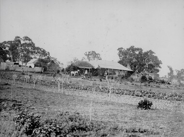
Photograph, "Allanvale" Home Station in Great Western 1866
Allanvale Home Station. Part of a collection of Photographs by Mr. O.G. Armstrong as commissioned by the Shire of Stawell for the Inter-colonial and Paris Exhibition in Melbourne in 1866. Allanvale was taken up about 1841 by John Allen, who was the son of George Allan of Allanvale, near Launceston in Van Diemen's Land. He selected 80,000 acres between present day Stawell and Ararat. The property was gradually reduced in size, with the first split occurring in the 1840s with the annexation of Concongella Selection due to a land dispute. J.S. Davidson was the occupier of Allanvale at the time this photograph was taken. The homestead pictured here was destroyed by fire at the end of the First World War and replaced by a new building around 1923. The present owners of Allanvale are the Kilpatrick family A note on the Allan family. On the 15th of March 1845, John Allen's 26 year old wife died at the birth of their third child, a daughter, who also died several weeks later. Elizabeth Allen had been a dear friend of Mrs Horatio Wills of neighbouring Lexington station. Eliza and her daughter were buried side by side in the garden of Lexington homestead. She was said to have been the first white woman to have died in the district. Homestead and stables on left with people on verandah and orchard in foreground.stawell great western -
 Eltham District Historical Society Inc
Document - Report, Dimity Reed et al, Advisory Commlttee Hearing on Permit Applications 96/0376, and 96/0377, and on Planning Appeals 96/40724 and 96/40812 re a proposed convenience centre at 895 Main Road, Eltham, June 1997
On 15 December 1994 the former Shire of Eltham ceased to exist following the Liberal Kennett Government local council amalgamations. A new Nillumbik Shire Council was established with unelected commissioners appointed. That Council sold the former Eltham Shire Council Offices and land at 89S Main Road Eltham to Dallas Price Homes Pty. Ltd. the sale being conditional upon the granting of a planning permit for a petrol station/convenience store, fast food and video outlet. The sale was conditional that if the permit was not granted by 30 August. 1997, the contract could be avoided by either the purchaser or the vendor. The proposed development consisted of a petrol station with undercover fuelling facilities, convenience shopping, a drive through service facility for fast food, an 80 seat cafe, automated banking, a children's play area and retail space. In addition, the proposal included a 200 square metre community facility for Council use, provision of on site carparking over 2 levels for 83 vehicles, and advertising signage. The Advisory Committee was appointed under Section 151 of the Planning and Environment Act 1987 to hear submissions on the proposal to develop the land at 895 Main Road Eltham, the site of the former Eltham Shire Offices. In September 1996, two applications were made by Contour Consultants Australia Pty Ltd on behalf of Dallas Price Homes Ply Ltd, to Nillumbik Shire Council. After extensive notification, the Council received 213 objections and a petition of over 1400 signatures. On October 9, 1996, Nillumbik Shire Council issued Notices of Decision to Grant Permit on Applications number 96/03376 and 96/0377 for the use and development of the land as a convenience Centre consisting of a petrol station, convenience store, cafe/takeaway food premises, a retail facility and a community facility, with associated advertising signs. Objectors to the proposals lodged Planning Appeals number 96/40724 and 96/40812 with the Administrative Appeals Tribunal on November 1, 1996. The grounds of appeal can be summarised as: inappropriate development, insufficient carparking, traffic and access issues, unsatisfactory design, inadequate permit conditions, the proposal being out of character with the area. and being contrary to the purpose and orderly development of the Eltham Town Centre, excessive noise, lack of consultation and unsuitable signage. On November 13, 1996, the Minister for Planning and Local Government directed the Registrar of the Administrative Appeals Tribunal. under Section 41 (1) (a) of the Planning Act 1980, to refer the Appeals to the Governor in Council for determination without a hearing or recommendation by the Tribunal. The Minister for Planning and Local Government called in the Appeals as he considered that they raised major issues of policy relating to the facilitation of development in accordance with the objectives set out in Section 4 of the Planning and Environment Act 1987, and that determination of the Appeals could have a substantial effect on the achievement of these planning objectives. The Minister required the Advisory Committee to consider the planning merits of the proposed use and development, and to address the issues raised in the objections. The Advisory Committee was required to produce a report providing: • The Committee's response to the matters detailed; • Relevant supporting information for the Advisory Committee's recommendation; and • A description of the proceedings conducted by the Advisory Committee and a list of those consulted or heard by the Committee. In March 1997, elections were held in the Shire of Nillumbik and the view of the new Council to this proposal differed from the view held by the earlier Council Hence the Submission made to the Committee by the Shire was against the decision by the Shire of Nillumbik to issue the Notices of Decision to Grant a Permit. The Recommendations of the Advisory Committee were: i. The cafe and take away food premises are as of right uses and are therefore allowable, but that shop and petrol station are unacceptable uses. A community facility is a discretionary use and is acceptable. ii. A development of the type and scale proposed is totally inappropriate for this land and that the Applications number 96/03376 and 96/0377 for the use and development of the land as a convenience Centre consisting of a petrol station, convenience store, café/takeaway food premises, a retail facility and a community facility, with associated advertising signs, be refused. iii. The land should be rezoned for public purposes and should remain in the community's ownership for community use. 895 main road, advisory committee, dallas price homes, eltham, eltham shire office, nillumbik shire council, planning application, administrative appeals tribunal -
 Ringwood and District Historical Society
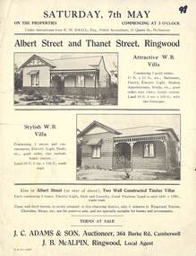
Flyer, Auction Sale Brochure - Adjoining Weatherboard Villas, Albert Street and Thanet Street, Ringwood - circa 1921
Single page advertisement with black and white photographs of two adjoining timber villas fronting Albert Street and Thanet Street, Ringwood for auction on Saturday, 7th May (1921?).Under instructions from E.W. Smail, esq., Public Accountant, 31 Queen Street, Melbourne. Two well constructed timer villas, each containing 5 rooms, electric light, bath and laundry, good position, land to each 66ft x 258 ft., made road. These well-built homes, so nicely situated in this charming district, only 6 minuts to Ringwood Station, Churhes, Shops, etc., are for positive sale, and are specially suitable for homes and in estments. Terms at sale. J.C. Adams & Son, Auctioneer, 364 Burke Road, Camberwell. J.B. McAlpin, Ringwood, Local Agent. -
 Eltham District Historical Society Inc
Photograph, Peter Pidgeon, Grave of John and Mary Murray, Eltham Cemetery, Victoria, 5 April 2021
Irish-born John Murray and his wife Mary (daughter of Thomas Sweeney) married in 1849 and settled in Eltham North. John and Mary were amongst the earliest inhabitants of Eltham. John was a farmer and their block of about 80 acres, called ‘Laurel Hill’, was on the eastern side of the Diamond Creek, extending east to beyond Zig Zag Road. It was later extended southward by the purchase of a further 60 acres. He is recorded as a supporter on the petition for a school in Eltham and he served on the National School Board of the Eltham school. John died in 1867 and is buried in Eltham Cemetery with Mary and with two of their grandchildren. Their eldest son Johnnie inherited the property. Then in about 1902 his younger brother James purchased about 50 acres on the western side of the Diamond Creek immediately opposite Laurel Hill, extending west to slightly past Wattletree Road. Eltham North Reserve now lies just beyond the southern boundary. James built a family home on top of the hill on the northern boundary, together with a dairy and milking shed and a food cellar. It is thought that the barn with stables was already there. When Johnnie died in 1912, the two properties (though severed by both the creek and the railway line) effectively merged. The land was worked as an orchard with apples, pears, quinces, and possibly apricots and peaches. Later it became a dairy farm. By 1986, almost all the land had been sold off for residential subdivision and the house had been condemned as unfit for habitation. John's grandson Jim retained a small portion of the land and built a new house. He kept the old one as a storage shed, but it was demolished after he died in 1993. The very old barn is still standing. Located in the Roman Catholic section In Memory of John Murray Who died Dec. 1867 aged 50 years Also his wife Mary Murray Who died 7th Sep. 1909 aged 76 years And of their grandchildren Thomas and Mary Ellen DrainBorn Digitaleltham cemetery, gravestones, john murray, mary ellen drain, mary murray, thomas drain -
 Eltham District Historical Society Inc
Photograph, The Stokes family home and orchard blanketed with snow, corner Nyora and Eucalyptus roads, Eltham, Winter 1951, 1951
Taken from outside the family home on the southest corner of the intersection of Nyora Road and Pitt Street with Eucalyptus Road. Frank Stokes first traveled to the district by train in 1944 to find land with the intention to establish an orchard. By chance he met Arthur Bird of Bird Orchard (bounded by Pitt Street, Eucalyptus Road and Wattle Grove) and they got talking over their common interest. Arthur put Frank up for the night and pointed out the land, part of Crown Allotment 15, Section 5, Parish of Nillumbik (CA15) somewhat diagonally opposite Bird Orchard. Frank bought the land and for the next two years would travel by train from Melbourne to Eltham every weekend establishing Stokes Orchard and building a home for his family, which they eventually moved into in 1946. Marjorie North remembered well the winter of 1951, when she took children, including son John together with the Shallard and Squire children “in the Austin A40 up the Main Rd., Eltham to farmer Bell’s property alongside the Eltham College. They were able to make a snow man and throw snowballs. (Diamond Valley News, August 5, 1986.p.42) In the mid 1970s the Shire of Eltham divided the orchard up into numerous rate-able parcel lots, which became affordable for Frank. As a consequence Stokes Orchard was turned into a housing development by Macquarie Builders and marketed as the Stokes Orchard Estate in two stages; Stage 1 encompassing Scarlet Ash Court, Ironbark Close and Peppermint Grove bounded by Nyora and Eucalyptus roads c.1976 and Stage 2 encompassing Stokes Place, Orchard Way, The Crest and The Lookout bound by Nyora and Diosma roads c.1979. The development of Orchard Way, The Crest and The Lookout did not proceed as planned due to the lack of the sewer along Diosma Road and so many of the proposed lots were incorporated into five-acre parcels instead.Representative of the orchard growing areas of Eltham. One of the rare times it has snowed in Eltham.Digital file only - Digitised by EDHS from a scrapbook (containing commercially printed photos of digital scans) on loan from Beryl Bradbury (nee Stokes), daughter of Frank Stokes.1951, beryl bradbury (nee stokes) collection, eltham, nyora road, eucalyptus road, snow, stokes family home