Showing 10880 items
matching land
-
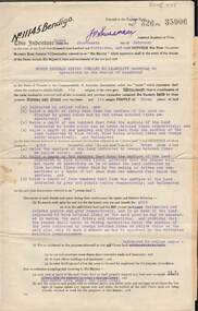
 Ballarat Heritage Services
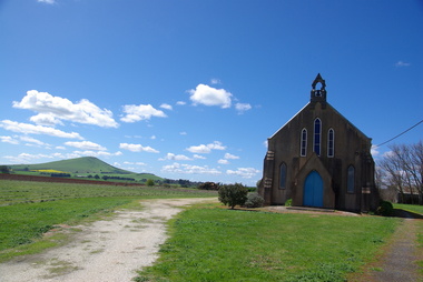
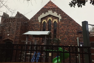
Photograph - Photograph - Colour, Smeaton Presbyterian Church, 2015, 18/12/2015
The Smeaton Presbyterian Church was built in 1859 of locally made brick, and opened in 1860. The building committee was . Messrs. John Hepburn, W. McAlpine, W. Anderson, S. Moore, W. H. Clarke and W. Miller. It cost an estimated 1,200 pounds, and was assisted by Captain John Hepburn who donated 5 acres of land and 150 pounds for the church. The rest was contributed by the settlers and their employees. Around 1890, the outside brickwork was given a coat of cement, which has improved with age. In 1938 the grey stained exterior was described as “not altogether displeasing”. Colour photographs of Smeaton Presbyterian Church.smeaton, smeaton presbyterian church, churches, kooroocheang -
 Robin Boyd Foundation
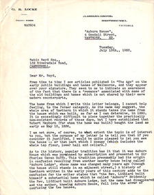
Letter, G. R. Locke, G R Locke to Robin Boyd, 15.07.1952
The letter writer G. R. Locke has read Robin Boyd's newspaper articles on early public buildings and homes. This letter tells Boyd about the historic home "Auburn House", 4 Goodall St Hawthorn, established for Robert Hepburn with land purchased in 1856. It also tells of the confusion with neighbouring house "Auburn Lodge". Since Boyd writes on early Melbourne public buildings and homes, the writer is inviting Boyd to view the house. It is not known whether Robin Boyd took up the invitation. In 1960 it was included in the National Trust Register. -
 Otway Districts Historical Society
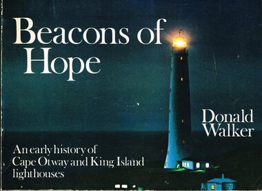
Book, Neptune Press Pty Ltd, Beacons of Hope, 1981
George Bass and Matthew Flinders made a voyage along the northern coast of Van Diemen's Land in 1798 to prove the existence of Bass Strait. The first vessel to attempt such a passage was the "Lady Nelson" under Lieutenant James Grant. Men sought out Bass Strait without the benefit of a lighthouse for the first half of the 19th Century after which, after several maritime disasters, on 29 August 1848, Cape Otway lighthouse commenced operation. Cape Wickham lighthouse, on King Island, joined its companion at Cape Otway on 1 November 1861.Beacons of hope. An early history of Cape Otway and King Island lighthouses. Donald Walker. 1st ed. Neptune Press; Belmont (Vic); 1981. ii, 154 p.; illus., maps, index. Soft cover. ISBN 0 909131 67 8Signed by author: Donald Walker.cape otway; king island; cape wickham; lighthouse; -
 Otway Districts Historical Society
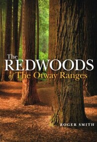
Book, Lothian Custom Publishing, The redwoods of the Otway Ranges. Roger Smith, January 2015
This book is the remarkable story of the world's tallest tree species, the Redwood, growing in the Great Otway National Park in Victoria's south-west. It was originally planted by Victorian foresters for experimental purposes on land abandoned by the early settlers. The Coast Redwood, native of California, is now thrives in the Otways alongside the famous eucalypt, the towering Mountain Ash. The majestic Otway Redwoods, still in their youthful growth phase, have withstood adversity caused by fire, landslide, lighting and chainsaws, while the ongoing political debate about the conservation of the valuable forest resources continues.The redwoods of the Otway Ranges. Roger B. Smith. Lothian Custom Publishing; Middle Park (Vic); 2015. ii, 202 p.; illus., maps, appendices, notes. IBSN 978 1 921737 13 8. Soft cover.With best wishes from Roger Smith. -
 Kew Historical Society Inc
Photograph - Photographs, Former Baptist Church, Woodlands Avenue, Kew East, 2018, 2018
The former Baptist Church, at 8-12 Woodlands Avenue, Kew East, was nominated by the Society for protection as part of the Kew East Heritage Gap Study. W D Vaughan in his 'Kew's Civic History' (1960 writes that: "With the development of East Kew, local Baptists considered the establishment of a church was necessary. A block of land was purchased in Woodlands Avenue and the foundation stone of a new church was laid on August 8, 1931. A fine Sunday school has since been erected, and special emphasis has been given to providing activities for the young people of the church"Three colour photographs of the former Baptist Church in Woodlands Avenue, Kew East. The photographs are of the front and side of the clinker brick building. One of the photographs shows the foundation stone, laid by AH Lewis Esq, 8 August 1931.churches - kew (vic), baptist church - woodlands avenue - kew (vic) -
 Surrey Hills Historical Society Collection
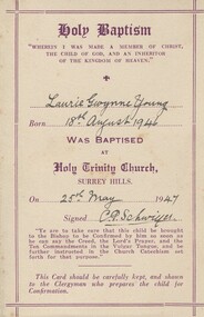
Baptism certificate, 25 May 1947
Rev. C. P. Schwieger, known as Percy, was vicar at Holy Trinity from October 1934 to 1953. Many Children in Surrey Hills were baptised by him as there was a population explosion following WW2. There is a stained glass window of Mary and Martha with Jesus that he donated to the church in memory of his wife Mary, obit. 6.4.1949. He oversaw many improvements to the church properties over the time when the parish was extending to St Augustine in Balwyn and land was obtained for the church at Wattle Park, now closed. REF: Holy Trinity Archives.A cream baptism card printed in brown with ink inscriptions."Laurie Gwynne Young / 18th August 1946 / 25th May / 47 / C P Schwiger"laurie young, laurie newton, churches, rev c p schwiger, rev c p schwieger -
 Vision Australia
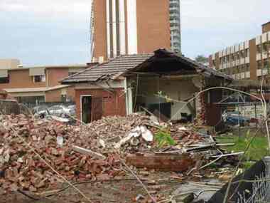
Photograph - Image, Demolition of Raleigh Street premises, 200
On September 23, 1925 the State Goverment gazetted a transfer of land in Raleigh Street, Prahran to RVIB. This was used to establish a hostel for women apprentices and workers, and building commenced in 1926 and was completed in 1927, at a cost of 3500 pounds. Demand for accommodation was strong and in 1929 a hostel for men was completed. The building were used as hostels for many years, but as demand decreased, the Institution found other ways to utilise the buildings. In 1972, a plant nursery was established on the site and other departments temporarily used the site. In 1994 the Employment Services team moved out of the building and the site was sold to developers.17 col. images of the partially demolished house at Raleigh Street, Prahranroyal victorian institute for the blind, raleigh street hostel -
 Vision Australia
Text, Association for the Advancement of the Blind Home Committee January 1937 - November 1941, 1937-1941
Minutes of the monthly meetings of the AAB Home Committee held at 7 Mair Street, Brighton to discuss items related to the running of the Brighton home for the Blind (later named 'Elanora'). A brief index of names preceeds the minutes. Agenda topics included Accounts, Matron's Report, Applications for Admission and Official Visitors, rules for admission and guidance (p.i), dissatisfaction between staff (p.19), installing ear phones in the infirmary (p.103) and the potential purchase of land at the rear of the home (p.168). Correspondence and an inmates register have been listed for some of the period. 1 paper registerassociation for the advancement of the blind, elanora home (brighton) -
 Melton City Libraries
Letter, Letter to Martha Myers, Unknown
Letter was sent to Burnbank, former Ann Dowling (Miers) 1866 Crown Grant. In 1867 she married Henri Miers and their house was located on the site near the Myers Gully part of Ryans Creek. Built in 1867 and later named “Burnbank” by Martha Myers after the Street in Ballarat were she lived before arriving in Melton in 1907. “Burnbank” was vacated by Martha to her new house built on the family land in McKenzie Street. A demolition order imposed by the Housing Commission and it was pulled down by the family in 1969. It was the home of the family and stood for over 100 year.Letter from Edna Barrie and Bruce Myers, children of Martha Myerslocal identities -
 Tarnagulla History Archive
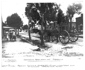
Photograph of the north end of Commercial Road, Tarnagulla, North end of Commercial Road, Tarnagulla, c. 1909
Murray Comrie Collection. This photograph shows business on the north end of Commercial Road, Tarnagulla. From right: the brick Baptist Church (now private residence), Stafford's Blacksmith Coachbuilders and funeral/undertakers (since demolished), & Norwood's Tarnagulla Hotel. Information collated by Murray Comrie: Stafford's premises were built on land previously occupied by the stables of the George Hotel. The Stafford's building was later taken over and run by Frank McNamee. This photograph is a dark copy created from an older original. Copy probably made by Murray Comrie in the 1970s. Monochrome photograph depicting the north end of Commercial Road, Tarnagulla. A large wagon with team of horses is standing in the road. Three girls are walking down footpath at left side of image.Written on the original: 'Specially produced for Renshaw & Co' and 'Commercial Road (North End) Tarnagulla'. Written on this copy: 'Baptist Church Staffords Blacksmith Coachbuilders and funeral/undertakers, & Norwood's Tarnagulla Hotel'.tarnagulla, commerce, industry, blacksmithing, smithing, coachbuilding, businesses, stafford, norwood, mcnamee, buildings, hotels, churches, commercial road, main street -
 Tarnagulla History Archive
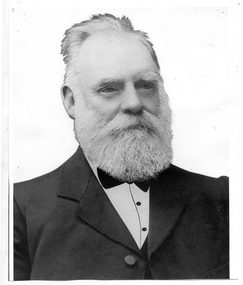
Photograph of John Shields Simpson, circa 1880s
Murray Comrie Collection. Information written by Murray Comrie: John Shields Simpson was born in Scotland in 1831, came to Victoria in 1853 and after mining for a time took up land at what was later to be the Nick O'Time Lead at Poseidon. He took up a store at Newbridge and in 1905 built a hotel alongside the store. Both were severely damaged in floods of the Loddon River in 1909. He was elected to the Tarnagulla Borough Council in 1882 and retained his seat until 1915 when he resigned. He was Mayor of the Borough on five occasions. Monochrome photographic portrait of a bearded man.Accompanying note identifies subject as John Shields Simpson.borough of tarnagulla, john shields simpson, mayor, council, local government, local people, newbridge, store, hotel -
 Sunbury Family History and Heritage Society Inc.
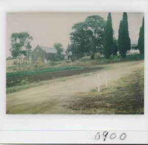
Photograph, Goonawarra Winery, c1970s
The property in the photograph is the winery building at Goonawarra Vineyard, which is situated on the east side of Jacksons Creek and on the north side of Macedon in Sunbury. The winery and homestead were established in 1858 by James Goodall Francis, who received a crown grant of land in Sunbury. From 1865 to the 1920s, the vineyard produced white wine grapes. James Goodall Francis died ion 1884 and the property was brought by M.P.Synott who ran merino sheep on the property. It wasn't until the early 1980s that Goonawarra reverted to be a vineyard after the property had been in the hands of a variety of owners. Goonawarra was one of Sunbury's earliest wineries to be established in the area.A coloured polaroid photograph with a white border, of a pathway leading to a double storey buildinggoonawarra winery, james goodall francis, wineries, jacksons creek -
 Warrnambool and District Historical Society Inc.
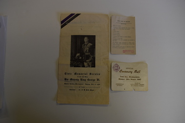
Memorabilia - Two articles of civic events in Warrnambool, Kaye & Son, Warrnambool Printers, mid 20th century
The card relates to the Official Centenary Ball held in the Warrnambool Town Hall in March 1947 to celebrate the city's Centenary in 1947. Warrnambool was founded as a port settlement to service the farming interests in the area, with the first land sales held in Melbourne in July 1847. The leaflet is a programme of the Civic Memorial Service held in the Botanic Gardens in Warrnambool in February1952 on the occasion of the death of King George VI of England. Both items came from memorabilia held by the Bamford family of 8 Monash Avenue Warrnambool and it is presumed that one or more members of that family attended the events.These items are of social significance as mementos of events in Warrnambool in the mid 20th century..1 A white card with black printing and a logo .2 A sheet of white paper folded to make four pages with black printing and a photograph of King George VI of Englandwarrnambool memorabilia, warrnambool centenary, warrnambool centenary 1947, official centenary ball. -
Melbourne Tram Museum
Document - Research Essay, Leigh J Harding, "Development of Tram Engine Houses", 1966
Research Essay, possibly the final draft, by Leigh J Harding looking at the engine houses that powered the Melbourne cable tram system from an Engineering and Architectural viewpoint. Has pencil notations to where photographs would be placed. Provides details on the background to their construction by the Melbourne Tramways Trust in the 1880s. Includes notes on the land acquisition, site plan, internal layout plan and notes on the operations and disposal. Notes on the Essendon, Bendigo and Ballarat power stations are included. The author was a Melbourne University Architecture student with this very detailed study part of his course.Yields information about the Melbourne cable tram engine houses and similar buildings.Report - 82 foolscap pages - typed and handmadetramways, tramcars, cable trams, engine house, winding houses, architects, power station -
 Bacchus Marsh & District Historical Society
Map, 'Map of Darley' circa 1877-1897
This map shows the early laid out streets and roads for the village of Darley and the main roads and streets in the central area of the township of Bacchus Marsh. The date of the map is not known. Landmarks indicated on the map including the Anglican Church in Church Street (Gisborne Road), opposite the Presbyterian Church, and the Baptist Church at its pre-1898 Main Street location suggest the map is dated between 1877 and 1897. Landholders names can be seen on some of the allotments of land marked in this map, including the names Clifton, Cosgrove, O'Hagan, McFarlane, Nagle, O'Hagan, Simpson and Vallence.A single page paper map showing the village of Darley and the township of Bacchus Marsh. Scale 10 chains to 1 inch. The map is pasted into a bound volume containing 76 maps or plans in total. High resolution digital image stored on BMDHS computer network. darley victoria maps, bacchus marsh victoria maps -
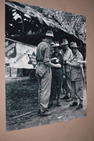 Wangaratta RSL Sub Branch
Photograph, c1945
TARAKAN, BORNEO, 1945-05-08. GENERAL SIR THOMAS A. BLAMEY, COMMANDER-IN-CHIEF, ALLIED LAND FORCES, SOUTH WEST PACIFIC AREA, (4), DRINKING COFFEE WITH SENIOR OFFICERS OUTSIDE THE SALVATION ARMY RED SHIELD HUT DURING HIS INSPECTION TOUR OF THE 2/23 INFANTRY BATTALION. IDENTIFIED PERSONNEL ARE:- BRIGADIER D.A. WHITEHEAD, COMMAND 26 INFANTRY BRIGADE, (1); LIEUTENANT COLONEL F.A.G. TUCKER, (2); LIEUTENANT COLONEL DWYER, (3); LIEUTENANT GENERAL F.H. BERRYMAN, GENERAL OFFICER COMMANDING 1 CORPS (5). Brigadier David Adie Whitehead had a distinguished and decorated career in both First and Second World Wars. He joined the Citizen Military Forces when it was raised in 1947 and commanded the 2nd Armoured Brigade (4th/19th Prince of Wales’s Light Horse and 8th/13th Victorian Mounted Rifles Regiments) till 1953 The 2/24th Battalion was an infantry battalion of the Australian Army, which served during World War II .A unit of all-volunteers, it was formed in July 1940 from primarily Victorian volunteers and was known as "Wangaratta's Own" because of the time the battalion spent in the town during its formative period prior to deployment overseas. It served in North Africa in 1941–1942 as part of the 26th Brigade, which was assigned to the 7th Division, before being reassigned to the 9th Division. In early 1943, the battalion returned to Australia and later took part in campaigns against the Japanese in New Guinea in 1943–1944 and Borneo in 1945, before being disbanded in 1946. The 2/24th suffered the highest number of casualties of any 2nd AIF infantry battalion. The Unit was granted the Freedom of the City by the Rural City of Wangaratta in 1990 and one of the first, if not the first, to receive this type of honourReproduced black and white photograph of four Army Officers having a brew under roof of thatched hut and in front of banner of The Salvation Army/Australian Comfort Fund Handwritten on note attached to rear -Whitehead on L Blamey on R - Qld tablelands (?)general blamey, brigadier whitehead, 26th brigade -
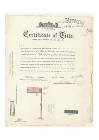 Ringwood and District Historical Society
Document, Certificate of Title - Leslie Mills of Plymouth Road, East Ringwood, Farmer - part of Crown Section 20, Parish of Warrandyte, County of Evelyn - 19th January, 1932
A4 copies of Landata Victoria Historical Search documents - Vol 5781 Fol 1156174.Leslie Mills is now the proprietor of an Estate in Fee-simple subject to the Encumbrances notified hereunder ... 10 acres or thereabouts, together with a right of carriage way over Grandview Grove (later Bemboka Road), Warranwood, Victroia. Transfers include Alexander William Brown of Tooradin, Farmer - 29th October, 1945, (died 25th June, 1957), Probate granted 28th January, 1958, to Alfred Hart Brown of Dandenong, Estate Agent, and Harry Britten Elms of Cardinia, Gentleman (*** See Probate details below) Oliver Burgess, Grandview Grove Ringwood, Florist - 14th May, 1964, Privatus Proprietary Limited, St.Kilda Road, Melbourne - 27th October, 1977, John Patrick Kelly, Company Director and Yvonne Gloria Kelly, Married Woman, joint proprietors, 10th September, 1980 *** Inventory of Real Estate Assets (for Probate purposes 4/10/1957) detailed in Family Genealogy record for A.W. Brown includes: "Grandview Grove, Ringwood Land containing 10 acres or thereabouts situate in Grandview Grove Ringwood being part of Crown Section 20 Parish of Warrandyte County of Evelyn and being the land described in Certificate of Title Volume 5781 Folio 174 on which is erected a 7 room house, a bungalow, shed and 2 glass houses valued by E. Miles, Ringwood - £5077-0-0 -
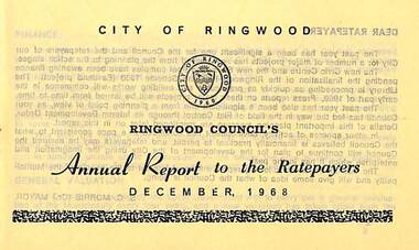 Ringwood and District Historical Society
Pamphlet, Ringwood Council's Annual Report To The Ratepayers - December 1968, 1968
City of Ringwood community information annual report for 1968, including sections covering Finance, General Valuation and Rater Payments, Property Ownership Changes, Refuse, Sanitary Serviced, Sewerage Connections to MMBW, Dandenong Valley Authority, Residential Flat Control Planning Scheme, Immunisation, Home Help, Elderly Citizens' Clubrooms, Library, Civic Centre, Golf Course, Sale of Council Land, Swimming Centre, Holiday Play Centre, Civic Week, Lake Reserve Improvements, Rubbish Dumping, Street Trees, Vandalism, White Ants, Street Construction, Fire Hazards, Dog Nuisance, House Numbering, Citizens' Advisory Service, Infant Welfare Centres, and a list of departing and current Council Representatives. Also includes general reminders regarding rat extermination, free firewood for age pensioners, overhanging vegetation, and spouses voting rights.Obituary - Mr. F.P. Dwerryhouse, Town Clerk for the past 9-1/2 years passed away on 6th December after a short illness.rinx -
4th/19th Prince of Wales's Light Horse Regiment Unit History Room
Christmas Card, 1917
A small, coloured Christmas card showing the rising sun badge, a sketch of purple pansies and the words" To greet you and wish you a Merry Christmas" on the front. There is a green woven cord down the spine holding the internal sheet on which is written "Christmas, 1917. Did you hear a whispered "Coo-ee". Did you feel a clasping hand, When the Christmas bells were ringing, In Australias Golden Land? For in my thoughts I send them you, From the shatter'd fields of war, That we might meet, greet as in dear days of yore; And O how low distant distant seem those times, When you and I were near, Oh would the Southern Cross and you were shining on me here. From 2987 Sapper C A Roney 1st Aust Divn Signal Coy AIF France"As describedchristmas card, ww1, france -
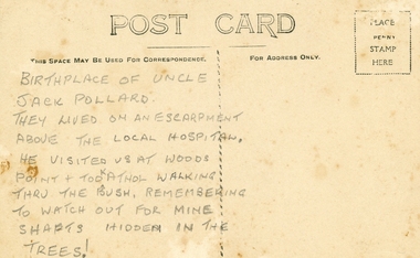 Ringwood and District Historical Society
Photographs, Collection of Pollard Photographs, Ringwood (Undated -probably early 1900's). Also Woods Point 1900, circa 1900
Pollard Photographs:; 1. Back of postcard of the Pollard home in Wonga Road (also called Anderson Creek Road Road, and now Warrandyte Road).; 2. One bushel net apples, J Pollard, Victoria, Australia.; 3. Joseph and Emma Pollard and Family. Emma is nursing baby Ethyl.; 4. Ringwood PS photograph. Jack Pollard is second from the RHS in the back row.; 5. Woods Point with arrow indicating mine manager's house: that of Joseph Pollard. Circa 1900. The Pollard family had a 20 acre orcharding property between Mullum Mullum Road and Wonga Road. Given on 4th September 2010 by Arthur Lunt from his cousin. The Pollard family. School photo at Ringwood State School. Jack�s father was Joseph � land (orchard) between Mullum and Wonga Roads +Additional Keywords: Pollard -
Bendigo Historical Society Inc.
Document - NEW CHUM & VICTORIA LINES OF REEF - NEW CHUM & VICTORIA LETTER & NOTES
Handwritten letter to Mr Blake with reference to meeting students and the changes in Bendigo. Mentioned are the Log Lock-Up, the Central Deborah Mine, the ex-manager of the mine, Mr Rowe acting as a guide, Victoria Hill and the Bendigo Pottery. The notes titled ''To replace Around the Goldfields'' mentions the Third Edition, 'Historic Guide to Bendigo', published in 1969 of land reclaimation schemes rapidly removing all traces of several mines. Those affected on the New Chum Line of Reef are; The Victoria Consols, Ironbark and Hercules and Energetic. The Sheepshead Line - the Ironbark and Ironbark South. On the Garden Gully Line - The Cornish United, Koch's Pioneer and Confidence Extended. The Paddy's gully Line - The British American, Lansell's Sandhurst (Needle) and the Collman and Tacchi. On the Derby Line - Johnson's No 3 (Nelson) and on the Hustlers Line are the United Hustlers and Redan and the K. K. Mines. Also a carbon copy of the notes.document, memo, new chum & victoria lines of reef, new chum & victoria letter & notes, mr blake, mr hattam, log lock-up, central deborah mine, mr rowe, victoria hill, bendigo pottery, historic guide to bendigo third edition, new chum line of reef, the victoria consols, ironbark, hercules and energetic, sheepshead line, ironbark, ironbark south, garden gully line, cornish united, koch's pioneer, confidence extended, paddy's gully line, the british american, lansell's sandhurst (needle), collman and tacchi. derby line, johmson's no 3 (nelson), hustlers line, united hustlers and redan, k k mines -
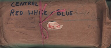 Bendigo Historical Society Inc.
Document - MCCOLL, RANKIN AND STANISTREET COLLECTION: CENTRAL RED WHITE AND BLUE - BUNDLE OF PAPERS, 1912
Documents: Whitelaw Central Red White and Blue Mine Bendigo. 28 pages summary of gold mining correspondence - mortgage mining leases 943689340, contract of sale to Central Blue Gum GM 1933, leases with mining rights, treatment of pyrites agreement 1917 - J. Edwards & Co, Helen Streader - release of liability after being paid (pounds)125 by mine due to accidental death of husband 1912. Another for Ellen Lane 1916, list of titles held by Co , lease agreements Filcock and Manning, Andrew Harkness 'winding plant at mine' 1923, notice to perform agreement to Manning's 1916, Edwards Metallurgical Works 1917, map for 9777 Bendigo, contract for explosives with Dalgety & Co 1917, new scrip for lost shares 1917, Miner's Right 1911, sale of land Ra. A. Rankin 1910.MCCOLL RANKIN AND STANISTREETorganization, mining, central red white and blue, mccoll rankin and stanistreet. -
Victorian Aboriginal Corporation for Languages
CD, Judy Holt et al, Wambaya : Northern Territory : Warumungu Tennant Creek, 2005
1. Father 2. There's a Land 3. Amazing Grace 4. Where Will You Spend Your Eternity? 5. Silent Night 6. Three Wisemen 7. Are You Washed in the Blood of the Lamb? 8. God is So Good 9. I'm Not Alone 109. Come Oh Lord 11. He is Lord 12. Father You Live in Heaven So High 13. At the Cross Road 14. He Took My Place 15. Jesus Died on the Cross 16.It's the Lily of the Valley 17. We are Gathered Here Together 18. We are One in a Bond of Love 19. Upon my Heart I have a Burden 20. Story: Hunting for Goanna and Bush Tucker 21. Skin Group for Wambaya People (as per law and culture) 22. A Story: Bush Tucker Collection and Preparation (according to traditional customs)CDnorthern territory, warumungu, tennant creek -
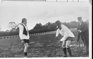 Southern Sherbrooke Historical Society Inc.
Photograph - Photo - Oldies vs Youngies football captains, Bill Hermon and Haldon Westcomb
B&W photo shows three men in a muddy field, possibly a sports ground. A white fence with uprights and a top rail edges the field behind them, and the land beyond the fence is heavily treed. The man on the left is wearing a hat, possibly a fedora, white dress shirt and bowtie, a black tuxedo waistcoat, dark boxer shorts or shorts, socks and shoes or laceup boots. He appears to have dark glasses and a moustache. The man in the middle also has a hat, a white shirt and shorts, and what appears to be a large dark bowtie or cravat. He is wearing long socks with suspenders, and laceup boots or shoes. He is bent forwards as if catching or throwing something. The man on the right has a peaked cap, a long dark coat over a shirt and trousers, and either dress shoes or boots. He is holding a stick and other items. dated c.1950s. -
City of Kingston
Photograph - Colour, 6 March 1993
Edithvale is a suburb in the City of Kingston. It is located between Aspendale and Chelsea on the Port Phillip Bay and built within remnant areas of the Carrum Carrum swamp. The foreshore precinct comprises a wide sandy beach, with low sand dunes and numerous historic boat sheds. The suburb consists of older style dwellings and former holiday houses, combined with mid-century housing and newer homes. The large blocks are increasingly subdivided and the existing dwellings demolished to accommodate units and townhouses, thus changing the landscape of the area and reducing the tree canopy.The beachside suburb of Edithvale was previously part of the extensive Carrum Carrum Swamp. The area was once a source of fish and eels for the Mayone-Bulluk clan of the Bunurong people. Over time the area was drained and predominantly devoted to dairy farming and holiday houses. The farms were gradually sold and subdivided with a large number of homes built after World War II and in the 1960s. Edithvale is mainly residential with a shopping strip along Nepean Highway but little significant industry was ever established in the area apart from a plaster works and confectionary factory, both now closed.Laminated aerial colour photograph of Edithvale as viewed from Alexandra Avenue in the north to Ella Grove Chelsea/Edithvale in the south. regents Park Aspendale can be seen in the top left. The area is built-up with residential housing and facilities including Edithvale Primary School, numerous churches and the Edithvale Railway station. Large sections depict the remnant Carrum Carrum swamp. Edithvale Common and the former "Duck Inn" (Melbourne Water/Friends of Edithvale Seaford Wetlands) can be seen. Edithvale Recreational reserve, the valodrome and Edithvale Public Golf Course are prominent. The image shows vacant land in the area now known as Aspendale Gardens and the newer residential section of Chelsea Heights is not developed. A bike path has been established to cover the secondary drain. The Golf Links Court residential development located off Hughes Avenue is a large vacant block.Black type on white adhesive label: 6-3-93 Black type on white adhesive label: 25/9211, 6/3/93, 11.20 am Black type on white adhesive label: 9211 Yellow circular adhesive sticker Black pencil: 9211 6-3-93 arrow pointing Nedthvale, carrum carrum swamp, aspendale, chelsea -
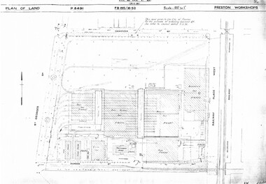 Melbourne Tram Museum
Drawing, Melbourne & Metropolitan Tramways Board (MMTB), "Preston Workshops", c1938
Set of nine photocopied plans or drawings on A3 sheets of the "Preston Workshops" - c1939 .1 - P8491 - Plan of land showing layout and associated drawings including Reservoir railway line - 19-4-1939. .2 - P8492 - Plan of Timber stacks and Hall - 3-2-1939 .3 - P8493 - Plan of Offices and location of sub-station - 13-12-1938 .4 - P8494 - Plan of Store including Oil store - c1939. .5 - P8495 - Plan of Paint Shop and relationship to timber stack - 1-3-1939 .6 - P8496 - Plan of Car building and Repairs shop - 6-12-1938 .7 - P8497 - Plan of machine shop - 10-12-1938 .8 - P8500 - Plan of Blacksmiths shop - 1-12-1938 .9 - P8590 - Plan of Substation - 1-12-1938trams, tramways, drawings, depots, property, preston workshops, workshops, substation -
 Melbourne Tram Museum
Document - Report, Prahran & Malvern Tramway Trust (PMTT), "The Prahran and Malvern Tramways Trust - Report and Statement of Accounts, Nov. 1918
Photocopy of Report - 32 foolscap pages - titled "The Prahran and Malvern Tramways Trust - Report and Statement of Accounts for Twelve Months ending 30th September 1918". Gives listings of Trust Members and Officers, lines opened, Rollingstock, power supply problems, Finance, Operation and General matters, statistics, finance statements, balance sheet and Auditors Report. Appendices includes the Engineers and Manager's Report, Statistics, accounts, funding, auditor reports and maps. Also covers concession fares for soldiers, purchase of tyre, battery maintenance, traffic at Victoria St bridge, Honor boards, arbitration and land for a storage site. Lists names of Employees who volunteered for active service, including those who volunteer but did not pass the medical test. Audited by Percy P Cook. See htd2389i2.pdf for the listing of those who served in WW1Has the stamp of the Tramway Museum Society on the rear of the first page.trams, tramways, pmtt, reports, construction, finances, operations, horse trams, tourist tickets, world war 1, unions -
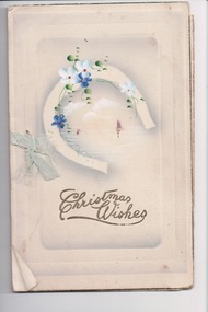 Wangaratta RSL Sub Branch
Card - Assorted cards and photographs
From the album of WWI soldier William West (1268) of the 29 Infantry Battalion, 5th Pioneers Battalion. These postcards, photographs and clippings were sent to William's family and loved ones during the years he was on active service. See also 207 and 220. Assorted cards and photographs nested within a larger card. 1. Bi-fold Christmas card with blue flowers and horseshoe 2. Black and white photograph of a man wearing a suit and hat in a green / grey cardboard oval window mount 3. Sepia photograph of a man in a suit in a dark grey oval window mount 4. Small rectangular card with round edges and handwritten message from Mrs William West 5. Plastic and paper card with yellow cover and rose detail, pink ribbon binding 6. Small black and white landscape photograph of Ypres with "magpie cigarette" branding on back 7. Small slip of paper with inscription: "Pohoto" 8. Small rectangular card with white string binding and oval black and white photograph of a horse and carriage and printed detail of a kangaroo and wattle. Inscription reads: "Greeting from Wattle Land"album, photo album, newspaper clippings, postcard, wwi, christmas wishes, photograph, moustache, sepia, ypres, wattle land, australia, magpie cigarettes -
Surrey Hills Historical Society CollectionThe Armitstead family operated a woodyard and ice delivery business in Union Road, Surrey Hills. There are a number of photos in this collection documenting this business. The family lived nearby in Croydon Road. The site of the woodyard is now the Surrey Hills Neighbourhood Centre.
-
 Bendigo Historical Society Inc.
Document - MCCOLL, RANKIN AND STANISTREET COLLECTION: INDENTURE GOLD MINING LEASE NO. 11145 CROWN AND NORTH DEBORAH MINING COMPANY, 14th February, 1941
6 page document plus map : Gold mining lease No. 11145 between Crown ( King George VI) and North Deborah Mining Company, Parish of Sandhurst, dated 14th February, 1941. Map: Lease No. 11145 'Mining District of Bendigo, County of Bendigo, Parish of Sandhurst. Total area 48 acres, 3 roods, 22 perches. Map has extensive colour key indicating depths below surface that will be mined. Crown land and surface excised shown in orange cross-hatching. Lease holdings on map: 10753, 11020, 1363 T.L., 1115 T.L., 11013, 11062, 11033, 9988. Dam shown on 11013. Railway line marked through centre of map. Map refers to central area of Bendigo and includes reference to Hargreaves Street, Violet Street, Lily Street, Breen Street and Sullivan Street.bendigo, mining, north deborah mining company, breen street, lilly street, hargreaves street, voilet street, sullivan street.