Showing 10880 items
matching land
-
 Eltham District Historical Society Inc
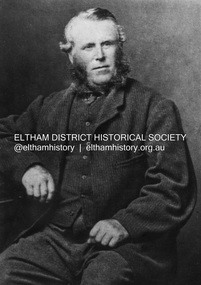
Photograph, John Bell, 1820-1891. Died Violet Bank (now Moray), Kangaroo Ground, 1891
John Bell - Bell, John J.P. Kangaroo Ground, a Scotchman by birth, born in 1819, came out to Melbourne in 1839 in the ship David Clarke, and after remaining in Melbourne one year, and for a short time at Bulleen, went in 1841 to Kangaroo Ground, and purchased 160 acres of land where he now resides, having also 270 acres at Yarra Flats. At the time he settled on the Kangaroo Ground there were but three people in the district, of whom two were shepherds, and the entire country was bush. Mr John Bell’s father, the late Mr. William Bell, first purchased land, and with the assistance of his sons, cleared, fenced, and subdivided it. Mr John Bell has been a member of the shire council since its formation, and for the past twelve years has been a justice of the peace; and he is a member of the National Agricultural Society of Victoria. He has three sons and two daughters, all married. from "Victoria and its Metropolis: Past and Present" written in 1888 by Alexander Sutherland. Chapter 19, "The Upper Yarra District" pages [402] - 415. Includes descriptions of some townships and short biographies of local residents. Page 405 Died at Violet Bank (now Moray), Kangaroo Ground. This photo forms part of a collection of photographs gathered by the Shire of Eltham for their centenary project book,"Pioneers and Painters: 100 years of the Shire of Eltham" by Alan Marshall (1971). The collection of over 500 images is held in partnership between Eltham District Historical Society and Yarra Plenty Regional Library (Eltham Library) and is now formally known as the 'The Shire of Eltham Pioneers Photograph Collection.' It is significant in being the first community sourced collection representing the places and people of the Shire's first one hundred years.Digital imagesepp, shire of eltham pioneers photograph collection, kangaroo ground, john bell (1820-1891), violet bank -
 Glen Eira Historical Society
Album - Album page, St Stephen's Presbyterian Church, Balaclava Road, Circa 1972
This photograph is part of the Caulfield Historical Album 1972. This album was created in approximately 1972 as part of a project by the Caulfield Historical Society to assist in identifying buildings worthy of preservation. The album is related to a Survey the Caulfield Historical Society developed in collaboration with the National Trust of Australia (Victoria) and Caulfield City Council to identify historic buildings within the City of Caulfield that warranted the protection of a National Trust Classification. Principal photographer thought to be Trevor Hart, member of Caulfield Historical Society. Most photographs were taken between 1966-1972 with a small number of photographs being older and from unknown sources. All photographs are black and white except where stated, with 386 photographs over 198 pages. From: Glen Eira Heritage Management Plan (1996) by Andrew Ward and Associates: In 1905, the land was vacant in Balaclava Road, north side, from Kooyong Road east to the right of way, except for one house. A block of this land was acquired by the Presbyterian community and a timber church erected there in 1910. In time, a larger church was required. After several years of fund raising led by George Kinross, a new red brick St Stephen's church was built in 1926 to the design of architects Haddon and Henderson. George Currie was the builder and the cost of construction was £5,100.Glen Eira Heritage Management Plan 1996 by Andrew Ward St Stephens has architectural importance as a noteworthy example of a Gothic Transitional design in the Arts and Crafts eclectic manner (see Stylistic Typology in National Trust's Historic Church's Study}. The facade treatment successfully combines Christian symbols with Gothic forms in the Arts and Crafts mode (comparable with Haddon's Presbyterian Church, Malvern (1906) and Haddon and Henderson's Oakleigh Church (1928). It is locally important as an example of Robert Haddon's work in Caulfield, where he also lived (4 Glenferrie St q.v.).Page 24 of Photograph Album with four black and white photographs of St Stephen's Presbyterian Church, with Balaclava Road written on the top right hand side. Three photos are of the exterior and one is a wide view of the inside towards the altar.Hand written: St Stephen's Presbyterian Church Balaclava Road [top right of page] / 24 [bottom right]trevor hart, caulfield north, balaclava road, george kinross, haddon and henderson, george currie, st stephen's, 1900's, 1920's, gothic transitional, christian symbols, arts and crafts, robert haddon, stylistic typology, gothic, presbyterian church, architects, red bricks, entrances -
 Glen Eira Historical Society
Album - Album page, St Stephen's Presbyterian Church, Balaclava Road, Circa 1972
This photograph is part of the Caulfield Historical Album 1972. This album was created in approximately 1972 as part of a project by the Caulfield Historical Society to assist in identifying buildings worthy of preservation. The album is related to a Survey the Caulfield Historical Society developed in collaboration with the National Trust of Australia (Victoria) and Caulfield City Council to identify historic buildings within the City of Caulfield that warranted the protection of a National Trust Classification. Principal photographer thought to be Trevor Hart, member of Caulfield Historical Society. Most photographs were taken between 1966-1972 with a small number of photographs being older and from unknown sources. All photographs are black and white except where stated, with 386 photographs over 198 pages. From: Glen Eira Heritage Management Plan (1996) by Andrew Ward and Associates In 1905, the land was vacant in Balaclava Road, north side, from Kooyong Road east to the right of way, except for one house. A block of this land was acquired by the Presbyterian community and a timber church erected there in 1910. In time, a larger church was required. After several years of fund raising led by George Kinross, a new red brick St Stephen's church was built in 1926 to the design of architects Haddon and Henderson. George Currie was the builder and the cost of construction was £5,100.From: Glen Eira Heritage Management Plan (1996) by Andrew Ward and Associates: St Stephens has architectural importance as a noteworthy example of a Gothic Transitional design in the Arts and Crafts eclectic manner (see Stylistic Typology in National Trust's Historic Church's Study}. The facade treatment successfully combines Christian symbols with Gothic forms in the Arts and Crafts mode (comparable with Haddon's Presbyterian Church, Malvern (1906) and Haddon and Henderson's Oakleigh Church (1928). It is locally important as an example of Robert Haddon's work in Caulfield, where he also lived (4 Glenferrie St q.v.).Page 25 of Photograph Album - four black and white photographs of St Stephen's Presbyterian Church, with two photographs in landscape mode across the top showing information about who designed the building in one and showing the church name and year founded in the other; and two in portrait mode in the bottom section showing 2 different heavy wooden doors.Hand written: 25 [bottom left]trevor hart, caulfield north, balaclava road, george kinross, haddon and henderson, george currie, st stephen's, 1900's, 1920's, gothic transitional, christian symbols, arts and crafts, robert haddon, stylistic typology, gothic, presbyterian church, architects, red brick, doors, memorials -
 Glen Eira Historical Society
Album - Album page, St Stephen's Presbyterian Church, Balaclava Road, Circa 1972
This photograph is part of the Caulfield Historical Album 1972. This album was created in approximately 1972 as part of a project by the Caulfield Historical Society to assist in identifying buildings worthy of preservation. The album is related to a Survey the Caulfield Historical Society developed in collaboration with the National Trust of Australia (Victoria) and Caulfield City Council to identify historic buildings within the City of Caulfield that warranted the protection of a National Trust Classification. Principal photographer thought to be Trevor Hart, member of Caulfield Historical Society. Most photographs were taken between 1966-1972 with a small number of photographs being older and from unknown sources. All photographs are black and white except where stated, with 386 photographs over 198 pages. From: Glen Eira Heritage Management Plan (1996) by Andrew Ward and Associates In 1905, the land was vacant in Balaclava Road, north side, from Kooyong Road east to the right of way, except for one house. A block of this land was acquired by the Presbyterian community and a timber church erected there in 1910. In time, a larger church was required. After several years of fund raising led by George Kinross, a new red brick St Stephen's church was built in 1926 to the design of architects Haddon and Henderson. George Currie was the builder and the cost of construction was £5,100.From: Glen Eira Heritage Management Plan (1996) by Andrew Ward and Associates: St Stephens has architectural importance as a noteworthy example of a Gothic Transitional design in the Arts and Crafts eclectic manner (see Stylistic Typology in National Trust's Historic Church's Study}. The facade treatment successfully combines Christian symbols with Gothic forms in the Arts and Crafts mode (comparable with Haddon's Presbyterian Church, Malvern (1906) and Haddon and Henderson's Oakleigh Church (1928). It is locally important as an example of Robert Haddon's work in Caulfield, where he also lived (4 Glenferrie St q.v.).Page 26 of Photograph Album including three black and white photographs of St Stephen's Presbyterian Church, with two photographs in portrait mode across the top showing 2 different stained glass windows from the inside; and one in landscape mode in the bottom section which appears to be a photograph of a framed photograph or drawing of the church.Hand written: St Stephen's Presbyterian Church Balaclava Road [top right] / 26 [bottom right]trevor hart, caulfield north, balaclava road, george kinross, haddon and henderson, george currie, st stephen's, 1900's, 1920's, gothic transitional, christian symbols, arts and crafts, robert haddon, stylistic typology, gothic, drawings, presbyterian church, architects, lead lights, stained glass windows -
 Glen Eira Historical Society
Album - Album page, St Stephen's Presbyterian Church, Balaclava Road, Circa 1972
This photograph is part of the Caulfield Historical Album 1972. This album was created in approximately 1972 as part of a project by the Caulfield Historical Society to assist in identifying buildings worthy of preservation. The album is related to a Survey the Caulfield Historical Society developed in collaboration with the National Trust of Australia (Victoria) and Caulfield City Council to identify historic buildings within the City of Caulfield that warranted the protection of a National Trust Classification. Principal photographer thought to be Trevor Hart, member of Caulfield Historical Society. Most photographs were taken between 1966-1972 with a small number of photographs being older and from unknown sources. All photographs are black and white except where stated, with 386 photographs over 198 pages. From: Glen Eira Heritage Management Plan (1996) by Andrew Ward and Associates In 1905, the land was vacant in Balaclava Road, north side, from Kooyong Road east to the right of way, except for one house. A block of this land was acquired by the Presbyterian community and a timber church erected there in 1910. In time, a larger church was required. After several years of fund raising led by George Kinross, a new red brick St Stephen's church was built in 1926 to the design of architects Haddon and Henderson. George Currie was the builder and the cost of construction was £5,100.From: Glen Eira Heritage Management Plan (1996) by Andrew Ward and Associates: St Stephens has architectural importance as a noteworthy example of a Gothic Transitional design in the Arts and Crafts eclectic manner (see Stylistic Typology in National Trust's Historic Church's Study}. The facade treatment successfully combines Christian symbols with Gothic forms in the Arts and Crafts mode (comparable with Haddon's Presbyterian Church, Malvern (1906) and Haddon and Henderson's Oakleigh Church (1928). It is locally important as an example of Robert Haddon's work in Caulfield, where he also lived (4 Glenferrie St q.v.).Page 27 of Photograph Album with one photograph of a drawing or perhaps a postcard of St Stephen's Presbyterian Church. It has a large block of formal writing in the bottom right corner which looks official.Hand written: 27 [bottom right]trevor hart, caulfield north, balaclava road, george kinross, haddon and henderson, george currie, st stephen's, 1900's, 1920's, gothic transitional, christian symbols, arts and crafts, robert haddon, stylistic typology, gothic, presbyterian church, architects, drawings -
 Melton City Libraries
Pamphlet, Dry Stone Wall Driving Trail, Unknown
"The dry stone walls provide a tangible link to the area’s white settlement, and they remain a symbol of the profound change in land usage from the original Kulin custodians to the European arrivals of the nineteenth century. The bulk of dry stone wall construction in Victoria occurred between the 1850s and 1880s. The gold rush of the early 1850s in particular inspired a flurry of construction. At this time, labour previously available for shepherding livestock dried up, as men gravitated to the goldfields to seek their fortunes. This necessitated the building of fencing to contain the district’s growing number of sheep, cattle and horses. An explosion in surveying, subdivision and the sale of Crown lands also contributed to a boost in construction. Government regulations that punished pastoralists for allowing their livestock to stray provided further incentive to fence-off previously open expanses of land. The major benefit of this type of fencing was that it utilised the materials at hand; the plentiful grey basalt that scattered the landscape. In the case of the dry stone walls built around Melton, the characteristic round or oval shape of the volcanic fieldstones on the western plains inspired some distinctive designs.54 Another advantage of dry stone walls was their ability to withstand the ravages of flood, fire and drought often experienced in the district. This durability accounts for the fact that many of these fences still exist today". Dry Stone Wall trail brochure/pamphlet for visitors provided by Melton Visitor Information Centrecouncil, landscapes of significance -
 Wodonga & District Historical Society Inc
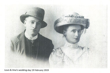
Negative - Haeusler Glass Negatives Collection - Louis Haeusler and Ilma's Wedding Day 19 February 1919
The Wodonga Historical Society Haeusler Collection provides invaluable insight into life in late nineteenth and early twentieth century north east Victoria. The collection comprises manuscripts, personal artefacts used by the Haeusler family on their farm in Wodonga, and a set of glass negatives which offer a unique visual snapshot of the domestic and social lives of the Haeusler family and local Wodonga community. The Haeusler family migrated from Prussia (Germany) to South Australia in the 1840s and 1850s, before purchasing 100 acres of Crown Land made available under the Victorian Lands Act 1862 (also known as ‘Duffy’s Land Act’) in 1866 in what is now Wodonga West. The Haeusler family were one of several German families to migrate from South Australia to Wodonga in the 1860s. Louis Alfred Haeusler was the 6h child of Johann Heinrich Ferdinand Haeusler and Ernestina Wilhelmine nee Rogasch. He married Ilma Margaret Ernestine Tasker in the Presbyterian Church in Tallangatta on 19th February 1919. Ilma was born in Tallangatta, Victoria in 1900 to Michael John Tasker and Louisa Ida nee Schultz. Ilma died in childbirth in 1928 giving birth to a stillborn child. She was survived by her husband, Louis Alfred Haeusler and one surviving son, John Alfred Lyell who was born in 1922.This item is unique and has well documented provenance and a known owner. It forms part of a significant and representative historical collection which reflects the local history of Wodonga. It contributes to our understanding of domestic and family life in early twentieth century Wodonga, as well as providing interpretative capacity for themes including local history and social history.Digital image created from the Haeusler Glass negative collection. A portrait of Louis Haeusler and Ilma Tasker taken on their Wedding Day on 19 February 1919.wodonga pioneers, haeusler family, glass negatives, dry plate photography, wodonga families, early farming -
 Sunbury Family History and Heritage Society Inc.
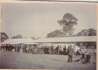
Photograph, Horse Racing, c1900 - 1910
The people in the photograph were enjoying a day out at a Sunbury race meeting some time in the early 1900s. Races at Sunbury began in 1886 with the establishment of the Sunbury Racecourse that was located along Racecourse Road on a section of the Rupertswood Estate on land consisting of six furlongs and two straights. The site included a patron’s stand, saddling paddock, bookmakers’ enclosure, two bars, a committee room, judges box, stables, toilets, six entrance gates and ticket boxes. Special trains from Melbourne brought patrons and horses to the Sunbury race meetings. A report in the Melbourne Argus newspaper in 1922, stated that city taxi drivers came out to Sunbury to drive patrons to the racecourse, which was located about 3 kms from the Sunbury station. Some time however, between 1886 and 1901, there was a period when the racing club had been inactive. A meeting was called in 1901 to restore the club’s activities. With a substantial loan from Mr. Clarke the committee was able to organise the installation of a turnstile, perimeter fencing and irrigation of the course by a windmill that pumped water from a recently constructed dam that was on the estate. The club continued to function until 1942, during World War 2, and did not resume activities after the end of the war. The land was eventually sold for housing development. The Sunbury Race meetings were popular with the racing fraternity not only in the district but further afield and were deemed sufficiently important to run special trains from Melbourne to Sunbury on Race days.A non-digital sepia photograph with a strong cardboard backing of a crowd of people dressed smartly for a day out at the races. Most of the spectators are seated in a long marquee. Three men on the RHS are looking at a horse that is lying on the ground.On the back of the card there are scribbled notes and numbers which seem to indicate the photograph has been used for a publication at some time.sunbury race meetings, sunbury race course, racecourse road -
 Bendigo Historical Society Inc.
Document - MCCOLL, RANKIN AND STANISTREET COLLECTION: NEW STAR GOLD MINE HARRIETVILLE NL, 1935
McColl Rankin & Stanistreet, New Star Gold Mine Harrietville NL. a/ Agreement to purchase the mining operations and land at Black Snake Creek, Dargo, Mining District of Gippsland. For Mining Leases numbers 5187 & 5195, 31 acres. The purchaser Company is to be called Kong Meng Gold Reefs NL. Dated: 16/2/1935. Signed: J A Michelsen?, C Kingsley?, J Stanistreet, E R Grelis & ??? Inscriptions: Signed sealed and delivered by the said Ronald Alexander Rankin in the presence of E R Grelis. b/ Leasehold. Transfer of Land situated in the Parish of Dargo County of Dargo Mining District of Gippsland from New Star Gold Mine Harrietville NL to Kong Meng Gold Reefs NL. Dated: 12/3/1935. Signed: G ??, Geo ??, Stanistreet, G ??, Jamie Jeps ? Markings: pencil line through Gold Mining Lease No. 5187 change to a Leasehold Estate, line through January to be changed to March. c/ Indenture (copy of b/ with adjustments made) New Star Gold Mine Harrietville NL with Kong Meng Gold Reefs NL. Dated 13/3/1935. Signed: G ??, Geo ??, Stanistreet, G ??, Jamie Jeps ?, Stanistreet. d/ Carbon copy of a/. Signed: J A Michelsen?, C Kingsley?, J Stanistreet, E R Grelis & ??? Inscriptions: Signed sealed and delivered by the said Ronald Alexander Rankin in the presence of E R Grelis, J Stanistreet. e/ Indenture, agreement between New Star Gold Mining Harriet NL and Kong Meng Gold Reefs NL, was on the 9/3/1935 registered and Incorporated under the Companies act 1928 Part 2. Signed: E R Grelis, J Stanistreet, G ??, Geo ??, Stanistreet, G M?, Stanistreet. Dated: 12/3/1935.organization, business, gold mine, mccoll rankin & stanistreet new star gold mine harrietville nl black snake creek parish of dargo county of dargo mining district of gippsland mining leases numbers 5187 & 5195 kong meng gold reefs nl 1935 -
 Eltham District Historical Society Inc
Document - Certificate of Title, Landata, Vol. 4930 Fol. 985900, Crown Portion 15 Section 5, Parish of Nillumbik, County of Evelyn, 1925
(Cancelled) Certificate of Title originally issued for Crown Portion 15, Section 5 to Robert David Taylor, of Eltham, County of Evelyn, Farmer, 13 March 1925. It is with this title that the land allotment was subdivided into 48 lots. The title shows the issuance to Robert David Taylor with encumbrance placed upon it by immediate former owner, Hugh Patrick Keogh, a former member for Gippsland and Melbourne Real Estate Agent. Following Taylor's death in 1934 the title passes to his Executors, sons Robert David Taylor of Bible Street, Eltham and William McLelland Vance Taylor of Northcote. The property is then sold to Frank Stokes who develops the Stokes Orchard. Compulsory acquisitions by the Melbourne Metropolitan Board of Works and State Electricity Commission show provisions of easemenst for town water supply and high voltage power transmission lines. Subsequent lots are then sold off with the development of the Stokes Orchard Estate residential development in the mid to late 1970s. A History of the Development of Crown Allotment 15, Section 5, Parish of Nillumbik – Stokes Orchard Crown Allotment 15, Section 5, Parish of Nillumbik (CA15) is a square allotment of 158 acres or approximately a quarter of a square mile. It lies just beyond the eastern end of Pitt Street, south of Nyora Road to the northern end of Eucalyptus Road and extends east from Eucalyptus Road to Reynolds Road. The topography of CA15 is generally steep, sloping up to a hill near the centre of the land, the ridgeline passing through the properties along the southern side of Diosma Road. Eucalyptus Road is a straight north-south road with its northern end at the north west corner of CA15. Until the end of the 1970s this road was an un-named Government Road and was largely not open to traffic. With residential development in the 1970s the road was constructed, and the council allocated the name obviously in recognition of the predominant species of the local bushland. CA15 was purchased from the Crown by George D’Arley Boursiquot, a prominent Melbourne printer, on 28th October 1852. On November 23, 1922, former Member for Gippsland and Melbourne Real Estate Agent, Hubert Patrick Keogh purchased the allotment then sold it March 13, 1925, to local farmer, Robert David Taylor, a former Shire of Eltham Councillor (1911-1920) and Shire President (1919). Taylor had extensive land holdings stretching west towards Bible Street and Main Road. The Taylor home was situated at the top of the hill in Bible Street at present day 82 Bible Street. At the time of Taylor’s purchase in 1925, CA15 was subdivided into 48 lots that could be described as small rural properties or large residential lots. A typical lot size was one hectare or 2.5 acres. The subdivision created two roads, Nyora Road, and Diosma Road, each following an irregular alignment between Eucalyptus and Reynolds Roads. However, the lots were not sold off separately nor were the roads constructed. The land effectively remained as one parcel for many further years. Robert David Taylor died November 30, 1934, and probate was granted to his son of the same name, Robert David Taylor of Bible Street, Salesman and William McLelland Vance Taylor of 73 Emmeline Street, Northcote, Clerk, with the transfer of the land into their names on July 8, 1935. Frank Stokes worked as a qualified accountant at Kennons leather factory in Burnley, while living at 1 Thomas Street, Mitcham. He suffered from migraines and wanted to return to working the land (he had previously worked on farms and orchards since coming to Australia from England in 1926, both in WA and Vic.). He first travelled to the district by train in July 1942 to find land with the intention to establish an orchard. By chance he met Arthur Bird of Bird Orchard (bounded by Pitt Street, Eucalyptus Road, and Wattle Grove) and they got talking over their common interest. Arthur put Frank up for the night and pointed out the land, 158 acres- part of the Taylor Estate- £900, Crown Allotment 15, Section 5, Parish of Nillumbik (CA15) somewhat diagonally opposite Bird Orchard. Stokes applied through the Riverina Agency to purchase the land who in turn applied for permission from Canberra to sell as there was a new government regulation introduced during the Second World War banning land sales except for immediate production. Stokes obtained a loan on his Mitcham house of £600 @ 5% and paid £450 deposit with quarterly payments of £15 spread over 5 years. Stokes was assisted and advised by Arthur Bird who farmed the neighbouring orchard. In early 1943 Stokes took possession and would catch the train out to Eltham on Fridays after work and began building a hut on the corner of Nyora Road and the Government Road (Eucalyptus Road) for shelter and to lock up tools. He established an orchard on the central western part of the land through the centre of which ran a natural waterway (part of the present-day linear park) and was able to pay a neighbour (Hawkins) to help with clearing and fencing 25 acres, and with a horse and single furrowed plough, planted approximately 2,500 fruit trees - cherries, peaches, plums, almonds, pears, apricots and lemons as well as a few apples and oranges; a massive task. Aerial photographs from the 1940s through to the 1990s clearly show the orchard with most of the larger CA15 site remaining as natural bushland. A huge problem was hares and rabbits eating all the new buds off the tiny trees. As well as laying poison he painted the trees with a mixture of cow manure and lime, often working by moonlight. Procurement of wire and wire netting was difficult because of the war but after much effort he obtained a permit from the Agricultural Department for supplies in March 1944. In February 1945 Stokes applied for a permit to build a “packing shed” as no house building was allowed. It was to be 33 feet x 21 feet and cost £312. It was constructed mostly from second-hand materials, which were hard to obtain, especially iron for roofing. Stokes finished work at Kennons on October 31, 1945, and in March 1946 he sold the family home at Mitcham for £1,230 plus £170 for furniture. On May 15, 1946, title to the CA15 property was issued to Frank Howard Alfred Stokes, Orchardist and Gladys Ethel Stokes, Married Woman, both of Pitt Street, Eltham. The family of five then moved into the very unfinished “packing shed” at Eltham, which was a struggle to weatherproof. Eventually rooms were divided off and lined with hessian bags and whitewashed. Their income was firewood (cut and sold), selling rockery stones and cut Sweet Bursaria. (It was discovered during the 1940s that Sweet Bursaria contained the sunscreen compound Aesculin. The RAAF utilised this compound from Sweet Bursaria during WW2 for pilots and gunners.) The orchard’s first fruit sale was a half-case of Le Vanq peaches in December 1947 for the price of 8 shillings. In 1956 plans for house were drawn and Glen Iris bricks purchased (1956 Olympic Rings variant). The building of the house commenced in 1957 - 12 feet of original packing shed was removed – and was completed in 1959. Water was connected from newly built pressure storage on the property at the end of 1959 and the electricity connection for the first time at 3pm on April 29, 1960. The house remains to present day (somewhat modified) at 1 Nyora Road, home to Nyora Studio Gallery. On occasions, spare remnants of the 1956 bricks have been known to be unearthed in gardens on the estate as they were utilised by Frank Stokes to fill in rabbit holes. On May 26, 1950, a parcel of land was compulsorily acquired by the Melbourne and Metropolitan Board of Works on the hilltop to establish an easement for a high-level service reservoir to augment Eltham’s water supply. The project also included pipe tracks for the necessary water mains. The reservoir has now been superseded by higher level water tanks east of Reynolds Road and its former site is now a public reserve. On November 27, 1964, the State Electricity Commission served notice to compulsorily acquire a further parcel through the eastern part of the land for a major electricity transmission line that augmented supply from the La Trobe Valley to Melbourne. The easement was registered February 11, 1966. The easement was widened July 18, 1969 for a second transmission line to be constructed. In 1971 Melbourne Metropolitan Planning Scheme amendments adopted Nyora Road as the boundary between a residential zone to the north and a rural zone to the south. This determined the future development of the land. In the mid-1970s the Shire of Eltham divided the orchard into numerous rate-able parcel lots, the 48 lots having been established in 1925 and the subsequent rates assessment proved unsustainable for Stokes. He commenced selling lots outside the boundary of the orchard, north of Diosma and South of Nyora. However shortly later the land between Nyora and Diosma Roads and west of the electricity easement was sold and subdivided into residential lots, a housing development by Macquarie Builders and marketed as the Stokes Orchard Estate. New streets were created, and most were named after trees, although one, Stokes Place, commemorates the former owners. The development was undertaken in two stages; Stage 1 (1975) encompassing Scarlet Ash Court, Ironbark Close and Peppermint Grove bounded by Nyora and Eucalyptus roads and Stage 2 (1978) encompassing Stokes Place, Orchard Way, The Crest and The Lookout bound by Nyora and Diosma roads. The developer, Macquarie Builders went bankrupt shortly after the release of Stage 2 leaving many purchasers to fend for themselves and arrange for their own independent builders. There were also difficulties with sewerage for the land immediately south of Diosma Road and so the conventional residential lots were abandoned in favour of larger lots. The development of Orchard Way, The Crest and The Lookout did not proceed as planned and the proposed lots were incorporated into five-acre parcels instead. These included a low-density group housing development by the Graves family and the award winning Choong House (1983) with Gordon Ford developed garden immediately next door situated on the ridge of the hill nestled amongst the original bush, Eucalypt trees and Sweet Bursaria. In 1994, Nillumbik Shire Council applied Significant Environment and Significant Landscape overlays upon the properties on the south side of Diosma Road to ensure protection of this natural bush garden environment. With the arrival of the sewer along Diosma Road in the 1990s, most of these five-acre parcels have since been subdivided multiple times. The Choong house presently sits on a 2.7-acre property, which in 2022 Nillumbik Council nominated for Cultural Significance Heritage protection and is considered potentially significant at State level. The Stokes family were also associated with the Eltham Christian Church. In the 1970s this church had met in temporary premises in Eltham. Lots of the original 1925 subdivision remained south of Nyora Road and a number of these lots were utilized for the Eltham Christian School, which was established by the Eltham Christian Church in 1981. The school operated on this site until 2000. The premises are now used by The Vine Baptist Church. By the mid-1980s the whole of CA15 had been developed for residential and school purposes, except for the sections north of Diosma Road and between the transmission lines and Reynolds Road. Sewerage issues had been resolved for the section north of Diosma Road and in 1987 it was in the process of being subdivided into residential lots. The development coincided with the discovery of colonies of the rare and endangered Eltham Copper Butterfly on the site. This resulted in a community and political campaign to save the butterfly habitat. With the co-operation of the land developer the subdivision was altered to create two bushland reserves in the critical butterfly habitat areas. In the late 1980s the State Government was investigating options for establishing a metropolitan ring road link between Diamond Creek and Ringwood. The chosen route was adjacent to Reynolds Road and so this created a freeze on development of CA15 between Reynolds Road and the electricity easement. The ring road proposal was eventually abandoned, and this part of the land was subdivided into low density residential lots. Diosma Road has been discontinued at the electricity easement and the eastern part incorporated into View Mount Court with access from Reynolds Road. The whole of CA15 has now been developed for residential or associated purposes, ranging from conventional density to quite low density south of Nyora Road. Some remnants of the orchard remain, a few cherry trees on the Graves property and a lone apple tree in Stokes Place. The butterfly reserves comprise significant areas of remnant bushland. Linear reserves through the estate link with central Eltham via the Woodridge linear reserve and with Research along the electricity easement. CA15 as it exists today has a complicated history of rural use, Government acquisition, urban development, and community action. References: • “Stokes Orchard, an incomplete history”; Russell Yeoman with Doug Orford • Correspondence, Beryl Bradbury (nee Stokes) • Aerial Photographs, 1931-1991, Landata (landata.vic.gov.au) • Certificate of Title, Vol. 4930 Fol. 985900 • Plan Number LP 10859 neil webster collection, diosma road, eltham copper butterfly, eucalyptus road, ironbark close, nyora road, peppermint grove, power transmission lines, reynolds road, scarlet ash court, stokes orchard estate, stokes place, woodridge estate, frank stokes, certificate of title -
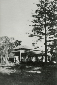
 Eltham District Historical Society Inc
Photograph - Digital Photograph, Marguerite Marshall, 'Worlingworth', 10-26 Banoon Road, Eltham, 30 January 2006
'Worlingworth', Eltham, home of noted anthropologist the late Professor Donald Thomson and his wife Dorita Thomson. Covered under Heritage Overlay, Nillumbik Planning Scheme. Published: Nillumbik Now and Then / Marguerite Marshall 2008; photographs Alan King with Marguerite Marshall.; p127 Dubbed as ‘Australia’s Lawrence of Arabia’ anthropologist Donald Thomson lived much of his life in Eltham, at Banoon Road. On his retirement as Professor of Anthropology in 1968, The University of Melbourne professorial board compared Thomson to Lawrence of Arabia because of his work for Aborigines and his controversial personality. Although Thomson is now recognised for his huge contribution, during his lifetime he suffered opposition and his life has been described as ‘tragic’.1 Thomson failed to gain the recognition as a scientist that he felt he deserved and he failed to alter government policy towards Aboriginal people. But towards the end of his life in 1970, anthropologists were moving towards the type of research he had done and the movement to grant land rights to Aborigines was strengthening. Thomson is best known for his anthropological fieldwork in Cape York, Arnhem Land and Central Australia, but he is also known for his scholarly contributions to ornithology and ecology. Thomson documented every aspect of the daily and ritual life of the Aboriginal world of Cape York and Arnhem Land in the 1930s and 1940s. The huge collection in Museum Victoria includes 11,000 photographs, 7500 items of material culture, 1000 botanical and zoological specimens and 4500 pages of field-notes.2 The film Ten Canoes used Thomson’s photographs as a source. Thomson bought the Eltham property known as Worlingworth in 1934. The single-storey 60-square house standing by the Yarra River was built in 1922-23. It is one of the last in Eltham to survive with its farm setting intact. It is also one of the few substantial residences built in the Eltham Shire from the late 19th century to the early 20th century, which signalled a major change in the area towards the residential municipality it is today.3 The original section, built in the mid 1860s, of rose pink hand-made bricks and stone quarried on the property, was incorporated in the new red-brick house built in 1922. An immense oak tree by the house grew from an acorn brought by Patrick Armstrong who first bought the land in March 14, 1862. Armstrong named Worlingworth after his forbears’ village in Suffolk, England. Worlingworth saw grand days when Commander Alan A Barlee (R.N.) bought it in 1922 after winning the Calcutta Sweep. The property then included a nine-hole golf course, a tennis court, a bowling green, a boathouse and a boat-ramp.4 For most of his career Thomson, who was born in 1901, was attached to The University of Melbourne. In 1935 he represented the Commonwealth Government at Caledon Bay in east Arnhem Land to investigate and mediate for four Aborigines accused of killing five Japanese and three Europeans. In 1938 Thomson was awarded a PhD in Anthropology at Cambridge University, and during his career, he received several medals from British Societies, who perhaps appreciated his work better than their Australian counterparts. From World War Two, Thomson suffered a string of hardships, beginning with severe wounding in Dutch New Guinea (for his military service in New Guinea he was awarded an OBE) and he was invalided from service in 1944. That year he was diagnosed with diabetes. A fire in 1946 destroyed what Thomson regarded as perhaps the best record he had made of Aboriginal life – the 20,000 feet, (6096m) of film he had shot in Arnhem Land. In 1954 he and wife, Gladys, divorced. The next year he married his technical assistant, Dorita McColl. Several times during his career Thomson had major disagreements. For instance Professor P Elkin constantly opposed his work. He also opposed Thomson when he campaigned vigorously in 1947 against the establishment of a rocket range at Woomera, South Australia, because of the threat it posed Aborigines. Thomson resigned in frustration from the Victorian Aborigines Welfare Board in 1967, after serving for ten years, because he found that his advice was disregarded. His ashes were scattered over Caledon Bay from the air.This collection of almost 130 photos about places and people within the Shire of Nillumbik, an urban and rural municipality in Melbourne's north, contributes to an understanding of the history of the Shire. Published in 2008 immediately prior to the Black Saturday bushfires of February 7, 2009, it documents sites that were impacted, and in some cases destroyed by the fires. It includes photographs taken especially for the publication, creating a unique time capsule representing the Shire in the early 21st century. It remains the most recent comprehenesive publication devoted to the Shire's history connecting local residents to the past. nillumbik now and then (marshall-king) collection, banoon road, donald thomson, dorita thomson, eltham, worlingworth -
 Ringwood and District Historical Society
Document, List of bushland reserves in Maroondah - early 2000
Typed document"Attached to List" Hand written note from Helen Moss to Gayle Abbe ( Archivist Ringwood Historical Society) "Here is some information on Dexters Bush and a report I prepared on the bushland reserves in Maroondah which mentions many of the relevant Ringwood reserves. There is also a copy of my phone list for reserves contacts. Roger Lord is listed - so is Anne Kaufman who knows the Angus Avenue/Ruthven Way area very well and may be able to suggest some additions to your heritage list. It would also be worth talking to Eva about the Alexander's land, which is next to Dexter's, on the Dandenong Creek. Good luck, Helen Moss. -
 Ringwood and District Historical Society
Photograph, Ringwood Methodist Church on site at Cnr. Melbourne St. and Whitehorse Rd 1904
Written on backing sheet, "Methodist Church on site at Cnr. Melbourne St. and Whitehorse Rd. On its removal to Greenwood Ave. Mr. J.B. McAlpin built shops on this site - land (Dimmey's) including his own estate agency." One photograph claimed church was moved to Greenwood Ave in 1916. Photograph taken in 1904. Another photograph states that the photograph is of the Methodist Church and Sunday School. Inserted in the sleeve of one of the photographs are two small postcard photographs that state they are, "Methodist Church in Main Street, Ringwood opposite railway station. See Mechanics Institute where Town Hall now stands - c1910. Photo by L. F. East". -
 Eltham District Historical Society Inc
Negative - Photograph, Harry Gilham, Orford family graves, Eltham Cemetery, Victoria, Sep 2009
One of Eltham's earliest settlers was James Orford. Born 1804 in Bedfordshire, the son of George, a carpenter and Lydia Barret, he and wife Sarah Amelia nee Moull (1807) arrived as Assisted Immigrants aboard the ship, ‘Orestes’, November 28, 1839 accompanied by their children, George (14), Mary Ann (11), and James (2). Originally settling in New South Wales, daughter Sarah Amelia was born at Braidwood in 1843 and son, Thomas Henry at Pambula in 1847. James was a carpenter who is known to have built the original gates to Eltham Cemetery. He died in 1869. Around 1890, his son Thomas Henry Orford was living in Pitt Street. Following the death of his wife Helen in 1899, Thomas was appointed by Joseph Panton to look after ‘Panton Park’, a 429-acre bushland property at the fork of Reynolds and Laughing Waters Roads, extending down to the Yarra River. His work entailed ringbarking the manna gums on the property to clear the land for pasture. Thomas lived in a slab hut with his son Ernie, who helped with the work. When Gordon Lyon purchased Panton Park in 1908, Thomas then worked for Lyon at both Panton Park and at ‘Banyule’, Lyon's stud farm at Heidelberg. In 1915 Lyon gave Thomas six acres of land in Reynolds Road with a two-roomed cottage. Thomas died in 1944 and is buried in Eltham Cemetery with his wife and his parents. Another of James Orford's sons was James Matthias Orford. He tried to grow food on land at the end of Laughing Waters Road, but without success. Reputedly the Wurundjeri taught him to swim. He was once imprisoned; when his friend Constable Lawlor invited him to inspect the new bluestone lock-up, Lawlor locked him in and wouldn't release him until he was promised two gallons of beer! ORFORD In Memory Of James 1804 -1869 Sarah Amelia 1807 - 1897 Their son Thomas Henry 1847 - 1944 His wife Helen Amelia 1854 - 1899Roll of 35mm colour negative film, 6 stripsKodak GC 400-9eltham cemetery, gravestones, helen amelia orford, james orford, sarah amelia orford, thomas henry orford, cemetery gates -
 Eltham District Historical Society Inc
Photograph, Peter Pidgeon, Orford family graves, Eltham Cemetery, Victoria, 5 April 2021
One of Eltham's earliest settlers was James Orford. Born 1804 in Bedfordshire, the son of George, a carpenter and Lydia Barret, he and wife Sarah Amelia nee Moull (1807) arrived as Assisted Immigrants aboard the ship, ‘Orestes’, November 28, 1839 accompanied by their children, George (14), Mary Ann (11), and James (2). Originally settling in New South Wales, daughter Sarah Amelia was born at Braidwood in 1843 and son, Thomas Henry at Pambula in 1847. James was a carpenter who is known to have built the original gates to Eltham Cemetery. He died in 1869. Around 1890, his son Thomas Henry Orford was living in Pitt Street. Following the death of his wife Helen in 1899, Thomas was appointed by Joseph Panton to look after ‘Panton Park’, a 429-acre bushland property at the fork of Reynolds and Laughing Waters Roads, extending down to the Yarra River. His work entailed ringbarking the manna gums on the property to clear the land for pasture. Thomas lived in a slab hut with his son Ernie, who helped with the work. When Gordon Lyon purchased Panton Park in 1908, Thomas then worked for Lyon at both Panton Park and at ‘Banyule’, Lyon's stud farm at Heidelberg. In 1915 Lyon gave Thomas six acres of land in Reynolds Road with a two-roomed cottage. Thomas died in 1944 and is buried in Eltham Cemetery with his wife and his parents. Another of James Orford's sons was James Matthias Orford. He tried to grow food on land at the end of Laughing Waters Road, but without success. Reputedly the Wurundjeri taught him to swim. He was once imprisoned; when his friend Constable Lawlor invited him to inspect the new bluestone lock-up, Lawlor locked him in and wouldn't release him until he was promised two gallons of beer! ORFORD In Memory Of James 1804 -1869 Sarah Amelia 1807 - 1897 Their son Thomas Henry 1847 - 1944 His wife Helen Amelia 1854 - 1899Born Digitaleltham cemetery, gravestones, helen amelia orford, james orford, sarah amelia orford, thomas henry orford -
 Eltham District Historical Society Inc
Photograph, Fay Bridge, Clifton Pugh's Artists' Colony, Dunmoochin, Barreenong Road, Cottles Bridge, 14 May 2016
Following military service in the second world war, Clifton Pugh studied under artist Sir William Dargie at the National Gallery School in Melbourne as well as Justus Jorgensen, founder of Montsalvat. For a while he lived on the dole but also worked packing eggs for the Belot family saving sufficient to purchase six acres (2.4 ha) of land at Barreenong Road, Cottles Bridge. He accumulated more land and persuaded several other artists and friends to buy land nearby, resulting in a property of approximately 200 acres, stablishing it as one of the first artistic communes in Australia alongside Montsalvat in Eltham. It was around 1951 that Pugh felt he had '"done moochin' around" and so the name of the property evolved. He bought timber from Alistair Knox to build his house on the crest of a hill. Inspired by local goldminer's huts, it was a one room wattle-and-daub structure with dirt floor. Over the years it expanded with thick adobe walls made from local clay, high ceilings and stone floors. All materials other than the local earth were sourced from second hand materials, most found at wreckers' yards. Artists from across the nation were drawn to Dunmoochin, with several setting up houses and shacks on the property, maintaining their independence but sharing their artistic zeal. Artists who worked or resided at Dunmoochin included Mirka Mora, John Perceval, Albert Tucker, Fred Williams, Charles Blackman, Arthur Boyd and John Olsen. In 2002, Pugh's house along with its treasure trove of art and a library of some 20,000 books was destroyed by fire. Traces of Pugh's home remain with the presence of the Victorian doorframe archway with leadlight of intricate design, procured from a demolished Melbourne mansion; and two bronze life-sized female statues created by Pugh and cast by Matcham Skipper. In place of Pugh's house rose two double-storey mud-brick artists' studios topped with corrugated iron rooves curved like the wings of a bird with accommodation for seven. The original studios, gallery and other buildings survived the fire.fay bridge collection, 2016-05-14, art gallery, barreenong road, clifton pugh, cottles bridge, dunmoochin, maurice hurry -
 City of Moorabbin Historical Society (Operating the Box Cottage Museum)
Photographs x 3 B/W Box Cottage Front House with Pine Trees at Ormond, Frieda in garden c 1921, c1921
In 1855 William and Elizabeth Box migrated from Sussex England to Melbourne and in 1868, 1869 purchased 2 x 10acre Lots in part of Henry Dendy's Special Survey Brighton 1841. A Cottage was already on the land and they established a flower garden and raised 13 children. In 1888 William sold one Lot and built a new Front House . William died 1902 and Elizabeth sold the land except 1 acre and retained both the Cottage and the Front House. After her death in 1914, her daughters Violet and Ada leased the Cottage and Front House to tenants until August Rietmann purchased the property in 1935. August Rietmann (1877-1951) of Lustdorf ,Switzerland, married Maria Frieda Oesschlager (2/2/1878- 22/7/1942) of Baden Baden, Germany on 6/8/1910. In August 8th 1915 August and his wife Frieda migrated to Melbourne, Victoria, Australia sailing on the Steam Ship ‘Osterley’ from Marseilles to Melbourne They leased Box Cottage, Ormond in 1917 and raised two children, Stefanie (1918 -2006) and William (1920- 1997). 1935 August purchased the property and the family used the Cottage during the day and slept in the Front House. August was a monumental mason, potter and sculptor, and was employed at Corbens Ltd Clifton Hill, to carve war memorials in Victoria post WW1 c 1915-1922. During the 1920's August set up his own business in pressed cement making pot plants, columns,paving slabs and lampstands. He continued to carve headstones and figures and took contract work for Artists eg Paul Mountford. He built a workshop in the Barn and used the Cottage for plaster moulding. His son William joined the business and and the family continued to use the site after August died in 1951. Rietmann Landscaping Ltd moved to Bay Road Highett in 1953 and later to Carrum. The land, containing the Box Cottage, was sold to Lewis Timber Pty Ltd in 1970 and Mr Lewis proposed that Moorabbin City Council should preserve the heritage Cottage. In 1984 the Cottage was dismantled and reconstructed in the adjacent Joyce Park. The Rietman family is an example of the diverse nationalities that lived and worked productively in Moorabbin Shire 1871–1933 , the City of Moorabbin 1934-1994 and continues today in the Cities of Glen Eira, Kingston, Bayside, and Monash. August, a sculptor and stone mason, was employed by Corben Pty Ltd Clifton Hill to carve WW1 Memorials before establishing his own successful masonry business in the Box Cottage during the latter 1920s. After becoming interested in pressed cement casting, he took on apprentices (1930s Depression) and among his products were garden furniture, pots and also street lamp standards, some of which were installed in St Kilda Road. After August’s death in 1951, his family continued the business ‘Rietman’s Landscaping Ltd.’, at Highett and Carrum.Photographs x 3 Black & White of the Front House with Pine Trees at Ormond and Frieda Rietmann in garden c1921 Photograph x 1 Colour Digital by Glen Lewis of these Pine Trees in situ Lewis Timber Pty Ltd Ormond 2020Handwritten a) path to Front House c 1921; b) Pine trees and Front House c) Frieda in garden c1921box william, box elizabeth, box cottage museum ormond, dendy henry, dendy's special survey brighton 1841, market gardeners, seedling nurseries, rietmann august, rietman august, rietmann frieda, rietman frieda, stonnington city town hall, war memorials, world war 1 1914-1918, rietman stefanie, rennick stefanie, francis stefanie, rietman william, rietman ray, mountford paul, malvern city town hall, joyce park ormond, rietman's landscaping pty ltd, bay road highett, macrobertson pty ltd, coleraine soldier memorial 1921 -
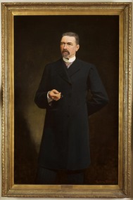 Parliament of Victoria
Portrait of Sir James Patterson, Coutts, Gordon 1865-1938, Premier James Patterson, 1893
Premier 23rd January 1893 – 27th September 1894. Born in Alnwick, England, Sir James Patterson (1833-1895) migrated to Victoria in 1852 to try his luck on the goldfields. After little success he turned his hand to farming, and later operated a slaughter yard at Chewton. Patterson served on the Chewton local council, being elected mayor four times before moving with his wife Anna and family to Melbourne in 1870. Patterson established a real estate business, and after two unsuccessful attempts to enter parliament in 1866 and 1868, he won the by election for Castlemaine in the Legislative Assembly in December 1870. He would hold this seat until his death 25 years later. Patterson served in Sir Graham Berry’s brief August to October 1875 government as Commissioner of Public Works and Vice-President of Board and Land Works. He repeated these roles two years later in Berry’s second government and additionally served as Postmaster-General, and in Berry’s third government was Commissioner of Railways and again Vice-President of the Board of Land and Works. In April 1889 after a time in Opposition, Patterson became Commissioner for Trade and Customs in Duncan Gillies’ Government. The following year he returned to the familiar positions of Public Works, Board of Land and Words and Postmaster-General. By 1891 Patterson was leader of the opposition, and when William Shiels’ government succumbed to a motion of no confidence, led by Patterson, he became premier on the 23rd of January 1893. During his premiership, James Patterson was also Chief Secretary and Minister for Railways. His term as premier coincided with a period of severe economic depression, and his enforced economies earned Patterson few public admirers. In May 1893 his government attempted to prevent a run on bank withdrawals and stabilise the sector, by declaring a 5 day 'bank holiday'. Patterson was awarded a knighthood in May 1894, however this did not increase public confidence in his government who were not returned to power in the August 1894 election. Again leader of the opposition, James Patterson died suddenly of influenza on the 30 of October 1895.This portrait was presented to Sir James Patterson by 'grateful citizens of Victoria' in appreciation of his services during the land boom depression. In 1929 the painting was donated to the Victorian Parliamentary Library by H. Lavinia Patterson, the wife of Sir James Patterson's nephew Colonel George Patterson.Oil on canvas, framed. Frame: ornate wood, gesso mouldings, unglazed. Signed on bottom right corner "G. Coutts" Stamped inscription along inner edge of canvas: "WINSOR AND NEWTON". Inscription on canvas, handwritten in ink: "13 1 92" from reverse.patterson, james brown (1833-1895) -
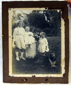 Orbost & District Historical Society
photograph, 1910 ?
George Nixon (1862-1941) selected land in Bete Bolong in the 1890's. He married Emily Warren in 1889 in Orbost. He was a shire councillor. He was a prominent breeder of Clydesdales and after a serious fall off a horse walked with a walking stick and special boot for the rest of his life. He was well-known for his interest in cars, horse-racing and politics. Mrs Nixon (Emily)was the first Red Cross president during WW1. They had ten children.both George and Emily are buried in the Orbost Cemetery. (ref:From White Knowle to Pumpkin Point by Hon Peter Nixon A.O.)George Nixon was the son of James and Alice Nixon. The Nixon families were among the earliest settlers on the Snowy River.A large black and white photograph which is glued on to a white paper frame and then on to brown cardboard. It is a photo of three children and a dog standing in a garden with a house in the background. The smallest child is sitting on a planter pedestal. The baby is Frederick Howard Nixon, the older girl is Essie Nixon.On back - George & Emily Nixon's family (Warren) Lexcine, Frederick, Esther In bottom RH corner - HDBphotograph family nixon-george -
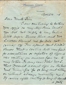 Warrnambool and District Historical Society Inc.
Document, Docket RF Kennedy, Letter written - 1908
This letter written by Mary Adams concerns the sale of a property, ‘my Hopkins land’, perhaps in the Warrnambool area. No information is available on Mary Adams or her ‘Uncle Jim’. There is a reference in the letter to ‘Mr Lawson’ and this may refer to a member of the Lawson family living in Warrnambool about this time, perhaps Richard Lawson who, in 1908, was Principal of a private school, Warrnambool College Academy. The Mountain Grand Guest House in Warburton was a well-known guest house in Victoria for many years and was still in existence in 1948. The letter came to the Society’s collection with other material relating to the Warrnambool Club. As no enlightening information is available on this letter or its contents it is of little importance at this time. Further research may render it a useful item to keep. This is a letter of two pages written in 1908 by Mary Adams to her Uncle Jim. The letter is handwritten in black ink. The letter is written on the green notepaper of the Mountain Grand Guest House Warburton, Victoria‘Mountain Grand, Warburton’ (on letterhead)mary adams -
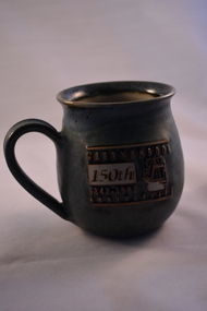 Warrnambool and District Historical Society Inc.
Household, Souvenir Cup (Warrnambool’s 150th ), 1997
This cup was produced by Ken Sadler as a souvenir of the 150th anniversary of the settlement of Warrnambool. Ken Sadler was a potter in Liebig Street, Warrnambool for many years (end of 20th century and beginning of 21st century). Warrnambool was founded as a planned town in 1847 to provide port facilities for the produce of squatters who had settled in the area. The town centre was surveyed by William Pickering at the request of Superintendent La Trobe of Melbourne and the first land sales were held in Melbourne in July 1847. The celebrations to mark the 150th anniversary of Warrnambool included concerts, race meetings, church services and the erection of an anniversary tablet on Cannon Hill. Ken Sadler, a well-known Warrnambool potter, made 500 of these cups which are now collectible souvenirs of the city’s 150th anniversary celebrations. This one retained by the Warrnambool and District Historical Society is numbered 189. The 150th anniversary of the founding of Warrnambool was an important event in the city’s history.This is a ceramic cup with a round base and larger rounded body with a round overhanging rim at the top opening. The cup is mottled green with an impressed image of a ship and lettering in white, gold and brown. There is some lettering on the bottom of the cup.‘Warrnambool 150th Anniversary 1847-1997’ ‘Sadler 97 189/500 Warrnambool’ warrnambool’s 150th anniversary, history of warrnambool, ken sadler, warrnambool potter -
 Eltham District Historical Society Inc
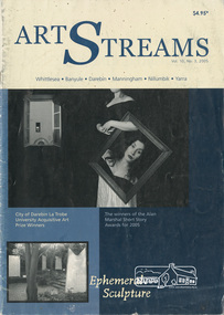
Journal, Peter Doughtery, ArtStreams: Vol. 10, No. 3, 2005
Vol. 10, No. 3, Jul-Aug 2005 CONTENTS Alan Marshall Short Story Award Winner 2 Ephemeral Sculpture 7 Food and a Question of Time - John Jenkins 10 Rhythm of the Land & Sea - Julie Tippene O'Toole 11 Silver Stars: A Mongolian Story - Lisa Edwards and Jenny Grinlington 12 Darebin La Trobe Art Prize 15 Jill Kahans mixes her media 17 Poetry 18 CD Reviews 19 Jack Henseleit - The Legend of Neil Douglas 20 Artin' About 21 Wining & Dining 26 Listings 28"Peter Dougherty has been involved in the local art scene for many years. As publisher and editor of the arts magazine Artstreams, his comments on the various branches of the arts are widely respected. His "The Arts" column in the Diamond Valley Leader presents a brief summary for a much wider cross section of the local community. Peter also operates his own gallery and the Artstreams Cafe at the St Andrews market. Peter has a wealth of knowledge about present day and historical aspects of local art and artists." - Eltham District Historical Society Newsletter No. 161, March 2005Colour front and back cover with feature articles and literary pieces with photographs and advertisements printed in black and white. 28 pages, 30 cm. Vol. 1, no. 1 (Nov. 1996) - Vol. 10, no. 5 (summer ed. 2005/06) art streams, art streams magazine, ephemeral sculptures, alan marshall short story award, click here to add keywords, darebin la trobe art prize, ephemeral sculpture, jack henseleit, jenny grinlington, jill kahans, john jenkins, julie tippene o'toole, lisa edwards, neil douglas, rhythm of the land & sea -
 Eltham District Historical Society Inc
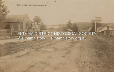
Postcard - Photograph postcard, Main Road, Greensborough, c.1910
View looking northeast along Main Street. The Greensborough Methodist Church stood at the present-day entrance to Greensborough Plaza shopping centre at 25 Main Street, Greensborough. It was opened in 1873. The Main Street Church served the congregation well, but by the 1960s it was decided to sell the old building and invest in a new home. The land at 37 Grimshaw Street for the current Uniting church was purchased in 1962 from the estate of Mrs White. Construction commenced on 31 July 1965 and the new church was opened on February 5, 1966. (https://www.churchhistories.net.au/church-catalog/greensborough-vic-uniting)Digital file only Postcards scanned from the collection of Michael Aitken on loan to EDHS, 2 Sep. 2022michael aitken collection, postcards, greensborough, main street, methodist church -
Glen Eira Historical Society
Article - Trinity Congregational Church, Glen Huntly
Handwritten undated notes (refer History of Primitive Methodism in Victoria and Tasmania – Rev. M Clarke). Article includes style of church building, history of building and interior decoration. Also includes history of some monetary donations, purchasing of land and church opening , small handdrawn map showing where church was before removal to current site. Reprinted articles from The Victorian Independant dated January 1910 and November 1909 on the opening of the Glen Huntly venture and the Revs who participated, and then the beginning of some committees, & Fellowship groups. Also mentions the appointment of Ivan Stebbins for six months.trinity congregational church, glen huntly, tennis, grange road, mercy g.g., bevan dr., primitive methodist church, dovan a. p. rev., holley j. j. rev., eastern road., freeman w, jones j. w. rev., south melbourne, griffith a. j. rev., devenish a. s. rev., lord. t, gosman dr, jones alfred., bryant. s, stebbins ivan, orr mr., billinghurst mr, copper mr, tregaskis mr., davidson mr., congregational hall, halls, wharington mrs., pavell g., rosstown, holden mr., bishop mr., sunday schools, white a. f., cockfield mr., orr mrs., billinghurst mrs., davidson mrs., o’ donnell miss, watkins miss., billinghurst miss., davidson miss., griffith mr., newing mr. -
 Glen Eira Historical Society
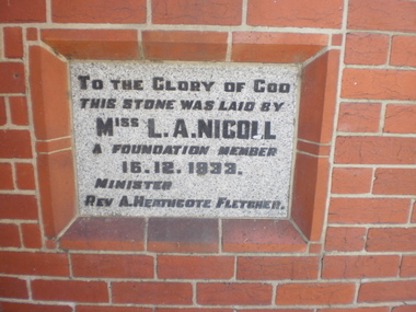
Article - St. Andrew’s Presbyterian Church, North Road, Gardenvale East
Handwritten document giving brief details on wording on foundation stone of St. Andrew’s church, undated and author unknown. Photocopy of pamphlet produced for the stewardship campaign 1957 for St. Andrew’s Presbyterian Church Gardenvale East, with several photos. It includes history as well as current situation at 1957. Photocopied notes and photo of the Army Hut used by Gardenvale Primary School in 1921 only as donated by church for and year then Reverted back to church use. Photocopy of letter to Glen Eira News and City Council re-proposed subdivision of church land from Robert W. Sinclair.st. andrew’s presbyterian church, foundation stones, nicoll l.a., heathcote-fletcher a. rev., north road, seach street, smith a. f.h. rev., mcneilage alex rev., gardenvale east, caulfield south, younger street, gardenvale east church, nicholls rev., rowlands w. rev., lang walter, sunday schools, yeaman f.e. rev., brown f.e., brick, towers, manse, choirs, groups, smith mrs., curtis e.e., morse roger, marryatt harry, pegler adrian, savill t., south caulfield, gardenvale primary school, sinclair robert w., dakin ms., campbell felicity -
 Eltham District Historical Society Inc
Slide - Photograph, Woodhaven Estate off Reynolds Road, Eltham, c.May 1988
The Age, Saturday, April 15, 1989, Page 72 OPEN SAT SUN 2-4 WOODHAVEN ESTATE A sample of house and land packages for your consideration: 3 br Ige rumpus $159,950 4 br tri level $169.9S0 4 br split level $169,500 Colonial with verandahs $199,950 Big 4 br dble garage $235,000 Huge exec 5 br S266.000 Meet our representative on site 2-4pm Sat and Sun in Booth Court, Eltham. off Reynolds Rd. Melway ref 22.E.335mm colour positive transparency (1 of 23) Mount - Kodak EktachromeProcess Date MAY 88Mmain road, eltham, housing estate, nicholas lauder real estate, woodhaven estate -
 Eltham District Historical Society Inc
Slide - Photograph, Incident Control Centre, Kangaroo Ground, Ness Lane and Kangaroo Ground-St Andrews Road, c.May 1988
The Age, Saturday, April 15, 1989, Page 72 OPEN SAT SUN 2-4 WOODHAVEN ESTATE A sample of house and land packages for your consideration: 3 br Ige rumpus $159,950 4 br tri level $169.9S0 4 br split level $169,500 Colonial with verandahs $199,950 Big 4 br dble garage $235,000 Huge exec 5 br S266.000 Meet our representative on site 2-4pm Sat and Sun in Booth Court, Eltham. off Reynolds Rd. Melway ref 22.E.335mm colour positive transparency (1 of 23) Mount - Kodak EktachromeProcess Date MAY 88Mincident control centre, kangaroo ground, kangaroo ground-st andrews road, ness lane -
 Seaworks Maritime Museum
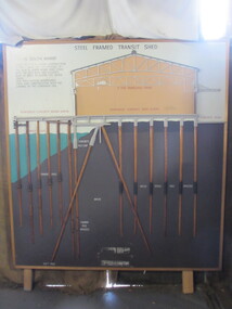
Diagram
Cross section of wharves and steel framed sheds built along the Yarra river between the 1920s and 1960s. The South Melbourne side of the Yarra River is reclaimed swamp land. Without a solid foundation for the construction of the wharves and transit sheds, extended piles were sunk into the mud to support the wharf and shed structures. An example of this design may be found at 5 South Wharf which was built in the 1930s. The transit sheds gave shelter for cargo while waiting to be loaded onto a ship or to be collected by truck after being unloaded from a ship. The transit shed became surplus to requirements with the introduction of containers.Wooden diagram of a transit shed featuring a shed sitting atop mud with some water. It shows the splices sitting in the mud to support the shed. "Steel Frames Transit Shed/ 15 South Wharf/ Model of Typical wharf construction/ of 1940- made for the opening of/ the "new" 15 South wharf shed (1944),/ Note the deep piles and elevated/ rear of the shed to allow for the truck/ trays./ This shed feature disappeared/ from port construction with the/ coming of the container era/ reinforced wharf apron/ 3 ton travelling crane/ reinforced concrete shed floor/ concrete road/ water level/ concrete pile cap/ cradled piles/ timber pile splices/ mud/ mild steel pile splices/ 110 ft pile" "On loan from Port of Melbourne Authority" -
 Greensborough Historical Society
Certificate of Title, Supreme Court of Victoria (Probate Division) et al, Certificate of Title Vol. 2567 Fol. 294, Vol. 3134 Fol. 605, 22/05/1895
Title Vol. 2567 Fol. 294 in the name of The Greensborough Estate Company Limited, 164 acres four and a half perches, being part of Crown Portion 17 Parish of Keelbundora, County of Bourke. Dated 22nd May 1895. Northern boundary Greensborough Road (now Grimshaw Street), Southern boundary Nell Street, Eastern boundary Plenty River, Western boundary road (now named McDowell Street); Title Vol. 3134 Fol. 605 in the name of Adolphe Frederic Seelenmeyer, land as described above, LP 4759 and transfers and other instruments to 9 March 1948Folder containing two Certificates of Title (3p. + 9 p.) and twenty pages of miscellaneous documents, including historical summary, brief biography of A. F. Seelenmeyer, two Death Certificates and photocopied extracts from probate documents, as listed in table of contents, ed. by Peter Simmenauergreensborough, greensborough estate company limited, grimshaw street greensborough, plenty river, nell street greensborough, mcdowell street greensborough, adolphe frederic seeley, formerly seelenmeyer, adolfe frederic seelenmeyer -
 Orbost & District Historical Society
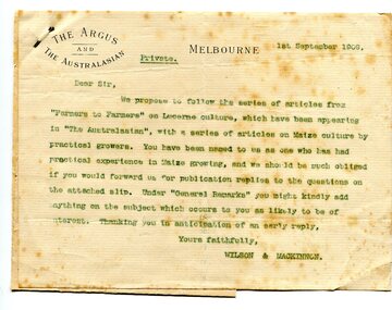
letter, September 1 1909
When early settlers began to arrive on the Snowy River somewhere in the 1880s, the land was mostly swamps and heavily timbered jungle on the river frontages. The swamps were drained bit by bit using hand tools. The frontages were cleared by axe and shovel and fire. Several kinds of crops were experimented with such as hops, hemp and maize. Maize grew particularly well and became the main crop of the district. (info. from October 2006 ODHS Newsletter) The Argus was a morning daily newspaper in Melbourne, Australia that was established in 1846 and closed in 1957. It was considered to be the general Australian newspaper of record for this period.Maize-growing has been an important agricultural industry in the Orbost district since early settlement. This item is associated with that history.A typed letter sent to a local maize farmer requesting information on maize growing. The letter has the "Argus" letter head. The name of the recipient is unknown.maize agriculture-orbost correspondence-argus