Showing 3723 items
matching office buildings
-
 Warrnambool and District Historical Society Inc.
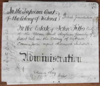
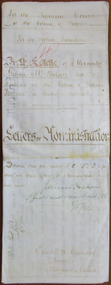
Document - John Fitts Letters of Administration 1879, 1879
No information has been found on the Commission Agent John Fitts except that he died at the Yarra Bend Asylum at the age of 51 and was formerly a resident of Ascot Vale, a suburb of Melbourne. His estate was valued at £600. Yarra Bend Asylum, near the junction of the Yarra River and the Merri Creek was the first institution for the mentally ill in Victoria and operated from 1848 to 1925. Tait collection: item 5 of 62This document is only of interest in that it came from the former legal offices of Mackay Taylor in Kepler Street, Warrnambool. It originally came from Thomas Goodall, a legal clerk in the office of the lawyer Ernest Chambers who passed it on to George Mackay, the lawyer in the forerunner firm of Mackay Taylor where it remained until the firm of Mackay Taylor ceased to exist and the buildings were cleaned out. This is a piece of parchment paper with printed black lines and handwritten material in black ink. There is a fold at the bottom of the document with a seal of the Supreme Court of the Colony of Victoria attached by a green ribbon. The document is slightly discoloured but is otherwise in good condition. ‘In the Supreme Court of the Colony of Victoria, Probate jurisdiction, In the Estate of John Fitts, late of the Yarra Bend Asylum, formerly of Ascot Vale in the Colony of Victoria, commission agent, deceased intestate, Administration, Edwards and Perry, Proctors’yarra bend asylum, john fitts, warrnambool -
 Warrnambool and District Historical Society Inc.
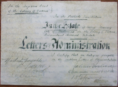
Document - George Murray Letters of Administration 1883, 1885
No information is available on George Murray except that he was a Melbourne accountant and died intestate in 1885. He left property to the value of £91 and the lawyer, Ernest Chambers, who was at that time at 12 Chancery Lane, Melbourne, was directed to list the creditors of George Murray and distribute the estate accordingly. Mr Chambers was one of George Murray’s creditors. Ernest Chambers later had a legal practice with offices at Warrnambool, Koroit and Port Fairy with the known dates 1897 to 1910. Thomas Goodall was the manager of the Warrnambool office and he was the one who had this document in his possession at that time and it was passed down to succeeding lawyers in the Kepler Street building. Tait collection: item 7 of 62This document is of interest in that it was originally issued by the lawyer Ernest Chambers who later had an office in Warrnambool. This is a piece of parchment containing the 1885 Letters of Administration in the estate of George Murray, a Melbourne accountant. The document is white with black ruled lines and has handwritten material in black ink. The document is folded at the lower edge with a seal of the Supreme Court of the Colony of Victoria. The seal is attached to the document by a green ribbon. There is also a blue stamp of the Master in Equity of the Supreme Court. The document is in good condition apart from some minor staining. ‘In the Supreme Court of the Colony of Victoria in its probate jurisdiction, in the Estate of George Murray, late of Melbourne in the Colony of Victoria, accountant, deceased intestate, Letters of Administration, I certify that no duty is payable on the within Letters of Administration, John W. … (office under section 6), 15/6/85’. george murray, ernest chambers, warrnambool -
 Warrnambool and District Historical Society Inc.
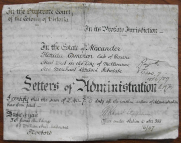
Document - Alexander F Cameron Letters of Administration 1887, 1887
This document concerns the estate of Alexander Florida Cameron, a seedsman from Melbourne in the firm of Grant and Cameron of 41 Bourke Street West, Melbourne. He died intestate in 1887 and left real estate to the value of £263 and personal estate to the value of £4744. This estate was to be administered by his son, Richard Ross Cameron. Tait collection: item 8 of 62This document has no apparent local significance and is of interest only as an example of the Letters of Administration issued in the 1880s. This is a piece of cream parchment with ruled black lines and the lower edge folded back with a seal of the Supreme Court of the Colony of Victoria attached to the document by a black ribbon. The document contains handwritten material in black ink and a blue stamp from the Revenue and Pay Office and a red stamp from the Master in Equity of the Supreme Court. The document is somewhat stained but is otherwise in good condition.‘In the Supreme Court of the Colony of Victoria in its probate jurisdiction in the Estate of Alexander Florida Cameron, late of Bourke Street West in the City of Melbourne, Seed Merchant, deceased intestate, Letters of Administration, I certify that the sum of £40-7-0 duty of the within Letters of Administration has been paid, Drake and Gair, 3 St. James Buildings, 59 William Street Melbourne, Proctors. W. Ravent Stephen, Office under Section 6, Act 388, 10/6/87’alexander florida cameron, drake & gair, solicitors, warrnambool -
 Warrnambool and District Historical Society Inc.
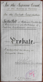
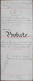
Document - William Bickle Probate 1900, 1900
Tait collection: item 20 of 62 This 1900 document gives details on the Will and Probate of William Bickle, described as a ‘Gentleman’, who died in April 1900. He left real estate to the value of £240 and personal estate to the value of £286. His wife Jane received the income from these assets during her lifetime and on her death the estate went to Bickle’s nephew and niece. The executors were John Warren, a painter of Jamieson Street, Warrnambool and Thomas Goodall, a law clerk of Warrnambool. No other details are available on William Bickle. Thomas Goodall was the manager of the law office of Ernest Chambers in Warrnambool. Chambers had offices in Port Fairy, Koroit and Warrnambool at the end of the 19th century and the beginning of the 20th century. This document is of interest because it contains information on the Will and Probate of William Bickle, a Warrnambool resident at the time of his death. The document was in the possession of the lawyer, Ernest Chambers and has been passed down to successive lawyers occupying the Kepler Street building. It was then passed on in 2014 to be part of the Warrnambool and District Historical Society collection.This is a 1900 piece of parchment paper folded in two with handwritten material on three sides. The seal of the Supreme Court of the Colony of Victoria is attached with a green ribbon and there are two stamps, one a red one of the Master in Equity of the Supreme Court, Melbourne and the other a blue one of the Savings Bank, Warrnambool. The handwriting is highly legible.william bickle, ernest chambers, tait collection, john warren -
 Warrnambool and District Historical Society Inc.
Document - Alexander Gibson McPherson Letters of Administration 1884, 1884
Tait collection: item 35 of 62 This is a document giving details of the Letters of Administration following the death of Alexander Gibson McPherson, a farmer of Rochester, Victoria, in December 1883. He died intestate and left an estate worth £215. The beneficiary was his sister, Mary Wright of Somerton. No other details are available on Alexander McPherson. The lawyer in the case was Ernest Chambers who had legal offices in Port Fairy, Warrnambool and Koroit at the end of the 19th century and the beginning of the 20th century. This document was in his possession at his Warrnambool office and passed down to successive lawyers occupying legal premises in Kepler Street. The document was found in the same building, the former premises of the legal firm, Mackay Taylor, where it was located in 2014 and handed over to the Warrnambool and District Historical Society.This document is only of interest as being originally in the possession of Ernest Chambers, a lawyer who was in Warrnambool for several years at the end of the 19th century. No connection between Warrnambool and Alexander McPherson has been found. This is a cream-coloured sheet of parchment paper, folded twice. It contains hand written material in brown ink giving details of the Letters of Administration following the death of Alexander McPherson of Rochester in 1883. A seal of the Supreme Court of Victoria is attached with a green ribbon and it has ,a black stamp of the Master in Equity of the Supreme Court of Victoria. One page has been ruled at the edges with brown lines. The writing is somewhat faded but the document is legible. In the Supreme Court of the Colony of Victoria in its probate jurisdiction in the Estate of Alexander Gibson McPherson late of Rochester in the Colony of Victoria Farmer a bachelor deceasedalexander mcpherson, ernest chambers, warrnambool, tait collection -
 Warrnambool and District Historical Society Inc.
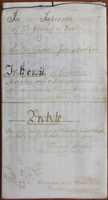
Document - David Williams Probate 1889, 1889
Tait collection: item 36 of 62 This document contains the details of the Will and Probate of David Williams of ‘Morgrugyn’ farm near Woodford. He was born in 1804 and died in 1889. He was a pioneer settler in the Woodford area, arriving, according to the Pioneer Honour Board, in 1842. His son, Ivor, was Secretary of the Grasmere Cheese and Butter Factory for some time and Secretary of the Warrnambool Cheese and Butter Factory in 1888. David Williams left real estate to the value of £1540 and personal estate to the value of £1075. The chief beneficiary was his eldest son, David but other sons and grandsons also benefited. His wife, Mary, was left £300, a house to live in rent free during her lifetime, two cows and the right to graze them on the farm, six silver spoons, her bed and bedding, washstand and ware, a dressing table, a table in the dairy and ‘all the crockery and cooking utensils she may require’. The lawyer drawing up this document was James Fletcher who had an office in Port Fairy in the 1870s and an office in Koroit Street, Warrnambool, in the 1880s. In the 1890s and early 1900s he was in partnership with George Mackay. This document was in the possession of the lawyer Ernest Chambers who had drawn up the Williams will. It was then passed down to successive lawyers occupying legal premises in Kepler Street until it was located in 2014 in the Kepler Street building last used as legal premises by the firm of Mackay Taylor. This document is of considerable interest as it contains the will and probate details of a prominent 19th century farmer in the Woodford district. It will be useful for researchers.This is a white piece of parchment paper folded in two with typed material on two pages and handwritten material on one page. The pages are ruled with red ink. The pages include the Will and Probate details of David Williams of ‘Morgrugyn’ farm near Woodford. He died in 1889.In the Supreme Court in the Colony of Victoria in the Probate Jurisdiction In the Will of David Williams Morgrugyn farm near Woodford in the Colony of Victoria Farmer deceasedjames fletcher, david williams, ernest chambers, warrnambool, woodford, morgrugyn farm -
 Warrnambool and District Historical Society Inc.
Document - Caroline Manton Probate 1889, 1889
Tait collection: item 37 of 62 This is a document giving details of the Will and Probate of Caroline Manton who died in 1889 and was the wife of Frederick Manton and lived at ‘Tenilba’ in Domain Street, South Yarra. She left personal estate to the value of £536 for the benefit of her husband and children but no other details on her life have been found. The lawyer in the case was Ernest Chambers who had legal offices in Port Fairy, Koroit and Warrnambool at the end of the 19th century and the beginning of the 20th century. This document was in his possession in his Warrnambool office and it was passed down to successive lawyers in the legal premises in Kepler Street, Warrnambool and located in 2014 in the same building, the former legal premises of Mackay Taylor. This document is of minor interest as it does not appear to have any relevance to local Warrnambool history except that the lawyer involved had legal offices in Warrnambool.This is a cream-coloured parchment paper of three pages stitched together with black cord. There is handwritten material written in brown-coloured ink on five pages. The seal of the Supreme Court of Victoria is attached with black ribbon. The ink on the front page is fading and difficult to read.caroline manton, ernest chambers, tait collection -
 Warrnambool and District Historical Society Inc.
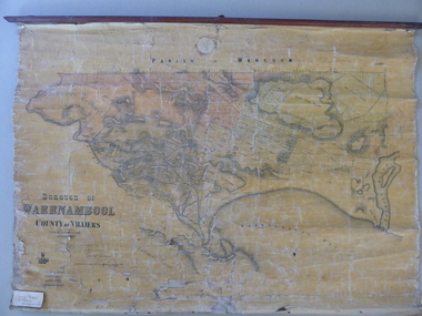
Mao, Borough of Warrnambool, County of Villiers, 1873
This is an early map of the Borough of Warrnambool (1872/3) showing the central town area of Warrnambool and the surrounding district. Reserves, public buildings and some businesses are marked. The map was photolithographed by John Noone, a Melbourne artist and photographer who claimed in 1858 to have the oldest-existing photographic studio in Melbourne. Photolithography was a process first developed in Melbourne. For several years Noone was the official photographer for the Victorian Crown Lands Office and for the Victorian Public Library and Museum. The map has the stamp of the seller of the map – Charles Hider, the well-known stationer and bookseller in Timor Street, Warrnambool. The owner of the map, Henry George Marfell, (1883-1962) was the son of John and Mary Ann Marfell. The Marfells were well-known in Warrnambool as grain merchants and managers of the Warrnambool Co-Operative Milling Company. It is surmised from the writing on the Marfell label that this map was at some stage given by Henry Marfell to the old Warrnambool MuseumThis map of early Warrnambool is of considerable significance, firstly because its original state and early date (1873) make it of antiquarian and historical interest. Also the connection with the names, Charles Hider and Henry Marfell and the old Museum gives it added provenance and interest.This is a wax paper map mounted on cloth. At the top it is attached by nails to a piece of wood and at the top it has a cloth ring for hanging the map. The map is in black shadings on a yellow background. The map is badly creased and coming away from the cloth at the edges and at other various points. There is some red or pink marking or staining on the township area of the map (originally the sold lands on this map were coloured in brown and the reserves, buildings, etc in pink). On the left hand corner there is a piece of paper glued on with some handwriting in ink (Marfell). There is also the stamp of the seller of the map – Charles Hider, stationer and bookseller, of Timor Street Warrnambool‘Early Map of W’bool, H.G. Marfell’ history of warrnambool, charles hider, henry marfell -
 Warrnambool and District Historical Society Inc.
Documents, Swintons Paper att 18/53 Merri St. Contract. Map. Notes, 1959
These documents relate to the sale of land in Merri Street Warrnambool in 1959 by Swintons Pty Ltd of Warrnambool. The buyer of the land was George O’Grady, a Warrnambool baker. The land sold for £4000 and there was a shed on the land (called the ‘Office’) which George O’Grady indicated he wished to be included in the sale. William and Ann Swinton migrated to Australia in 1854 and for a decade William Swinton worked as a builder and carpenter in the Warrnambool area, erecting many buildings, including the Wangoom Presbyterian Church. In 1865 he opened a store in Timor Street Warrnambool, selling groceries, hardware, china and glassware. By 1888 the business was known as William Swinton and Sons. Branch stores were opened in Wangoom, Cudgee, Nullawarre, South Warrnambool and West Warrnambool. After William Swinton died his son Robert became the first managing director of Swintons Pty Ltd. In 1934 the business split with George Swinton and Sons selling clothing, furnishings and glassware and Swintons Pty Ltd selling seeds, produce and hardware. Today the Swinton family still operates a furniture and bedding shop in Timor St Warrnambool.These items are of some interest as being connected to the Warrnambool business of Swintons Pty Ltd. They will be of interest to researchers. The current Swinton business in Timor Street is the oldest family business in Warrnambool and, with the name Swinton associated with businesses in Timor Street Warrnambool for 152 years it is amongst the oldest family businesses in Australia.The items here relate to the sale of land by Swintons Pty Ltd., Warrnambool. .1 These are three pages of white paper with typed material, a lawyer’s signature in blue ink, one green stamp and a sketch of the land location. .2 This is a sheet of thick paper containing a plan of the land sold. The paper has printed material and a sketch of the land with part of it coloured in pink. .3 This is a small piece of paper torn at the bottom right edge. It has handwritten material (a letter) in blue ink..2 ‘Plan of Survey of Part of Crown Allotment 18 Section 3 Township of .2 ‘Plan of Survey of Part of Crown Allotment 18 Section 3 Township of Warrnambool Parish of Wangoom County of Villiers’ .3 ‘Tuesday Dear Mr Swinton I am writing to say that I would like to have the ‘Office’ Thanking You George O’Grady’swinton family,, warrnambool -
 Kiewa Valley Historical Society
Photographs x 2 1. Lake Guy & Bogong Village 2. Bulldozer moving rocks
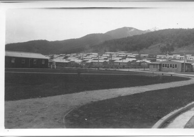
1. In 1940 Field Headquarters for the Kiewa Scheme were established at Bogong with office, workshop facilities and accommodation for workmen, staff and some families constructed. (There had been a 'tent camp' on this site in 1939 but was destroyed by bushfires) Construction of accommodation continued until 1947. A total of 40 houses plus a hostel for single staff, post office, police station, medical centre and primary school all with water and sewerage and electricity supply. The staff hostel was known as Kiewa House and is now occupied by the Education Department. Lake Guy was named after Mr. L.T. Guy who was the Resident Engineer in charge of construction work and associated activities on the Kiewa area. He held this position from 1939 to November 1946 when he was transferred to Head Office. 2. Example of the type of heavy machinery used in clearing and building of Lake Guy, Bogong Village and Clover Dam 1. The Bogong Township was developed firstly as an accommodation centre (base camp) for construction workers employed under the Kiewa Hydroelectric Scheme. At the completion of the scheme, in the 1960's, the village was opened to public/tourism use. Strict environmental control has not allowed for any extensive redevelopment in tourist accommodation and basically restricted it to the accommodation initially built for the construction workers. Lake Guy is one of the many water storage reservoirs used to supply the power stations their main power to run the huge turbines generating the final product, electricity 2. Pictorial record of the types of machinery used in the development of Bogong Village and the Hydro-electricity scheme including the Clover Dam. Note the lack of safety equipment worn by construction workers of the period. 2 black and white photographs taken at Bogong 1. Lake Guy with Bogong Village in the background 2. Workman in bulldozer clearing rocks, possibly for construction at Bogong1. Handwritten in blue ink on back of photo 'Lake Guy showing Bogong Village' 2. No markingslake guy, bogong village, secv -
 Kiewa Valley Historical Society
Photographs –Collection of 10 copies and original black and white photographs and printed articles relating to skiing on the Bogong High Plains
After World War II, the Kiewa Hydro-Electric Scheme was started in the Kiewa River Valley by the State Electricity Commission of Victoria. On land previously used only for summer cattle grazing in the natural alpine grasslands, the first ski lodge was built in 1948 by workers from the hydro scheme as skiing was a popular recreation. Many of the hydro employees were of European background and had grown up enjoying skiing and snow sports in their homelands and were keen to continue to pursue their winter sports interests. The first lift, a rope tow, was built in 1951 at Falls Creek and the first chairlift in Australia was constructed there in 1957. Two T-Bars were opened in 1961. In 1964, the Victorian Municipal Directory recorded that Falls Creek had 29 ski club lodges and 16 commercial lodges. The area became a popular tourist destination for both winter and summer sports.: Employees of the State Electricity Commission of Victoria in the Kiewa River Valley were the earliest skiers on the Bogong High Plains and built one of the first ski lodges at Falls Creek. They were amongst those pivotal in the development of the skiing and tourist industry at Falls Creek and on the Bogong High Plains. Collection of 10 copies and original black and white photographs and printed articles relating to skiing on the Bogong High Plains. Some pieces have been enlarged to A3 poster size copies for display purposes 1. Copy of black and white photograph of group of skiers at Falls Creek 2. Copy of photograph of early skier on Bogong High Plains with temporary buildings and tents in the background 3. Copy of photograph of 3 skiers on Mt McKay 4. Copy of SECV photograph of Rocky Valley Camp under snow 5. Early sepia photograph of Falls Creek village with skiers in the foreground 6. Copy of a page from booklet (SECV?) promoting the benefits of owning a holiday home in the Bogong Village area 7. Copy of a page from booklet (SECV?) promoting the benefits of holidaying in and around Falls Creek/Mt Beauty 8. Panoramic view of ski fields with skis in the foreground 9. Photograph of young skier (identity unknown) 10. Photograph of 2 male skiers (identity unknown) performing a small jump 1. Bogong Ski Club Members & Friends 1944 2. Jack Neve – electrician. Rocky Valley 3. 17.5.55 Skiers ascending Mt McKay 4. State Electricity Commission of Victoria. Date:17.8.55 No:K8132 Kiewa Hydro Electric Works. Rocky Valley Camp – From Engineering Office 5 & 9 No markings 6 & 7 Short article relating to photos on each page 8. Handwritten signature on rear of photo (Sandra Conea) 10 Faded unreadable photographers stamp and handwritten numbers 6875 on rear secv; bogong high plains; skiers; falls creek; tourism -
 Kiewa Valley Historical Society
Photographs – Set of 9 black and white photographs and photocopies of original photographs depicting the early days of Bogong Village during the 1940’s, circa 1940's
Bogong Village, which was known as “The Junction”, is well recorded. The first tent camp was at the junction of Pretty Valley and Rocky Valley streams in the early 40’s. Further downstream were the sawmill, stables and blacksmith’s forge. Horses were the main mode of transport in the early days. The road to Bogong had reached the lookout spur just beyond Roper’s Spur track just before the 1939 fires. The early forties saw rapid growth of the village, with single and married men’s quarters, workshops, mess huts and administrative offices. The facilities necessary for communal living were quickly in place- a post office, police station, co-op store, medical centre, community hall/theatre, tennis courts and school. Much of the temporary accommodation that housed groups such as the Albion Quarrying Company were in the area now under water.Pictorial history of the early years of Bogong Village including one photo taken following the devastating fires of 1939. Photos show the terrain in which Bogong Village was built, the early construction used for the temporary buildings and the housing and the amount of infrastructure required to accommodate the needs of the residents of the area including workers, their families and other support staff. Set of 9 black and white photographs and photocopies of photographs depicting early buildings at Bogong Village . Photos show very early construction buildings as well as the village in various weather conditions, including snowing and after bush fires. (some official SECV photographs) 1. Bogong Village in heavy snow 2. Bogong Township during heavy snow (SECV Official Photo) 3. VIP Lodge at Bogong in the snow 4. Bogong Village - circa 1940’s 5. Bogong Village under street lights 6. Lewis Construction Camp (SECV Official Photo) 7. Albion Quarrying Co. Camp (SECV Official Photo) 8. Tent camp and early buildings following 1939 fires 9. Typical house – Bogong Village 1. Handwritten under photo – August 1948 2. Printed under photo: STATE ELECTRICITY COMMISSION OF VICTORIA Date: 25.8.48 Time: 9am No:K 4680 Kiewa Hydro-Electric Works. Bogong Township 3. Handwritten on back of photo- V.I.P. Lodge, Bogong 4 – 5. No markings 6. Printed under photo: STATE ELECTRICITY COMMISSION OF VICTORIA Date: 28.11.40 Time: 1.40pm No:K284 Kiewa Hydro-Electric Works. Lewis Construction Camp 7. Printed under photo: STATE ELECTRICITY COMMISSION OF VICTORIA Date: 11.1.41 Time: 10.40am No:K294 Kiewa Hydro-Electric Works. Albion Quarrying Co. Camp – Bogong. Handwritten on back of photo: On the floor of the present dam 8. No markings 9. Printed under photo: STATE ELECTRICITY COMMISSION OF VICTORIA Date: 11.1.46 Time: 1.23pm No:K2181 Kiewa Hydro-Electric Works. Bogong – Typical House bogong village; 1939 fires; kiewa hydro electric scheme; -
 Kiewa Valley Historical Society
Photograph - Folder of Photographs – Photocopied set of 10 black and white photographs (pages 19 - 28) from the display folder put together by KVHS to document life on the Kiewa Valley Hydro-electric Scheme
Although the Kiewa Hydro-Electric Scheme was first proposed in 1911, construction did not commence until 1938. As part of the push to cut electricity costs and diversify supply, the Victorian Government (circa 1930) initiated the conversion from primarily brown coal supply to hydro – electricity. Field investigations during the 1940’s resulted in a new proposal for a scheme that had more than double the capacity of the 1938 scheme. The Kiewa Hydroelectric Scheme became the largest scheme of its kind in the State Of Victoria and the second largest scheme in Australia. The number of personnel involved in the planning and construction of the scheme increased dramatically. During the late 1940’s, most activity centred around the construction of the West Kiewa Power Station, Rocky Valley Reservoir, McKay Creek Power Station and the Bogong Creek Aqueduct.A common thread across all the larger hydro scheme constructions was the need for workers, both qualified and unqualified who came from around the world seeking a new life for themselves and their families. New accommodation and facilities were required for the army of workers engaged in construction in often remote and wild areas. The SEC had a high demand for timber, and set up the first of a number of sawmills at Bogong Creek in 1939 and set up the first hardwood logging in the headwaters of the Kiewa River. These new ‘towns’ such as Mt Beauty and Bogong, survived, serving the needs of operational personnel and their families, and expanding with growth of new industries. Mount Beauty, and to a lesser extent Bogong, are among these places. Large A3 size spiral bound display folder containing 21 pages of photocopied black and white photographs of various aspects of the early days of the Kiewa Valley Hydro-electric scheme including equipment, various work sites and photographs of workers and their families. 1-Allis Chalmers Tractor School 2- Gardens outside Administrative Office – Mt Beauty 3- Mt Beauty house – 1950 4-Bridge over Pretty Valley River, Bogong 5-Rocky Valley Spillway Tunnel break through 6-Ni 1 Headrace Tunnel drilling face 7-No 4 Power Station Drilling 8-Clover Dam Flood Waters 9-No1 Head Race Tunnel Portal Building 10-Clover Dam 1-STATE ELECTRICITY COMMISSION OF VICTORIA Date: 5.9.49 Time: 10amm No K5174 Kiewa Hydro Electric Works Allis Chalmers Tractor School Page number 19 2-STATE ELECTRICITY COMMISSION OF VICTORIA Date: 22.2.50 Time: 3.30pm No K5601 Kiewa Hydro Electric Works Gardens outside Administrative Office – Mt Beauty Page number 20 3-Mt Beauty house – 1950 Page number 21 4-STATE ELECTRICITY COMMISSION OF VICTORIA Date: 23.10.50 Time: 11.15am No K6331 Kiewa Hydro Electric Works Bogong-Bridge over Pretty Valley River Page number 22 5-STATE ELECTRICITY COMMISSION OF VICTORIA Date: 23.6.50 Time: 2.30pm No K5844 Kiewa Hydro Electric Works ROCKY VALLEY SPILLWAY TUNNEL BREAK THROUGH Page number 23 6-20/3/52 – No. 1 Headrace Tunnel Drilling face (E.E.E. contract) Page number 24 7-6/6/52 – No 4 Power Station – Drilling Page number 25 8-STATE ELECTRICITY COMMISSION OF VICTORIA Date: 6/6/52 Time: No K7113 Kiewa Hydro Electric Works Clover Dam Flood Waters Page number 26 9-STATE ELECTRICITY COMMISSION OF VICTORIA Date: Oct 1952 Time: No K7239 Kiewa Hydro Electric Works No. 1 HEAD RACE TUNNEL PORTAL BUILDING. Handwritten underneath – This information from Ron White-the later Principal Hydro Engineer of the SEC. Oct 1952 Location incorrect? All work on No 1 had ceased after financial crash of 1951. This photo would refer to No 4 Headrace Tunnel? Page number 27 10-STATE ELECTRICITY COMMISSION OF VICTORIA Date: Jan 1953 Time: No K7307 Kiewa Hydro Electric Works CLOVER DAM Page number 28 secv; kiewa hydro electric scheme; bogong; mt beauty; construction area -
 Kiewa Valley Historical Society
Photographs - Townships of Mt Beauty and Bogong and the Kiewa Valley, c 1940, 1950, 1960
The township of Mt. Beauty was built to provide family accommodation for personnel working on the construction of the Kiewa Scheme. construction commenced in 1946. Photo 1 is looking towards the corner of Lakeside Ave. and Kiewa Crescent. The Post Office is on the corner and the original building housing the Co op store was in Kiewa Crescent. Photo 2 is taken at a later date as the garden in front of the Post Office is well established. The Community Centre is centre left of the photo and the back buildings are the staff accommodation called "The Chalet". Photo 3. Farming country taken from Wallacedale. The Wallaces were one of he early farming families in the Kiewa Valley. Photo 4. This photo is of Junction Camp at Bogong Village and was commenced late in 1939 and by 1940 accommodated 96 men who were engaged in work on Junction Dam. Sleeping accommodation was provided in hutments, each of four rooms, each room being approx. 12 feet by 10 feet and provided for the accommodation of 2 men. This camp remained in use until November 1962.These photos have both historical and social significance. They show the type of accommodation available for workers during the construction of the SEC Kiewa Hydro Scheme as well as early streetscape views of Mt. Beauty. The Junction Camp photo also shows the state of the forest following the 1939 fires in the area.4 Black and white photographs of various sizes.Photo 1. On back, hand written in pencil: top left hand corner: "Sept 1950". Centre of photo: "Return to Gibson Envelope". Right hand side: "Cooper". Bottom left corner: "Mt. Beauty Camp SEC Kiewa Scheme". Photo 2. No inscriptions or markings. Photo 3. Back of photo handwritten in pencil: "In W>T> June 14. 1961 page31. Some of the farming country in the Kiewa Valley. This taken from the home of Mr. Geoff Wallace Wallacedale, Kergunyah where some of his 600 cattle were rounded up." Bottom right corner "Return to Gibson Envelope". There is a copyright stamp belonging to "the Herald & Weekly Times Ltd. also on the back. Photo 4. Typed on a sticker on the back of the photo "Stable attendants Cottage and Camp Sept. 1940".camp, sec kiewa scheme, kiewa, cattle, mt. beauty -
 Warrnambool and District Historical Society Inc.
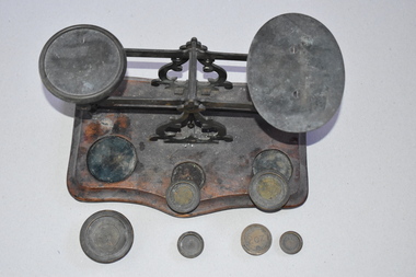
Scales, Nullawarre PO tray & 6 weights, Early 20th century
These scales come from the Nullawarre Post Office. Nullawarre is a small settlement 25 kilometres south east of Warrnambool. The area was settled in the late 1860s and 1870s and the first school was opened in 1878. The main agricultural pursuit in the Nullawarre district is dairying. The Nullawarre Post Office still operates in the General Store building. This set of scales is of interest as it is a memento of the equipment used in country Post Offices one hundred years ago or more. Scales such as these may still be in use but electronically-operated scales are more likely to be used today.This is a set of metal weighing scales with two trays, one oval in shape and one round, on a balancing mechanism. This mechanism has two ornamental upright metal pieces. The scales are affixed to a wooden base in a rectangular shape with the front edge shaped into two curves. The wooden base has three slots for holding the weights. There are six brass weights with this item. The metal is a little tarnished and the wooden base is stained. nullawarre, history of warrnambool -
 Warrnambool and District Historical Society Inc.
Artefact, Inkwell, 1920
... century. It was probably used in an office or business building ...This ink well could have been for household use but was more likely to have been used in an office or business. No information has been found on the name on the base – A.R. McLachlan. Ink wells began to be less used when fountain pens came into general use in the 1940s and went out of use completely when ballpoint pens became the popular writing instrument in the 1950s. This ink well is of interest as an example of the ink wells used early in the 20th century. It was probably used in an office or business building. This is a metal container with a circular base and an upright circular tube in which is inset a china ink well. The ink well is covered with a hinged metal lid and there are four round holes around the lid area. Both the lid and the base are etched with circular ridges. ‘A.R.McLachlan 1920’ office equipment, warrnambool, history of warrnambool -
 Warrnambool and District Historical Society Inc.
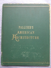
Book, Palliser's American Architecture, 1888
This book contains many late 19th century designs from the office of the American architects Palliser, Palliser and Co. The book was owned by John Crawley. He was the Shire of Warrnambool Engineer from 1895 to his death in 1935. He succeeded his father, also John, beginning work at his father's office in 1885. This book is of antiquarian interest because it has many examples of the designs of the private and public buildings in U.S.A. in the late 19th Century. It is also important because it belonged to John Crawley, a member of the Crawley family, prominent in administrative and technical positions in the Shire of Warrnambool in the 19th and 20th centuries.This is a hard cover book of 104 pages. The cover is green with gold borders and gold lettering. The book has come apart from its binding and the lower part of the spine covering is missing. The book has many black and white illustrations, plans and diagrams and a list of the prices for the designs in the book. The inscription is hand written in black ink. There is some evidence of silverfish damage.J Wm Crawley Junior 12.12. 98crawley family, shire of warrnambool, john william crawley junior -
 Warrnambool and District Historical Society Inc.
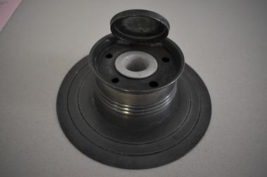
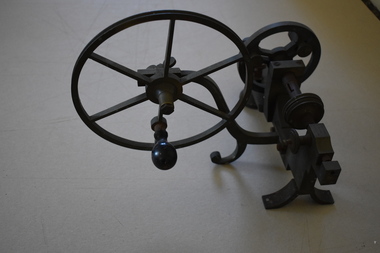
Tools, George Panton & Sons, Jeweller Lathe, Early 20th century
This jewellery lathe (minus its rubber belt) came from the Warrnambool jewellery store of Michael Salamy and his son, Edward. The business was in two locations - in Timor Street, opposite the old Post Office, and at 179 Liebig Street. Michael Salamy erected two new buildings at 179 and 181 Liebig Street and the Salamy business was then headed by the son, Edward who was born in 1903 and died in 1977. The jewellery store was closed when Edward retired and Clancey Brothers men's store took over the building at 179 Liebig Street in 1966. Bill Clancey found the jewellery lathe in this building and donated it to the Historical Society. This lathe is of considerable interest as it comes from the prominent 20th century Warrnambool jewellery business of M.Salamy and Son. It is also an interesting memento of a 20th century industrial tool. This is a metal tool with several wheels connected with wing nuts. The large wheel has a wooden handle. A rubber belt connecting two of the wheels is missing. '0865 Panton Maker Glasgow'michael salamy and son, jewelers, warrnambool -
 Warrnambool and District Historical Society Inc.
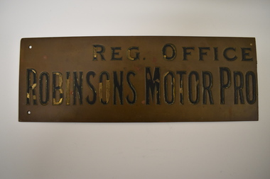
Business Plate, Robinsons Motor Pty Ltd, Early 20th century
This plate was probably shortened to fit an office or factory door. Alexander Robinson (1862-1932) established a coachbuilding business in Fairy Street Warrnambool in 1880. In 1883 he joined with Fred Morse to set up the coachbuilding business of Robinson and Morse. This firm was noted for its production of fine Abbott buggies. Later Morse established his own business in Warrnambool and Robinson’s business continued at Fairy Street and converted to motor car building in the early 1900s. Alexander Robinson was Mayor of Warrnambool from 1907 to 1909. In the early 1930s Robinson’s Motors was replaced by Callaghan Motors. This business traded on the Fairy Street site until 2018 but now operates from Raglan Parade. The grandfather of one of the donors of this item, Tom Smith, worked at Robinsons Motor Pty Ltd in the early 20th century. This plate is of great interest as it came from the motor car business of Robinson’s Motor Pty Ltd. The Robinson businesses (coach building & motor car building) existed in Warrnambool for over 50 years. This is a brass business plate with three small holes at each corner. The lettering etched on the plate is gold and black but the black may have been put on to the lettering at a later stage as only some of the gold lettering is still visible. The plate has been cut off on one side and part of the lettering is missing.‘Reg. Office’ ‘Robinsons Motor Pro..’ robinson & morse, history of warrnambool, robinson’s motor pty ltd, alex robinson, warrnambool -
 Warrnambool and District Historical Society Inc.
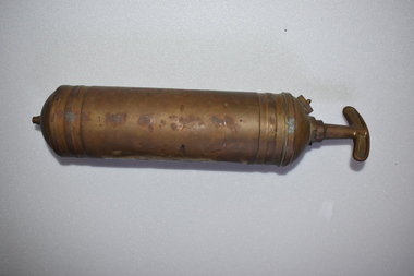
Fire Extinguisher, Pyrene Co Ltd, Mid 20th century
This fire extinguisher was used for commercial purposes in the Nullawarre Post office. The item was made in England by the Pyrene Co Ltd (1914-1971), one of the world’s leading manufacturers of fire fighting equipment in the early to mid 20th century. The extinguisher had a pump action and probably contained carbon tetrachloride. Nullawarre is a small agricultural settlement 25 kilometres south east of Warrnambool. The Nullawarre area was settled in the late 1860s and 1870s and today has a store and Post Office and a school. Charles Williams was the Post Master at Nullawarre in the early to mid 20th century and also delivered the mail. His wife, Vida was the Post Mistress. This fire extinguisher is of interest firstly as an example of a common item used commercially in the past and secondly as an item that came from the Nullawarre Post Office, used in this commercial building in the early to mid 20th century. This is a metal fire extinguisher which has been painted but the paint is mostly worn away. It is cylindrical in shape with ridged areas at the base and top. It has a clip handle. The cylinder is empty.‘Pyrene’vintage fire extinguishers, nullawarre post office, warrnambool -
 Port of Echuca
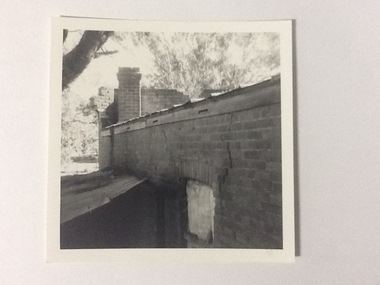
Black and white photograph, 1975
The brick old Murray River Sawmill office was demolished around 1975. This photograph is of the side of the building taken from behind. It shows a corrugated lean-to and a window or door way that appears to be blocked off. There is a large crack in the brick work wall beside this doorway. Part of the back of the front brick facade is visible behind a brick chimney. This relates to photographs P000106, P000107.Sawmills in the Echuca area were historically and socially significant being a large employer in the area. The Murray River sawmill was one of the biggest and longest operating sawmills in the area.Black and white photograph of the old Murray River Sawmills building, taken from the road. Shows view from a rear side, with a window and corrugated iron lean-to. Part of back of facade can be seen as well as the chimney.On back of the photograph in pencil "Old Murray R Sawmills bldg, in from road." In black pen "Old office demolished c.1975" stamped in blue ink "0932"murray river sawmills, echuca, sawmills, echuca, vicotria, pullicino, j -
 Port of Echuca
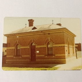
Colour photograph, Approx 1979
Customs building: built 1884 to handle goods entering Victoria up to 1901. Building classified B by National Trust.Customs houses, of similar design, were built along the Murray river to collect taxes on goods transported from N. S. W. to Victoria. The taxes were collected up until Federation in 1901. The Victorian railways used it as an office until about the 1960 when it became a private dwelling. The Customs House at Echuca is now owned by The Port of Echuca and has been used to house a wine tasting businesses, cafe and local produce retail and art gallery.Colour photograph of Customs House at Echuca port.In ink on reverse: "8A"customs house, echuca, echuca historical buildings, echuca, port of (customs history) -
 Port of Echuca
Colour Photograph, Approx.1979
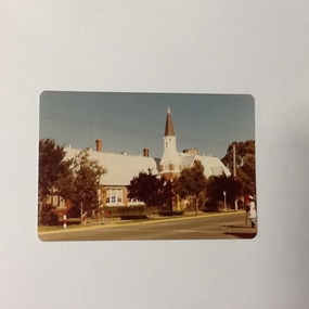
This building opened on 19 October 1874. The front section of this building including 8 classrooms, the headmaster's office and the bell tower were destroyed by fire 27 February 1890. "The burnt section of the school was rebuilt along the lines of the original building and today the red brick facade and bell tower are a feature of the Hare Strett skyline" (Echuca Stetchbook, Blyth, I, 1978, p.32.Henry Hopwood, founder of Echuca, saw the need to establish a national school to educate the children of Echuca. The first National School opened in October 1858 in a framed tent. Construction of the first brick school house began in 1859 on the site of the original Post Office in Hare street. Later the site changed to the southern end of Hare street and this building was opened 19 October 1874. The school stayed here until a new school was built on the old Echuca Technical School site.Colour photograph (post-card size) of Echuca Primary School, 208, showing the eastern facade including the bell tower, taken from the eastern side of High street. Printed on the reverse:"this paper manufactured by Kodak"echuca-primary schools, echuca-historical buildings -
 Port of Echuca
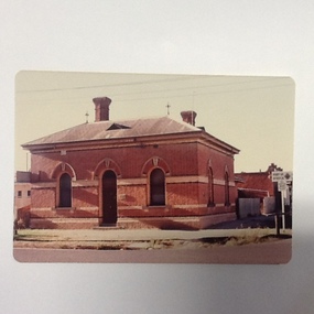
Colour photograph, 1977
Customs building: built 1884 to handle goods entering Victoria up to 1901. Building classified B by National Trust.Customs houses, of similar design, were built along the Murray river to collect taxes on goods transported from N. S. W. to Victoria. The taxes were collected up until Federation in 1901. The Victorian railways used it as an office until about the 1960 when it became a private dwelling. The Customs House at Echuca is now owned by The Port of Echuca and has been used to house a wine tasting businesses, cafe and local produce retail and art gallery.Colour photograph of Customs House at Echuca port.In ink on reverse: Dec.77-M: Print made by Kodak: Kodak. In pencil Customs Housecustoms house, echuca, echuca historical buildings, echuca, port of (customs history) -
 Warrnambool and District Historical Society Inc.
Badges, Manchester Unity, Mid 20th century
The MU on these badges stands for Manchester Unity Independent Order of Oddfellows. This was one of the most prominent of the benefit societies operating in Warrnambool over the years. Originating in England, Manchester Unity I.O.O.F. was established in Warrnambool in 1860. This benefit society built and opened the Oddfellows Hall in Koroit Street Warrnambool in 1869 (building still extant but now used for office space). Some years ago the Manchester Unity I. O.O.F. joined with the Australian Natives Association to form a new benefit group, Australia Unity. These badges are of interest as mementoes of a benefit society that was prominent in Warrnambool for over 100 years..1 A round metal lapel badge with gilt edging, an outer blue band and the letters ‘MU’ in blue and red on a gold-coloured background. The stud clip is at the back. .2 As above except that it has a long stick pin attached to the back instead of a stud. MUmanchester unity independent order of oddfellows, benefit societies in warrnambool, history of warrnambool -
 Eltham District Historical Society Inc
Photograph - Digital Photograph, Alan King, Original Kangaroo Ground Primary School No. 2105 building, Eltham-Yarra Glen Road, Kangaroo Ground, 28 December 2007
Kangaroo Ground's first school began in 1851 with 22 pupils from the district's ten families. It was a single room school located further south on the site, which also served as a Presbyterian church. The first teacher was Andrew Ross. The school building was used as a Post Office between 1854 and 1858 and during 1857 also served as a Court of Petty Sessions. With a growing farming community, a new building was warranted and the original Sate School No. 352 was closed and a new building, State School No. 2105 was oipened October 1, 1878. A residence for Head Teacher Henry Wallace School was erected in 1879 attached to the left of the school building. That residence is now home to the Andrew Ross Museum, which opened in 1993. Covered under Heritage Overlay, Nillumbik Planning Scheme. Published: Nillumbik Now and Then / Marguerite Marshall 2008; photographs Alan King with Marguerite Marshall.; p35This collection of almost 130 photos about places and people within the Shire of Nillumbik, an urban and rural municipality in Melbourne's north, contributes to an understanding of the history of the Shire. Published in 2008 immediately prior to the Black Saturday bushfires of February 7, 2009, it documents sites that were impacted, and in some cases destroyed by the fires. It includes photographs taken especially for the publication, creating a unique time capsule representing the Shire in the early 21st century. It remains the most recent comprehenesive publication devoted to the Shire's history connecting local residents to the past. nillumbik now and then (marshall-king) collection, kangaroo ground, eltham-yarra glen road, kangaroo ground primary school no. 2105, kangaroo ground state school, state school no. 2105 -
 Eltham District Historical Society Inc
Photograph - Digital Photograph, Alan King, Former St Andrews State School No. 128 building, 23 January 2008
In 1858 the Caledonia Common School No.128 opened at Queenstown, about 1.6km upstream on Diamond Creek from the present site of the old St Andrews school. The school was renamed Queenstown Common School No. 128 in 1867. In 1882, due to declining numbers of pupils at Smiths Gully and increasing numbers in Queenstown the school was moved from a leased building, owned by Head Teacher Robert Harris, into a new larger building on the corner of School and Heidelberg-Kinglake roads which incorporated the original single room school building, which had been moved from Smiths Gully, and included a teacher’s three-roomed residence. In 1887 the school was replaced by the Queenstown State School No. 128. The school and town were renamed St Andrews in 1952. In 1983 a new school was built, 500 metres south of the old school and the old school became the St Andrews Community Centre. Of significance is the c1887 school building (including part of the c1876 Smith's Gully school moved to the site and incorporated into the c1887 school building), the c1911 new room, the c1929 cloakroom, the c1930 renovations, the c1956 new infant room; the c1961 office and storeroom, as well as the c1950 Himalayan Cedar tree and the entire site to the title boundaries. The school building is historically significant for its links with the early settlement of the area and because its use of materials from the former Smith's Gully State school illustrates the common 19th and early 20th century practice of relocating State school buildings based on need. The school building is historically and socially significant because it served the local community, as a school, from 1887 to the late 1970s/early 1980s and because since then it has been used for other community purposes. Covered under Heritage Overlay, Nillumbik Planning Scheme. Published: Nillumbik Now and Then / Marguerite Marshall 2008; photographs Alan King with Marguerite Marshall.; p69This collection of almost 130 photos about places and people within the Shire of Nillumbik, an urban and rural municipality in Melbourne's north, contributes to an understanding of the history of the Shire. Published in 2008 immediately prior to the Black Saturday bushfires of February 7, 2009, it documents sites that were impacted, and in some cases destroyed by the fires. It includes photographs taken especially for the publication, creating a unique time capsule representing the Shire in the early 21st century. It remains the most recent comprehenesive publication devoted to the Shire's history connecting local residents to the past. nillumbik now and then (marshall-king) collection, st andrews, queenstown state school no. 128, smiths gully state school -
 Eltham District Historical Society Inc
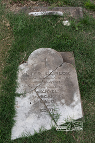
Photograph, Peter Pidgeon, Grave of Peter Lawlor and children, Eltham Cemetery, Victoria, 5 April 2021
The Victorian gold rush came to Eltham in the early 1850s and with it came a crime wave. Local traders called for police protection. This led to the appointment in 1857 of Irish-born Peter Lawlor as Senior Constable at Eltham. In 1859 Peter and his wife Kate were able to move into an official police residence at the corner of Maria Street (now Main Road) and Brougham Street, with stables out the back and a large paddock for grazing across the road. Some of their children went to Eltham Primary School. That 1859 police residence is now the home of the Eltham District Historical Society. The small wooden building on the very corner is a modern replica of the separate police station/office built around 1885-1900. Cases investigated by Constable Lawlor included murders, stealing (horses, cattle, fowls, watches, linen, clothing), a search for a missing person, and two separate instances of abandoned children seeking help. He was officially commended in 1866 for bringing to justice a man who had indecently assaulted an 11-year old girl. Sadly, there was a similar but unconnected case only a few months later. But events had a lighter side; in 1871 Kate lent her piano to the Snowflakes Christy Minstrels for a Catholic Church fund-raising concert. Peter was transferred to Prahran in 1872. He died in 1876 and is buried in Eltham Cemetery with four of his children. His headstone was stolen some time after May 1990 but was returned anonymously (broken into three pieces) in August 2013. It is resting on his grave but has not been re-erected. The Inscription reads: Peter Lawlor Who died February 12th 1876 Aged 55 years Also his children Michael Margaret Maud and EdithBorn Digitaleltham cemetery, gravestones, edith lawlor, margaret lawlor, maud lawlor, michael lawlor, peter lawlor -
 Eltham District Historical Society Inc
Photograph, Peter Pidgeon, Memorial to Peter Glass and Cecile Glass, Eltham Cemetery, Victoria, 5 April 2021
In 1938, Arthur William Glass (known as Peter Glass) was studying painting under Max Meldrum. Much of their inspiration came from the Eltham bush and the nearby Yarra River. With his friends jazz musicians Graeme and Roger Bell, Peter bought land at the top of John Street: enchanted by Montsalvat, he had the objective of building a mud-brick house. War intervened, but then in 1948 he began working for Alistair Knox as a carpenter and mud-brick builder. By then, Peter had married, necessitating a larger house, which he built with help from Alistair Knox. As a trained architectural draftsman, Peter later progressed to working for Alistair in that role, eventually running the drafting office during the 1960s. He was deeply involved in the foundation of the Australian Institute of Landscape Architects, and went on to design many gardens, some in partnership with Alistair Knox and Gordon Ford. He died in 1997 and is buried in Eltham Cemetery with his wife Cecile. Peter Glass (Arthur William) Artist A.I.L.A. 28.8.1917 - 28.12.1997 and his loving wife Cecile Madeleine 23.2.1927 - 6.2.2006 Rest In PeaceBorn Digitaleltham cemetery, gravestones, heritage excursion, cecile madeleine glass, peter glass -
 Eltham District Historical Society Inc
Photograph, Liz Pidgeon, Public Records Office Victoria (PROV) visit to Eltham Justice Precinct, 20 Apr 2018
The original Shire of Eltham was founded in 1871. Prior to its founding, the district was managed by the Eltham District Road Board, which was established in 1856. The initial rate assessment commenced in 1857 for the year ending October 14, 1858. The honour of being recorded with the first assessment went to a farm of 110 cultivated acres at Lower Plenty, owned by John Porter and occupied by Albert Baines. It was assessed at 6d/acre providing for a rate income of £2 15s. In July 2017, officers at Nillumbik Shire Council discovered some early Eltham Road District Assessment books and donated them to the Eltham District Historical Society. The seven volumes were the district’s first six years of rate assessments. This was a unique and significant record of early settlers in the pre-Shire of Eltham. They immediately became one of the oldest and most valuable items in our collection. An article on page 5 in the Eltham and Whittlesea Shires Advertiser, Friday, 21 November, 1941 titled: ‘District’s Early History‘ states: “The first rate book which is still in existence at the Shire Office is for the year ending October 14, 1858 and is probably the best record possible to indicate the development of the district. At the time properties were rated as follows: Cultivated land. 6d. per acre; pasture land, 1d. per acre: estimated annual value of buildings, etc., 6d in the (pound). The total amount of rate recorded for the year was £153/14/8. Properties were described as being situated at Lower Plenty, Yarra Yarra, Eltham, Lower Eltham, Kangaroo Ground, Yarra Flats, Diamond Creek and the Yarra.” Given the precious nature of this collection, priority was given to digitise the rate books and place them in suitable archival storage to minimise further handling. Subsequent discussion amongst our Collections team arrived at the conclusion that the most appropriate home for this valuable record was the Public Record Office Victoria (PROV), the archive of the State Government of Victoria and who are charged with archiving and caring for all Government related records. An approach was made to PROV who confirmed these records would complete their collection of rate assessment books for Eltham. At a small ceremony held Friday, April 20 at the Local History Centre, Eltham, members of the Society and our Collections team, along with Ms. Vicki Ward, MP for Eltham, presented the seven volumes for 1858-1863 along with the complete set of digital files to Mr. David Taylor, Community Archives Manager and Mr. Charlie Farrugia, Senior Collection Advisor, Public Record Office Victoria.Born Digitalassessment ledger, donation, eltham courthouse, eltham road district, local history centre, public records office victoria (prov), rate books, eltham district road board