Showing 1763 items
matching settlements
-
 Bendigo Historical Society Inc.
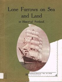
Book - ALEC H CHISHOLM COLLECTION: BOOK ''LONE FURROWS ON SEA AND LAND OR HISTORICAL PORTLAND''
Book. ALEC H CHISHOLM COLLECTION. A souvenir supplement 'Portland Observer' Nov. 19, 1934. Printed by E. Davis, Portland. A history of Portland, Victoria including photographs, a series of articles by Richmond Henty (son of Edward Henty) and articles on the Henty Settlement. Catalogue sticker ''2245 POR'' on spine. Handwritten in ink on flyleaf ''A. H. Chisholm, F.R.Z.S. with warmest wishes from Portland Rotary Club 17.10.44''.Portland Rotary Clubbooks, collections, history, alec h chisholm collection, portland, edward henty -
 Bendigo Historical Society Inc.
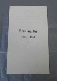
Flyer - Lydia Chancellor collection: Drummartin 1864-1964
The Drummartin Methodist Church was opened in 1864. A new church (in the photograph) was built in 1914 and opened for services in November of that year.four pages flyer. on the front Drummartin 1864-1964. Inside Drummartin Methodist Church, Golden Jubilee Service 11am 1st November 1964. Celebrating 50 years of worship in this church building. Opened on November 1st, 1914, guest preacher: Rev. Alan Matthews. On the back Drummartin Centenary, Pleasant Sunday afternoon 3pm 1st November 1964. Celebrating 100 years of settlement in this district.On the back after the name of Rev. Alan Matthews in blue pen "grandson of N. McKaydrummartin, centenary, methodist church -
 Bendigo Historical Society Inc.
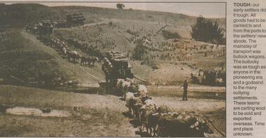
Newspaper - JENNY FOLEY COLLECTION: TOUGH
BHS CollectionBendigo Advertiser ''The way we were'' from Monday, June 3, 2002. Tough: our early settlers did it tough. All goods had to be carried to and from the ports to the settlers' new abode. The mainstay of transport was bullock wagons. The bullocky was as tough as anyone in the pioneering era and a godsend to the many outlying settlements. These teams are carting wool to be sold and exported overseas. Time and place unknown. The clip is In a folder.newspaper, bendigo advertiser, the way we were -
 Federation University Historical Collection
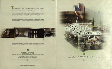
Booklet, From Academy to University, 2001, 2001
Four page signed copy of a booklet concerning the University of Ballarat Art Campus at Camp Street. On back page - "Amidst the fevered atmosphere of multi-cultural settlement and the rush for gold, Ballarat's passion for the arts was born. The founding schools of art have evolved over 130 years to forge a proud identity in the University of Ballarat's 'New School of Arts'. The arts have returned to Camp Street Hill."arts academy, camp street, autographs, david karmouche, kerry cox, pamela davies, rosie mcgregor, tim broome, bill pryor, pater r. wilson, gerry anderson, robert hook, david james, terry lloyd, camp street hill -
 Orbost & District Historical Society
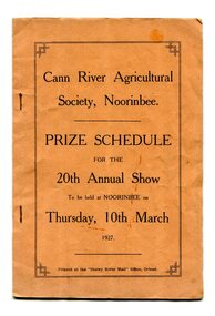
program, Snowy River Mail, 1927
Cann River is a town in the East Gippsland region of Victoria in Australia. The town is located on the Cann River at the junction of the Princess Highway and the Monaro Highway, in the Shire of East Gippsland. Before 1929 the original Cann River settlement was where Noorinbee now stands.Agricultural shows are an important part of cultural life in small country towns and these shows form an integral part of local history. This item reflects the significance of a volunteer group which no longer exists.A stapled paper program, orange with black print,"Cann River Agricultural Society, Noorinbee Prize Schedule for the 20th Annual Show to be held at Noorinbee on Thursday 10th March 1927" inside a rectangular black frame. -
 Warrnambool and District Historical Society Inc.
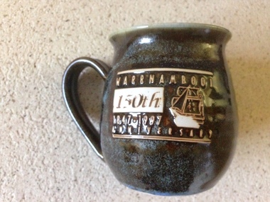
Souvenir, 150th anniversary mug, 1997
This mug is one of a number of items which were made to celebrate the 150th anniversary of the settlement of Warrnambool. It was made by Ian Sadler at the Potter’s Wheel which operated from 74 Liebig Street Warrnambool from around the 1970’s to around 2010. This item is significant in that it is an item which marks the celebration of the 150th anniversary of the settlement of Warrnambool. It also is a locally made item by The potter’s wheel which was one of few artisan businesses which operated successfully in the latter part of the 20th century.Pottery mug, glazed blue black on the outside grey on the inside .Four indentations in surface of the mug. 150th Anniversary details on front with picture of sailing shipWarrnambool 150th 1847-1997 Anniversary on side of mug. Sadler 97 469/500 Warrnambool written on base.potter's wheel warrnambool, ian sadler potter, warrnambool p[ottery 1997, 150th anniversay warrnambool -
 Phillip Island and District Historical Society Inc.
weapon, Cannon Balls, Prior to 1826
One of three Cannon Balls found c1920 on the north side of Rhyll by Oswald Underdown. It is presumed to be from the 1826 British battery Fort Dumaresq. This together with the settlement near Corinella was set up to deter the French from taking possession of the area.Cannon ball, black cast iron, minor rusting - one of three. fort dumaresq, cannon, samuel wright, 3 pound cannon ball, oswald underdown -
 Ballarat Tramway Museum
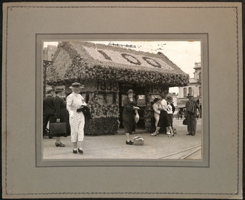
Photograph - Grenville St shelter, 1938
Photo shows the Grenville St shelter decorated for the Centenary of European settlement in the Ballarat district. The tram shelter has the numbers "100". "1838" and "1938" with a number of well dressed ladies outside the shelter. See items 2917 and 6418 for associated images.Yields information about the Grenville St shelter decorated for the Centenary of European Settlement.Block mounted photograph onto grey card with printed edges,ballarat, shelters, ballarat centenary celebrations, celebrations, grenville st, sturt st -
 Mt Dandenong & District Historical Society Inc.
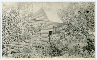
Photograph, Home and Shop of Edward Joseph Price
John Lundy-Clarke grew up in the Kalorama/Mt Dandenong area and later in life (1972-74) began to write a comprehensive history of the district working from an original settlement map in an effort to cover all areas. Edward Joseph Price was the first settler to take up a lot (Lot 1, Section 1) in the Village Settlement. He built a slab hut and brought up his family in 1896. This photograph shows a newer home built in 1908. It had a section used as a shop and also had a large room built that was to be used for public gatherings. Health department regulations led to this being impossible. The house faced Ridge Road.Black and white close up photograph showing a building made from wooden boards with trees in the front. Reverse of photograph has handwritten description by John Lundy-Clarke.On Front STORE MT DANDENONG On Reverse Home and Shop of Edward Joseph Price LOT 1 SECT 1 erected in 1908 on site of earlier dwelling from which goods had been sold without a special room for shop. In picture the room on the extreme left was bedroom for boys Charlie and Ted (Edward John). Under the gable was a large room planned for public use but never used owing to Health Department Regulations. The narrow door (open) and window were the shop which was the district’s first newsagency. Window behind leaves at right was the kitchen. 1908-1912. Gabled portion is now part of home “Mirra Laken” 1975edward joseph price, store, shop -
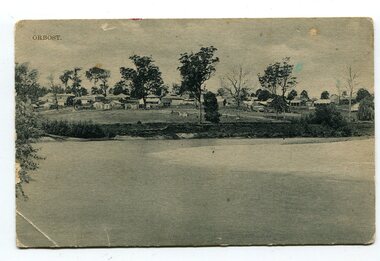 Orbost & District Historical Society
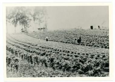
black and white photograph, Campbell. D.S, late 19th century ?
This is a photograph of the settlement of Orbost on the banks of the Snowy River,. In the foreground in the paddock there is a water trough (Bills?) and the B Drain can be seen on the far left. D.S. Campbell had a stationery store in Nicholson Street Orbost and published several black and white postcards of Orbost.This is a pictorial record o The township of Orbost in the late 19th century.A black / white photograph / postcard. There is a river in the foreground with houses and shops in the background behind a cleared paddock.on front - Orbostorbost-19th-century snowy-river -
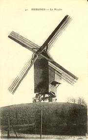 Federation University Historical Collection
Postcard - Postcard - black and white, Le Moulin, Messines, c1914
Mesen (Messines in French, historically used in English) is a city located in the Belgian province of West Flanders. The municipality comprises of one main settlement, the town of Mesen proper. (Wikipedia) Two large battles were fought at Messines during World War One. Black and white postcard of a windmill at Messines, Belgium. chatham-holmes family collection, windmill, messines, moulin, world war, world war 1, world war one, belgium -
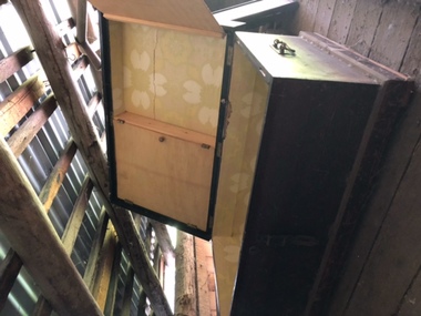 City of Moorabbin Historical Society (Operating the Box Cottage Museum)
Functional object - Travel Trunk ,wood, brass handles, hinges and lock c1860
A handmade wood travel trunk, with internal cupboard fastened by wing clips, side brass handles, brass hinges and a central brass lock with latch for padlock Early settlers used these handmade trunks to bring their worldly goods to the new Settlements in Australia c1850A typical travel trunk used by pioneer settlers as they traveled on sailing ships from Europe to Australia c 1852A Handmade wood Travel Trunk , with internal cupboard, brass handles, lock and hinges c 1860NILpioneers, moorabbin shire, dendy's special survey 1842 brighto, dendy henry, were j.b., moorabbin roads board, market gardeners, early settlers, bent thomas, sailing ships, emigration to melbourne 1850, methodist church, henry box, holloway josiah, box willian, poultry farmers, flower farms, orchards -
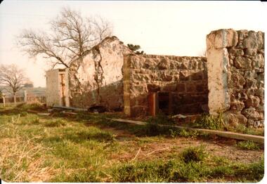
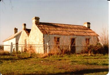 Hume City Civic Collection
Photograph
This is a photograph of one of the many stone ruins of buildings which can be seen in the Sunbury district and surrounding areas. This series of 13 photographs show various views of one of the remaining uninhabited stone cottages which were built in the early days of the district's settlement.A coloured photograph of a stone cottage with a wooden shingle roof and its weatherboard and corrugated iron out building. A valley between two sections of the building suggests it has been built in stages. Three chimneys are visible and the cottage has three 12 paned sash windows with a doorway in the centre of the front. There is a cyclone wire fence and gate across the front and the garden is overgrown.stone structures, shingle roofs, george evans collection -
 Hume City Civic Collection
Photograph
This is a photograph of one of the many stone ruins of buildings which can be seen in the Sunbury district and surrounding areas. This series of 13 photographs show various views of one of the remaining uninhabited stone cottages which were built in the early days of the district's settlement.A coloured photograph of a stone cottage with a wooden shingle roof and the remains of the outbuilding. There is a stone wall across the front of the building. The side view of the building is prominent and there is one 12 paned sash window in the wall and two chimneys either side of the roof valley. A bare deciduous tree is behind the building.stone structures, shingle roofs, george evans collection -
 Hume City Civic Collection
Photograph
This is a photograph of one of the many stone ruins of buildings which can be seen in the Sunbury district and surrounding areas. This series of 13 photographs show various views of one of the remaining uninhabited stone cottages which were built in the early days of the district's settlement.A coloured photograph of the ruins of a stone cottage. The walls are still standing and the end wall bears evidence of the original pitched roof. There is a cleared area in front of the ruins.stone structures, shingle roofs, george evans collection -
 Hymettus Cottage & Garden Ballarat
Work on paper - Book, Belgium in a Picturesque Tour
A descriptive book of Belgium with steel engravings.non-fictionA descriptive book of Belgium with steel engravings.john pascoe fawkner, melbourne, belgium -
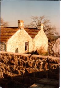
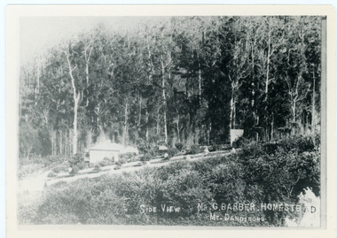 Mt Dandenong & District Historical Society Inc.
Photograph, Side View Mr G. Barber Homestead Mt Dandenong, c1905
Built in 1898 by early settler George Barber the property is still in existence today. It was the home of George, wife Sarah Ann and daughter Ethel.Black and white photograph showing te side view of George Barber's home, later named Forest Edge. c1905. Reverse of photograph has handwritten description by John Lundy-Clarke.Barber's home on Olinda Creek. Lot 25 Sect 1 Village Settlement. Home of George Barber and wife Sarah Ann (nee Richardson). Daughter Ethel.Was bought by Munnerley later Sangster and Kinnear. Later known as Forest Edge. Buggy and wagon shed on right. Photo copied 1973 by JLC. -
 Mt Dandenong & District Historical Society Inc.
Photograph
William Dower came with his family to the Mt Dandenong in 1898, taking up a 10 acre allotment. William and hs wife Elizabeth had seven boys (Will, Harry, Bert, Walter, Joe, Edgar, Robert) and four girls (Emmy, May, Ada, Ruby). The property secured by William Dower was known as ‘Cambridge Gardens’ and had a two room slab hut. William and his sons added another five rooms using trees from the property. The family established extensive crops and worked hard for their success. The acreage extended to 30 when the family bought up neighbouring properties.Black and white photograph showing rows of berry crops. Reverse of photograph has handwritten description by John Lundy-Clarke.LOT 10 section 2 of the Village Settlement owned as registered by Dobson, then Bert Dower, then Edgar Dower. Property was named "Bonnie View" and photo was taken from near where the Channel O tower stands looking south east towards corner of Ridge Road and Selwyn Lane taken 1920.bert dower, edgar dower, bonnie view, channel o, dobson, selwyn lane -
 Ballan Shire Historical Society
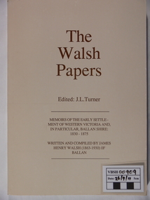
Book - Book. The Walsh Papers, The Walsh Papers, 1985
The former Shire of Ballan commissioned this work which ties in with the formation and early years of the Ballan Shire Historical Society. It is a collection of articles, works and memoirs written and compiled by James Henry Walsh, an early resident of Ballan, that have been edited for publication by James Turner. The book contains maps and photographs and is fully indexed. It is considered by some to be the foremost reference work on the history of Ballan.The book is significant as it is a comprehensive collection covering the history of Ballan. It is a limited edition and now out of print.A soft covered book, ivory in colour. Printed on the cover is - "The Walsh Papers. Edited: J.L.Turner. Memoirs of the early settlement of Western Victoria and, in particular, Ballan Shire: 1830 -1875. Written and compiled by James Henry Walsh (1863 -1930) of Ballan." The back cover is a full page sepia photograph of James Walsh (head and shoulders only) and the printed number "ISBN 0 95599911 1 5". Book No.106. 312 pages.The book bears the stamp of the Ballan Shire Historical Society and the handwritten marking "Receipt P.1." Book No.106 and Reg No. (VC) 00909 in pencil.walsh james henry, ballan memoirs, turner j l, ballan history -
 Bendigo Historical Society Inc.
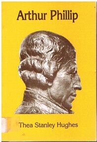
Book - ALEC H CHISHOLM COLLECTION: BOOK ''ARTHUR PHILLIP'' BY THEA STANLEY HUGHES
Book. ALEC H CHISHOLM COLLECTION. 112 page paper back illustrated biography of Arthur Phillip, first Governor of the Colony of NSW and the early settlement from 1787 to 1792. Front cover has a picture of a bust of Arthur Phillip. Published in 1982 by Movement Publications, Cabarita, NSW and printed by Star Printery, Erskineville, NSW. Catalogue sticker ''2148 HUG'' on spine. ISBN 0 908076 15 0.Thea Stanley Hughesbooks, collections, biography, alec h chisholm collection, thea stanley hughes, arthur phillip, history, biography, australiana -
 Ballarat Tramway Museum
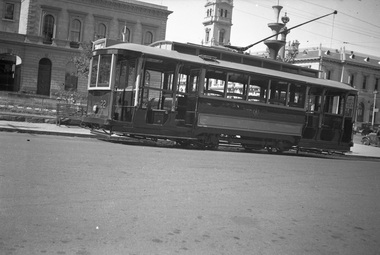
Negative, Wal Jack, 1938
Yields information about Ballarat 's No. 22 during 1938Set of two Negative and Digital images of the Wal Jack Ballarat Negative file of No. 22 in Sturt St at the corner of Lydiard St with the Post Office in the background, photograph during the Centennial celebrations of 1938, given the decorations in the background. Tram has the destination of Gardens via Sturt St West. Note the decorations in the for the centenary of settlement in the Ballarat district in 1938 - see Reg Item 5906 Two copies of the negatives on file.trams, tramways, sturt st, centenary, tram 22 -
 Bendigo Historical Society Inc.
Article - JEWISH SYNAGOGUE JEWISH SETTLEMENT ON THE GOLDFIELDS OF VICTORIA, 1970
JEWISH SYNAGOGUE JEWISH SETTLEMENT ON THE GOLDFIELDS OF VICTORIA Two page article from the Jewish Geneological Society (Vic) Inc. Describes after 1851 was the turning point for settlers in the Port Phillip district. Sub headings: The Jewish life in Ballarat The first synagogue - 1855 A new synagogue for Ballarat - 1859 Eureka Stockade of 1854 Hebrew day School opened in 1870 Jewish population declines Bendigo (formerly known as Sandhurst)buildings, jewish synagogue, jewish synagogue, new synagogue -
![Painting: Park Street [Adeney Avenue] Kew](/media/collectors/550653872162f11fb04854aa/items/5826877cd0cdd11284ad5413/item-media/614ac683a53a0756fd5e49da/item-fit-380x285.jpg) Kew Historical Society Inc
Kew Historical Society IncPainting, Park Street [Adeney Avenue] Kew, c. 1896
‘Adeney Avenue’ was the title given to this painting following its donation to the Kew Historical Society, yet the work’s origins predate the naming of Adeney Avenue in 1907 [originally gazetted as ‘Park Street’ (1865) and ‘Park Street South’ (1875).] Park Street ran between High Street and Parkhill Road beside what was later to become ‘Victoria Park’. This area was described in 1851 as “…a dense forest of gums and wattles which were to be largely cleared by 1888 after the naming of a recreation reserve”. The Reserve was still bisected by an unnamed creek in 1896, when the area was surveyed by the MMBW. The panoramic vista selected by the artist would appear to include ‘Eborensis’ (c.1895) on the corner of Parkhill Road and what was then Park Street, with views across cleared land towards the distant ranges. In the 19th century, north Kew was largely undeveloped farms stretching down to the Yarra. Oil on canvas by an unidentified artist of a panoramic view depicting what is now known as East Kew with mountains on the horizon. In the foreground is a two storey brick residence - Eborensis - located on the northeast corner of Parkhill Road and what is now Adeney Avenue. The view of the landscape and its rolling hills resulted from farming practices adopted following colonisation and settlement. Trees in the foreground and in the distance include remnant Eucalypts and introduced exotics.Label on rear of frame states "House on corner of Adeney Ave & Parkhill. [Regd. 254"]. Otherwise unsigned and undatedadeney avenue (kew), eborensis, park street (kew) -
 Warrnambool and District Historical Society Inc.
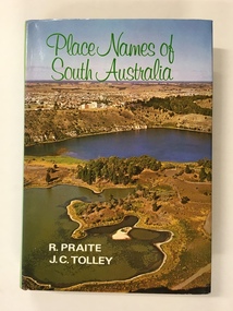
Book, Place Names of South Australia, 1970
This book gives information on the place names of South Australia and the origins of the names. It was compiled by Ronald Praite and John Tolley in 1970 and so is somewhat out of date as more place names would have to be added today. European settlement began in South Australia in 1836.This book is of minor interest to those in the Warrnambool area and may be useful for those researchers whose families have some connection to early South Australian history. This is a hard cover book of 208 pages. The cover is dark red with the names of the book and the authors on the spine. The dust cover has a colour photograph of a South Australian panorama on the front and a plain green back cover. The book has a Foreword, Sources of Reference, Acknowledgements, Introduction and an alphabetical listing of South Australian place names and the origins of the names. There are many black and white photographs supplied by the South Australian Tourist Bureau. There is some colour fading on the dust cover.Front Cover: ‘Place Names of South Australia’ ‘R.Praite’ ‘J.C.Tolley’ history of south australia, place names of south australia, ronald praite, john tolley -
 Heytesbury District Historical Society Inc.
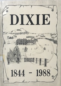
Book, Dixie 1844-1988
Paperback with black and white photographs, large map of County of Heytesbury inside back cover. An account of the settlement of the area known as Dixie in the County of Heytesbury, including pioneers, soldier settlers, the school, churches, sports club etc. during the period from 1844 to 1988. heytesbury shire - history, early settlement - south west victoria, dixie -
Warrnambool and District Historical Society Inc.
Medallion, Stokes Melbourne, Centenary of Victoria 1935, 1933
This medal was given to Victorian school children to celebrate the centenary of European settlement in Victoria and the establishment of Melbourne in 1835. Portland was settled by the Henty brothers and John Batman and John Fawkner are the two names associated with the founding of Melbourne. The Melbourne Shrine of Remembrance was dedicated during these celebrations. This medal is a memento of the centenary of Victoria and may have been given a local Warrnambool school child. Circular silver coloured medal with ring at top and a further ring inserted. The obverse features a sailing ship entering a bay. Since "Portland " is part of the text it is assumed the bay is situated in Portland. Text The reverse features a hatted man wearing a suit and holding a walking stick standing on a grassy shore, a body of water and a sky line of buildings Obverse CENTENARY OF VICTORIA 1934 PORTLAND 1834 Reverse CENTENARY OF MELBOURNE 1935 1835 -
Greensborough Historical Society
Book, Melbourne Water, Plenty River Waterway Management Activity Plan 2000, 2000_
This report covers the catchment of the Plenty River from its upper reaches in the Great Dividing Range to the confluence with the Yarra River at Viewbank. It discusses ecological diversity and methods of improving water quality and significant areas of the catchment. Includes a brief history of settlement along the Plenty River.This is a significant plan for the improvement of the Plenty River.207 p., maps, folding maps. Printed on white paper with black spiral binding and clear plastic front cover.plenty river, melbourne water -
 Sunbury Family History and Heritage Society Inc.
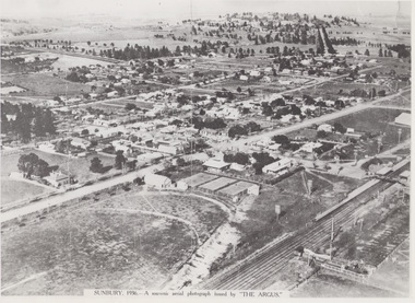
Photograph, 1936
The aerial view of Sunbury was featured in The Argus newspaper in 1936 in recognition of 100 years of European settlement of the area. It shows the extent of the township in 1936 which extended from the railway line in the west to the Jackson Creek in the east and the Sunbury Asylum in the south and northwards towards Macedon Street. The photograph was taken when Sunbury was a country settlement 25 miles ( 37 kms) from Melbourne. Since the 1980s the area grown rapidly and is now an outer suburb of Melbourne.A black and white aerial photograph with a cream border of the Sunbury township. SUNBURY 1936 - A SOUVENIR AERIAL PHOTOGRAPH ISSUED BY THE ARGUS.aerial photographs -
 Port Fairy Historical Society Museum and Archives
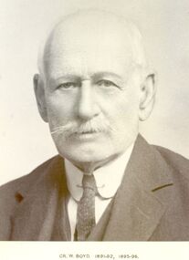
Photograph, Cr William Boyd Shire of Belfast President 1891-92 95-96
Councillor William Boyd was the son of Alexander Boyd who emigrated from Scotland and purchased the property known as Tarrone station in 1884. William managed the station grazing cattle and sheep. The area was later to become part of the Soldier Settlement land after the Second World War.Black and white portraitbelfast, president, government, portrait, shire, council, municipal, local-government, tarrone -
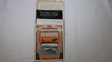 Kiewa Valley Historical Society
Journals - Department of Agriculture, 1. 1950s and 2. one 1932 & others 1970s
The Kiewa Valley has been a farming district from early settlement of white people. This has continued until the present although the nature of farming has varied over the years. Access to information has improved with transport and technology. The journals kept the farmers informed and up to date.These booklets and journals were one of the few sources of information during the 1950s for the isolated farmers of the Kiewa Valley. The Kiewa Hydro Electric Scheme improved both transport and technology during the scheme's construction from the 1940s. It provided the township of Mt Beauty at the upper end of the valley where shops and schools were constructed, roads were improved out of the valley and the supply of electricity for milking etc. became available. 1. 14 articles each bounded by 2 staples, and each reprinted from Dept. of Agriculture Journal on a particular topic relating to Agriculture. All black & white and c1950s. 2. 4 Journals with colored covers 3 from Victoria Dept. of Agriculture (1932, 1974 & 1975) and 1 from Sth. Australia.1. "J.H.Wallace" hand written top right corner of covers of pamphlets titled 'Diseases Affecting /Young Cattle' and 'Mastitis'. "AHW" hand written top right corner of cover of pamphlet titled ' Grading Land for Irrigation' 2. Nonefarming, agriculture, cattle, pasture, kiewa valley, department of agriculture in victoria, kiewa hydro electric scheme,