Showing 1506 items matching "acres"
-
 Sunbury Family History and Heritage Society Inc.
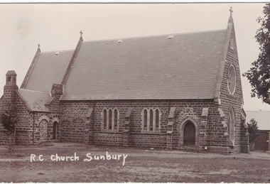
Postcard, R.C. Church Sunbury
On 17th January 1856, two acres of land was granted for the building of a school and church on that site in Macedon Street. A small temporary building was erected on the site and on 13th December 1864 the foundation stone was laid for the new stone church which was known as 'Our Lady of Mount Carmel'. At times it was also known as St. Mary's Church, which was confusing because the Anglican Church is named St. Mary's Church.It is one of the oldest churches to be established in Sunbury.A non-Digital post card photograph of the Roman Catholic Church in Sunburyour lady of mount carmel catholic church, macedon street, sunbury -
 Bendigo Historical Society Inc.
Document - SEDGWICK INFORMATION
Document, Sedgwick, was known as Upper Emu Creek until 1901. It is located ten miles south of Bendigo in hilly sedimentary and granite country.The first freehold grants were taken up in 1854. In 1861 the Strathfieldsaye Road District was Proclaimed. Five years later it became the Shire of Strayhfieldsaye.Mining west of the Axe Creek commenced in 1863. Agriculture, farmers made modest livings from vineyards, orchards,dairy cattle, eggs and tomatoes. The Osborne family had seventy acres planted to apples. Prior to 1934 Favaloros collected cream from district farms, then fresh milk in cans was carted to Bendigo until 1970.document, sedgwick -
 Whitehorse Historical Society Inc.
Letter - Correspondence, House 113 Springvale Road, Nunawading, n.d
A letter from Nance Leach (undated) telling the history of John McClelland's house. He arrived from Ireland in 1863...5 years later they selected 80 acres at Tunstall (Nunawading) and cultivated a market garden, The property was on the site of Stanley Engineering. The couple and one daughter retained the house and Whitehorse Road section of the property about 1948. This was sold to 'Turners' on condition Turners removed the house to 113 Springvale Road for Miss Tess McClelland. When she died the house was sold to Hal Johnson and he later sold it to Mr Florio. John McClelland died 1911 aged 77. The house was called 'The Elms'.springvale road, nunawading, no 113 (the elms), nunawading, mcclelland, john, stanley works pty ltd, turner industries, mcclelland, tess, johnson, hal, florio (mr) -
Kew Historical Society Inc
Archive (Sub-series) - Subject File, Latrobe Golf Club
Kew Historical SocietySince its foundation in 1958, members of the Kew Historical Society have been compiling and storing information about subjects relating to the history of Kew and its environs, of which this file is an example. Arranged by Secondary Values (value of records to users)Subject file containing information about the Latrobe Golf Club and course. The file contains a copy of a 1959 newspaper account of the building of the clubhouse on part of the former Lucern Farm which Thomas Wills established 120 years previously. The farm was later owned by Perce Lay, a Gallipoli veteran who progressively sold off parts until only 24 aces of the original 176 acres was left. The file also has a typescript of the back of Lucern Farm sale brochure for the auction on 14/4/1956. suggesting possible uses. Also gives an account of Thomas Wills' life and the improvements he made to the land. thomas wills, lucern farm, perce lay, latrobe golf coursethomas wills, lucern farm, perce lay, latrobe golf course -
 Wodonga & District Historical Society Inc
Album - Hume Reservoir Australia Album - Excavations for foundations inside coffer dam, January 1927
This set of photos is from a leather bound album bearing the inscription "HUME RESERVOIR AUSTRALIA" plus 'The Rt. Hon. L. C. M. S. Amery, P. C., M .P.' all inscribed in gold. It was presented to The Rt. Hon. L. C. M. S. Amery, P. C., M. P, Secretary of State for Dominion Affairs on the occasion of his visit to the Hume Reservoir on 2nd November 1927. This album is of local and national significance as it documents the planning and development of the Hume Reservoir up to 1927. It was the largest water reservoir in the British Empire. The album records the pioneering engineering work that went into its construction.DEPARTMENT OF PUBLIC WORKS, N.S.W. RIVER MURRAY WATERS SCHEME. HUME RESERVOIR. 21. Excavations for foundations inside coffer dam. New South Wales. January 1927. Cofferdams are temporary structures used where construction is being carried out in areas submerged in water. They are most commonly used to facilitate the construction or repair of dams, piers and bridges. To divert the river, a Coffer Dam was built across the old bed above and below the Dam site and tying into the end of the concrete wall built inside the levee bank. This completely surrounded the remainder of the site of the Dam and south wing wall, including an area of 12½ acres. hume reservoir australia, river murray waters scheme, hume reservoir construction, coffer dam -
Bendigo Historical Society Inc.
Document - Mining Leases Victoria 1889, 1876
Eleven page photocopied document. On front page: 1889, Victoria. Mining Leases....ordered by the Legislative Assembly to be printed 11th September 1889. Sandhurst and Eaglehawk Division returns in a table format, show the number of lease, the lessees, (mine name in full) consent to transfer to, area, number of men required to be employed as per Labour Covenant, number of men employed not including Tributors, number of Tributors. For example: United Hustler's and Redan Co. N.L., lease number 4148; 35 acres 2 roods, 25 perches; 12 men working; worked in conjunction with 4147 on which 56 men are employed. mining, sandhurst, mining leases, labour convenant, tributor, mine transfers, lease number -
 Bendigo Historical Society Inc.
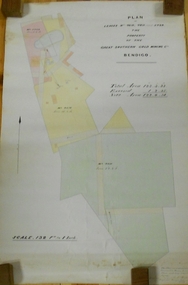
Plan - MARKS COLLECTION: LEASE PLANS GREAT SOUTHERN GOLD MINE BENDIGO
Plan on heavy paper, tightly rolled. On top of plan "Plan of Leases 5429, 4810, 4811 and 5429", The Property of the Great Southern Gold Mining Co. Bendigo' \Total area123 acres, 3 roods, 33 perches, excised, nett area 122, 0. 38. On bottom '32 feet to one inch' and 'This plan was devised from Government Mining Lease Plans and from actual survey' Signed E.F Brown, certificated mining and authorised surveyor 25/6/87' Leases No. 5429 and 4810 details location of shaft, tramway, battery, engine house and boiler. Large mining dam outlined.bendigo, mining, great southern gold mine -
 Bendigo Historical Society Inc.
Document - MCCOLL, RANKIN AND STANISTREET COLLECTION: INDENTURE GOLD MINING LEASE CROWN LAND 11197 ALICE PEEL, 8th July 1945
6 page indenture document plus plan, between King George VI and Alice Peel Executrix of the Will of Edward Peel, deceased., dated 8th July, 1945. Lease number 11197, total area of 11 acres, 3 roods, 15 perches. Leases shown on plan: 1197, 1198, 11062, 10690, 11141, 11075. Cemetery reserve shown. Streets: Gladstone Street, Adam Street, Houston Street, Fletcher Street, Honeybone Street, Key on plan shows depths correlated to colours. On back of document history of ownership of lease shown - Deborah Gold Mines No Liability, dated 1946, and 1950.bendigo, mining, lease 11197 bendigo. edward peel, alice peel, edward pell, gladson, adam, huston fletcher and honeybone streets. -
 Bendigo Historical Society Inc.
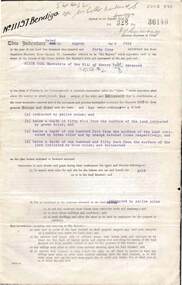
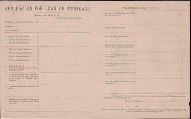
Document - KELLY AND ALLSOP COLLECTION: APPLICATION FOR LOAN ON MORTGAGE
Application for Loan on Mortgage. Messrs Allsop & Co., View Point, Sandhurst. Application has space for name, occupation, amount of Loan, number of years, interest rate, Where, number of Allotment, Section, parish or County, Area, Leasehold or Freehold. Applicants opinion as to value of Land alone. Number of Acres under Cultivation. How Land is watered. State Shire Valuation, Description of Buildings and materials used, Fences, Improvements. Application for Loan on Mortgage. Messrs Allsop & Co., View Point, Sandhurst. Application has space for name, occupation, amount of Loan, number of years, interest rate. Where, number of Allotment, Section, parish or County, Area, Leasehold or Freehold. Applicants opinion as to value of Land alone. Number of Acres under Cultivation. How Land is watered, State Shire Valuation, Description of Buildings and materials used, Fences, Improvements. Is applicant in occupation of Property, if not who is, and at what Rental. Are Buildings Insured, if so, what amount. Is the Property encumbered, is so, to what amount. Present marketable value of the whole, and names and addresses of two references. Authorization to deduct from the advance the costs of the Mortgage and Charges on obtaining the Loan. Note at the end - A Government plan, or sketch showing the position of the land and written valuation from an acknowledged Valuer. On the back is space for a Valuator's Report and a note to the Valuators, also a Proposal for Loan on Mortgage with details of the loan. Date on the form is 188-.business, stockbroker, kelly & allsop, kelly and allsop collection - application for loan on mortgage, allsop & co. -
 Eltham District Historical Society Inc
Work on paper (Sub-Item) - Photograph, Orchards at Hurstbridge, 1924
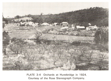
With the extension of the railway to Hurstbridge in 1912, large commercial orchards were able to expand. By 1914, 1,886 acres of orchards were under cultivation, with a considerable proprotion of the fruit being exported overseas. After World War One, the industry declined, mainly due to competition from other areas. This photo shows an orchard in the foreground with the township of Hurstbridge in the distance. The photo was taken in 1924, the same year that Hurstbridge was declared a township. orchard, hurstbridge, rose postcard -
 Greensborough Historical Society
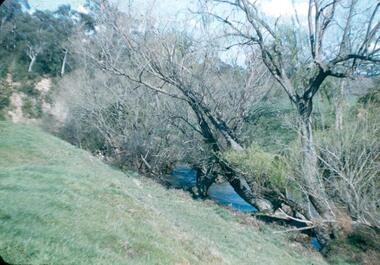
Photograph - Digital image, Frank Robinson, Willows in the Plenty River, looking south west to cliffs, 1954_
Willows in the Plenty River, looking south west to cliffs. The Blackjack property, house and acres of fruit orchards ran down to the Plenty River off Hume Street Greensborough and was the home of the Robinson family to late 1956. The photographs were taken as slides by Frank Robinson and digitised by his son James in 2015. Oral history has it that Anthony Beale was the first to bring willow cuttings from the island of St Helena, to Australia.Digital copy of colour photograph.robinson family, blackjack, plenty river -
 Greensborough Historical Society
Newspaper Clipping - Digital Image, Cherel Sartori, Funeral notices for Claude Amiet 1998, 20/01/1998
Death notices collected by Cherel Sartori's following the death of Claude Amiet in 1998. Kell's Cottage was built 1917, at 112 Henry Street Greensborough by William Mitchell on the 60 acre dairy farm owned by Ethel and Walter Kell. This collection of photographs was copied by Cherel Sartori (who owned the house from 1990-2000), following a visit by Claude Amiet who lived in the house as a child in the early 20th century.Digital copy of funeral and death noticeskell's cottage, claude amiet, cherel sartori -
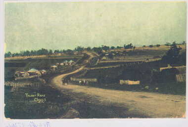 Clunes Museum
Photograph
PHOTOGRAPH TAKEN ON TALBOT ROAD, OPPOSITE THE TURN TO CEMETERY LOOKING EAST.BLUE STONE BUILDING LEFT OF ROAD ACROSS KILKENNY CREEK WITH CAMEL HUMPED ROOF OF THE OLD BRITISH HOTEL RUN BY JOHN CONRAD WEICKHARDT UP TIL 1905 OR SO. IT WAS ON 40 ACRES WERE FAMILY RAN A FEW COWS, PIGS POULTRY, KILLED AND MADE THEIR OWN SAUSAGES, BLACK PUDDINGS ETC. ALSO MADE BUTTER & CREAM.LAMINATED COLOUR PHOTOGRAPH TAKEN ON TALBOT ROAD LOOKING EAST AND DESCRIPTIVE LETTER RE PHOTOGRAPH AND FAMILY INTERESTS.local history, photography, photographs, hotels, british -
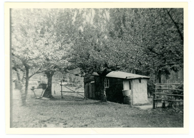 Mt Dandenong & District Historical Society Inc.
Photograph
French Louis Merci is shown as J.L. Merci on the settlement map, having selected Lot 26 in the Village Settlement in 1901.It was a 5 acre Lot bordering Barbers Road and the Dray Track (now Link Road). Louis shared his hut for some time with Peter the Swede. When Louis became ill with cancer and could no longer work he sold his property to George Barber in return for a weekly payment.Black and white photograph of hut in row of blossoming trees.french louis, louis merci, j l merci, peter the swede, george barber, link road, barbers road, hut, dray track -
 Bendigo Historical Society Inc.
Administrative record - The Land Act 1869
The Victorian Parliament passed Land Acts in 1860, 1862 and 1869, which offered settlers land within defined agricultural areas. Settlers paid for half of an allotment on selection at a uniform price of £1 per acre and paid rent on the other half for usually 7 years. By the end of the period, to obtain title to the land, settlers would have had to pay the balance of the purchase price and make certain improvements. (from Wikipedia)Blue book missing front cover, some loose pages. The book contains amendments to the land act 1869. throughout the book there are handwritten notes with names and localitiesRed pen mark at the front Land(?) 869. some of the nameswriten are: Sanderson, O'Brien, H. Jackson, R. Wharton, W. Porter, J. Stewart, Foley and Mortonland act, victorian legislation -
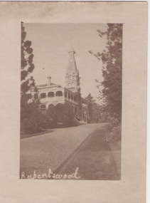 Sunbury Family History and Heritage Society Inc.
Photograph
Rupertswood Mansion was the Sunbury residence of the Clarke family from 1874 until 1922 when H.V.McKay of Sunshine Harvester fame bought it from Hon. W.L. Russell Clarke in 1922. After the death of H.V.McKay in 1926, it was purchased by W. Naughton who then sold the mansion and 700 acres of land to the Salesian Fathers, who are the present owners. It is now the site of Salesian College, a Catholic co-educational college fore secondary students.Rupertswood Mansion has had close social, spiritual and educational links with Sunbury's development since 1874.A small sepia photograph with a cream frame of a driveway leading to a large mansion. 'RUPERTSWOOD' written in the LH corner of the photograph.rupertswood mansion, clarke, w.j.t., mckay, h.v., salesian college -
 Melton City Libraries
Photograph, Wendy, Bon and Peter Barrie, c.1948
Sections of the property from the Ferris Rd to the Toolern Creek were compulsorily acquired for the construction of the Melton By Pass road to become the Western Freeway. The freeway plan divided the original 1911“Darlingsford” farm. The section of the Ferris Rd 70-acre paddock belonging to Bon became the Freeway and roundabout. The construction to the west passed over the paddocks and the internal track along the fences connecting the Barrie brothers to the original Homestead at the Toolern Creek. Wendy, Bon and Peter Barrie entering Ferris Road from houselocal identities -
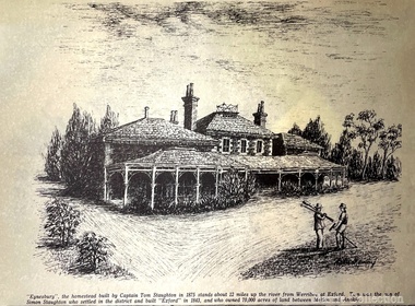 Melton City Libraries
Drawing, Eynesbury, Unknown
"Eynesbury, Eynesbury Road was one of four properties into which Simon Staughton’s Exford station, established in 1841, was subdivided for his sons after his death in 1863. The Eynesbury station of approximately 20,000 acres was inherited by his second son, Samuel Thomas Staughton. Eynesbury remained unsubdivided until redevelopment for residential purposes commenced in the early 2000s, at which time it was the largest pastoral property within 300 kilometres of Melbourne". Detailed sketch of the Eynesbury propertylocal architecture, local identities -
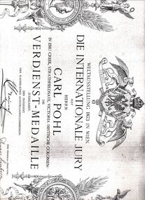 Bendigo Historical Society Inc.
Document - STRAUCH COLLECTION: CARL POHL CERTIFICATE OF MERIT
Johann Carl Pohl (1824-1/6/1906) came to Bendigo in the 1850's. He was originally a butcher in White Hills but then planted about 12 acres of vines at Emu Creek. He was a very successful winemaker, winning prizes throughout Australia and overseas for his red wines. This certificate is from the 1873 Vienna World's Fair, again for his wine. He also won prizes at the Vienna Fair in 1875.Copy of a certificate of merit issued to Carl Pohl Emu Creek Strathfieldsaye Victoria by The Internationale Jury Weltausstellung 1873 in Wien.document, certificate, pohl -
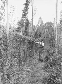 Ringwood and District Historical Society
Photograph, Carlton and United Brewery Hop Farm. c. 1955
Black and white photograph (2 copies)Image shows man standing in hop field. Typed under one photograph- "Carlton and United Brewery Hop Farm, c.1955. Written on back of one mounting sheet- "C & U Brewery Hop Farm, Maroondah Hwy.Est. 1950 on 2 acres. A. Nash in charge. "Ringwood Special" & "Pride of Ringwood" developed here". Written on back of other mounting sheet, "Experimental Hop Farm, Maroondah Highway. -
 Ringwood and District Historical Society
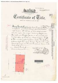
Document, Certificate of Title - Mary Burchett, Lilydale Road, Ringwood - part of Crown Section 20, Parish of Warrandyte, County of Evelyn - 14th January, 1910
A4 copies of Landata Victoria Historical Search documents - Vol 3398 Fol 679415.Mary Burchett of Lilydale Road, Ringwood, Married Woman, is now the proprietor of an Estate in Fee-simple subject to the Encumbrances notified hereunder ... 55 acres 3 roods 35 perches or thereabouts, being lots 8 and 9 on plan of subdivision no.4315. Subdivision map includes un-named road - Grandview Grove (later Bemboka Road, Warranwood, Vic). Title transferred to Theodore Hartley Burchett, 27th July, 1911. -
 St Kilda Historical Society
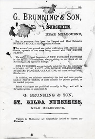
Document - Advertisement, G Brunning & Son St Kilda Nurseries, Pre - 1901 (original)
George Brunning was born in Suffolk, England, on 2 October 1830 and settled in St Kilda in June, 1852. He was a gardener and became part-proprietor and manager of Rule's Nursery in Richmond before establishing the first nursery of his own in 1861. Following his death on 5 June 1893, his sons continued the business. An article published in Punch in 1907 observed 'Nearly all the flowers grown in and around Melbourne, indeed, throughout Victoria, which are not native to Australia, had their origins in the nurseries of George Brunning and Sons. The statement is a large one to make, but it is literally true.'Single page black and white photocopy of advertisement from an unidentified publication for G Brunning & SonG Brunning & Son, St Kilda Nurseries, Near Melbourne, Beg to announce they have the Largest and Most Extensive Nursery Stock in the Australian Colonies. Ten acres of our ground are under cultivation with Flowers and Shrubs, upwards of two acres being covered with pot grown plants. We are the biggest Importers of new florists flowers in the Southern Hemisphere, always adding to our Stock all the Novelties as they appear in Europe. Our nurseries are particularly noted for the fine collections of roses, show, fancy and zone pelargoniums, fuchsias, picots, carnations, and other leading Plants, Shrubs, etc. In addition, we cultivate extensively the best and most popular kinds of fruit trees, of sorts suitable for private gardens, or for market purposes. Priced Catalogues are published annually in May, and will be forwarded gratis on application to G Brunning & Son, St Kilda Nurseries, Near Melbourne. Visitors to Melbourne are respectfully invited to inspect our Nurseries.g brunning and son, plant nurseries victoria, st kilda, 19th century -
 Ringwood and District Historical Society
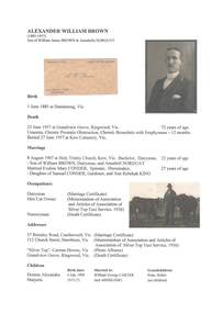
Document - Biography - Family Tree Extract, Alexander William Brown (1885-1957) - Nurseryman, Grandview Grove Ringwood (Warranwood) Vic
A4 folder containing genealogical information, copy of will and copy of probate administration record including real estate assets for A.W. Brown, Grandview Grove Ringwood (Warranwood) Vic.EXTRACT: Inventory of Real Estate Assets (for Probate purposes) 1. Grandview Grove, Ringwood Land containing 10 acres or thereabouts situate in Grandview Grove Ringwood being part of Crown Section 20 Parish of Warrandyte County of Evelyn and being the land described in Certificate of Title Volume 5781 Folio 174 on which is erected a 7 room house, a bungalow, shed and 2 glass houses valued by E. Miles, Ringwood - £5077-0-0 2. Kardinia Crescent, Ringwood Land containing 2 acres 3 roods 24-1/2 perches situate in Kardinia Crescent Ringwood being Lots 33 and 34 on Plan of Subdivision Number 12040 and being part of Crown Section 20 Parish of Warrandyte County of Evelyn and being the land described in Certificate of Title Volume 7141 Folio 080 valued by E. Miles at £350-0-0 -
 Eltham District Historical Society Inc
Work on paper (item) - Photograph, 2 Metery Road, Eltham South
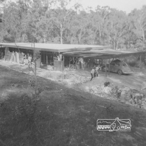
Robert and Ada Zull built an Alistair Knox designed house at 2 (lot 8) Metery Road, Eltham, a one acre property for their family of five in the mid 1960s. This series of photographs shows the newly built house and pagoda, building rubble and wet conditions at the time. Susan Bennett, nee Zull's reminiscences are published in EDHS Newsletter, February and April 2020. ".. Outside was a mess of wet, sticky clay that made access to the house difficult... " This series of photographs together with the account of personal remiscences provide a unique document of the construction of an Alistair Knox designed home. Knox was a pioneer in the use of mudbricks and recycled materials and is significant to his contribution of this style of architecture in Eltham and the wider Shire of Nillumbik.zull family, eltham south, 2 metery road, alistair knox, construction, mud -
 Eltham District Historical Society Inc
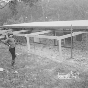
Work on paper (item) - Photograph, 2 Metery Road, Eltham South
Robert and Ada Zull built an Alistair Knox designed house at 2 (lot 8) Metery Road, Eltham, a one acre property for their family of five in the mid 1960s. This series of photographs shows the one story house with its roof in place. Susan Bennett, nee Zull's reminiscences are published in EDHS Newsletter, February and April 2020. "..The block was big.. Building the house was slow going...the house had a concrete floor and a roof, but no windows..."This series of photographs together with the account of personal remiscences provide a unique document of the construction of an Alistair Knox designed home. Knox was a pioneer in the use of mudbricks and recycled materials and is significant to his contribution of this style of architecture in Eltham and the wider Shire of Nillumbik.zull family, eltham south, 2 metery road, alistair knox, bush block, construction, vw beetle -
 Federation University Historical Collection
Book, Richard A. Proctor, Easy Star Lessons, 1881
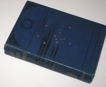
In 1873 Teesdale residents formed an institute to provide literature to improve the minds. The site was gazetted on 25 October 1875 – a one acre site on the corner of Bridge Street and Mercer Terrace. A Mechanics Institute was built and later a supper hall was added in front of the institute. The mechanics institute and supper hall was destroyed by fire on the night of 29 March 1969. (http://linkingtowns.com/index.php?option=com_content&view=article&id=91&Itemid=252) Blue hard covered book of 239 pages. Many illustrations f constellations during each month. Inside front page 'Mechanics Institute Teesdale No 270'astronomy, library, teesdale, mechanics institute -
 Yarrawonga and Mulwala Pioneer Museum
Stripper, The Stripper, 1843
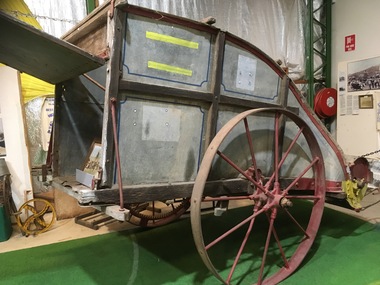
The Stripper was invented by John Ridley in 1843, while trying to overcome harvest labour shortage. In the early ays of Colonial South Australia a labour force was essential to harvest the wheat crop quickly before the grain shook out and fell to the ground. The stripper solved this problem, as t could strip 10 acres [4 hectares], handling approx. 180 bushels [5 tonnes] per day. This replaced 14 men using scythes.Strippers were used in this area between 1870's to the early 1900's.Then the Stripper Harvestors took over this processprinciple of the stripper----The wheat heads were knocked off the straw by a fat revolving beater ,and the grain, mixed with the husks and short straw, was propelled to the rear tin box. When the box became full, the contents were emptied into a winnower for cleaning. Recorded as Mitchell Stripper -
 Whitehorse Historical Society Inc.
Photograph, Tombstone - Slater family
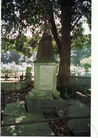
William Henry Slater emigrated from England and began growing medicinal herbs near Koonung Creek, Blackburn North in 1862. He also distilled eucalyptus oil for use at Melbourne Hospital and it was exported overseas under the 'O'Possum' brand. He later replanted his land with orchards but land taxes and rates forced the sale of the property. In 1979 the Nunawading Council purchased 7 acres of the land, now called , Slater ReserveColour photograph of the Slater family tombstone at Box Hill Cemetery. William Henry Slater died 23 May 1894 - 66 years of age Mary Ann Slater died 12 August 1912 - 83 years of ageslater, william henry, mary ann, herb farms, slater reserve -
 Wodonga & District Historical Society Inc
Domestic object - Lady's Pen and ink set, c1920s
This pen and ink set is part of a collection donated by Mrs. Jean Raper. It was used by the teacher at Upper Gundowring Primary school, Victoria. The school, number 2733, opened on 13 July 1886. Due to changing demographics in the region, in 1953 the school was merged with schools from Dederang North, Kergunyah, Gundowring, Kiewa, Red Bluff, Charleroi and Gundowing North on a 10 acre site with 11 rooms at Kiewa to become Kiewa Valley Consolidated School.This item is from Raper Collection donated to the Wodonga Historical Society by Mrs. Jean Raper. A china pen and ink set painted with a floral design.pen and ink, personal items, teacher supplies, upper gundowring primary school -
 Eltham District Historical Society Inc
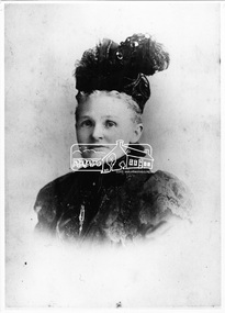
Photograph, Agnes Cameron (nee Bell) (daughter of John Bell Senior). Pigeon Bank, Kangaroo Ground
Agnes Bell (1824-1924) from a pioneer Kangaroo Ground family, married Scotsman Ewen Hugh Cameron (1831-1915). In 1863 he took up the 100 acre farm “Pigeon Bank” at Kangaroo Ground where the family lived. In 1874 Cameron was elected as the Member for Evelyn in the Victorian Legislative Assembly and held the seat until he retired in 1914 as “Father of the House”. Agnes and Ewen had eight sons and three daughters. This photo forms part of a collection of photographs gathered by the Shire of Eltham for their centenary project book, "Pioneers and Painters: 100 years of the Shire of Eltham" by Alan Marshall (1971). The collection of over 500 images is held in partnership between Eltham District Historical Society and Yarra Plenty Regional Library (Eltham Library) and is now formally known as the 'The Shire of Eltham Pioneers Photograph Collection.' It is significant in being the first community sourced collection representing the places and people of the Shire's first one hundred years.Digital imagesepp, shire of eltham pioneers photograph collection, kangaroo ground, agnes cameron (nee bell)