Showing 864 items matching "surveyor"
-
 Bendigo Historical Society Inc.
Document - CONTRACT OF SALE - 11 JUNE 1895 - WILLIAM HENRY CUNDY TO ARTHUR ALLSOP AND MICHAEL KELLY
Contract of sale - 11 June 1895 - William Henry CUNDY to Arthur Allsop and Michael Kelly. Contract of sale and contract of 'Hiring and Letting' between William Henry Cundy of Barkly Place, Bendigo , Surveyor and Arthur Allsop and Michael Kelly, Financiers of Wills St, Bendigo Document witnessed by John F Gleeson, Managing Clerk to Crabbe, Cohen, Kirby, Solicitors, Bendigo The document consists of four pages and a memorandum of agreement between WH CUNDY and Arthur ALLSOP and Michael KELLY for the purchase and re-hire of a building and it's contents. There is a detailed list of contents for each of the rooms in the house. This number also includes a research sheet re the death of Mr. Charles Cohen, Solicitor.bendigo, history, housing/cultural, william henry cundy, arthur allsop, michael kelly, crabbe, cohen, kirby, john f gleeson, barkly place, wills st, milroy st. -
 Kew Historical Society Inc
Plan - Subdivision Plan, H C Crouch, Old Golf Links Estate, 1930s
The land in North Kew between the Outer Circle Railway and the River Yarra was released in sections. This release included 80 lots. Most of this area was released during the Depression years in the early 1930s.Subdivision plans are historically important documents used as evidence of the growth of suburbs in Australia. They frequently provide information about when the land was sold on which a built structure was subsequently constructed as well as evidence relating to surveyors and real estate and financial agents. The numerous subdivision plans in the Kew Historical Society's collection represent working documents, ranging from the initial sketches made in planning a subdivision to printed plans on which auctioneers or agents listed the prices for which individual lots were sold. In a number of cases, the reverse of a subdivision plan in the collection includes a photograph of a house that was also for sale by the agent. These photographs provide significant heritage information relating house design and decoration, fencing and household gardens.One part of a massive subdivision of the Old Golf Links Estate in North Kew of 80 allotments bordering Sutherland Avenue, Ramsay Avenue, Belford Road, Beresford Street and Coleman Avenue. Inset on the plan at the top left, the route of the Outer Circle Railway is clearly marked. The Kew Golf Links is identified in its current location. The land on which Greenacres Golf Club was to be constructed is at this time marked as ‘Recreation Ground’. The ‘new bridge’ over the Yarra at Burke Road is also marked on the inset map. The Plan identifies the surveyor (sic) H.C. Crouch BCE MVIS, 443 Little Collins St., Melbourne. The date of the subdivision auction sale in identified as Saturday September 25th at three o'clock.Annotations: "E" top left. "Golf Links" top right. Lots 73-76 ticked and listed as "6" poundssubdivisions -- kew (vic.), old golf links estate -
 Kew Historical Society Inc
Archive (Sub-series) - Subject File, Kew Historical Society, GRIMES, Charles, 1962
Various partiesReference, Research, InformationSecondary Values (KHS Imposed Order)Charles Grimes was acting Surveyor-General of the Colony of New South Wales. He was the first European cartographer to map the lower reaches of the Yarra River. The reference file contains both research on the ‘exploration’ by Grimes as well as information on a re-enactment, sponsored by the Kew Historical Society in 1978, to mark the 175th year of his party’s arrival in the area of what is now Dight’s Falls. In the file is a 13-page handwritten document to be used as a script for a speech during the reenactment, which also includes details of the costumes to be worn. There are additional unpublished manuscripts in the file about Grimes and his ‘journey’ by Mr Chinner and Mavis Rolley. The file also includes newspaper articles/clippings as well as sundry published articles.charles grimes, commemorations - kew (vic.), european exploration - kew (vic), yarra river - historycharles grimes, commemorations - kew (vic.), european exploration - kew (vic), yarra river - history -
 Bendigo Historical Society Inc.
Newspaper - JENNY FOLEY COLLECTION: SNIPPETS OF BENDIGO HISTORY
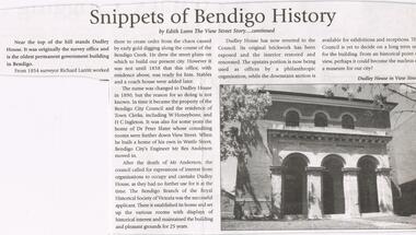
BHS CollectionBendigo Weekly date unknown. '' Snippets of Bendigo history'' by Edith Lunn the View Street story continued. In this article Edith Lunn describes Dudley House, originally the survey office and the oldest permanent government building in Bendigo. From 1854 surveyor Richard Larritt worked there. It was in 1890 that the name Dudley house was attached to the building. Town clerks W. Honeybone and H.C. Inleton lived there. Later it was the home of Dr. Peter Slater, after he moved out city engineer Mr. Rex Anderson moved in. After his death the Bendigo branch of the Royal Historical Society of Victoria established its home there after 25 years Dudley House reverted to the Council. The clip is in a folder.newspaper, bendigo, bendigo weekly -
 Melbourne Legacy
Document - Eulogy, Legatee Francis John Doolan
Information on the life of Legatee Frank Doolan from a eulogy in 1988. Legatee Doolan was a very active Legatee, starting within the first year of Legacy when he was nominated by Bill Laver and Charles Copp in 1924. While he never sought 'office but he was always there - in the background - able and willing to actively serve'. In World War 1 he enlisted in November 1917 and served with 1st Division Signal Company and in France. After Armistice he attended a course for young AIF surveyors at the British Ordnance Headquarters at South Hampton designed to bring skills back to Australia. Famously it was Frank that proposed that the spirit of Legacy is service to the widows and children. "Here it received its soul. The thoughts transmitted to the Board by this quiet man." He was Legacy's link to the Big Brother movement that was sponsoring bereft children in England to be sympathetically housed in Australia. He was a foundation member of the the first boys' gymnasium class and of the literary and debating class. He worked with the Intermediate Legacy Club for it's entirety He was part of the Legacy team who worked enthusiastically for the establishment of the Shrine. It was his technical skill as a surveyor that enabled the ray of light to shine on the Stone of Remembrance at 11 am on 11th November. Also to solve the complication of daylight saving in 1976 by positioning two mirrors. For this he was awarded the British Empire Medal. Born in 1896 at Armadale he was educated in Ballarat and South Melbourne. He obtained his qualification as a licensed surveyor at the Working Men's College (now RMIT) in 1919 on returning from war. He was partner in 'Doolan and Goodchild' through the hardships of the Great Depression. Then joined firm of Mendell, Gillespie and Charleman - being supported by Legatee Jim Gillespie. He went on to Lecturer of surveying at the Working Men's College from 1926 to 1938. Then he was assisted by Legatee Alan Murray to a position with the Valuers Section of the Department of Interior. In 1953 he was promoted to be Chief Property Officer for Victoria retiring in 1961. The page from the Bulletin from 18 August 1988 shows the names of many donors that had paid tribute to Frank. A few sentiments were included by some: 'A quiet, loveable and outstanding Legatee.' 'He was my friend, guide and mentor during the 14 happy years I spent in Legacy.' The information was part of an album of past presidents from 1965 to 1989. The folder included biographical details and obituaries, eulogies and death notices of prominent Legatees. The items have been catalogued separately.Part of the collection of material held by Melbourne Legacy on Legatee Frank Doolan a prominent member of Legacy. The information was collected to record the lives of prominent legatees in a folder.Typed A4 document x 2 pages of the life of Legatee Frank Doolan and one page from the Bulletin with donations received in his memory.eulogy, frank doolan, ray of light, shrine of remembrance, ilc, donations -
 Warrnambool and District Historical Society Inc.
Document, Allan’s Ford Bridge 1852, 1852
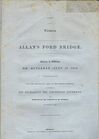
This is an original Victorian Government document containing the printed version of 37 reports and letters regarding the building of the first Allansford bridge completed early in 1852. The correspondence dates from October 1850 to February 1852 and includes letters and reports from Melbourne Government employees such as Robert Hoddle, Chief Surveyor, David Lennox, Superintendent of Bridges and Lieutenant – Governor Charles La Trobe. The correspondence from local settlers included the names of William and John Allan, John Davidson and James Coulstock. The correspondence shows that some settlers in the Warrnambool/Port Fairy district wanted a portion of the Government allocated funds spent on the local roads and bridges in other locations. The 1852 Allansford bridge cost £480 and was replaced in 1870. This document has strong historical significance as it relates to one of the earliest State government works in the district and records the public imput into the decision.. It contains opinions and correspondence between a number of early settlers in the district at the time.Grey/blue paper document with black text. 21 pages plus 4 page index at back.allan's ford 1852, allansford bridge, allansford, history of allansford, warrnambool -
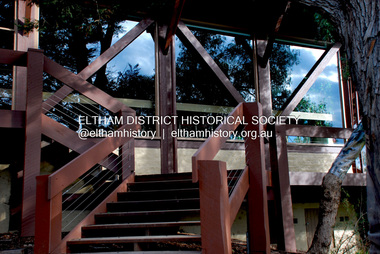 Eltham District Historical Society Inc
Photograph - Digital Photograph, Jim Connor, Eltham Community and Reception Centre, 801 Main Road, Eltham, 9 July 2008
The Eltham Community and Reception Centre was Australia's first public mud-brick building. Commissioned in 1977 by Eltham Shire Council, led by Shire president (and architect) Robert Marshall, architects Whitford and Peck were asked to design a multipurpose facility in mud-brick and timber. The official opening was performed by the Hon. R.J. Hamer; E.D., M.P., Premier of Victorai on Saturday, April 22, 1978. Architects: Whitford & Peck Pty Ltd Quantity Surveyor: D.J. Cant & Associates Structural Civil Engineers: Charlett & Moore Pty Ltd Landscape: Peter Glass, Dennis Edwards Mech Elec: Lobley Treidel & Partners Pty Ltd Acoustics: Riley Barden & Kirkhope Builder: L.U. Simon Pty Ltdjim connor collection, eltham community and reception centre, eltham community centre, mudbrick construction -
Glenelg Shire Council Cultural Collection
Photograph - Photograph - Warrane, Portland, n.d
'Warrane' is a substantial double story residence at 35 – 37 Henty Street and was erected c 1855 for Lindsay Clarke, a local architect and surveyor, Clarke is recorded in the 1857 rate book as the owner /occupier of the premises which it appears to incorporate an earlier single story stone cottage extent on the same site in 1853.The design of the house is centered around eight gables , all identical in size, two on each facade and the street front was originally sheltered by a single story veranda. The stone work in the building is finely executed with dressed stone moldings around all the principal openings. The home is an exceptionally unusual design and is possibly unique in Victoria for its period. The finely executed stone work and overall intactness give added significance.'Warrane' 35 Henty St Portland (now known as 'The Finials'. Also shows building on its western side. Reproduced from small snapshot photo -
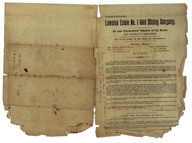 Federation University Historical Collection
Document, Lawaluk Estate No. 1 Gold Mining Company Prospectus, 1934, 26/06/1934
Prospectus for the Lawaluk Estate No. 1 Gold Mining Company Prospectus, 1934 squire, r.b. squire, lawalul estate no. 1 gold mining company, mining, shares, william collard smith, g.b. hogg, j.b. regan, s. maddison, r.t> moore, kames clements, h.a. o'connor, w.e. watts, d. fitzpatrick, lawaluk estate, mt lawaluk, robert allan, surveyor, leigh river -
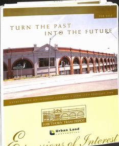 Melbourne Tram Museum
Document - Folder with papers, Urban Land corporation, "Hawthorn Tram Depot - Expressions of Interest Documentation", late 1998
White two spring clip folder with papers, titled "Hawthorn Tram Depot - Expressions of Interest Documentation", sub-titled "Turn the Past into the Future" Has a photo of Hawthorn Tram depot and an image on the front cover. Closing date 17/2/1999, prepared by the Urban Land Corporation with the assistance of VicTrack. Approx 110 pages with supplementary papers in the end covers. Contains a table of contents, checklist, EOI Process, Development Brief, Site conditions. Gives details of the heritage registration, site plans, building plans, property title and detailed room condition and use of the ground floor. Supplementary papers include the marketing brochure, letters and a detail feature and level survey by Bosco Johnson surveyors, 30-9-1998.trams, tramways, htt, hawthorn tram depot, sale of land, property -
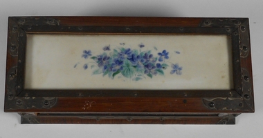 Bendigo Historical Society Inc.
Memorabilia - WOODEN BOX KNOWN AS THE 'VIOLET BOX', BENDIGO SURVEY OFFICE MR. BLACK
Wooden box inlaid on top and front with hard white material (unknown) printed with sprays of violets. Box has metal decoration: images of violets surrounded by metal edging, ornate corner scrolls. Written on piece of paper stuck inside box: 'The Violet Box. This box is a relic of Bendigo Survey Office where the Pinniger family lived from 1878 to 1890. The box originally belonged to a Mr. Black, who with Grandfather (T.W. Pinniger) and the others, Messrs. Allen and Turton, did the first geodetic survey of Victoria. To be given to Bendigo Historical Society' Newspaper article (Bendigo Advertiser July 16, 2009, by Jim Evans) included in enclosure relates to the 'Violet Box', and other early surveyors such as Richard Larritt.bendigo, sandhurst, geodetic, survey, pinniger, black -
 Eltham District Historical Society Inc
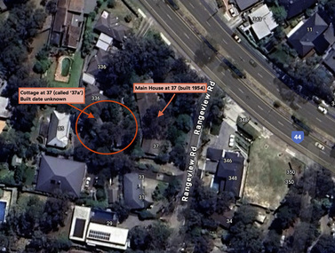
Document - Property Binder, 338 Main Road, Lower Plenty (also 37 Rangeview Road), March 2025
EDHS_03095-338 | EDHS_08635-37 338 Main Road Lower Plenty | 37 Rangeview Road, Lower Plenty Original Mudbrick cottage and studio designed and built by Eltham artist, David Alan Newbury See also EDHS_06090 David Newbury (Artist) David Newbury was married to Clare Margaret Newbury. According to the 1954 Electoral Roll they were living at 36A Murphy Street, South Yarra however around 1953 they purchased Lots 3 and 4 of Main Road Lot Plan LP 23911 in Lower Plenty. A building permit, No. 71, was issued 8 December 1953 for a 5-room house of Vertical Board construction, cost £2,840, builder L. Williams, owner D. Newbury of 36 Murphy Cl., South Yarra. The large house was in fact mostly built of mudbrick, the construction method was only just becoming recognised as an acceptable form in the late 1940s for issuance of a building permit. The house was commenced in 1954, designed by David Newbury and built by David Newbury, Horrie Judd and others. Information from Newbury family friends suggests that a second mudbrick building was constructed in the late 1950s, early 1960s for use as an artist studio by Newbury. The building was connected directly to the water mains at the time and was made suitable for living accommodation during the period Newbury was teaching at Bendigo. Apparently he and Claire rented out the main house during their time in Bendigo and would reside in the studio when visiting Melbourne. No permit for this studio was found in the Building Permit Register, Shire of Eltham, 1949-1960. The last recorded entries in the register are dated May 1960. This would suggest that the studio was constructed post May 1960. It is believed the studio was constructed during the latter period of Newbury’s teaching post in Bendigo so possibly late 1960/1961. In 1963 the Newbury’s address in the Electoral Roll has the property recorded as 220 Main Road, Lower Plenty. Between 1967 to 1980 the Electoral Rolls record the property as 338 Main Road. Today the address is 37 Rangeview Road, Lower Plenty. Contents: 1. Extract from 1942 Shire of Eltham Rate Book. Muriel Gladys Reitsma listed as owner 2. Extract from 1984-85 Shire of Eltham Rate Book for Rangeview Road. (No mention of No. 37 so was probably still listed as 338 Main Road.) 3. Certificate of Title, Vol. 5601 Fol. 1120089 - Issued to David James Graham of Lower Plenty, Builder, Heidelberg for Lot 32 Block B on Plan of Subdivision No. 7606, part of Crown Portion Two, Parish of Nillumbik, County of Evelyn, 29 October 1929 4. Certificate of Title, Vol. 8008 Fol. 076 - Issued to David Alan Newbury of 36 Murphy Street, South Yarra, School Teacher for Lot 3 on Plan of Subdivision No. 23911, part of Crown Portion Two, Parish of Nillumbik, County of Evelyn, 29 October 1953. Amended 24 June 1963 to transfer portion for road widening scheme per Country Roads Board Plan 6889 - Cancelled 24 September 1984 5. Certificate of Title, Vol. 9581 Fol. 583 - Issued to Paul Robert Biber and Althea Constance Biber of 139 Lower Heidelberg Road, Ivanhoe for Lot 3 on Plan of Subdivision No. 23911, part of Crown Portion Two, Parish of Nillumbik, County of Evelyn, 24 September 1984. Derived from Vol. 8008 Fol. 076 L276994V - Cancelled 20 Nov 1992 when subdivided from one to two lots in Vol 10092 Fol. 192 and Vol. 10092 Fol. 193; LP222467B 6. Certificate of Title, Vol. 10092 Fol. 192 - Transfer to Lawrie Mein of 20 Dewar Drive, Hurstbridge of Lot 1 on Plan of Subdivision No. 222467B, lodged 17 Feb 1993, Registered 29 March 1996. Parent Titles Vol 08008 Fol 077, Vol 09581 Fol 583 7. Survey Field Notes of Part of Crown Portion 2, Parish of Nillumbik, County of Evelyn - Portion of land bounded by New Eltham Road. Application 23911 dated 8 Sep 1952 with appended Surveyor Field notes per Application 7098; R.D. Steele, Licensed Surveyor, 18 August 1950 8. Survey Field Notes of Part of Crown Portion 2, Parish of Nillumbik, County of Evelyn - Portion of land bounded by Main Road and Rangeview Road; 2 Lot subdivisions, Vol. 9581 Fol. 583 Part Lot 3 on LP 23911 and Vol. 8008 Fol, 077 Lot 4 on LP 23911; Application 221805 dated 27 November 1989; W.J. Goodison, Licensed Surveyor, and attached Surveyor's Report dated 6 June 1990 (Withdrawn) 9. Survey Field Notes of Part of Crown Portion 2, Parish of Nillumbik, County of Evelyn - Portion of land bounded by Main Road and Rangeview Road; 2 Lot subdivisions, Vol. 9581 Fol. 583 Part Lot 3 on LP 23911 and Vol. 8008 Fol, 077 Lot 4 on LP 23911; Application 222467 dated 20 November 1992 (221805 resubmitted); W.J. Goodison, Licensed Surveyor, and attached Surveyor's Report dated 6 June 1990 Notes: Items 1 to 6 donated electronically Items 7 to 9 sourced from LASSI - SPEAR, Department of Transport and Planning, Victoria State Government, https://maps.land.vic.gov.au/lassi/SpearUI.jsp main road, property, mudbrick, david newbury, phoebe mason collection, rate books, shire of eltham, certificate of title, survey plan, 37 rangeview road, 338 main road, application 23911, lower plenty, map, surveyor field notes, application 221805, application 222467 -
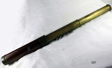 Flagstaff Hill Maritime Museum and Village
Telescope, 1780-1820
Not much is known about William Rothwell other than he is recorded as working as an optician and scientific instrument maker in Manchester at 277 Deansgate Street from 1780 until 1820. An entry in the “Complete History of the Trades of Manchester” published in 1822, in which the author describes Mr William Rothwell as an intelligent young man who is conversant in several languages. He went on to describe him as an philosophical instrument maker of optical and mathematical objects, specialising in spectacles, all sorts of surveyors instruments as well as eye glasses of all types. At present that is all that is known of William Rothwell other than his products were made to the highest standards of the time. Today his products are now actively sought by collectors and are currently fetching high prices at auction sales overseas. The telescope is a rare item even though not much is known about Rothwell's history his scientific instruments and optical items fetch high prices when they become available as collectors look for rare and well made items from the 18th and 19th centuries. Its completeness and good condition make it a very good addition to the collection at Flagstaff Hill. A three draw military telescope brass with main cylinder section made of wood, main lens is removable for cleaning.Marked "Rothwell, Manchester"flagstaff hill, warrnambool, shipwrecked-coast, flagstaff-hill, flagstaff-hill-maritime-museum, maritime-museum, shipwreck-coast, flagstaff-hill-maritime-village, telescope, william rothwell, scientific instrument, manchester optician, optician -
![H.H. Harrison, Town Clerk [of Kew] 1901-1938](/media/collectors/550653872162f11fb04854aa/items/5922c035d0cde9131c3555a9/item-media/5c2269b021ea6913f4577219/item-fit-380x285.jpg) Kew Historical Society Inc
Kew Historical Society IncPhotograph, H.H. Harrison, Town Clerk [of Kew] 1901-1938, 1930s
Cr. W.D. Vaughan in his civic history of Kew includes a chapter (XXXII, pages 132-3) to Town Clerks and Surveyors. He states that H.H. Harrison began his career with the Borough of Kew in 1888 as his predecessor's assistant, becoming Town Clerk on the latter's death in 1901. On his retirement, The Herald on 30 Jul 1938 reported that: "H.H. HARRISON, Town Clerk of Kew, was entertained last night by members of the Metropolitan Institute of Town Clerks and presented with a walking stick and case of pipes, on the occasion of his retirement after 50 years' service with Kew City Council. He began his municipal career as a youth with the Bendigo City Council, and in 1888, was appointed Assistant Town Clerk at Kew. Appointed Town Clerk in 1901, he has held the office for 37 years."This portrait is one of a series of mounted and framed photographic portraits of Mayors and Town Clerks of the former Borough, Town and City of Kew, for the period 1863 to 1969. The portraits were transferred by the City of Kew to the Kew Historical Society in March 1989. A Significance Assessment in 2018, funded by the National Library of Australia confirmed the historic, and often artistic significance of the series. Framed portrait of Henry Hirst Harrison, Town Clerk of the City of Kew from 1901 to 1938. The mounting and framing of the photograph follows a typical layout or style in that it each is framed in dark wood, glazed, and laid down on an inscribed board. The inscription identifies the name of the town clerk and the year/s that he served.H.H. Harrison, Town Clerk 1901-1938h.h. harrison, town clerks - kew (vic), kew (vic.) — municipal collection -
 Flagstaff Hill Maritime Museum and Village
Map - Survey Map, F.F. McGovern, Yangery - County of Villiers, 1884
A surveyor was employed to measure the land designated as Yangery, County of Villiers, in the Borough of Warrnambool. The area on the map is similar to the earlier Farnham Survey undertaken by William Rutledge in the 1850's. Warrnambool was a Borough between 1863-1883. Coutours, waterways, sea and other significant points are shown. The distances are accurately measured. This survey map was used for planning future land sales, recreation areas and roads. WILLIAM RUTLEDGE (1806-1876) William Rutledge surveyed the land known as Farnham in southwest Victoria in 1843. His tenants made him a profitable business from working the land there. In 1863 Rutledge moved from nearby Port Fairy to Farnham and became very successful in breeding sheep, which he imported from J.R. Kirkham of Lincolnshire, England. He also bred horses on his land. The survey map of Yangery is important for its connection with renowned surveyor William Rutledge. The map shows the growth of landholders in the district when compared to the original Rutledge survey of the 1850's.Survey map of Yangery, titled "Yangery - County of Villiers". Printed on white paper, mounted on brown paper. c. 1863-1876. Comments printed on the Map include; Special Survey by William Rutledge, Photo-lithographed at the Department of Lands and Survey, Melbourne by W.J. Burson, Price 1/- [one shilling]. Scale is in Chains. Map has boundaries of Koroit Borough, Meerai, Purnim, Wangoom, Borough of Warrnambool, Mentions the Proposal of Tower HIll for Public Recreation. The map names the owners of the land at that time. Hand written pencil marks and figures and "Sauls fence" drawn on map. Hand written pencil markes and figures and "Sauls fence" drawn onto map. "For Department Use only". "Scale: 8 chains to 1 inch" flagstaff hill, warrnambool, shipwrecked-coast, flagstaff-hill, flagstaff-hill-maritime-museum, maritime-museum, shipwreck-coast, flagstaff-hill-maritime-village, county of villiers map, yangery district, w.j. burson, borough of warrnambool, koroit, purnim, meerai, wangoom, proposal of tower hill for public recreation, special survey by william rutledge, william rutledge, farnham, lincolnshire sheep, clydesdale -
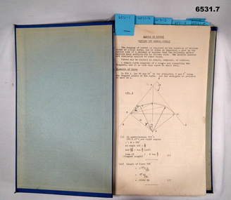 Bendigo Military Museum
Booklet - Royal Australian Survey Corps - School of Military Survey Precis - Formula for Survey Calculations, School of Military Survey, Balcombe, Circa 1960s
This selection of Precis was produced by the Royal Australian Survey Corps, School of Military Survey, Balcombe, circa 1960s. The Precis are intended to instruct RASvy Surveyors employed on Engineer/ Field Survey Tasks on the calculations necessary for Surveying formula. The blue hard covered foolscap sized booklet held together with two Chicago screws contains 7 x precis listed below. .1 Setting out simple Curves .2 Earthworks .3 Calculation of area by double Latitude .4 Notes on Station Adjustment by Least Squares .5 Notes on Figure Adjustment by Least Squares .6 Technical Memo No1, Computation of Tellurometer Traverses using Plain Angles and Plain Distances by WO2 R Wilson RASvy (later Major) .7 Computing Traverses in Plane CoordinatesBlue Hard covered foolscap sized booklet held together with two Chicago screws. Booklet contains 7 x precis. .1 Setting out simple Curves .2 Earthworks .3 Calculation of area by double Latitude .4 Notes on Station Adjustment by Least Squares .5 Notes on Figure Adjustment by Least Squares .6 Technical Memo No1, Computation of Tellurometer Traverses using Plain Angles and Plain Distances by WO2 R Wilson (later Major) .7 Computing Traverses in Plane Coordinatesroyal australian survey corps, rasvy, fortuna, army survey regiment, army svy regt, asr, school of military survey -
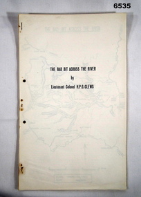 Bendigo Military Museum
Journal - Royal Australian Survey Corps - The Bad Bit Across the River - LtCol HPG Clews 1934, LTCol HPG Clews RASvy, 1934
This Journal "The bad bit across the River" was written by - LtCol HPG Clews in 1934 and is about his experiences around the Colo River approximately 60 miles NW of Sydney, NSW. LtCol Clews was a remarkable man and his achievements were just as remarkable. He is affectionately known as "The Major." He served in the British Army 1909 - 1911 with the Sherwood Foresters. He then served in the Royal Australian Survey Corps from 1912 - 1949 and then served as the Senior Surveyor with the Snowy Mountains Authority from 1950-1958. A Survey Cairn is errected in Khancoban to record his life 1890 - 1980. This Journal records the field trip to establish Survey Control in very rugged country by a handful of party members on foot. The map shows the routes taken.14 x foolscap pages stapled and two hole punched. The Journal includes a map, 7 x pages of typed text and 4 x Annexesroyal australian survey corps, rasvy, fortuna, army survey regiment, army svy regt, asr, 2nd field survey company -
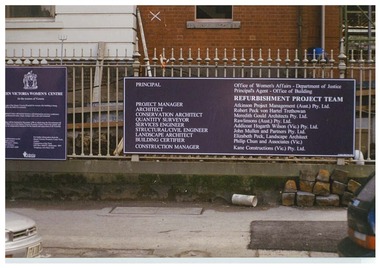 Queen Victoria Women's Centre
Photograph, c.1995/1996
Colour photograph. The board which was outside the QVWC building's gates on Lonsdale street. which details main groups involved in refurbishment of the building. "Principle: Office of Women's Affairs - Department of Justice. Principle Agent - Office of Building. Refurbishment Project Team. Project manager: Atkinson Project Management (Aust.) Pty. Ltd. Architects: Robert Peck won Hartel Trethowan. Conservation Architect: Meredith Gould Architects Pty. Ltd. Quantity Surveyor: Rawlinsons (Aust.) Pty. Ltd. Services Engineer: Addicoat Hogarth WIlson (Vic) Pty. Ltd. Structural/Civil Engineer: John Mulle and Partners Pty. Ltd. Landscape Architect: Elizabeth Peck, Landscape Architect. Building Certifier: Philip Chun and Associates (Vic.) Construction Manager: Kane Constructions (Vic.) Pty. Ltd."historic buildings, building construction -
 Forests Commission Retired Personnel Association (FCRPA)
Gunter's Chain
Before metrication was introduced into Australia in the 1970s land was measured in chains and links. Many old parish plans show length measurements in chains and links. Area was shown in acres, roods and perches. Gunter's chain was used for measuring distance in surveying. It was designed and introduced in 1620 by English clergyman and mathematician Edmund Gunter (1581–1626). Gunter developed the measuring chain of 100 links. The chain and the link, became statutory measures in England and subsequently the British Empire. After metrication units of length were measured in meters and area in hectares. The chain was later superseded by steel ribbon tape.The 66 foot long brass Gunter's Chain is divided into 100 links (each 7.92 inches long), and marked off into groups of 10 by shaped tags which simplify intermediate measurement. It was heavy but flexible enough to be dragged through the bush on surveying transects.(Hence the common forestry term "chainman). The chain was a precision part of a surveyor's equipment. It required frequent calibration, yet needed to be sturdy enough to be dragged through rough terrain for years. It has brass hand grips at each end of chain. 1 chain = 100 links = 22 yards = 66 feet = 792 inches. 10 chains = furlong 80 chains = 1 mile 1 acre = 10 square chains = 4 roods (1/4 acre) = 40 perches.forest measurement, surveying, forests commission victoria (fcv) -
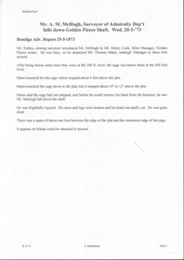 Bendigo Historical Society Inc.
Document - MINING ACCIDENTS - MAN FALLS DOWN GOLDEN FLEECE SHAFT
Handwritten extract from the Bendigo Advertiser dated 29/5/1873. Mr. A. M. McHugh, Surveyor of Admiralty Dep't fell down the Golden Fleece Shaft on 28/5/73. The undergr'd Manager, Mr. Thomas Mann, was showing him around. They had been at the 300 ft level and the cage was below them. Mann knocked for the cage which stopped about four feet above the plat. Mann knocked the cage down, but it stopped about 10' or 12' above the plat. Mann said the cage had not stopped, and before he could remove his hand from the knocker, he saw Mr. McHugh fall down the shaft. He died. There was a space between the edge of the plat and innermost edge of the cage.document, gold, mining accidents, man falls down golden fleece shaft, mr a m mchugh, bendigo advertiser 29/5/1873, mr forbes, mr henry cook, mr thomas mann -
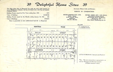 Ringwood and District Historical Society
Flyer, Subdivision advertisement for sale of home sites - Ringwood, Victoria - 1956
Cardboard-backed advertisement for 39 home sites for sale, with location map, and summary of local real estate statistics in 1955 & 1956. Handwritten date noted in top right corner - 24th March, 1956.Subdivision map includes Reilly Street, Philip Street, Lorienne Street and Daisy Street in Heathmont. Surveyors: Messrs Little and Brosnan. Agents in conjunction: Peter Martin Pty. Ltd., Estate Agents, 55-57 Latrobe Street, Melbourne (Phone) FB 3571, FB 2783, and Peter Aubin Pty. Ltd., Auctioneers & Estage Agents, 345 Lonsdale Street, Dandenong (Phone) Dandenong 340, after hours Dandenong 932, 70. -
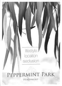 Ringwood and District Historical Society
Flyer, Residential Land Sale Brochure, Peppermint Park, Heathmont, Vic. - 2010
Double-sided A3 size advertisement for Peppermint Park, Heathmont, Victoria, advertising sale of ten homesites with diagram showing locality map, size of blocks and layout of streets within and around the subdivision.Subdivision layout includes Pleasant Drive, Swain Court and Barbara Court off Culverlands Road and Armstrong Road in Heathmont. Agents - Carter Real Estate Agency, 90 Maroondah Highway, Ringwood Vic 3134 (Telephone) 98706211. Auctioneers - Richard Carter & William Lyall - 0411823337. Handwritten price list notations included, and Stage 2 Plan digitally signed by Michael Herwald Hipfel, Licensed Surveyor, 10/2/1916. -
 The Beechworth Burke Museum
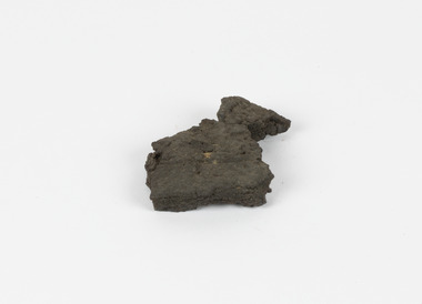
Geological specimen - Brown Coal
Brown Coal is typically found as rocks. During formation the Brown Coal starts as peats, which is an acidic brown deposit resembling soil, and over time when subjected to pressure and heat these peats form the Coal. Brown Coal is the lowest rank of coal as it has a low carbon (energy) content, and a high moisture content. This high moisture content makes Brown Coal unsuitable for overseas exports. This particular specimen was recovered from the Yallourn Mine in Latrobe Valley, Victoria as part of the geological survey of Victoria being carried out by Alfred Selwyn. Otherwise known as the 'Yallourn Power Station', the Yallourn Mine is Australia's second largest mine. Yallourn Mine was first built in 1920, and since then it has been providing over 1 billion tonnes of Brown Coal to Australia every year. The Yallourn Mine is responsible for 22% of Victoria's electricity and 8% of Australia's electricity. As of 2021 the mine employs around 500 people. Due to ongoing maintenance issues and Australia's move to cleaner energy, the Yallourn Mine intends to shut down permanently as of 2028. Soon after gold was discovered in 1851, Victoria’s Governor La Trobe wrote to the Colonial Office in London, urging ‘the propriety of selecting and appointing as Mineral Surveyor for this Colony a gentleman possessed of the requisite qualifications and acquaintance with geological science and phenomena’. Alfred Selwyn was appointed geological surveyor in Australia in 1852 which began the Geological Survey of Victoria. In 1853-69 the Geological Survey issued under Selwyn's direction sixty-one geological maps and numerous reports; they were of such high standard that a writer in the Quarterly Journal of the Geological Society of London bracketed the survey with that of the United States of America as the best in the world. During his years spent in Australia, Selwyn collected numerous significant geological specimens, examples of which are held in collections such as the Burke Museum.Brown coal is considered to be an essential rock to Australia's energy consumption. Although plentiful in sources, Brown Coal is not able to be exported overseas due to its high moisture content. As Australia moves towards cleaner energy, Brown Coal is going become less used. This specimen is part of a larger collection of geological and mineral specimens collected from around Australia (and some parts of the world) and donated to the Burke Museum between 1868-1880. A large percentage of these specimens were collected in Victoria as part of the Geological Survey of Victoria that begun in 1852 (in response to the Gold Rush) to study and map the geology of Victoria. Collecting geological specimens was an important part of mapping and understanding the scientific makeup of the earth. Many of these specimens were sent to research and collecting organisations across Australia, including the Burke Museum, to educate and encourage further study.A solid hand-sized sedimentary rock that is a dark shade of brown.13 / BROWN COAL / Showing Woody structure / Locality: Yallourn, Vic. | Label probably / correct but / can't find reference / no. 13 to match in / registers. / C Willman / 15/4/21burke museum, beechworth, indigo shire, beechworth museum, geological, geological specimen, mineralogy, yallourn, yallourn mine, victoria, coal, brown coal, brown coal specimen, alfred selwyn, geological survey of victoria, geological survey, yallourn power station -
 Melbourne Legacy
Document - Eulogy, A tribute to Legatee Frank Doolan
Information on the life of Legatee Frank Doolan from the memorial service held for him in 1988. Legatee Doolan was a very active Legatee, starting within the first year of Legacy when he was nominated by Bill Laver and Charles Copp in 1924. While he never sought 'office but he was always there - in the background - able and willing to actively serve'. In World War 1 he enlisted in November 1917 and served with 1st Division Signal Company and in France. After Armistice he attended a course for young AIF surveyors at the British Ordnance Headquarters at South Hampton. Famously it was Frank that proposed that the spirit of Legacy is service to the widows and children. "Here it received its soul. The thoughts transmitted to the Board by this quiet man." He was part of the Legacy team who worked enthusiastically for the establishment of the Shrine. It was his technical skill as a surveyor that enabled the ray of light to shine on the Stone of Remembrance at 11 am on 11th November. Also to solve the complication of daylight saving by positioning two mirrors . For this he was awarded the British Empire Medal. He was involved in the purchase of Legacy House in 1955 and also in the Lone Pine project in 1964. In a final story the speaker mentions Frank acquired a race horse called Tamwill from the estate of a mate. It gave him great pleasure for years and poignantly died the day before Frank passed away. The card sent as a thank you from the family includes hand written text to Wendy (Faulkner, staff member at Legacy) from Geoff Doolan, son of legatee Frank Doolan. The information was part of an album of past presidents from 1965 to 1989. The folder included biographical details and obituaries, eulogies and death notices of prominent Legatees. The items have been catalogued separately.Part of the collection of material held by Melbourne Legacy on Legatee Frank Doolan a prominent member of Legacy. The information was collected to record the lives of prominent legatees in a folder.Typed A4 document x 5 pages of the life of Legatee Frank Doolan. Pus a memorial card from the family.eulogy, frank doolan, ray of light, shrine of remembrance, lone pine -
 Melbourne Legacy
Document - Speech, A tribute to Legatee Frank Doolan
Information on the life of Legatee Frank Doolan from a dinner held to celebrate his 50 years of service on 27 May 1974 at the Oakleigh and Waverly Branch. Speakers included President Bill Braidie, Legatee Jim Gillespie and Legatee Frank Doolan. Frank recalls how he delivered the Toast to Legacy at the Perth Conference. In it he likened Legacy to a valuable cloak with foundations of gold and silver laid down by the founders, and additional threads added by successive legatees to become what the public see today. Legatee Doolan was a very active Legatee, starting within the first year of Legacy when he was nominated by Bill Laver and Charles Copp in 1924. While he never sought 'office but he was always there - in the background - able and willing to actively serve'. In World War 1 he enlisted in November 1917 and served with 1st Division Signal Company and in France. After Armistice he attended a course for young AIF surveyors at the British Ordnance Headquarters at South Hampton. Famously it was Frank that proposed that the spirit of Legacy is service to the widows and children. "Here it received its soul. The thoughts transmitted to the Board by this quiet man." He was part of the Legacy team who worked enthusiastically for the establishment of the Shrine. It was his technical skill as a surveyor that enabled the ray of light to shine on the Stone of Remembrance at 11 am on 11th November. Also to solve the complication of daylight saving by positioning two mirrors. For this he was awarded the British Empire Medal. He was involved in the purchase of Legacy House in 1955 and also in the Lone Pine project in 1964. He was also established an archive at Legacy House to try and capture the history of Legacy. The information was part of an album of past presidents from 1965 to 1989. The folder included biographical details and obituaries, eulogies and death notices of prominent Legatees. The items have been catalogued separately.Part of the collection of material held by Melbourne Legacy on Legatee Frank Doolan a prominent member of Legacy. The information was collected to record the lives of prominent legatees in a folder.Typed A4 document x 5 pages of the life of Legatee Frank Doolan. frank doolan, ray of light, shrine of remembrance, lone pine -
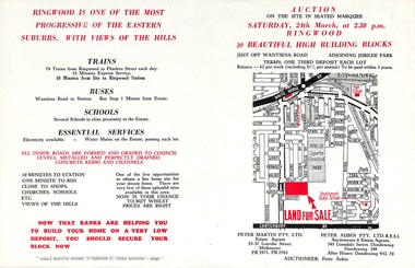 Ringwood and District Historical Society
Flyer, Land Auction Advertisement adjoining Jubilee Park, Ringwood, Victoria - 1956
Folded double-sided brochure advertising residential land sale auction on Saturday 24th March (1956), with locality map and subdivision layout, terms of sale, and summary of local features and services. Subdivision includes Reilly Street Ringwood, and Philip Street, Daisy Street, and Lorienne Street Heathmont. Surveyors - Messrs Little and Brosnan. Agents in Conjunction - Peter Martin Pty. Ltd., Estate Agents, 55-57 Latrobe Street, Melbourne (Phone) FB 3571, FB 2783, and Peter Aubin Pty. Ltd. R.E.S.I., Auctioneers & Estate Agents, 345 Lonsdale Street, Dandenong (Phone) Dandenong 340, After Hours, Dandenong 932, 70. -
 Ringwood and District Historical Society
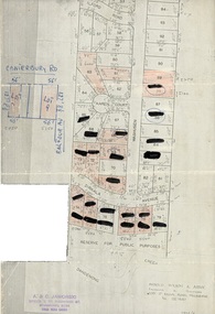
Document, Map showing numbered subdivision allotments with hand-written notations and redactions - 1924
Foolscap size page Map by Arnold Wilson & Associates, Engineers & Surveyors, 399 St.Kilda Road, Melbourne, Tel 26-1840 - 1924/4. Subdivision includes Ilford Road, Karen Court, Washusen Road and Dirkala Avenue, Heathmont. Also includes hand-drawn allotments on Canterbury Road and Balfour Avenue. Page rubber-stamped by building company A & C Jaworski, Office 2, 23 Ringwood Street, Ringwood 3134, Tel 870-0820, A.H. 870-2062. -
 Ringwood and District Historical Society
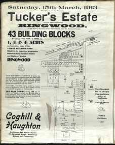
Card - Land Subdivision Clipping, Tucker's Estate, Ringwood, Vic. - 1913
Partially trimmed copy of a land subdivision auction advertisement on cardboard backing, with digitised copy of original flyer.Subdivision includes Thanet Street, Albert Street, Arlington Street, Barkly Street, Maidstone Street, Kirk Street, Vine Street, Surrey Street, Yarmouth Street and West Prussia Road (later Wantirna Road) Ringwood, Vic. Property names include Wandsworth, Ingleside, Lyndhurst and Karsruhe. Auctioneer and Estate Agents - Coghill & Haughton, 79 Swanston Street, Melbourne Auburn and Canterbury. Licensed Surveyor - W.P. Steane, M.C.E., 317 Collins Street, Melbourne. -
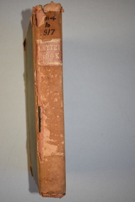
 Warrnambool and District Historical Society Inc.
Ledger, Chadwick Copying Book Co, Letter book 1905, 1902
This letter book has maps, letters and plans dating from 1902 to 1905. It came from the office of John William Crawley, Junior, an engineer, architect and surveyor in private practice in Warrnambool and also the engineer for the Shire of Warrnambool from 1895 to 1935. His father, brother and son were all engineers and worked in that capacity or as Shire Secretary for the Shire of Warrnambool, with the Crawley family recording a total of 132 years of service to the Shire of Warrnambool. The Shire of Warrnambool existed from 1863 to 1994. This letter book was passed on to John Crawley’s son, Rolf, engineer for the Shire of Warrnambool from 1935 to 1968. The letter book then came into the possession of Michael Hand who took over the private surveying business of Rolf Crawley in Warrnambool. The Warrnambool and District Historical Society acquired the letter book, along with several other Crawley ledgers, from the Michael Hand estate. This letter book is of considerable importance as it contains the letters, maps and plans produced by John William Crawley Junior, a Shire of Warrnambool engineer for 40 years. It will be useful to researchers. This is a black hard cover letter book of 505 pages, plus an alphabetical index at the back of the book. The letter book contains handwritten letters, sketch maps and plans. There is gold lettering on the spine.‘1’ ‘Invoice’ ‘Chadwick Copying Book Co. Springfield Mass.’ john william crawley, junior, warrnambool, rolf crawley, warrnambool, shire of warrnambool, history of warrnambool -
 Warrnambool and District Historical Society Inc.
Letter book 6, Jan 1914 - 1917, 1914
This letter book contains letters, plans and sketch maps dating from 1914 to 1917. It came from the office of John William Crawley Junior, an engineer, architect and surveyor in private practice in Warrnambool and also the engineer for the Shire of Warrnambool from 1895 to 1935. His father, brother and son were also engineers and worked in that capacity or as the Shire Secretary for the Shire of Warrnambool, with the Crawley family recording a total of 132 years of service to the Shire of Warrnambool. This Shire existed from 1863 to 1994. The letter book was passed on the John Crawley’s son, Rolf, engineer for the Shire of Warrnambool from 1935 to 1968. It then came into the possession of Michael Hand who took over the private surveying practice of Rolf Crawley in Warrnambool. The Warrnambool and District Historical Society has acquired the letter book, along with several other Crawley ledgers, from the Michael Hand estate. This letter book is of considerable significance as it contains letters, maps and plans drawn up by John William Crawley, Junior, the engineer for the Shire of Warrnambool for 40 years. It will be very useful for researchers. This is a brown hard cover letter book with leather binding on the edges of the cover and on the spine. The leather is worn away in several places. There is gold lettering on the spine. The book has 750 pages of handwritten letters, maps and plans. The inside cover is of a mottled blue colour. There is an alphabetical index at the beginning of the book. ‘6’ ‘Letter Book 1914 to 1917’ john william crawley junior, warrnambool, rolf crawley, warrnambool, shire of warrnambool