Showing 8872 items matching " construction"
-
 Kew Historical Society Inc
Plan, Melbourne & Metropolitan Board of Works : Borough of Kew : Detail Plan No.1572, 1905
The Melbourne and Metropolitan Board of Works (MMBW) plans were produced from the 1890s to the 1950s. They were crucial to the design and development of Melbourne's sewerage and drainage system. The plans, at a scale of 40 feet to 1 inch (1:480), provide a detailed historical record of Melbourne streetscapes and environmental features. Each plan covers one or two street blocks (roughly six streets), showing details of buildings, including garden layouts and ownership boundaries, and features such as laneways, drains, bridges, parks, municipal boundaries and other prominent landmarks as they existed at the time each plan was produced. (Source: State Library of Victoria)This plan forms part of a large group of MMBW plans and maps that was donated to the Society by the Mr Poulter, City Engineer of the City of Kew in 1989. Within this collection, thirty-five hand-coloured plans, backed with linen, are of statewide significance as they include annotations that provide details of construction materials used in buildings in the first decade of the 20th century as well as additional information about land ownership and usage. The copies in the Public Record Office Victoria and the State Library of Victoria are monochrome versions which do not denote building materials so that the maps in this collection are invaluable and unique tools for researchers and heritage consultants. A number of the plans are not held in the collection of the State Library of Victoria so they have the additional attribute of rarity.Original survey plan, issued by the MMBW to a contractor with responsibility for constructing sewers in the area identified on the plan within the Borough of Kew. The plan was at some stage hand-coloured, possibly by the contractor, but more likely by officers working in the Engineering Department of the Borough and later Town, then City of Kew. The hand-coloured sections of buildings on the plan were used to denote masonry or brick constructions (pink), weatherboard constructions (yellow), and public buildings (grey). Plan No. 1572 represents the built environment bordered by Barkers Road, Wrixon Street, Edgevale Road and Fitzwilliam Street. Other streets identified on the plan include Stansell Street. Plan 1572 shows that by 1903-05, there was only patchy development in this area of Kew, mainly on Edgevale Road and Fitzwilliam Street. Only two named houses are identified: the quaintly named ‘Tweed Cottage’, and ‘Mendip’. The earliest reference to Treed Cottage in Australian newspapers is to the death of Walter Thompson, aged 74 who was a resident there in 1885. His youngest daughter was to die there in 1908. Mendip to the north of Tweed Cottage was owned by Henry Thompson; he was to die in 1901; his wife in 1932. At this period of time, Malin Street and Clivedon Court did not extend to Barkers Road.melbourne and metropolitan board of works, detail plans, mmbw 1572, cartography -
 Mission to Seafarers Victoria
Artwork, other - Art installation, Dagmar Udhe, Leap of the Heart: Ultramarine perspex oval shape by Dagmar Udhe, 1998
See document 1507Information for the brochure (http://www.artdes.monash.edu.au/globe/issue8/tbtitle.html) Construction in Process VI The Bridge, Melbourne Event: March 21-31 1998 Exhibition April 1-30 1998 During Construction in Process (CIP) III at Lodz, Poland in 1991, Emmett Williams and other participating artists initiated the idea of a biannual "performance" of their project in different cities and sites around the world. In the first instance, CIP was a response to the strictures of museum contained commodification of art practices and the dissolution of communism. And with this agenda in mind, their events affirm the active participation of international artists with local infrastructure and site specific materials. The organisation of the 1998 CIP in Melbourne, titled "The Bridge", took Richard Thomas, Katherine Armstrong, Gail Davidson and the legion of others over two years of dedication. And they brought off one of the most open-ended, logistically challenging conceptual events this metropolis has witnessed. The following photo essay provides a personal survey of the "The Bridge", as I saw it transpire around me. German artist Dagmar Udhe created several art installation in Swanson Dock and the Mission. This plaque was placed either in the dome or outside the dome. It may have been forgotten or left intentionally by the artist.PerformanceUltramarine ovoid shaped perspex plaque attached to the wall in the entrance of the Mission (Flinders Street).art installation, dagmar udhe, cultural events, artwork-paintings -
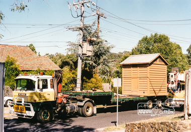 Eltham District Historical Society Inc
Photograph, Lock-up No. 17 arriving at the Local History Centre, 728 Main Road, Eltham, March 2001, March 2001
The portable lockup at Eltham is not original to the site. The date of construction is unknown, believed from the 1880s. It is a prefabricated design and each of the timber panels are individually numbered on the inside surfaces. It is amongst a large group of portable lockups, categorised as 'Portable Lock Up - Timber - Later' and also known as the "Casterton style", based on the only known plan for portable lock ups, built for the Casterton Police Station, in 1907. The later portables have been in use since the 1880s. It is not known how many lock ups of this type have been constructed in Victoria. At least 50 examples have been documented around the state. Of these, 42 are known to be extant. The original 1860s site lockup was a 2-cell bluestone construction. Some of the original bluestone remains. It was used in the 1970s as traffic island edging at the intersection of Main Road and Wattletree Road where it was painted white then later relocated back to this site in the 1980s to be used as edging for a driveway access off Main Road beside the former Police Residence where the Police Station originally stood. Evidence of some of this edging remains in place today leading to the replica Police Station. Other blocks were used to define the garden edging in the carpark at the rear of the residence.This lockup used to be located at the Police Station in Pryor Street and was then stored in Youth Road before being acquired for the Local History Centre 3 colour photographseltham, main road, police residence, local history centre, eltham district historical society, courthouse, youth road -
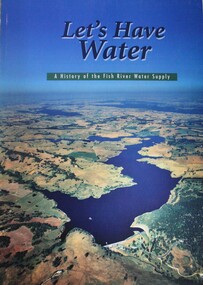 Wodonga & District Historical Society Inc
Book - Let's Have Water - A history of the Fish River Water Supply, Robin McLachlan, Denis Barrett, Jack Domis, Nick Welling, 1997
A history of the development of the management of the Fish River Water Supply Scheme in Central NSW. The scheme extends across the local government areas of the Shire of Oberon, the City of Lithgow and the City of the Blue Mountains.non-fictionA history of the development of the management of the Fish River Water Supply Scheme in Central NSW. The scheme extends across the local government areas of the Shire of Oberon, the City of Lithgow and the City of the Blue Mountains.water nsw, fish river region nsw, oberon dam, water resources development nsw australia -
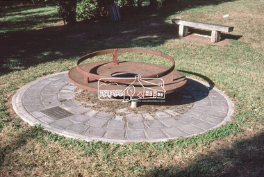 Eltham District Historical Society Inc
Slide - Photograph, Monument with time capsule, Eltham Community Centre, Main Road, Eltham, c.Mar. 1989
The monument with time capsule was established by the Shire of Eltham Historical Society to commemorate Victoria’s 150th anniversary and mark the former location of the Eltham Town Centre, which existed along this section of Main Road, then known as Maria Street. The unveiling was conducted 10 November 1985 by Cr. Mary Grant (Shire President). The monument was constructed with a concrete base and the main feature is an old tyring plate or disc. The Time Capsule Ceremony involved lowering the sealed time capsule into place, bolting down its container lid and then concreting over the lid. The capsule contains items relating to present day (1985) Eltham and its people including a video film made by Joh Ebeli and also details of families and organizations who have contributed to construction of the monument. It is to be opened in the year 2035. The Society received an excellent response from local people, firms and organizations by way of assistance with this project. Graham Beyer, who originated the project, arranged many of the donations. He and his firm, Package Handling Equipment, donated the time capsule itself and carried out fabrication of sections of the monument. The design of the monument was adapted by Graham Beyer from drawings by Joh Ebeli. Charmac Industries donated the container for the time capsule and a cast gun metal name plate for the monument. BMG Concrete donated concrete for the base which was constructed by Caridi Construction Company. Northbourne Garden Supplies donated materials for the paving around the monument. Robert Becker from Eltham Apex directed construction of the paving by Society members. Terry Hutchinson donated the use of his crane to lift the tyring disc into place. Financial contributions were also made by the Eltham Chamber of Commerce and the Rotary Club of Eltham. In 1987 in commemoration of the Society’s 20th Anniversary, Joh Ebeli suggested the commissioning of a plaque to be added which explains the functions of the various items used in the Society’s Victorian 150th Anniversary Monument and this was unveiled by its designer, Joh Ebeli, on October 10, 1987.35mm colour positive transparency (1 of 28) Mount - Kodak KodachromeProcess Date MAR 89Meltham, eltham community centre, monument, time capsule -
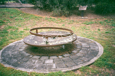 Eltham District Historical Society Inc
Slide - Photograph, Monument with time capsule, Eltham Community Centre, Main Road, Eltham, c.1997
The monument with time capsule was established by the Shire of Eltham Historical Society to commemorate Victoria’s 150th anniversary and mark the former location of the Eltham Town Centre, which existed along this section of Main Road, then known as Maria Street. The unveiling was conducted 10 November 1985 by Cr. Mary Grant (Shire President). The monument was constructed with a concrete base and the main feature is an old tyring plate or disc. The Time Capsule Ceremony involved lowering the sealed time capsule into place, bolting down its container lid and then concreting over the lid. The capsule contains items relating to present day (1985) Eltham and its people including a video film made by Joh Ebeli and also details of families and organizations who have contributed to construction of the monument. It is to be opened in the year 2035. The Society received an excellent response from local people, firms and organizations by way of assistance with this project. Graham Beyer, who originated the project, arranged many of the donations. He and his firm, Package Handling Equipment, donated the time capsule itself and carried out fabrication of sections of the monument. The design of the monument was adapted by Graham Beyer from drawings by Joh Ebeli. Charmac Industries donated the container for the time capsule and a cast gun metal name plate for the monument. BMG Concrete donated concrete for the base which was constructed by Caridi Construction Company. Northbourne Garden Supplies donated materials for the paving around the monument. Robert Becker from Eltham Apex directed construction of the paving by Society members. Terry Hutchinson donated the use of his crane to lift the tyring disc into place. Financial contributions were also made by the Eltham Chamber of Commerce and the Rotary Club of Eltham. In 1987 in commemoration of the Society’s 20th Anniversary, Joh Ebeli suggested the commissioning of a plaque to be added which explains the functions of the various items used in the Society’s Victorian 150th Anniversary Monument and this was unveiled by its designer, Joh Ebeli, on October 10, 1987.35mm colour positive transparency Mount - Black and Whiteeltham, eltham community centre, monument, public art, time capsule -
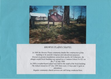 Rutherglen Historical Society
Image, c1985
Colour photograph of a small painted brick building with a story board in front of it. The photograph is mounted on a bright blue sheet of paper, along with a typed caption of the text from the story board.Caption text: "Browns Plains Chapel. In 1866 the Browns Plains community funded the construction of this building to be used for religious and educational purposes. Erected on granite foundations carted from nearby Mt Ochtertyre, the shingle roofed brick building was opened as a Common School No 821 on the 1st of July 1866. In 1880 a weatherboard school was built to the south of the brick building. The School closed on 31st Dec 1895 there were 12 boys and 12 girls in attendance. Regular community church services are still being conducted here."browns plains, churches, schools, common school no 821 -
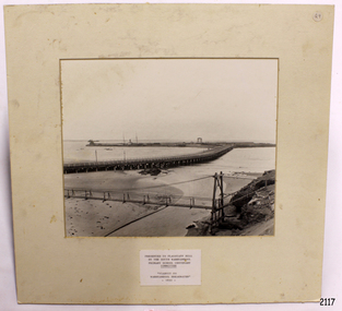 Flagstaff Hill Maritime Museum and Village
Photograph - Coastal Scene, Warrnambool South Primary School Centenary Committee, Viaduct to Warrnambool Breakwater - 1890, 1977
The local photograph shows the original footbridge across the Merri River near its mouth, the Viaduct road and the Warrnambool Breakwater with the Titan crane on it. The breakwater's construction was completed in 1890, the year this photograph was taken. The Viaduct has since been filled in to prevent water passing through the pylons, and the footbridge has been replaced. The photograph was presented to Flagstaff Hill on the centenary of South Warrnambool Primary School, 1877 to 1977, by the school's Warrnambool South Primary School Centenary Committee. The centenary was celebrated during August 12-13-14. The school was decommissioned in the 1990s.The photograph is locally significant for recording the completion of the Warrnambool Breakwater, for showing the original design of the Viaduct and for a clear view of the original footbridge across the Merri River. It also records the date of the presentation of the photograph celebrates the centenary of the 1877 to 1977 Warrnambool Sough Primary School.Photograph, black and white, mounted onto cardboard with a pasted-on label below the photograph. It shows the Merri River footbridge, the Viaduct, the Warrnambool Breakwater with the Titan crane, and the Port of Warrnambool. The label has an inscription. The photograph was taken in 1890 and was presented to Flagstaff Hill by the South Warrnambool Primary School's Centenary Committee ca. 1977. The photograph was taken in 1890 and was presented to Flagstaff Hill Maritime Museum by the South Warrnambool Primary School Centenary Committee in the Centenary year of the South Warrnambool Primary School;1977.Typed onto the label: "PRESENTED TO FLAGSTAFF HILL / BY THE SOUTH WARRNAMBOOL / PRIMARY SCHOOL CENTENARY / COMMITTEE / "VIADUCT TO / WARRNAMBOOL BREAKWATER" / - 1890 - "warrnambool, shipwreck coast, flagstaff hill, flagstaff hill maritime museum, flagstaff hill maritime village, warrnambool breakwater, viaduct, viaduct road, merri river bridge, merri footbridge, original merri foodtridge, titan crane, warrnambool south primary school, warrnambool south primary school centenary commitee, centenary committee, 1890, 1877, 1877-1977, lady bay, port of warrnambool -
 Kiewa Valley Historical Society
Map - Topographical, Ski Club of Victoria Bogong High Plains and Adjacent Peaks, Early 1930's
This map has been in the Ryder family for approx. 70 years. Probably used when bush walking and skiing in the early days on the Bogong High Plains. The Ryder family are farmers in the Kiewa Valley and were involved in taking their cattle up to the Bogong High Plains where they had a lease. The State Electricity Commission of Victoria constructed the Kiewa Hydro Electric Scheme opening up the area during the 1940's and 1950's. This type of map is an early one, used by people in the Kiewa Valley and possibly by surveyors prior to construction.The map is an early topographic map used by farmers living in the Kiewa Valley. It is historically significant as these people were involved in taking cattle up to the High Plains during summer and may have been used for bush walking and skiing.This is a sepia coloured paper map which was originally printed copyright registered. It was revised in 20/6.33/4.4.37/8.4.40/24.8.43/19/6/54. It shows roads / tracks / snow poles / snow pole numbers (27) / Snow pole spacing (3 chains. 66 yards) approximately 27 poles to the mile / height above sea level in feet - 5280. Water courses not definitely located etc.Rocky Valley Dam (Kiewa Hydro Electric Scheme) has been drawn on the map by hand with a biro. There is a wooden rod at the top of the map.topographic map; kiewa valley; ryder family; high plains of victoria -
 Federation University Historical Collection
Document - Document - Design, E J Barker: Ballarat College of Advanced Education: Final Year Project Report; "Internal Combustion Engine Driven Heat Pump", 1984
Mechanical Engineering Department Ballarat C.A.E. Final Year Report submitted by John Barker, 1984. The Report was "Internal Combustion Engine Driven Heat Pump". His supervisor was L E Taylor. The location of the experimental rig was in the Thermodynamics Laboratory at Ballarat Council of Advanced Education. This project involved the design, construction and limited testing of an Internal Combustion Engine Driven Heat Pump, utilising full waste heat recovery, for the purpose of heating mains supply water. John is the son of Jack Barker, foundation director of Ballarat College of Advanced Education.75 page report - typed with photos and diagrams. 38 pages - Appendix 1-8engineering, vice principal, foundation director, ballarat college of advanced education, bcae, mount helen campus, engineering drawing, design, manufacture, heat engines, internal combustion engine, report, supervisor, l e taylor, john barker, internal combustion engine driven heat pump, heat recovery, thermodynamics laboratory -
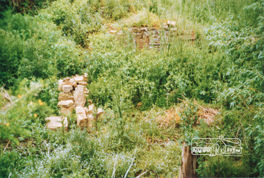 Eltham District Historical Society Inc
Photograph, Ruins of Coulstocks Mill, Janefield, South Morang
Mill Park Farm at Janefield on the Plenty River was established around 1840 by George Coulstock where he grew wheat. His flour mill was one of the first in Victoria, under construction as early as 1841. After bushfires and Coulstock's early death in 1842, the farm and its mill were taken over by local landowners Henry Miller and John Brock. Peter Hurlestone took charge of the mill. With water diverted from the Plenty River to fill the newly built Yan Yean Reservoir which opened in 1857, the Hurlestone family quit and that was the demise of the mill.Four colour photographs showing the ruins of Coulstocks Flour Mill (Janefield Mill), Janefield. 1. Stone wall 2. Old mill 3. Stone remains of old mill 4. Tree near old mill sitemills, flour mills, coulstock, janefield, plenty river, ruins, stone walls, plenty gorge, bundoora -
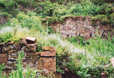 Eltham District Historical Society Inc
Photograph, Ruins of Coulstocks Mill, Janefield, South Morang
Mill Park Farm at Janefield on the Plenty River was established around 1840 by George Coulstock where he grew wheat. His flour mill was one of the first in Victoria, under construction as early as 1841. After bushfires and Coulstock's early death in 1842, the farm and its mill were taken over by local landowners Henry Miller and John Brock. Peter Hurlestone took charge of the mill. With water diverted from the Plenty River to fill the newly built Yan Yean Reservoir which opened in 1857, the Hurlestone family quit and that was the demise of the mill.Five colour photographs of ruins of Coulstocks Mill, Janefield (Mill Park - Bundoora)mills, flour mills, coulstock, janefield, plenty river, ruins, stone walls, bundoora, plenty gorge -
 Federation University Historical Collection
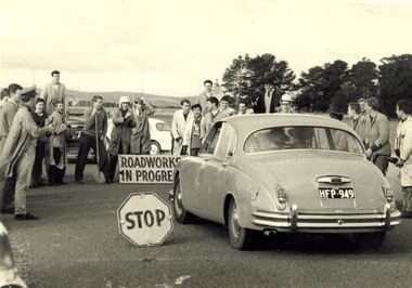
Photograph - Photograph - Black and White, Ballarat School of Mines Students at the R.A.A.F. Station, 1961, 1961
The RAAF retained the Ballarat airfield as its Radio School until 1961. The then-Shire of Ballarat negotiated with the Department of Interior to become the civil operator of the airfield and sought the maintenance on site of the hangars and other structures, however a majority of the P Huts were sold by the Commonwealth. (Wikipedia) Sir William Hudson was a New Zealand-born engineer who headed construction of the Snowy Mountains Scheme for hydroelectricity and irrigation in Australia from 1949 to 1967, when he reluctantly retired at 71. The scheme was completed in 1974, under budget and before time. (Wikipedia)A car with the registration plates HFP949 is stopped by a number of male students from the Ballarat School of Mines. It is a reception for Sir William Hudson at the RAAF station (Ballarat airport). Verso: R.A.A.F. Station 1961. See Magazine Reception for Sir William Hudson Visit. ballarat school of mines, raaf, ballarat airport, students, william hudson, sir william hudson, raaf bas, student activity -
 Federation University Historical Collection
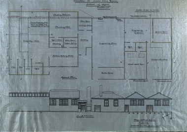
Plan - Plans, Ballarat School of Mines Plans for the Additions to Trades Class Rooms
Born in Ballarat, George William Clegg F.R.V.I.A. was articled to Tappin, Gilbert and Dennehy who had architectural offices in Melbourne, Sydney and Ballarat, from 1885-1889. Clegg formed a partnership with Gilbert who ran the Ballarat Office and later with Kell and Miller. This eventually became Clegg and Miller, then Clegg Miller and Morrow, and finally Clegg and Morrow (1916). From about 1907 up until his resignation in 1918 Clegg taught Architecture and Building Construction at the Ballarat School of Mines. From 1918 he pursues interests in the Eureka Terracotta and Tile Company.Two plans on linen, relating to additions in the trade classrooms at the Ballarat School of Mines.ballarat school of mines, george clegg, george william clegg, george w. clegg, clegg, miller and morrow, trades, architecture, buildings -
 City of Moorabbin Historical Society (Operating the Box Cottage Museum)
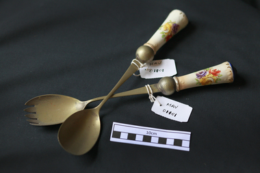
Kitchen Equipment, salad servers, c1900
Tthe key letters “EP”, represent “electroplated” or “electroplating”. The other letters often represent some other metal. For example the most common designation, EPNS, means “electroplated nickel silver”. All these designations indicate that the piece in question is made of silver plate. Electroplating involves placing an extremely thin layer of silver on the surface of the piece. The resulting silver content is very small. The remainder of the piece is made of some more common metal such as copper. The value of such pieces most often is not based on silver content. It’s based more on the design and construction of the piece. The Surridge family were early settlers in Moorabbin ShireA pair of silver plated salad servers with porcelain handlesE.P.N.S.early settlers, pioneers, market gardeners, moorabbin, brighton, bentleigh, cheltenham, cutlery, silver plated cutlery, porcelain, mrs surridge -
 Peterborough History Group
Plaque - Peterborough Golf Club Sponsor's Day Annual Golf Tournament
This event was held as a thankyou to the sponsors of the golf club. Peterborough Golf Club sponsors day annual golf tournament winners are 2004 Roberts Farm Supplies, 2005 Schomberg Inn, 2006 Camperdown Removals, 2007 KC Electrica,l 2008 KC Electrica,l 2009 Loader Construction, 2010 Plozza's Pirates, 2011 Hampden Veterinary Clinic, 2012 Timboon Premix, 2013 Green Con Australia P/L, 2014 Ryan golf, 2015 WFI, 2016 Sungold Milk, 2017 Boggy Creek Pub.Significant as it provides a snapshot of club sponsors over the years.Trophy with a central sculpture of a golfer and pylons on either side with the winners' name platesA plaque on the front engraved with Peterborough Golf Club "Sponsors Day" Annual Golf Tournament.peterborough, peterborough golf club, golf tournament, sporting honour boards -
 Robin Boyd Foundation
Document, Robin Boyd, Griffin's Melbourne, 1964
Boyd discusses the influence and legacy of the work of Walter Burley Griffin on Melbourne's architecture. Boyd discusses the utopian tendencies of Griffin as well as his temperament and approach to practice. The text goes on to discuss Griffin's exemplary works including the Capitol Building and Leonard House and the ongoing legacy of Griffin's work. Griffin's patented construction system, 'Knitlock', is also discussed with exemplary projects using this system mentioned. Griffin's influence is concluded as initially controversial and jarring to the conservative nature of Melbourne suburbia, but later becomes exemplary work and essential to the progression of Melbourne's architecture.Typewritten, photocopy, 15 pages, A4, 210x297.Signature. Pencil mark up on page 2, 3, 4, 6, 7, 9, 14.walter burley griffin, chicago school, melbourne, sydney, canberra, a.s. eggleston, edward billson, marion griffin, knitlock, capitol theatre, leonard house. -
 Melbourne Legacy
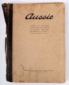
Book, Aussie, 1920
Aussie, a lighthearted account of life in the field for Australian troops during WW1. Featuring stories, cartoons, letters to the editor and much more. Aussie was conceived in November 1914 but it was not until January 18, 1918 that Aussie was first published with a print run of 10,000 copies. The third issue had a print run of 100,000 copies. A couple of single original issues are also in the archive. This was a compilation put together by Phillip Harris from the original editions and printed in Australia in 1920. Funds raised from the sale of the compilation went towards the construction of The Australian War Memorial.Despite the dreadful conditions on the Western Front during the war the Australian troops managed to procure enough rescoures to publish an interesting and humour packed account of life for them as it was. A great morale booster.Cover, cardboard, faded and some stains. Pages, paper, some tears, stains,discolouration.Front cover, "Aussie. A reprint of all the numbers of the Diggers' own paper of the battlefield, wholly written, illustrated and printed in the field by members of the AIF. Produced by the editor, Phillip L. Harris on behalf of the Australian War Museum. 1920. Forward by Major General C.B.B. White, K.C.M.G., C.B., D.S.O."world war one, souvenir, magazine -
 Otway Districts Historical Society
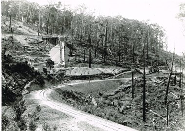
Photograph, Victorian Railways, Gellibrand ballast pit siding, c.1902
In 1902 a ballast siding was opened 4 km south of Gellibrand to provide materials for track construction. A spur siding with a capacity for six trucks was cut into the side of a slope. Above this was erected a loading bin and chute. The stone proved to be of durable quality so the siding continued after 1902 for periodic track re-ballasting works. The points were set for the main line and spiked shut when the siding was not in use. By the mid-1920s the Victorian Railways found it more economic to use ballast from Penshurst, so the siding was closed by 1925 and the rails lifted.B/W. Gellibrand ballast pit siding at 19 miles (30.6 km) south of Colac. gellibrand; gellibrand siding; railways; -
Moorabbin Air Museum
Machine - Curtiss P40E Kittyhawk A29-53 (41-13522), 1941
Historical Details: The Curtiss Kittyhawk P-40E A29-53, construction number 16738, was originally built for the USAAC as 41-13522 but delivered to the Royal Australian Air Force in March 1942 as part of Lend Lease aircraft diverted to Britain. A29-53 was shipped into Austral. Description: In all more than 800 examples of the Kittyhawk served with the RAAF, mainly in the South West Pacific Area, making it both numerically and operationally the most important type employed in the defence of Australia in World War 2. The Museum’s Kittyhawk. Level of Importance: Nationalc/n 16738 -
 Kew Historical Society Inc
Photograph - Construction of the electric tram line in Riversdale Road, Surrey Hills, E.J. Dower, 1916
Contextual or historic information One of a series of photographs, taken by Edgar James Dower in the second decade of the twentieth century. Born and raised in Olinda, his family later moved to Surrey Hills. He worked as an adult as a clerk in the city office of the Metropolitan Gas Company, and in his role as a 'collector', he was able to photograph scenes including the construction of tramlines and associated buildings in Kew, Hawthorn, Camberwell and Surrey Hills. Later he established a real estate agency with his brother - the E.J. Dower Real Estate Agency, Dandenong Office.The image is an historically significant record of the development of transport infrastructure which was used to connect Victorians in the first two decades of the twentieth century. This development resulted from increases in population and the consequent extension of Melbourne's suburbs. The photographs, both individually and collectively, richly detail the labour of workers and the tools and machinery used to create and extend Melbourne's tram network in the years preceding and during World War 1.Digital copy of an original oval mounted photograph depicting preparation for laying the tracks for the new electric tramline in Riversdale Road, Surrey Hills. Annotated verso: "Riversdale Road Surry Hills / preparing for electric tram line / Taken just west of Middlesex Road, looking west"theme --- travelling by tram, theme -- connecting victorians by transport and communications, trams -- boroondara (vic.), riversdale road -- surrey hills -
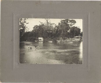
 Kew Historical Society Inc
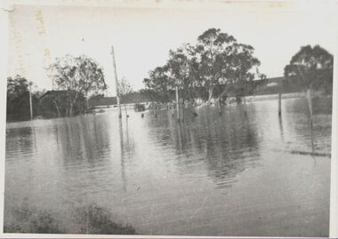
Photograph, Willsmere Bridge, 1934
Several boathouses were built in Kew and Fairfield in the late 19th and early 20th centuries. They included Chipperfield’s ‘Moorings’ and floating pontoon. The substantial two-storey house was named the Moorings, and incorporated an upper storey residence. The Moorings was almost washed away in the 1916 floods, and in 1934 almost totally submerged when the Yarra River rose 26 feet in 14 hours. Following the 1934 flood, the house was restored. The floating pontoon, sometimes referred to as a ‘kiosk’ or ‘canteen’, was used to store canoes. Both were removed in 1972 for the construction of the Eastern Freeway.This work forms part of the collection assembled by the historian Dorothy Rogers, that was donated to the Kew Historical Society by her son John Rogers in 2015. The manuscripts, photographs, maps, and documents were sourced by her from both family and local collections or produced as references for her print publications. Many were directly used by Rogers in writing ‘Lovely Old Homes of Kew’ (1961) and 'A History of Kew' (1973), or the numerous articles on local history that she produced for suburban newspapers. Most of the photographs in the collection include detailed annotations in her hand. The Rogers Collection provides a comprehensive insight into the working habits of a historian in the 1960s and 1970s. Together it forms the largest privately-donated collection within the archives of the Kew Historical Society.A view of flooded areas in North Kew in the flood of 1934.Willsmere Bridge. Chipperfields. 1934 floodwillsmere, flood, yarra flood, chipperfields, chipperfields boathouse, north kew -
 Kew Historical Society Inc
Photograph, Chipperfield's Boat House & Floating Pontoon, c.1939
Several boathouses were built in Kew and Fairfield in the late 19th and early 20th centuries. They included Chipperfield’s ‘Moorings’ and floating pontoon. The substantial two-storey house was named the Moorings, and incorporated an upper storey residence. The Moorings was almost washed away in the 1916 floods, and in 1934 almost totally submerged when the Yarra River rose 26 feet in 14 hours. Following the 1934 flood, the house was restored. The floating pontoon, sometimes referred to as a ‘kiosk’ or ‘canteen’, was used to store canoes. Both were removed in 1972 for the construction of the Eastern Freeway.This work forms part of the collection assembled by the historian Dorothy Rogers, that was donated to the Kew Historical Society by her son John Rogers in 2015. The manuscripts, photographs, maps, and documents were sourced by her from both family and local collections or produced as references for her print publications. Many were directly used by Rogers in writing ‘Lovely Old Homes of Kew’ (1961) and 'A History of Kew' (1973), or the numerous articles on local history that she produced for suburban newspapers. Most of the photographs in the collection include detailed annotations in her hand. The Rogers Collection provides a comprehensive insight into the working habits of a historian in the 1960s and 1970s. Together it forms the largest privately-donated collection within the archives of the Kew Historical Society.Chipperfield's Floating Canteen (also known as the pontoon) on the Yarra River. at North Kew The children wading in the river are believed to be the three sons of Dorothy Rogers."Chipperfield's Floating Canteen & house in background. At extreme right - observe channel where Connors Creek flows in."chipperfield's boat house, river yarra, dorothy rogers, floods 1916, 1934 -
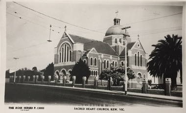 Kew Historical Society Inc
Print, Rose Stereograph Company, Sacred Heart Church, Kew, Vic, Twentieth Century
The history of the church goes back to 1872 when Jesuits purchased land in Walpole Street. By 1875 Archbishop Gould had laid a foundation stone on 14 February for a school. Early services for local Catholics were held in Richmond, Collingwood and later Hawthorn. By 1899 the land for the current church was purchased after a donation by Mr James Crotty of 3,000.00. The foundation stone was laid on 15 December 1918 by Archbishop Mannix. The dimensions of the church were to be 139 feet long by 77 feet wide with seating for 850 people. The cost of construction was 15,000.00. (Source: www.churchhistories.net.au )Sacred Heart Church, Kew, Vic., circa 1920-54. Photographic print of a Rose Stereograph Co. postcard in the State Library of Victoria collection.Inscription: The Rose Series P. 13053, Sacred Heart Church, Kew, Vic." Annotation in pencil: "KH-5. Foundation Stone laid 1918, completed 1921."churches -- kew (vic.), sacred heart church -- cotham road -- kew (vic.), catholic churches -- melbourne (vic.) -
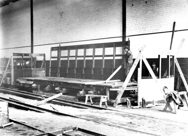 Ballarat Tramway Museum
Photograph - Geelong Tramways construction of Birney Safety Car
Stages in the construction of one of the two Birney Safety Cars, imported from the J G Brill Company of Philadelphia in kit form in 1924, and assembled in the area formerly occupied by the buses. In the background of Item 9237 is the trailer purchased from the North Melbourne Electric Tramway Company in 1924. Its number in the order in which Geelong cars were acquired was 13 (the Birneys were nos. 14 and 15) and it was eventually converted to a track scrubber car in 1926. It never carried the number 13 but was advertised for sale as such at the closure of the tramways in 1956. See Items 9232 and 9237.Black and white print on paper12-7 and GRS710/12/1/7 written on the back in pencil. No., 2 in a circle written on the back in ink.birney safety cars, j g brill company of philadelphia, track scrubber car, birney safety car construction -
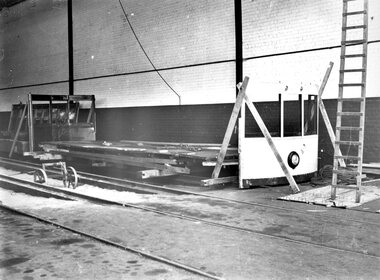 Ballarat Tramway Museum
Photograph - Birney Safety Car construction
Stages in the construction of one of the two Birney Safety Cars, imported from the J G Brill Company of Philadelphia in kit form in 1924, and assembled in the area formerly occupied by the buses. In the background of Item 9237 is the trailer purchased from the North Melbourne Electric Tramway Company in 1924. Its number in the order in which Geelong cars were acquired was 13 (the Birneys were nos. 14 and 15) and it was eventually converted to a track scrubber car in 1926. It never carried the number 13 but was advertised for sale as such at the closure of the tramways in 1956. See Items 9231 and 9237.Black and White print on paper.12-8 and GRS710/12/1/8 written on the reverse in pencil. No. 2 written on the reverse in ink.birney safety car construction, birney safety cars, j g brill company of philadelphia -
Melbourne Tram Museum
Document - Research Essay, Leigh J Harding, "Development of Tram Engine Houses", 1966
Research Essay, possibly the final draft, by Leigh J Harding looking at the engine houses that powered the Melbourne cable tram system from an Engineering and Architectural viewpoint. Has pencil notations to where photographs would be placed. Provides details on the background to their construction by the Melbourne Tramways Trust in the 1880s. Includes notes on the land acquisition, site plan, internal layout plan and notes on the operations and disposal. Notes on the Essendon, Bendigo and Ballarat power stations are included. The author was a Melbourne University Architecture student with this very detailed study part of his course.Yields information about the Melbourne cable tram engine houses and similar buildings.Report - 82 foolscap pages - typed and handmadetramways, tramcars, cable trams, engine house, winding houses, architects, power station -
 Old Gippstown
Building - Slab Kitchen
A slab construction cottage built in Ripplebrook in 1880 as a home for a single female landowner by the name of Ada Donaldson, and later relocated to Labertouche. It was donated to Old Gippstown by the Mason-Brook Pastoral Co. of Labertouche. A small building of horizontal timber slabs. It has a verandah over the front entrance and the front porch, a main living area with a cast iron stove in the fireplace and a separate room (probably a bedroom). There is a stone chimney on the back wall and the roof is shingled. Originally a cottage in its own right, the slab kitchen is now a part of the Bushy Park display.Medium local historic significance.A small building of horizontal timber slabs. It has a verandah over the front entrance and the front porch. There is a stone chimney on the back wall and the roof is shingled. This building was built in 1880sout kitchen, old gippstown, west gippsland, gippsland, gippsland heritage park, goldfields, coal mine, victorian era, moe, historical village, timber slab cottage, ripplebrook, labertouche, mason-brook pastoral co., baw baw shire, latrobe valley, old gippsland heritage park, gunaikurnai, latrobe city council -
Ballarat Tramway Museum
Article, John M Moore, "Geelong's Tramways", Sept. 1986
Article by John M Moore about the history of Geelong's Tramways, that appeared in the September 1986 issue of the Australian Railway Enthusiast. See also item 9810 for a similar article that appeared in the Geelong Historical Society journal, the Investigator. Includes a detailed article on the formation history of Geelong Trams by John M Moore including photos. Establishment of MESCo, J J Jobbins, construction, tracks, buses, practical jokes, map, trams and decorated cars. Includes names of many of the people involved with the Tramways, the SECV and Councils. Includes a diagrammatic map of the system.Yields information about the history of Geelong tramways and its operations.Five A4 pages copy of an article from the Australian Railway Enthusiasttramways, secv, geelong, tramcars, mesco -
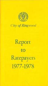 Ringwood and District Historical Society
Booklet, City of Ringwood Report to Ratepayers 1977-1978, 1977
Yellow covered community information booklet for Ringwood residents covering Council Representatives' and Service Organisations' contact details, Major Works, Planning (Ringwood Business Centre), Recreation, Litter, Rubbish Tip, Construction of Private Streets (Greenway/Dickasons Road Group), Health and Community Services, Municipal Elections, Rates, Dog Registrations, Overhanging Foliage, Building By-laws, Vandalism, House Numbering, Fire Hazards, Council Finances, and other points of general interest. and local services, sporting, and cultural facilities. Includes two City of Ringwood Free Tipping Vouchers valid until the end of 1978.Mayor's Message - Cr. Lawrie Lawrenson.rinx