Showing 11008 items matching " land"
-
 Parliament of Victoria
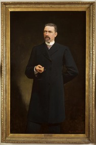
Portrait of Sir James Patterson, Coutts, Gordon 1865-1938, Premier James Patterson, 1893
Premier 23rd January 1893 – 27th September 1894. Born in Alnwick, England, Sir James Patterson (1833-1895) migrated to Victoria in 1852 to try his luck on the goldfields. After little success he turned his hand to farming, and later operated a slaughter yard at Chewton. Patterson served on the Chewton local council, being elected mayor four times before moving with his wife Anna and family to Melbourne in 1870. Patterson established a real estate business, and after two unsuccessful attempts to enter parliament in 1866 and 1868, he won the by election for Castlemaine in the Legislative Assembly in December 1870. He would hold this seat until his death 25 years later. Patterson served in Sir Graham Berry’s brief August to October 1875 government as Commissioner of Public Works and Vice-President of Board and Land Works. He repeated these roles two years later in Berry’s second government and additionally served as Postmaster-General, and in Berry’s third government was Commissioner of Railways and again Vice-President of the Board of Land and Works. In April 1889 after a time in Opposition, Patterson became Commissioner for Trade and Customs in Duncan Gillies’ Government. The following year he returned to the familiar positions of Public Works, Board of Land and Words and Postmaster-General. By 1891 Patterson was leader of the opposition, and when William Shiels’ government succumbed to a motion of no confidence, led by Patterson, he became premier on the 23rd of January 1893. During his premiership, James Patterson was also Chief Secretary and Minister for Railways. His term as premier coincided with a period of severe economic depression, and his enforced economies earned Patterson few public admirers. In May 1893 his government attempted to prevent a run on bank withdrawals and stabilise the sector, by declaring a 5 day 'bank holiday'. Patterson was awarded a knighthood in May 1894, however this did not increase public confidence in his government who were not returned to power in the August 1894 election. Again leader of the opposition, James Patterson died suddenly of influenza on the 30 of October 1895.This portrait was presented to Sir James Patterson by 'grateful citizens of Victoria' in appreciation of his services during the land boom depression. In 1929 the painting was donated to the Victorian Parliamentary Library by H. Lavinia Patterson, the wife of Sir James Patterson's nephew Colonel George Patterson.Oil on canvas, framed. Frame: ornate wood, gesso mouldings, unglazed. Signed on bottom right corner "G. Coutts" Stamped inscription along inner edge of canvas: "WINSOR AND NEWTON". Inscription on canvas, handwritten in ink: "13 1 92" from reverse.patterson, james brown (1833-1895) -
 Ringwood and District Historical Society
Document, List of bushland reserves in Maroondah - early 2000
Typed document"Attached to List" Hand written note from Helen Moss to Gayle Abbe ( Archivist Ringwood Historical Society) "Here is some information on Dexters Bush and a report I prepared on the bushland reserves in Maroondah which mentions many of the relevant Ringwood reserves. There is also a copy of my phone list for reserves contacts. Roger Lord is listed - so is Anne Kaufman who knows the Angus Avenue/Ruthven Way area very well and may be able to suggest some additions to your heritage list. It would also be worth talking to Eva about the Alexander's land, which is next to Dexter's, on the Dandenong Creek. Good luck, Helen Moss. -
 Ringwood and District Historical Society
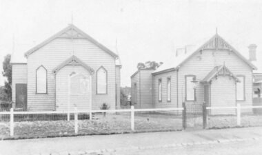
Photograph, Ringwood Methodist Church on site at Cnr. Melbourne St. and Whitehorse Rd 1904
Written on backing sheet, "Methodist Church on site at Cnr. Melbourne St. and Whitehorse Rd. On its removal to Greenwood Ave. Mr. J.B. McAlpin built shops on this site - land (Dimmey's) including his own estate agency." One photograph claimed church was moved to Greenwood Ave in 1916. Photograph taken in 1904. Another photograph states that the photograph is of the Methodist Church and Sunday School. Inserted in the sleeve of one of the photographs are two small postcard photographs that state they are, "Methodist Church in Main Street, Ringwood opposite railway station. See Mechanics Institute where Town Hall now stands - c1910. Photo by L. F. East". -
 Orbost & District Historical Society
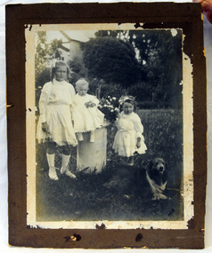
photograph, 1910 ?
George Nixon (1862-1941) selected land in Bete Bolong in the 1890's. He married Emily Warren in 1889 in Orbost. He was a shire councillor. He was a prominent breeder of Clydesdales and after a serious fall off a horse walked with a walking stick and special boot for the rest of his life. He was well-known for his interest in cars, horse-racing and politics. Mrs Nixon (Emily)was the first Red Cross president during WW1. They had ten children.both George and Emily are buried in the Orbost Cemetery. (ref:From White Knowle to Pumpkin Point by Hon Peter Nixon A.O.)George Nixon was the son of James and Alice Nixon. The Nixon families were among the earliest settlers on the Snowy River.A large black and white photograph which is glued on to a white paper frame and then on to brown cardboard. It is a photo of three children and a dog standing in a garden with a house in the background. The smallest child is sitting on a planter pedestal. The baby is Frederick Howard Nixon, the older girl is Essie Nixon.On back - George & Emily Nixon's family (Warren) Lexcine, Frederick, Esther In bottom RH corner - HDBphotograph family nixon-george -
 Warrnambool and District Historical Society Inc.
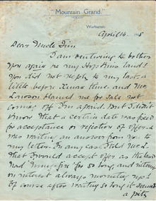
Document, Docket RF Kennedy, Letter written - 1908
This letter written by Mary Adams concerns the sale of a property, ‘my Hopkins land’, perhaps in the Warrnambool area. No information is available on Mary Adams or her ‘Uncle Jim’. There is a reference in the letter to ‘Mr Lawson’ and this may refer to a member of the Lawson family living in Warrnambool about this time, perhaps Richard Lawson who, in 1908, was Principal of a private school, Warrnambool College Academy. The Mountain Grand Guest House in Warburton was a well-known guest house in Victoria for many years and was still in existence in 1948. The letter came to the Society’s collection with other material relating to the Warrnambool Club. As no enlightening information is available on this letter or its contents it is of little importance at this time. Further research may render it a useful item to keep. This is a letter of two pages written in 1908 by Mary Adams to her Uncle Jim. The letter is handwritten in black ink. The letter is written on the green notepaper of the Mountain Grand Guest House Warburton, Victoria‘Mountain Grand, Warburton’ (on letterhead)mary adams -
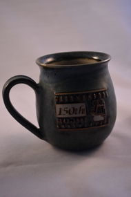 Warrnambool and District Historical Society Inc.
Household, Souvenir Cup (Warrnambool’s 150th ), 1997
This cup was produced by Ken Sadler as a souvenir of the 150th anniversary of the settlement of Warrnambool. Ken Sadler was a potter in Liebig Street, Warrnambool for many years (end of 20th century and beginning of 21st century). Warrnambool was founded as a planned town in 1847 to provide port facilities for the produce of squatters who had settled in the area. The town centre was surveyed by William Pickering at the request of Superintendent La Trobe of Melbourne and the first land sales were held in Melbourne in July 1847. The celebrations to mark the 150th anniversary of Warrnambool included concerts, race meetings, church services and the erection of an anniversary tablet on Cannon Hill. Ken Sadler, a well-known Warrnambool potter, made 500 of these cups which are now collectible souvenirs of the city’s 150th anniversary celebrations. This one retained by the Warrnambool and District Historical Society is numbered 189. The 150th anniversary of the founding of Warrnambool was an important event in the city’s history.This is a ceramic cup with a round base and larger rounded body with a round overhanging rim at the top opening. The cup is mottled green with an impressed image of a ship and lettering in white, gold and brown. There is some lettering on the bottom of the cup.‘Warrnambool 150th Anniversary 1847-1997’ ‘Sadler 97 189/500 Warrnambool’ warrnambool’s 150th anniversary, history of warrnambool, ken sadler, warrnambool potter -
 Eltham District Historical Society Inc
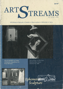
Journal, Peter Doughtery, ArtStreams: Vol. 10, No. 3, 2005
Vol. 10, No. 3, Jul-Aug 2005 CONTENTS Alan Marshall Short Story Award Winner 2 Ephemeral Sculpture 7 Food and a Question of Time - John Jenkins 10 Rhythm of the Land & Sea - Julie Tippene O'Toole 11 Silver Stars: A Mongolian Story - Lisa Edwards and Jenny Grinlington 12 Darebin La Trobe Art Prize 15 Jill Kahans mixes her media 17 Poetry 18 CD Reviews 19 Jack Henseleit - The Legend of Neil Douglas 20 Artin' About 21 Wining & Dining 26 Listings 28"Peter Dougherty has been involved in the local art scene for many years. As publisher and editor of the arts magazine Artstreams, his comments on the various branches of the arts are widely respected. His "The Arts" column in the Diamond Valley Leader presents a brief summary for a much wider cross section of the local community. Peter also operates his own gallery and the Artstreams Cafe at the St Andrews market. Peter has a wealth of knowledge about present day and historical aspects of local art and artists." - Eltham District Historical Society Newsletter No. 161, March 2005Colour front and back cover with feature articles and literary pieces with photographs and advertisements printed in black and white. 28 pages, 30 cm. Vol. 1, no. 1 (Nov. 1996) - Vol. 10, no. 5 (summer ed. 2005/06) art streams, art streams magazine, ephemeral sculptures, alan marshall short story award, click here to add keywords, darebin la trobe art prize, ephemeral sculpture, jack henseleit, jenny grinlington, jill kahans, john jenkins, julie tippene o'toole, lisa edwards, neil douglas, rhythm of the land & sea -
 Eltham District Historical Society Inc
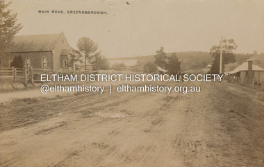
Postcard - Photograph postcard, Main Road, Greensborough, c.1910
View looking northeast along Main Street. The Greensborough Methodist Church stood at the present-day entrance to Greensborough Plaza shopping centre at 25 Main Street, Greensborough. It was opened in 1873. The Main Street Church served the congregation well, but by the 1960s it was decided to sell the old building and invest in a new home. The land at 37 Grimshaw Street for the current Uniting church was purchased in 1962 from the estate of Mrs White. Construction commenced on 31 July 1965 and the new church was opened on February 5, 1966. (https://www.churchhistories.net.au/church-catalog/greensborough-vic-uniting)Digital file only Postcards scanned from the collection of Michael Aitken on loan to EDHS, 2 Sep. 2022michael aitken collection, postcards, greensborough, main street, methodist church -
Glen Eira Historical Society
Article - Trinity Congregational Church, Glen Huntly
Handwritten undated notes (refer History of Primitive Methodism in Victoria and Tasmania – Rev. M Clarke). Article includes style of church building, history of building and interior decoration. Also includes history of some monetary donations, purchasing of land and church opening , small handdrawn map showing where church was before removal to current site. Reprinted articles from The Victorian Independant dated January 1910 and November 1909 on the opening of the Glen Huntly venture and the Revs who participated, and then the beginning of some committees, & Fellowship groups. Also mentions the appointment of Ivan Stebbins for six months.trinity congregational church, glen huntly, tennis, grange road, mercy g.g., bevan dr., primitive methodist church, dovan a. p. rev., holley j. j. rev., eastern road., freeman w, jones j. w. rev., south melbourne, griffith a. j. rev., devenish a. s. rev., lord. t, gosman dr, jones alfred., bryant. s, stebbins ivan, orr mr., billinghurst mr, copper mr, tregaskis mr., davidson mr., congregational hall, halls, wharington mrs., pavell g., rosstown, holden mr., bishop mr., sunday schools, white a. f., cockfield mr., orr mrs., billinghurst mrs., davidson mrs., o’ donnell miss, watkins miss., billinghurst miss., davidson miss., griffith mr., newing mr. -
 Glen Eira Historical Society
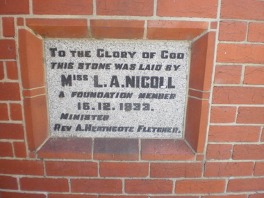
Article - St. Andrew’s Presbyterian Church, North Road, Gardenvale East
Handwritten document giving brief details on wording on foundation stone of St. Andrew’s church, undated and author unknown. Photocopy of pamphlet produced for the stewardship campaign 1957 for St. Andrew’s Presbyterian Church Gardenvale East, with several photos. It includes history as well as current situation at 1957. Photocopied notes and photo of the Army Hut used by Gardenvale Primary School in 1921 only as donated by church for and year then Reverted back to church use. Photocopy of letter to Glen Eira News and City Council re-proposed subdivision of church land from Robert W. Sinclair.st. andrew’s presbyterian church, foundation stones, nicoll l.a., heathcote-fletcher a. rev., north road, seach street, smith a. f.h. rev., mcneilage alex rev., gardenvale east, caulfield south, younger street, gardenvale east church, nicholls rev., rowlands w. rev., lang walter, sunday schools, yeaman f.e. rev., brown f.e., brick, towers, manse, choirs, groups, smith mrs., curtis e.e., morse roger, marryatt harry, pegler adrian, savill t., south caulfield, gardenvale primary school, sinclair robert w., dakin ms., campbell felicity -
 Eltham District Historical Society Inc
Slide - Photograph, Woodhaven Estate off Reynolds Road, Eltham, c.May 1988
The Age, Saturday, April 15, 1989, Page 72 OPEN SAT SUN 2-4 WOODHAVEN ESTATE A sample of house and land packages for your consideration: 3 br Ige rumpus $159,950 4 br tri level $169.9S0 4 br split level $169,500 Colonial with verandahs $199,950 Big 4 br dble garage $235,000 Huge exec 5 br S266.000 Meet our representative on site 2-4pm Sat and Sun in Booth Court, Eltham. off Reynolds Rd. Melway ref 22.E.335mm colour positive transparency (1 of 23) Mount - Kodak EktachromeProcess Date MAY 88Mmain road, eltham, housing estate, nicholas lauder real estate, woodhaven estate -
 Eltham District Historical Society Inc
Slide - Photograph, Incident Control Centre, Kangaroo Ground, Ness Lane and Kangaroo Ground-St Andrews Road, c.May 1988
The Age, Saturday, April 15, 1989, Page 72 OPEN SAT SUN 2-4 WOODHAVEN ESTATE A sample of house and land packages for your consideration: 3 br Ige rumpus $159,950 4 br tri level $169.9S0 4 br split level $169,500 Colonial with verandahs $199,950 Big 4 br dble garage $235,000 Huge exec 5 br S266.000 Meet our representative on site 2-4pm Sat and Sun in Booth Court, Eltham. off Reynolds Rd. Melway ref 22.E.335mm colour positive transparency (1 of 23) Mount - Kodak EktachromeProcess Date MAY 88Mincident control centre, kangaroo ground, kangaroo ground-st andrews road, ness lane -
 Seaworks Maritime Museum
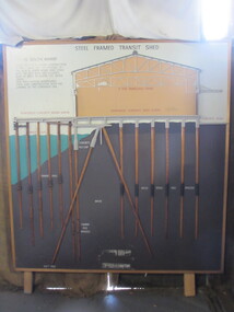
Diagram
Cross section of wharves and steel framed sheds built along the Yarra river between the 1920s and 1960s. The South Melbourne side of the Yarra River is reclaimed swamp land. Without a solid foundation for the construction of the wharves and transit sheds, extended piles were sunk into the mud to support the wharf and shed structures. An example of this design may be found at 5 South Wharf which was built in the 1930s. The transit sheds gave shelter for cargo while waiting to be loaded onto a ship or to be collected by truck after being unloaded from a ship. The transit shed became surplus to requirements with the introduction of containers.Wooden diagram of a transit shed featuring a shed sitting atop mud with some water. It shows the splices sitting in the mud to support the shed. "Steel Frames Transit Shed/ 15 South Wharf/ Model of Typical wharf construction/ of 1940- made for the opening of/ the "new" 15 South wharf shed (1944),/ Note the deep piles and elevated/ rear of the shed to allow for the truck/ trays./ This shed feature disappeared/ from port construction with the/ coming of the container era/ reinforced wharf apron/ 3 ton travelling crane/ reinforced concrete shed floor/ concrete road/ water level/ concrete pile cap/ cradled piles/ timber pile splices/ mud/ mild steel pile splices/ 110 ft pile" "On loan from Port of Melbourne Authority" -
 Greensborough Historical Society
Certificate of Title, Supreme Court of Victoria (Probate Division) et al, Certificate of Title Vol. 2567 Fol. 294, Vol. 3134 Fol. 605, 22/05/1895
Title Vol. 2567 Fol. 294 in the name of The Greensborough Estate Company Limited, 164 acres four and a half perches, being part of Crown Portion 17 Parish of Keelbundora, County of Bourke. Dated 22nd May 1895. Northern boundary Greensborough Road (now Grimshaw Street), Southern boundary Nell Street, Eastern boundary Plenty River, Western boundary road (now named McDowell Street); Title Vol. 3134 Fol. 605 in the name of Adolphe Frederic Seelenmeyer, land as described above, LP 4759 and transfers and other instruments to 9 March 1948Folder containing two Certificates of Title (3p. + 9 p.) and twenty pages of miscellaneous documents, including historical summary, brief biography of A. F. Seelenmeyer, two Death Certificates and photocopied extracts from probate documents, as listed in table of contents, ed. by Peter Simmenauergreensborough, greensborough estate company limited, grimshaw street greensborough, plenty river, nell street greensborough, mcdowell street greensborough, adolphe frederic seeley, formerly seelenmeyer, adolfe frederic seelenmeyer -
 Orbost & District Historical Society
letter, September 1 1909
When early settlers began to arrive on the Snowy River somewhere in the 1880s, the land was mostly swamps and heavily timbered jungle on the river frontages. The swamps were drained bit by bit using hand tools. The frontages were cleared by axe and shovel and fire. Several kinds of crops were experimented with such as hops, hemp and maize. Maize grew particularly well and became the main crop of the district. (info. from October 2006 ODHS Newsletter) The Argus was a morning daily newspaper in Melbourne, Australia that was established in 1846 and closed in 1957. It was considered to be the general Australian newspaper of record for this period.Maize-growing has been an important agricultural industry in the Orbost district since early settlement. This item is associated with that history.A typed letter sent to a local maize farmer requesting information on maize growing. The letter has the "Argus" letter head. The name of the recipient is unknown.maize agriculture-orbost correspondence-argus -
 Orbost & District Historical Society
black and white photograph, 1937
In 1912 the school at Pumpkin Point opened to serve the children of farmers living in the Bete Bolong district. This meant a big change in their way of life because in the past the children had been rowed across the Snowy River each day to attend school at Jarrahmond. Myrtle Bunting was the first HT of the school which had been erected on a block of land purchased from H. Richardson. The school functioned until 1952 when a shortage of pupils caused its closure. As a bus service to Orbost now operated, the school at Pumpkin Point faced permanent closure. J. McKeown bought the building.This item is associated with the history of education in the Orbost districtA small black / white photograph of students from the Bete Bolong State School at the District Sports.on back - S.S. Bete Bolongeducation-orbost bete-bolong-state-school -
 Marysville & District Historical Society
Photograph (Item) - Black and white photograph, Unknown
A digital copy of a black and white photograph of the Buxton Hotel in Buxton. The Buxton Hotel was built by William Burchall, probably in the late 1870s. The first owner, who also had land locally, was Frederick Nichols (1833-1904). The Buxton Hotel is located directly opposite the General Store. It was fronted with two huge oak trees and bordered and backed by large pine trees. It was a weatherboard structure with a painted corrugated iron roof. Old split wood shingles were covered by corrugated iron, which overlaid the shingles to make the roof watertight. The wooden shingles date back to the 1850s.A digital copy of a black and white photograph of the Buxton Hotel in Buxton.buxton, victoria, australia, buxton hotel, photograph, william burchall, frederick nichols -
 Marysville & District Historical Society
Photograph (Item) - Black and white photograph, Mark James Daniel, 1904
A digital copy of a black and white photograph of Nichol's Buxton Hotel in Buxton. The Nichol's Buxton Hotel was built by William Burchall, probably in the late 1870s. The first owner, who also had land locally, was Frederick Nichols (1833-1904). The Buxton Hotel is located directly opposite the General Store. It was fronted with two huge oak trees and bordered and backed by large pine trees. It was a weatherboard structure with a painted corrugated iron roof. Old split wood shingles were covered by corrugated iron, which overlaid the shingles to make the roof watertight. The wooden shingles date back to the 1850s.A digital copy of a black and white photograph of Nichol's Buxton Hotel in Buxton.buxton, victoria, australia, buxton hotel, nichol's buxton hotel, photograph, william burchall, frederick nichols -
 Federation University Historical Collection
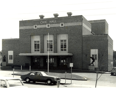
Photograph - Photograph - Black and White, Ballarat Civic Hall, c1965
The City of Ballarat unanimously resolved to erect a Civic Hall in 1951. The architects, Gordon Murphy, of Melbourne, and H.L. and L.J. Colburn, of Ballarat, were commissioned in 1952. The Council constructed the foundations and footings for the building under the supervision of the former City engineer, Mr L.H. Finch, in 1953. These footings are of massed concrete. The design for the building took advantage of the cross fall of the land, providing for the Small Hall to be entered from the Doveton Street frontage through a foyer under the Main Stage, the structure is steel with brick panels, with accommodation for 1,592 persons in the Main Hall and 440 persons in the Lower Hall. Black and white photograph of a brick building known as Ballarat Civic Hall. It is located on the corner of Mair Street and Doveton Street North. The Shakespeare statue out the front of the building was unveiled on 17 November 1960. ballarat civic hall, civic hall, colburn, finch -
 City of Moorabbin Historical Society (Operating the Box Cottage Museum)
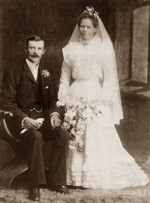
Photograph, B&W, George William Box & Elizabeth Honor Tippett Wedding 1902, c1902
Box Cottage Museum, a reconstruction of an early settler hut, is named after the Box family who resided there 1865 -1913 . George William Box 1870 -1933 was a son, and twin brother of Cecilia Eliza, of William and Elizabeth Avis Box who lived in Box Cottage and farmed the land 1865 - 1913 . George William Box married Elizabeth Honor Tippett 1902 and they had 8 children. Elizabeth Avis Box gave them a shop with a dwelling in Jasper Road where Elizabeth Honor sold groceries and vegetables while George obtained various jobs. Box Cottage Museum, a reconstruction of an early settler hut, is named after the Box family who resided there 1865 -1913 . George Box was the father of William Box who with his wife Elizabeth Avis Box and 13 children lived and farmed on the block of land in Jasper Road, East Brighton ( now McKinnon / Ormond) that was part of the Henry Dendy Special Survey 1841 Inscribed inside Album : “ The early photos in this album were found by Mr (Laurie) Lewis when he was demolishing the Old Box Cottage. He gave them to Mrs Avis Box Eldridge who in turn gave them to me. They were not identified. I believe they rightly belong in the Cottage. I have attempted to identify them and present them in a way they can be preserved as a historical record of the era.” A B Leigh A black & white Wedding photograph 1902 of George William Box 1870-1933 and Elizabeth Honor Tippet Box d1953TALMA 119 Swanston Street / Melbourne / and at Sydneybox george, box mary, box william, box elizabeth, box alonzo, box mary louisa, dendy henry, were j b, dendy's special survey 1841, brighton, moorabbin, bentleigh, mckinnon, ormond, market gardeners, dairy farms, early settlers, pioneers, jasper road, gurr jabez, gurr eliza, pay henry, pay anna, ward willam, box henry, ward elizabeth emma, box john, sheldrake martha, rushall eleanor, box caroline, box william, box elizabeth avis -
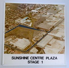 Sunshine and District Historical Society Incorporated
Photograph (1982) - Part Sunshine Business Area, Sunshine Centre Plaza Stage 1, 1982
The Sunshine business area has undergone major change from industrial manufacturing to retail. This aerial photograph shows the industrial areas that existed on both sides of Hampshire Road in 1982, and which have since been replaced by two shopping centres and the library building. The photograph also shows the old swimming pool, and retail outlets that no longer exist such as Waltons, Clark Rubber, Fosseys and the original Safeway store. It also shows a vacant land where the current Centrelink office now exists. The photograph was originally used as a promotion for the Sunshine Centre Plaza retail complex.This photograph is a historical record of what part of Sunshine looked like 3 decades ago.Large cardboard mounted sepia photograph with thin white plastic edging. Grey painted outline shows the site in 1982 on which the SUNSHINE CENTRE PLAZA was to be built, as well the buildings that then existed in part of the business area of Sunshine.Sunshine Centre Plaza Stage 1aerial view, 1982, sunshine centre plaza, sunshine business area, massey ferguson buildings, old sunshine pool. waltons -
 Whitehorse Historical Society Inc.
Photograph, Mitcham Primary School No 2904
On 24th September 1888 a wooden state school opened on land purchased on the north west corner of Whitehorse and Mitcham Roads. In 1890 a contract was let for the construction of a one-room brick school house on that site. By 1907 student numbers had risen to 120 so the Church of Christ Hall was leased for 10/- a week. By 1922 cracks had appeared, plaster had fallen in the school and both the Brittania Street Scout Hall and the Methodist Church has been leased for classrooms. On 10/4/1930, a new school, to be occupied by the upper grades was opened in its present location.Coloured picture of Mitcham Primary School No 2904 The traffic lights are at the intersection of Mitcham and Doncaster East Roads - 2012mitcham primary school no. 2904, schools -
Hume City Civic Collection
Photograph, Lois Alexander, Goonawarra Winery, 1986
It is a photograph of Goonawarra Winery that was first established by James Goodall Francis, who in 1863 applied to lease 26 acres of land on the condition that he plant vines on some of it. The property continued to be worked as a vineyard by him and his son, Wilfred, until the late 1920s when wool and mutton were production were preferred to wine production and the vines were pulled out. The Carmody family purchased purchased the property in 1961 and used it for grazing until 1976, when they replanted vines there. In the early 1980s, John and Elizabeth Barnier purchased the property and continued to run the property as a vineyard.Goonawarra is one of the earliest vineyards and wineries to be established in Sunbury. A non-digital coloured photograph of a large winery building.goonawarra vineyard, john barnier, elizabeth barnier, james goodall francis, sunbury road, vineyards., winery -
 Ballarat and District Irish Association
Photograph - Colour, Clare Gervasoni, Crossley near 'Hillside" McCartney's Lane, 2014, 04/04/2014
Before 1941 "Hillside", McCartney's Road was associated with the Carroll Family. Patrick Edmund Carroll, his wife Mary Matilda Fitzgerald, and children Kathleen, Ronald and Rosemary were the last members of the family to live at and work "Hillside". Stanislaus Kelly and his wife Margaret (nee Gorman) bought the farm from the Carroll family. The couple raised six children on the land: May, Mary, Leo, Ray (Lofty), Daniel (Tich) and Bernadette. The family grew spuds and onions on the hill and milked cows, with the little dairy located on the eastern side of the house. (information from Mary Kelly)Colour digital photographs of Crossley, Victoria, near McCartney's Lane. The house depicted is "Hillside" in McCartney's Lane. The views towards an extinct volcano is Tower Hill.crossley, hillside, carroll, tower hill, mccartney's lane -
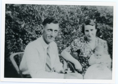 Mt Dandenong & District Historical Society Inc.
Photograph
The Wenborn family acquired Ferguson's Lot 19 of the Village Settlement where the original Mount Dandenong School was opened in a shed. WH Collom owned the land after Ferguson and then it passes to the Wenborns. This photograph shows Jim Wenborn with his wife Ivy and daughter Mary. The Wenborns had another daughter, Joan. Both children attended Mt Dandenong State School. John Lundy-Clarke grew up in the Kalorama/Mt Dandenong area and later in life (1972-74) began to write a comprehensive history of the area working from an original settlement map in an effort to cover all areas.Black and white photograph showing a man and woman seated in a garden. The woman is holding a small baby. Handwritten inscription on reverse by John Lundy-ClarkeJim Wenborn and family.wenborn, jim wenborn, ivy wenborn, mary wenborn, joan wenborn, ferguson, wh collom, mt dandenong school -
 Mt Dandenong & District Historical Society Inc.
Photograph, Site of Jeannie Richardson's Home 1973
John Lundy-Clarke grew up in the Kalorama/Mt Dandenong area and later in life (1972-74) began to write a comprehensive history of the area working from an original settlement map in an effort to cover all areas. It was in the clearing on the left that John William (Willie) Richardson built a home for his wife Jeanie Green. It was called Mount Calvin. Jeanie was often ill and the family left the area seeking a warmer climate. They eventually settled in Brisbane. Willie sold the home and 60 acres around it to W. Rowse. Jeanie died in 1916. The remainder of the land was sold by solicitors to cover debts. Black and white photograph showing a treed hillside with a cleared area to the left hand side. Handwritten inscription on reverse by John Lundy-ClarkeLooking towards the site of Jeannie's home from near Doughty’s Road Nov 1973. Her house was in the centre of the clearing on the left. Photo Jan 1974 JLC.mount calvin, jeannie richardson, jeanie green, john william richardson, willie richardson, jeanie richardson, rowse -
 Ballarat Tramway Museum
Map, Electric Supply Co. of Vic (ESCo), Ballarat Electoral Map - ESCo, 1900
Document prepared by the Electric Supply Co of Victoria, as part of an order under the Electric Light and Power Act 1896, section 5 of order No. 17 granted to company. Dated 19/2/1901 and signed by the Postmaster-General. Shows the order area being parts of the City of Ballaarat, Sebastopol and Ballarat East. Shows the street names, boundaries, principal power line routes, land reserves, parks, mine locations, railways and Lake Wendouree. Signed by R L Williams Town Clerk City of Ballarat, J R Hall for the Borough of Sebastopol, and John Gent for the Town of Ballarat EastYields information about the power supply to the Ballarat area.Cloth backed paper map, coloured and marked up as exhibit 17.Notes in ink including the signature of Benjamin Deakin 24/9/00 and certified by the three involved municipal Town Clerks.ballarat power supply, esco, electric supply co of victoria, city of ballaarat, east ballarat, sebastopol, orders, power lines, power supply -
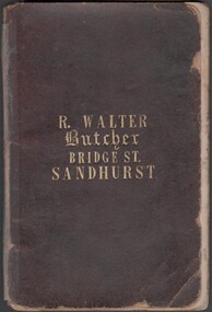 Bendigo Historical Society Inc.
Book - 1859 Almanac
Richard Walter, butcher, operated a butchery in Bridge St., Bendigo. The shop was part of the Australian Hotel. It was operating in 1857 when Walter advertised for a sausage maker. In 1863 the business was sold to Ceber and Robertson. At this time he sold five lots including, land at California Gully, 32 acres at Ellesmere, the Australia Hotel including a coopers, chemist and stables all leased to reliable tenants. In 1865 he was granted 50 square miles south of Charleville, near Murweh on the Warrego River. It was here that he died 24/8/1869 when he accidentally fell into the river and drowned.Small notebook (initial pages have been removed) with 1859 Almanac on internal covers. Ledger style notebook with gold lettering on cover "R. Walter, Butcher, Bridge Stret, Sandhurst"butcher, bridge stret, sandhurst", walter -
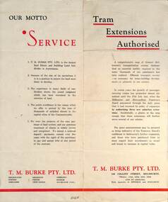 Ballarat Tramway Museum
Pamphlet - Real Estate, T M Burke Pty Ltd, "Tram Extensions Authorised", 1936
Wal Jack collected tramway and railway items for his collection. This pamphlet gives details of the Melbourne Public Transport system - rail, tram and bus in late 1936. Issued by T M Burke Pty Ltd of 840 Collins St Melbourne, Real Estate agents, shows the extensive sub-divisions where land was available for purchase and notes the MMTB authorisation of new tram routes. Gives details of the T M Burke services. Routes shown as authorised (16-7-1936) are: Keilor Road Essendon, High St North Balwyn and Hawthorn Road East Brighton. Demonstrates a Real Estate Sales pamphlet.Pamphlet - four colours printed on cream coloured bond paper, folded vertically originally.letter, wal jack, buninyong, railway lines -
 Kew Historical Society Inc
Photograph - Cosy Five Roomed Rough Cast Bungalow, Kew, J E Barnes, c.1920
Subdivision plans are historically important documents used as evidence of the growth of suburbs in Australia. They frequently provide information about when the land was sold on which a built structure was subsequently constructed as well as evidence relating to surveyors and real estate and financial agents. The numerous subdivision plans in the Kew Historical Society's collection represent working documents, ranging from the initial sketches made in planning a subdivision to printed plans on which auctioneers or agents listed the prices for which individual lots were sold. In a number of cases, the reverse of a subdivision plan in the collection includes a photograph of a house that was also for sale by the agent. These photographs provide significant heritage information relating house design and decoration, fencing and household gardens. The photograph is also aesthetically significant as it was taken by J. E. Barnes, a nationally significant photographer. He was the most important photographer to have worked in Kew. He was active as a photographer in the district from c.1906 until his death in 1921. Best known as 'the Embarkation Photographer' (see the Australian War Memorial collection), Josiah Earl Barnes was also the official photographer employed by the Borough (and later Town, then City) of Kew. He clearly also completed commercial jobs for local businesses, as is the case in this photograph of a house for a local real estate and financial agent. A modest weatherboard house with rough-cast rendered walls. The gabled entrance incorporates elements of the Japanese aesthetic. The strong lines of the dark timber gable are reinforced by the colour and shape of the pickets in the fence. In contrast to an earlier period, the chimneys appear truncated. The use of extensive double-hung sash windows in the front rooms reflects a new interest in light in houses. The use of separate sunshades over windows in an earlier period is here replaced by an extension of the roofline over the window. The photographer Josiah Barnes died in 1921; so, the photograph of the house must predate this date. The location of the house, which was advertised for sale, has to date not been identified. Illegible inscription. Photographer's information on mount.josiah earl barnes, j e barnes, photography - kew, interwar housing - victoria, 1920s housing - kew