Showing 1534 items
matching aerial photographs
-
 Glen Eira Historical Society
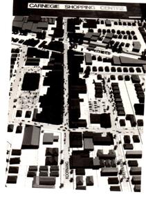
Article - Koornang Road, Carnegie
... an undated original black and white aerial photograph (84mm x 64mm... an undated original black and white aerial photograph (84mm x 64mm ...File contains 2 items about Carnegie shopping centre in Koornang Road. 1/A one page article from The Age newspaper, dated 05/11/2011, about Carnegie and its shopping centre along Koornang Road. The article provides a brief description of the area, house prices and includes a colour photograph of the Koornang Road Carnegie shopping strip. 2/The file also includes an undated original black and white aerial photograph (84mm x 64mm) of the Carnegie Shopping Centre. Source unknown.carnegie, koornang road, packer park, lord reserve, shepparson avenue, suburbs, shopping centres -
 Port Melbourne Historical & Preservation Society
Photograph - Aerial view of J Kitchen and Sons site, Ingles Street, Port Melbourne, early 1930s, 1930s
... Large Black and White aerial photograph on brown cardboard... Large Black and White aerial photograph on brown cardboard ...Large Black and White aerial photograph on brown cardboard showing Kitchen and Sons buildings including the 1925 Administrative Building No 34 on Ingles st.Photograph taken looking North Easterly with Swanston and Barret Pty concrete works; Port Melbourne Football ground in foreground; Yarra River in top left hand corner; showing South Melbourne and Royal Botanic Gardens in the distance. Taken in the early 1930sindustry - manufacturing, built environment - industrial, j kitchen & sons pty ltd -
 Hume City Civic Collection
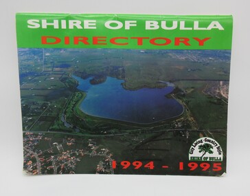
Directory, Shire of Bulla Directory, 1994 - 1995
... A 20 page booklet with an aerial photograph... A 20 page booklet with an aerial photograph of the Greenvale ...The Directory was published by the former Shire of Bulla in 1994 - 1995 and was issued to residentsa living withing the Shire. It features details of public services which were available within the area at the time as well as maps of the settlements and some private advewrtisements.A 20 page booklet with an aerial photograph of the Greenvale Dam and surrounding area on the front cover. A green strip is along the spine of the booklet with the words 'Shire of Bulla' printed in white and 'Directory' printed in red. '1994 - 1995' is printed in red across the bottom of the front cover and the Shire of Bulla - 'City Living . Country Style' logo is in the bottom RH corner. The back cover features an advertisement for the Roxburgh housing development.shire of bulla, directory, sunbury, bulla, attwood hill, craigieburn, george evans collection -
 Bayside Gallery - Bayside City Council Art & Heritage Collection
Photograph, W.H. Hansom, Sandringham, 1921
... Photograph. Black and white aerial photograph... hotel Photograph. Black and white aerial photograph ...sandringham, aerial, coast, bathing box, w.h. hansom, victoria, suburbs, photograph, airspy, beach street, bay road, abbott street, sandringham hotel -
City of Kingston
Photograph - Black and white, 5 January 1984
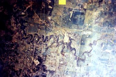
... Aerial photograph of Cheltenham, Heatherton, Mentone... image] 5,300' ASL VIC DLS© 5-1-84 Aerial photograph ...Cheltenham and Heatherton are suburbs in the City of Kingston that were originally established as a rural market gardening community. The market gardens, farms and paddocks have gradually been sub-divided into housing and industrial estates and associated infrastructure such as schools and shopping facilities. This aerial image covers a diverse section of the City of Kingston, taking in the suburbs of Cheltenham, Heatherton, Mentone and Parkdale. By 1984, the market gardens of the district have been replaced by housing and factories. The Nylex factory is visible and now closed. Mentone Bowl on the corner of Warrigal Road and Nepean Highway has now been replaced by high rise apartments, another feature of the changing landscape in the City of Kingston. The vacant land now occupied by the Moorabbin Airport Direct factory Outlet (DFO) is also depicted.Aerial photograph of Cheltenham, Heatherton, Mentone and Parkdale within the City of Kingston. The area depicted in the 1984 aerial view includes Centre Dandenong Road and Cheltenham East Primary School (top left), Kingston Heath Reserve (top right), intersection of Lower Dandenong Road, Warrigal Road, Balcombe Road and Nepean Highway (bottom left), Balmoral Drive/McSwain Street Parkdale (bottom right).White text: 3831-179 Lens information [indecipherable] RINGWOOD M/S 7922-3 RUN 16 [Clockface image] 5,300' ASL VIC DLS© 5-1-84cheltenham, heatherton, mentone, parkdale, market gardens, urbanisation -
Glenelg Shire Council Cultural Collection
Photograph - Photograph - View of port and facilities, c. 1974
... Aerial colour photograph, taken from the south. Grain...: (no inscriptions) Back: (no inscriptions) Aerial colour photograph, taken ...Port of Portland Authority archives.Front: (no inscriptions) Back: (no inscriptions)port of portland archives -
Port Melbourne Historical & Preservation Society
Photograph - Aerial view of Port Melbourne, 1993
... Two large colour aerial view photographs of Port Melbourne... to seamen Two large colour aerial view photographs of Port Melbourne ...Two large colour aerial view photographs of Port Melbourne piers and surrounds: .01 - View from land .02 - View from the bay Abel Tasman is at Station Pierpiers and wharves - station pier, piers and wharves - princes pier, piers and wharves - webb dock, built environment - domestic, transport - shipping, abel tasman, port melbourne primary school, missions to seamen -
 Ringwood and District Historical Society
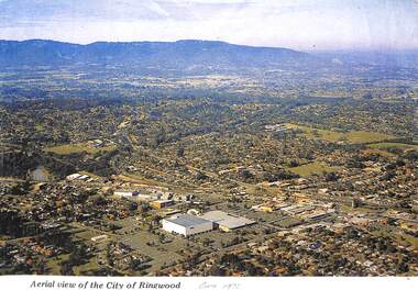
Photograph, Aerial view of the City of Ringwood - Circa 1972
... "Written on face of photograph" Aerial view of the City...), Ringwood High and Technical Schools. Coloured photograph Aerial ...Coloured photograph"Written on face of photograph" Aerial view of the City of Ringwood showing Eastland (stage 1), Ringwood High and Technical Schools. -
Glenelg Shire Council Cultural Collection
Photograph - Photograph - Aerial view of Thomas Borthwick and Sons abattoir, c. 1968
... Photograph - Aerial view of Thomas Borthwick and Sons...Black and white photograph. Aerial view of Thomas Borthwick... UP TO 1000 PERSONNEL Black and white photograph. Aerial view ...Port of Portland Authority archives.Front: (no inscriptions) Back: T.B + S PORTLAND ABBATOIR/ PORTLAND'S MAJOR INDUSTRY EMPLOYS UP TO 1000 PERSONNELport of portland archives, thomas borthwick and sons abattoir, drive-in theatre -
 University of Melbourne, Burnley Campus Archives
Photograph - Black and white prints, Aerial View of Burnley Campus, 1963-1970
... Black and white photographs. Aerial View of Burnley Campus.... Black and white photographs. Aerial View of Burnley Campus. (B ...Freeway was not begun until 1968.Black and white photographs. Aerial View of Burnley Campus. (B) Original of (A). Enlargement (C) Laminated copy(A) Inscribed on reverse, "South Eastern Freeway 9.7.63 R22.024.439." (C) Paper attachment: The Burnley College Portion of Richmond Park in 1972. Swan Street Takes Its Familiar Route. The Boulevard Has Been Constructed. The Golf Course is in Place. The Series of Parallel Buildings Along the Railway Line at the Bottom of the Photo Are the Poultry Sheds Used For Egg-Laying Competitions. Burnley Sidings Were Still to be Built. In the Mid-1990's Much of the Western Portion of the College Grounds/Richmond Park Was Sold.burnley campus, aerial view, south eastern freeway, richmond park, swan street, yarra boulevard, richmond golf course, poultry sheds -
 University of Melbourne, Burnley Campus Archives
Photograph - Black and white print, Aerial View of Burnley Campus, 1972
... Black and white photograph. Aerial View of Burnley Campus... Boulevard Richmond melbourne burnley campus aerial view freeway ...Black and white photograph. Aerial View of Burnley Campus. Enlargement of B92.553C. Aerial view of Burnley Campus.Inscribed on reverse, "30.1.72 2602/62."burnley campus, aerial view, freeway -
 University of Melbourne, Burnley Campus Archives
Photograph - Black and white print, Airspy, Aerial View of Burnley Campus c. 1925, c. 1925
... Colour photograph of black and white photograph. Aerial... photograph of black and white photograph. Aerial view of Burnley ...TH Kneen and EB Littlejohn note that the Principal's House has been extended. This was done for J P McLennan, Principal 1917-1921. Note "Bird Cage" in Orchard, dwarf fruit trees, shed where tobacco was stored. Photo taken before Plant Research Institute was built in 1929. Photo shows there had been cultivation outside the College grounds, beyond the orchard area and hedge.Colour photograph of black and white photograph. Aerial view of Burnley Campus. Cultivation outside Burnley Campus burnley campus, principal's house, jp mclennan, bird cage, orchard, dwarf fruit trees, plant research institute, principal's residence, tobacco storage sheds, cultivation outside campus -
 Bendigo Historical Society Inc.
Map - CAMPBELL COLLECTION: BENDIGO AND DISTRICT MAPS
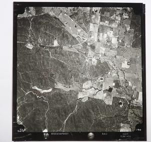
... Map. Two aerial photographs of Kangaroo Flat and Lockwood...MAP Bendigo agricultural lands Map. Two aerial photographs ...Map. Two aerial photographs of Kangaroo Flat and Lockwood (part). Crusoe Reservoir bottom right corner on Crusoe Road, shows Merindah Road running between Lockwood and Crusoe Roads. Map Name : Bendigo Mapsheet Run 2. 14-2-71, 13,200 A.S.L.. Map shown with NORTH at bottom of page, VIC 2479 at corner. Map 2 continues to the west. A joined copy of both photographs is also included.map, bendigo, agricultural lands -
 Greensborough Historical Society
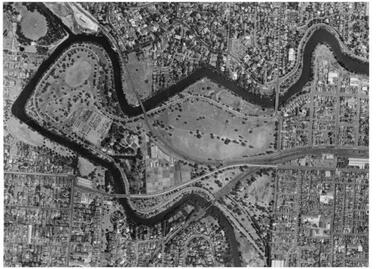
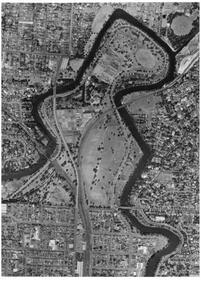
Slide - Photograph, John Ramsdale, Aerial view of Plenty River: Slide 16, 1990s
... aerial photograph...Photograph shows aerial view of the Plenty River.... Plenty Lower Plenty melbourne Photograph shows aerial view ...Photograph shows aerial view of the Plenty River.Part of the John Ramsdale collection of slides and audio visual material.Colour photograph scanned from slide.No maker's marks. No caption on slide.plenty river, aerial photograph -
 Sunshine and District Historical Society Incorporated
Photograph (1982) - Part Sunshine Business Area, Sunshine Centre Plaza Stage 1, 1982
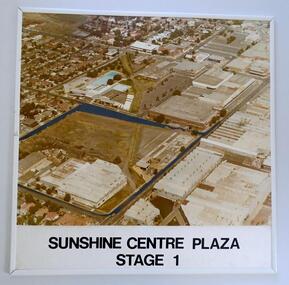
... industrial manufacturing to retail. This aerial photograph shows... to retail. This aerial photograph shows the industrial areas ...The Sunshine business area has undergone major change from industrial manufacturing to retail. This aerial photograph shows the industrial areas that existed on both sides of Hampshire Road in 1982, and which have since been replaced by two shopping centres and the library building. The photograph also shows the old swimming pool, and retail outlets that no longer exist such as Waltons, Clark Rubber, Fosseys and the original Safeway store. It also shows a vacant land where the current Centrelink office now exists. The photograph was originally used as a promotion for the Sunshine Centre Plaza retail complex.This photograph is a historical record of what part of Sunshine looked like 3 decades ago.Large cardboard mounted sepia photograph with thin white plastic edging. Grey painted outline shows the site in 1982 on which the SUNSHINE CENTRE PLAZA was to be built, as well the buildings that then existed in part of the business area of Sunshine.Sunshine Centre Plaza Stage 1aerial view, 1982, sunshine centre plaza, sunshine business area, massey ferguson buildings, old sunshine pool. waltons -
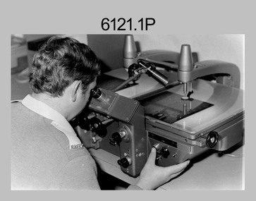
 Bendigo Military Museum
Photograph - Aerotriangulation Production – Army Survey Regiment, Fortuna, Bendigo, c1970s to 1980s
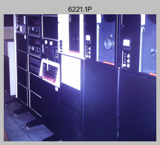
... , tie, and survey control points on aerial photographs. Wild..., tie, and survey control points on aerial photographs. Wild ...This collection of 14 photos was most likely taken in the 1970s and 1980s in Air Survey Squadron. The PDP 11/70 minicomputer shown in photo .1P was the operating system introduced in 1977 as the mainframe system for the control of the APC4, aerial triangulation block adjustments, SORA OP Analytical Orthophoto control, APR Analytical Terrain Profile Recorder computation, graphics, and general computing. Technicians used the Wild A9 Stereocomparator shown in photo .2P to accurately measure between pass, tie, and survey control points on aerial photographs. The Zeiss D2 Planimat Stereoplotter shown in photos .3P to .4P was used for analytical orthophoto control. It was introduced in 1972-1973 The Zeiss (Jena) Stecometer analytic stereocomparator for air photography shown in photos .5P to .11P and .14P was introduced at Air Survey Squadron in 1963. Aerotriangulation production was expedited using computers for analytical photogrammetric processes. The technician accurately measured between pass, tie, and survey control points on aerial photographs. Wild PUG4 point transfer devices shown in photos .12P to .13P were introduced in c1968 superseding the PUG2 devices. PUG4 devices were used by technicians to stereoscopically view the photography containing the survey control points and the mapping aerial photography. The Control points were transferred from the control photography to the mapping diapositives of aerial photography by drilling their locations into the photographic emulsion.This is a set of 14 photographs of Air Survey Squadron personnel operating aerotriangulation equipment at the Army Survey Regiment at Fortuna, Bendigo, c1970s to 1980s. Photographs .1P to .13P were on 35mm colour slide film and scanned at 96 dpi. Photograph.14P was printed on photographic paper and was scanned at 300 dpi. They are part of the Army Survey Regiment’s Collection. .1) - Photo, colour, c1979, PDP-11 minicomputer. .2) - Photo, colour, c1970s, Unidentified technician operating a Wild A9 Stereocomparator. .3) - Photo, colour, c1970s, Zeiss D2 Planimat Stereoplotter. .4) - Photo, colour, c1970s, Zeiss D2 Planimat Stereoplotter, unidentified technicians. .5) - Photo, colour, c1970s, Zeiss D2 Planimat Stereoplotter, SGT Christopher Wardley. .6) - Photo, colour, c1970s, Zeiss D2 Planimat Stereoplotter. .7) to.9) - Photo, colour, c1970, Zeiss (Jena) Stecometer, unidentified technicians. .10) to.11) - Photo, colour, c1988, SPR Toni Wright operating a Zeiss (Jena) Stecometer. .12) - Photo, colour, c1970s, Wild PUG4 point transfer device, SPR John Shepard. .13) - Photo, colour, c1970s, Wild PUG4 point transfer device, SPR David Edwards. .13) - Photo, colour, c1970s, Wild PUG4 point transfer device, SPR David Edwards. .14) - Photo, colour, c1980, Zeiss (Jena) Stecometer, SGT Bruce Hammond.Some of the equipment is annotated on the frame of the 35mm slides.royal australian survey corps, rasvy, army survey regiment, army svy regt, fortuna, asr, aerotrig, photogrammetry -
 Federation University Historical Collection
Photograph - Black and White, Aerial View of the Ballarat School of Mines
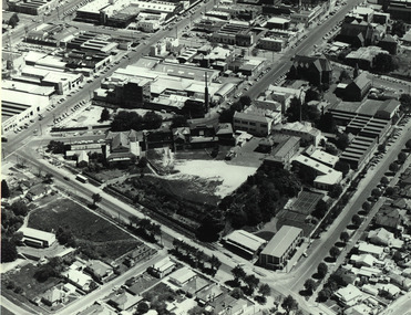
... Aerial photograph of the Ballarat School of Mines soon... grant street hickman street flecknoe Aerial photograph ...Aerial photograph of the Ballarat School of Mines soon after the Ballarat Gaol was demolished. The photograph shows the Corbould Building, tennis court, Model Mine, Ballarat Junior Technical School, Administration Building, former Wesleyan Church, Former Court House, Former Ballarat Gaol walls, Old Plumbing Building, Old Chemistry Building, Botanical Gardens, Corbould Hall, Ballarat Brewery, Ballarat Girls' School, Albert Street, Grant Street, Hickman Streetcorbould building, ballarat school of mines tennis court, model mine, ballarat junior technical school, administration building, former wesleyan church, former court house, former ballarat gaol walls, old plumbing building, old chemistry building, botanical gardens, corbould hall, ballarat brewery, ballarat girls' school, albert street, grant street, hickman street, flecknoe -
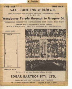 Ballarat Tramway Museum
Newspaper, The Courier Ballarat, This Day Auction Notice, 17/06/1972 12:00:00 AM
... is to be sold at 10.30am. Agent - Edgar Bartrop. Features an aerial... is to be sold at 10.30am. Agent - Edgar Bartrop. Features an aerial ...Newspaper clipping from The Courier, Ballarat, dated Saturday, 17 June 1972 real estate advertisement, This Day Auction Notice, advising that the former SEC depot in Wendouree Parade is to be sold at 10.30am. Agent - Edgar Bartrop. Features an aerial photograph with the site and streets marked on it, along with the dimensions of the land to be sold. One of a large group of newspaper cuttings from John Bainbridge, 7/4/02. See Reg Item 2770 for Bartrop's handout.depot, buildings, auctions, bartrop -
City of Kingston
Photograph - Colour, 31 January 1993
... Laminated colour aerial photograph of the Carrum... Laminated colour aerial photograph of the Carrum and Patterson Lakes ...Patterson Lakes is a suburb in the City of Kingston that is built one kilometre upstream of the mouth of the Patterson River. The area is bordered by the Patterson River and Eel Race Drain which enters the Kananook Creek. The suburb consists predominantly of newer housing developments and the tidal canal system of the development joins Port Phillip Bay. Patterson Lakes and the Kananook Creek were previously part of the extensive Carrum Carrum Swamp. The area was once a source of fish and eels for the Mayone-Bulluk clan of the Bunurong people. Over time the area was drained and in 1973 investigations commenced into the development of a unique residential area that would be built adjacent to canals and waterways. It was originally proposed to be known as "Gladesville". The development would give the suburb's homeowners access to Port Phillip Bay "from their back door". Circa 1974, the area was rezoned from rural to residential and named Patterson Lakes. Development has been continuous since the 1970s with construction of residential housing, schools, shopping centres, marinas, a hotel and library.Laminated colour aerial photograph of the Carrum and Patterson Lakes region within City of Kingston. This 1993 image includes Patterson River Secondary College, Roy Dore Reserve, Kananook Creek and Nepean Highway. The railway line can be seen as it veers inland from Eel Race Road, Seaford. The section of Ocean Reef Drive and Palm Beach Drive in Patterson Lakes appears to be a recent development with many spare blocks and new houses under construction.Black typed lettering on white adhesive label: 31.1.93 Black typed lettering on white adhesive label: 27E/7140 31/1/93 12.55 pm Black typed lettering on white label: 7140 Yellow round adhesive label located on left sidepatterson lakes, seaford, kananook creek, carrum carrum swamp, canals and waterways -
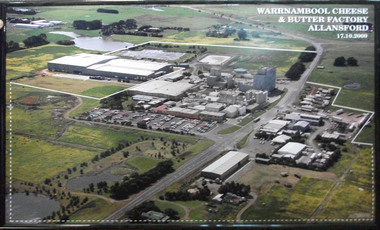 Cheese World Museum
Photograph, Warrnambool Cheese and Butter Factory Co Ltd site 2000 -aerial view, 2000
... Aerial colour photograph of Warrnambool Cheese and Butter... 17.10.2000 Aerial colour photograph of Warrnambool Cheese and Butter ...Warrnambool Cheese and Butter Factory Company was formed by a group of Warrnambool business men. The company was registered in May 1888 and commenced commercial production in November 1888. The company retained its independence for more than 125 years until acquired by Canadian firm Saputo. It has operated from the same site since its inception and also has an office in Japan. Milk processing is undertaken by Sungold. Milk powder for export is also produced on-site. Cheese World is a retail arm of the company operates on a connected site selling company products, local food products, wine and cheese tasting. Cheese World Museum operates under the Cheese World umbrella.Aerial colour photograph of Warrnambool Cheese and Butter Factory in wooden frame. Shows buildings and surrounds. Lines indicate factory boundaries, dotted lines indicate property extension. Date is recorded on the image.17.10.2000allansford, warrnambool cheese and butter factory company, saputo, dairyiing, dairy manufacturing, diary manufacturers, cheese, butter -
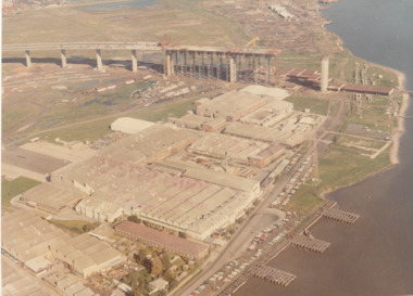 Port Melbourne Historical & Preservation Society
Photograph - Aerial view of West Gate Bridge under construction, 1960 - 1979
... Colour aerial (faded) photograph of West Gate Bridge under... stamped on photo. and on rear Colour aerial (faded) photograph ...Colour aerial (faded) photograph of West Gate Bridge under construction with two land spans incomplete. "Rotten Row" (disused old piers) in the foreground. Aircraft factory and other industry in foreground."Master Copy . Not to be removed from Marketing department " lightly stamped on photo. and on reartransport, engineering, engineering - bridges, fishermans bend, industry, west gate bridge, rotten row, williamstown, yarra river -
Glenelg Shire Council Cultural Collection
Photograph - Photograph - Aerial view of Thomas Borthwick and Sons abattoir and Walock Swamp, Nov-55
... Photograph - Aerial view of Thomas Borthwick and Sons...Black and white photograph. Aerial view of taken from... Victoria Australia Black and white photograph. Aerial view of taken ...Port of Portland Authority archives.Front: (no inscriptions) Back: 'AIRSPY PHOTO' CD PRATT 86 McCracken St ref No2/B/73 Essendon Phone Fx 2840 Victoria Australiaport of portland archives, tb and s abattoir, walock swamp -
Glenelg Shire Council Cultural Collection
Photograph - Photograph - View of port and facilities, c. 1974
... Black and white photograph. Aerial view taken from...: (no inscriptions) Black and white photograph. Aerial view taken from ...Port of Portland Authority archives.Front: (no inscriptions) Back: (no inscriptions)port of portland archives, portland harbour, k s anderson, no6, no5 berths -
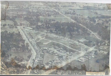 Bendigo Historical Society Inc.
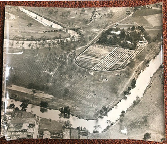
Photograph - Aerial View Sydenham Gardens Estate Circa 1972
... Photograph: aerial view of Sydenham Gardens Estate Circa... Photograph: aerial view of Sydenham Gardens Estate Circa 1972 ...The Sydenham gardens were set up in 1854 to provide an area of relaxation for diggers. A German, Mr Kraemer, made extensive plantings of ornamentals and fruit trees. The area expanded to 11 acres in 1865 and 25 acres in 1916. T O Hunter owned the gardens from about 1896 and initially it was used for many types of entertainment including, picnics, festivals and sporting events. It was situated off Holdsworth Road in what is now Jackass Flat. T O Hunter was a cordial manufacturer in Macrae Street, who was prominent in many sporting areas. He was President of the Bendigo Coursing Association and raced both dogs and horses. By the time he sold the gardens in 1936 to Mr Muir, he was using the gardens as grazing for his horses.Photograph: aerial view of Sydenham Gardens Estate Circa 1972 , as noted on photo Colour photo, A5 sizephoto sydenham gardens estate, aerial photo -
 Port Fairy Historical Society Museum and Archives
Photograph
... Black and white photograph aerial view of Braim House... house Black and white photograph aerial view of Braim House ...Views from St Johns 1973Black and white photograph aerial view of Braim House Methodist Church and it's Manse with Sunday school in backgroundphoto, st johns, tower, james street, aerial, methodist, weslyian, braim house -
 Bendigo Military Museum
photograph - Aerotriangulation Production – Army Survey Regiment, Fortuna, Bendigo, c1980
... , tie, and survey control points on aerial photographs...., tie, and survey control points on aerial photographs. Royal ...This collection of five photos was most likely taken in 1980. Wild PUG4 point transfer devices were used by technicians in Air Survey Squadron to stereoscopically view the photography containing the survey control points and the mapping aerial photography. The Control points were transferred from the control photography to the mapping diapositives of aerial photography by drilling their locations into the photographic emulsion. The Zeiss (Jena) Stecometer analytic stereocomparator for air photography was introduced at Air Survey Squadron in 1963. Aerotriangulation production was expedited using computers for analytical photogrammetric processes. The technician accurately measured between pass, tie, and survey control points on aerial photographs.Air Survey Squadron Aerotriangulation Section - Army Survey Regiment, Bendigo. c1980. This is a set of five photographs of Air Survey Squadron personnel operating aerotriangulation equipment at the Army Survey Regiment at Fortuna, Bendigo, c1980. Photographs .1P to .4P are on 35mm negative film and were scanned at 96 dpi. Black and white photo .5P is on photographic paper and was scanned at 300 dpi. They are part of the Army Survey Regiment’s Collection. .1) - Photo, black & white, c1980, Wild PUG4 point transfer device, unidentified technician. .2) - Photo, black & white, c1980, Wild PUG4 point transfer device, unidentified technician. .3) - Photo, black & white, c1980, Wild PUG4 point transfer device, unidentified technician. .4) - Photo, black & white, c1980, Zeiss (Jena) Stecometer, unidentified technician. .5) - Photo, black & white, c1980, Zeiss (Jena) Stecometer..1P to .5P No personnel are identified.royal australian survey corps, rasvy, army survey regiment, army svy regt, fortuna, asr, air survey, aerotrig -
 Ringwood and District Historical Society
Map - State Aerial Survey, Dandenong Ranges Area Sheet 7, Parishes of Warrandyte, Scoresby, Ringwood and Nunawading - 1956
... , July 1956, from aerial photographs and Cadastral Survey... aerial photographs and Cadastral Survey information. Subsequent ...Map of central and southern areas of Ringwood and part of Ringwood East and Heathmont compiled by Dept of Lands and Survey, July 1956, from aerial photographs and Cadastral Survey information. Subsequent coloured hand-drawn additions showing layout of a number of post-NSW Separation era proposed subdivisions that did not eventuate, including Village of Studley Estate, Township of East Kew Estate, Township of Ballyduffy Estate, Township of New Flemington Estate, Township of East Hawthorne Estate. Ringwood A4B2, 849 A4B Zone 7. Scale: 10 chains to 1 inch. Contour interval 20 feet. -
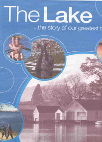 Ballarat Tramway Museum
Book, The Courier Ballarat, "The Lake ... the story of our greatest treasure", 6/11/2003 12:00:00 AM
... companies. The centre pages has an aerial photograph of the lake... by local companies. The centre pages has an aerial photograph ...Fifty six page Newspaper supplement, titled "The Lake ... the story of our greatest treasure", published by The Courier, Ballarat, 6 November 2003. Features the history, precincts, life, flora and fauna of the Lake Wendouree and Botanical Gardens. Includes many articles, photographs of the lake, Olympic games rowing in 1956, Ballarat Tramway Museum (p31) with a photo of inside the depot, a timeline and many advertisements by local companies. The centre pages has an aerial photograph of the lake with features numbered, including the depot.trams, tramways, lake wendouree, botanical gardens, olympics, btm -
City of Kingston
Photograph - Black and white, 5 January 1984
... Aerial photograph of Cheltenham, Beaumaris, Moorabbin... Aerial photograph of Cheltenham, Beaumaris, Moorabbin and Highett ...Moorabbin, Cheltenham and Highett are suburbs in the City of Kingston with a diverse mix of development and zoning. The market gardens, farms and paddocks have gradually been sub-divided into housing and industrial estates and associated infrastructure such as schools and shopping facilities. The area includes many parks, reserves and golf courses.This aerial image covers a diverse section of the City of Kingston, taking in the suburbs of Cheltenham, Moorabbin, Beaumaris and Highett. By 1984, the market gardens of the district have been replaced by housing and factories. The Gas and Fuel state-of-the-art Scientific Services Department is visible on Nepean Highway Highett. The CSIRO Highett site can also be seen. Both sites have now been demolished and have undergone remediation. The Southland site is visible and yet to be redeveloped by Westfield. This image portrays the diversity of development in the City of Kingston with a mixture of green spaces, housing and commercial and industrial features.Aerial photograph of Cheltenham, Beaumaris, Moorabbin and Highett within the City of Kingston. The area depicted in the 1984 aerial view includes Eden Street and Edward Street, Cheltenham (top left), Weatherall Road and Reserve Road, Cheltenham/Beaumaris (top right), Turner Road and Chesterville Road, Moorabbin (bottom left), Nepean Highway (left section), Graham Road and Middleton Street, Highett (bottom right). A large section of this image includes Cheltenham Park and Victoria Golf Club.White text: 3831-219 Lens information [indecipherable] RINGWOOD M/S 7922-3 RUN 15 Clockface image 5,300' ASL VIC DLS© 5-1-84cheltenham, highett, industrialisation, urbanisation, moorabbin, beaumaris -
 St Kilda Historical Society
Photograph, 11 Eildon Road, St Kilda, 1990-2000?
... oringinal colour photograph, TV aerial, cars parked in road... aerial, cars parked in road 11 Eildon Road colour photograph ...oringinal colour photograph, TV aerial, cars parked in roadcolour photograph, unmounted good condition11 Eildon Road