Showing 4334 items
matching railway road
-
 Melbourne Tram Museum
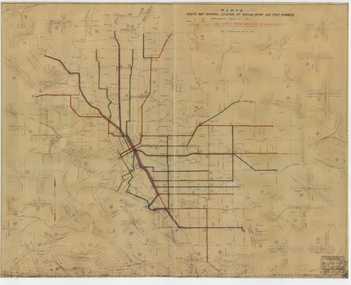
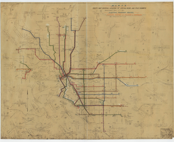
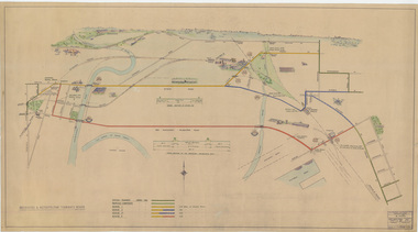
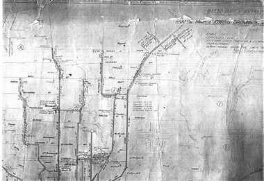
Drawing, Melbourne & Metropolitan Tramways Board (MMTB), "Route Map showing location of special work and pole numbers" "All night tram routes in colours", late 1941
... cabins roads, railways, and stations. Originally signed... crossovers, track layouts at junctions, signal cabins roads, railways ...Map of the system shown at two inches = 1 mile. Drawing No. P5799. Shows crossovers, track layouts at junctions, signal cabins roads, railways, and stations. Originally signed by Perway Engineer - 20/12/1940, though originally drawn in 1922. Has been marked up in colour pencil to show the all-night routes and the individual services. The plan shows the lines to Maribyrnong Munitions works along Cordite Ave and Wests Road and the track from Moonee Ponds to Union Road, opened in July 1941, but not the extension to Essendon Airport built in 1942.Demonstrates a detail drawing of Melbourne tramways, junctions and pole numbers.Drawings - dyeline cloth-backed print - titled - "Route Map showing the location of special work and pole numbers" and subtitled - "All night tram routes in colours". trams, tramways, mmtb, trackwork, tramways, junction, map, world war 2, night trams -
 Melbourne Tram Museum
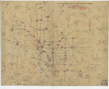
Drawing, Melbourne & Metropolitan Tramways Board (MMTB), "Route Map showing location of special work and pole numbers" "substations", late 1942
... cabins roads, railways, and stations. Originally signed... crossovers, track layouts at junctions, signal cabins roads, railways ...Map of the system shown at two inches = 1 mile. Drawing No. P5799. Shows crossovers, track layouts at junctions, signal cabins roads, railways, and stations. Originally signed by Perway Engineer - 20/12/1940, though originally drawn in 1922. The plan shows the lines to Maribyrnong Munitions works along Cordite Ave and Wests Road and the track from Moonee Ponds to Union Road, opened in July 1941, and the extension to Essendon Airport built in 1942, but not the Queen St North Essendon substation. Shows underground cables, tram and bus depot, workshop locations, and substation locations and their priority.Yields information about the MMTB substation locations in 1942.Drawing - dyeline cloth backed print - titled - "Route Map showing location of special work and pole numbers" and subtitled - "Substations". trams, tramways, mmtb, trackwork, tramways, junction, map, world war 2, substation -
 Melbourne Tram Museum
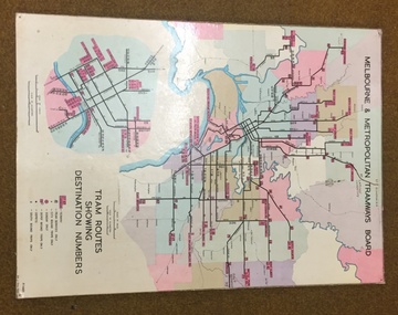
Map, Melbourne & Metropolitan Tramways Board, Del J. Chau, "Tram Routes showing destination numbers", 1972
... working, names of main destinations, roads, railway stations... of main destinations, roads, railway stations and rail lines ...Titled "Tram Routes showing destination numbers". Map dated 1972, showing routes with route numbers, including short working, names of main destinations, roads, railway stations and rail lines, municipalities, rivers, scales, city section in detail, depots and Sunday only services. In bottom right hand corner has number P.14431, Del J. Chau 1972. The original has been altered to show the Bundoora, La Trobe University and East Burwood lines and the change to Airport West. Type of map that was placed on the rear of the driver's doors of a W Class tramcar.Demonstrates a MMTB produced map used in trramcars.Full colour map or poster printed on heavy cardboard.trams, tramways, mmtb, map, routes -
 Whitehorse Historical Society Inc.
Clothing - Cotton Striped Dress, c1930s
... ). Catherine was the gate-keeper at the Tunstall (Nunawading) railway... (Nunawading) railway gates at Springvale Road during 1934-1952 ...Dress owned by Catherine Ann Windsor (Kitty) (born 23 Nov 1919 died 17 Nov 2002) in the 1930s/1940s. She was grandmother of Rachael Cottle, Whitehorse Historical Society Secretary (2011-2016). Catherine was the gate-keeper at the Tunstall (Nunawading) railway gates at Springvale Road during 1934-1952. A house was supplied for the gatekeeper. The gates were closed to traffic from midnight to 5 am.Dress with elastic shirring top and frilled neckline with puff sleeves. Rayon material. Coloured orange, green, grey and white.tunstall (nunawading) railway station, windsor, catherine ann (kitty), cottle, rachael, dress, victorian railways -
 Orbost & District Historical Society
black and white photograph, first half 20th century
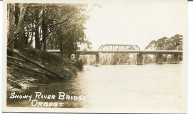
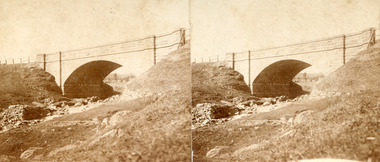
... of the Victorian Railways and the Country Roads Board at a cost of 35,000... of the Victorian Railways and the Country Roads Board at a cost of 35,000 ...This is a photograph of the second Snowy River Bridge at Orbost. The section in the central span could have been built after flood damage. This bridge over the Snowy River was opened on July 4 1922. It was constructed in 1922 alongside the previous suspension bridge. Its building was a combined effort of the Victorian Railways and the Country Roads Board at a cost of 35,000 pounds. It was replaced in 1976 by the present bridge after several major floods.This bridge was replaced in 1976 after several major floods.A black / white photograph / postcard of a bridge over a river. It has what looks like a bo girder in the central section. On the left is the river bank.on front bottom left - "SNOWY RIVER BRIDGE"orbost snowy-river-bridge transport-bridge -
 Melbourne Tram Museum
Drawing, Melbourne & Metropolitan Tramways Board (MMTB), "Route Map showing location of special work and pole numbers" "Electric Tramway Routes - showing routes in colours and numbers", late 1941
... cabins roads, railways and stations. Originally signed by Perway... crossovers, track layouts at junctions, signal cabins roads, railways ...Map of the system shown at two inches = 1 mile. Drawing No. P5799. Shows crossovers, track layouts at junctions, signal cabins roads, railways and stations. Originally signed by Perway Engineer - 20/12/1940, though originally drawn in 1922. Has been marked up in coloured pencil to show the routes and route numbers. The plan shows the lines to Maribyrnong Munitions works along Cordite Ave and Wests Road and the track from Moonee Ponds to Union Road, which opened in July 1941, but not the extension to Essendon Airport built-in 1942. See Reg Item 1561 for a 1963 version and 1683 for a 1987 versionDemonstrates the use of a MMTB drawing to show tram routes and their route numbers at the time.Drawings - dyeline cloth backed print - titled - "Route Map showing location of special work and pole numbers" and subtitled - "Electric Tramway Routes - showing routes in colours and numbers". trams, tramways, mmtb, trackwork, tramways, junction, map, world war 2 -
 Melbourne Tram Museum
Drawing, Melbourne & Metropolitan Tramways Board (MMTB), "Plan of Tramway System - showing route mileage of electric tramways", Late 1960's
... , automatic points, closed cable tram lines in the city area, roads...Melbourne Tram Museum 8 Wallen Road Hawthorn melbourne ...Drawings - dyeline print - titled - "Plan of Tramway System - showing route mileage of electric tramways" - Principal Junctions and intersections shown diagrammatically. Map of system shown at 40 chains to the inch. Drawing No. P6050. Shows crossovers, signal cabins, automatic points, closed cable tram lines in the city area, roads, railways and stations. Originally signed by Perway Engineer - 31-7-1951, last update March 1963. Has a list in the bottom left hand corner of abandoned cable tram lines. See Reg Item 1638 for a 1987 version and 3642 for a 1941 version.trams, tramways, mmtb, trackwork, tramways, junction, map -
 Surrey Hills Historical Society Collection
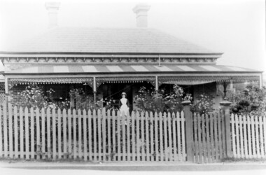
Photograph, Dr Blakie's home and surgery, 171 Union Road, Surrey Hills
... the land bound by the railway, Union Road, Wilson Street...', and originally owned all the land bound by the railway, Union Road ...The photo would have been taken prior to 1913 as Dr Blakie moved across the road to 174 Union Road to a purpose-built home/surgery designed by architect Arthur Plaisted. He practised at 171 Union Road joining or taking over from Dr Percy Liddle in 1905. The property was rented from the Zeplin family who built the house in 1890, which was known as 'Edgeware', and originally owned all the land bound by the railway, Union Road, Wilson Street and Montrose Street. in the 1920s to 1930s. 1906 became the home of Dr James Blakie, surgery was to the left of house. In 1912 Blakie had house built opposite (now Medical Centre). In 1920s-30s 'Edgeware' became Surrey Hills Police Station. Family details: James Blakie was born in New Zealand to a farming family of Scottish origin. He trained at Otago University with additional study at Cambridge. He married Catherine Miller Martin in 1906. They had 4 children: Geoffrey Noel (1906-1955); Raymond James (1907-1989); Theodore (1913-1913) and a daughter.Black and white photo of a Victorian style home with a slate roof, 2 chimneys, and a striped corrugated iron front veranda to 2 sides with decorative iron fretwork. It has a picket fence and an established garden with a central path leading to the front door. A woman, identified as Nurse Jones, is standing on the veranda.victorian style, homes, edgeware, house names, union road, montrose street, surrey hills, police station, zeplin family, professor zeplin, doctors, medical services, nurses, nurse jones, dr james landells blakie, dr percy liddle, mrs catherine miller blakie, raymond james blakie, geoffrey noel blakie, surrey hills police station, arthur plaisted, architects, edgeware, house names, 1890-1900 -
 City of Moorabbin Historical Society (Operating the Box Cottage Museum)
Newsletter, City of Moorabbin Historical Society No. 8 Vol. 5 November 1965, City of Moorabbin Historical Society No. 8 Vol. 5 November 1965, 1965
... ; Park Road Railway Crossing Gate Keeper; 1903 Railway Workers... Cheltenham by Jack McCarthy; Park Road Railway Crossing Gate Keeper ...This is Newsletter No 8 Vol. 5 produced in November 1965 by Mr T. A. Sheehy CMHS for members and visitors The Aims of the CMHS are ‘to record the history of the City, and register something of the Australian Atmosphere, which the necessary speed-up in post-world-war two (WW11) immigration has caused to be lost; to produce a magazine at regular intervals, featuring the work of pioneers and the changing Australian scene; to work constantly with a long range view towards building a hall where records and exhibits can be housed’ (1961) Topics ; Moorabbin Arts Festival; Memories of old Cheltenham by Jack McCarthy; Park Road Railway Crossing Gate Keeper; 1903 Railway Workers Strike; This is Newsletter No. 8 Vol. 5 of the CMHS November 1965 CMHS obtained a Kingston City Council Community Grant 2016 for the digitization and preservation of these Original CMHS Newsletters commenced in 1961 2 x L 26cm x W 21cm page 1 printed both sides CITY OF MOORABBIN HISTORICAL SOCIETY / AFFILIATED WITH THE ROYAL HISTORICAL SOCIETY OF / VICTORIA AND THE CHELTENHAM ARTS AND CRAFTS SOCIETY/ President Mr R. Ashley….Editor of Newsletter Mr T.A.Sheehy Secretary Mrs F.Neville / VOLUME 5 No.8 NEWSLETTER NOVEMBER 1965city of moorabbin historical society 1961, sheehy t.a., newsletters, neville f, ashley r, moorabbin city council, moorabbin arts festival 1965, mccarthy jack, charman road state school, victorian railways. railway workers strike 1903, judd clarrie, phonograph, -
 Magnet Galleries Melbourne Inc
hellfire corner, hellfire corner.tif
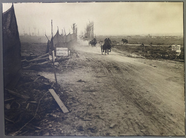
... -Zillebeke road and the Ypres-Roulers railway line crossed the road...-Zillebeke road and the Ypres-Roulers railway line crossed the road ...Hellfire Corner was a junction in the Ypres Salient in the First World War. The main supplies for the British Army in this sector passed along the road from Ypres to Menin - the famous Menin Road. A section of the road was where the Sint-Jan-Zillebeke road and the Ypres-Roulers railway line crossed the road. The German Army positions overlooked this spot and their guns were registered upon it so that movement through this junction was perilous, making it the most dangerous place in the sector.hellfire corner, ypres salient, war, road, ww1, world war 1 -
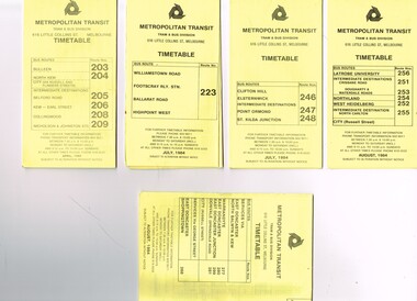 Melbourne Tram Museum
Ephemera - Timetable/s, Metropolitan Transit Authority (MTA), "MMTB Bus Timetables", 1984
... - Williamstown Road, Footscray Railway Station, Ballarat Road... - Williamstown Road, Footscray Railway Station, Ballarat Road ...Set of 5 Metropolitan Transit Bus timetables, folded sheets, generally 8 or 10 sections, providing timetables for specific routes, day of week giving information on tram times at specific time points, route map, sections and fares and organisation address - 616 Little Collins St. Melbourne. All printed on yellow paper unless noted otherwise. .1 - Route 203, 204, 205, 206, 208. 209 - Bulleen, North Kew, Belford Road, Kew, Collingwood and Nicholson and Johnson St - City - April 1984 .2 - Route 223 - Williamstown Road, Footscray Railway Station, Ballarat Road and Highpoint West - July 1984 .3 - Route 246, 247, 248 - Clifton Hill, Elsternwick, Point Ormond and St Kilda Junction - July 1984 .4 - Route 256, 251, 253, 254, 252, 255 - Latrobe University, Northland, West Heidelberg - City - Aug./ 1984 .5 - Route 277, 280, 299. 281 and 268 - services via East Doncaster, North Balwyn and Kew - Warrandyte, Donvale, Shoppingtown - August 1984trams, tramways, metropolitan transit, timetables, melbourne, fares, buses, footscray, latrobe university, northland, heidelberg, warrandyte, doncaster, donvale, bulleen, north kew, williamstown rd, highpoint, clifton hill, elsternwick, point ormond, st kilda junction -
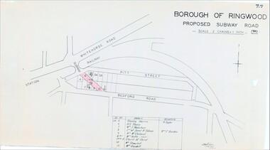 Ringwood and District Historical Society
Map, Borough of Ringwood, Victoria - Proposed Subway Road - 1943
... Road railway underpass into Pitt Street and Bedford Road... railway underpass into Pitt Street and Bedford Road. Includes list ...Technical drawing by D.H. Oliver dated 22/9/43 showing residential lots affected by proposed road extending from Warrandyte Road railway underpass into Pitt Street and Bedford Road. Includes list of owners and occupiers of properties - Lot 4 Stanley Harris /R. Taylor, Lot 6 R.S. Sharp, Lot 7 William J. Wakeham, Lot 8 Janet R. Gibson /Mrs C. Burden, Lot 9 Mrs McClelland, Lot 10 part Mrs. Yetts, Lot 11 part 10 Church of Christ, Lot 54 Mrs Shwerkolt, Lot 55 Mrs Goodall.Scale: 2 chains = 1 inch. -
Glen Eira Historical Society
Document - Memorials in Glen Eira
... Museum. - Rosstown Railway Marker, Bambra Road, Caulfield...’ in Caulfield Racing Museum. - Rosstown Railway Marker, Bambra Road ...This file contains one item: 1/A printout from the Victorian Memorials Database, undated and researcher unknown, containing records of 9 memorials in the Caulfield City municipality. These memorials are: - Caulfield Grammar School Site Pavement Marker, Elsternwick - Monument to racehorse ‘Jackstaff’ in Caulfield Racing Museum. - Rosstown Railway Marker, Bambra Road, Caulfield. - Thomas Alexander Browne Grave, Brighton Cemetery. - Grave of Sir John and Lady Monash, Brighton Cemetery. - Frederick Jowett Memorial Drinking Fountain, Caulfield Town Hall - Adam Lindsay Gordon Grave, Brighton Cemetery. - Jewish victims of World War 2 Memorial, Kadimah Centre, Elsternwick. - Hopetown Gardens Cannon, Elsternwick.historical markers, caulfield city, caulfield grammar school, elsternwick, regent street, caulfield racing museum, rosstown railway marker, caulfield, bambra road, curraweena road, marara road, city of caulfield, mayors, councillors, caulfield historical society, rosstown railway, caulfield grammar school pavement marker, monument to racehorse ‘jackstaff’, ross murray, browne thomas alexander, thomas alexander browne grave, brighton cemetery, rolf boldrewood, north road, caulfield south, browne margaret maria, grave of sir john and lady monash, monash john sir, monash hannah victoria lady, frederick jowett memorial drinking fountain, caulfield town hall, hawthorn road, glen eira road, jowett frederick, borough of caulfield, adam lindsay gordon grave, gordon adam lindsay, gordon annie lindsay, jewish victims of world war 2 memorial, kadimah jewish cultural centre and library, selwyn street, burston seddon, hopetoun gardens cannon, glenhuntly road, glen huntly road, schools, historic sites, plaques, footpaths, horseracing, horses, jackstaff, monuments and memorials, railways, authors, cemeteries, graves, gravestones, jewish community, town clerks, shire secretaries, town hall, drinking taps, poetry, children, libraries, world war 1939 – 1945, hopetoun, cannons, festivals and celebrations -
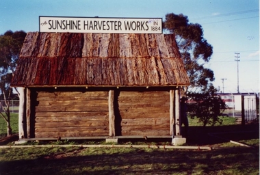 Sunshine and District Historical Society Incorporated
Replica of McKay Smithy, Opened on 10 October 2001
... gauge railway line the road outside the Smithy was demolished.... With the construction of the standard gauge railway line the road outside ...This Smithy is a replica of the building in which the first H. V. McKay harvester was built at Drummartin in northern Victoria in 1884. The original Smithy was moved from Drummartin to Sunshine Victoria where it remained for many years outside the H. V. McKay manufacturing plant. With the construction of the standard gauge railway line the road outside the Smithy was demolished, and the original Smithy was taken to the Melbourne Museum.The original Smithy is now in a fragile state and is no longer on public display at the Melbourne Museum. The site where the original Smithy stood in Sunshine was no longer available so the replica Smithy was erected a few hundred metres away, in the South East corner of Barclay Reserve on King Edward Ave, Albion 3020.The replica Smithy permits the public to view a full sized model of the building which eventually led to the formation of the H. V. McKay Sunshine Harvester Works. This firm grew to being considered the main manufacturing plant in the southern hemisphere, and also led to the local area being renamed in 1907 from Braybrook Junction to Sunshine.Brown wooden building with bark roof. This building is a FULL SIZED REPLICA of the original SMITHY that was used by H. V. McKay.THE SUNSHINE HARVESTER WORKS 1884smithy, h. v. mckay, sunshine harvester works, drummartin, replica, massey harris, massey ferguson -
Bendigo Historical Society Inc.
Map - KNOWSLEY : COUNTY OF BENDIGO, 7-11-1941
... Railway, Kilmore-Heathcote-Bendigo Road. Knowsley Station Ground.... Ida Creek or Wild Duck Creek, Sandhurst and Heathcote Railway ...Map. Knowsley, County of Bendigo, County of Rodney, Weston, Axedale, Eppalock, Knowsley East, Langwornor, Heathcote, Campaspe River, Mt. Ida Creek or Wild Duck Creek, Sandhurst and Heathcote Railway, Kilmore-Heathcote-Bendigo Road. Knowsley Station Ground. Shingle Hut Creek, Forest Creek. By authority H.E. Daw, Government Printer, Melbourne. Drawn and reproduced at the Department of Lands and Survey, Melbourne. 7-11-1941. Price 2/-. (number 103 in map cupboard 1)H.E. Daw, Government Printer, Melbourne.map, bendigo, knowsley -
 Ballarat Tramway Museum
Document - Photocopy, Neville Gower and Neville Hesketh, "Mayor's Report 1967-1968", Jul. 1997
... pages covering trams, railways, item on Country Roads Board (CRB..., railways, item on Country Roads Board (CRB) and traffic issues ...Photocopy of part of City of Ballarat's Mayor's Report for 1967 - 1968. Originals held in the Ballarat Library. Three pages covering trams, railways, item on Country Roads Board (CRB) and traffic issues in Ballarat and small photos of trams at City terminus. Page headed "City Traffic" added 19/12/2009 - and imaged along with following page which has the photo of the city tram at the terminus added. Looks at the introduction of traffic lights into the City and traffic problems and parking meters.trams, tramways, city of ballaarat, trams, railways, civic history, traffic lights -
 Melbourne Tram Museum
Drawing, Melbourne & Metropolitan Tramways Board (MMTB), "Footscray - City Tram Schemes - Perspective Overview", Dec. 1947
... and the length of double track. Shows roads, bridges, railway lines..., railway lines, docks, industry location, road cross sections ...Drawing - hand coloured - not formally titled - "Footscray - City Tram Schemes - Perspective Overview", shows existing tramways, proposed conversions, four different schemes or proposals and the length of double track. Shows roads, bridges, railway lines, docks, industry location, road cross sections and other planning features. Dated 4-12-1947, drawing No. P10868. Note pdf version of this drawing on the images file, but will not open with dbtext works pdf viewer. Converted to a jpg which does open.On left hand edge on the rear has in pencil - "Footscray - City Tram Schemes - Perspective Overview" P10868 1947 Spare (dup)trams, tramways, footscray, new tramway, north melbourne, spencer st, victoria st, bridges -
 Bendigo Historical Society Inc.
Document - ''HISTORY OF BENDIGO SALEYARDS''
... . Covers history from 1861; reference to abattoirs on site; railway... from 1861; reference to abattoirs on site; railway spur ...''History of Bendigo Saleyards''. This document is comprised of a paper titled 'Going, Going, Gone'' and as a history of the saleyards, appears to have been written /authorized by Mr John Quinlan (Convenor, Historical Field Day Committee, Department of Agriculture) see covering letter from C C Campbell, City Engineer. Covers history from 1861; reference to abattoirs on site; railway spur; Country Roads Board; Wellsford Forest site; Marong site. Other part of document is a list of various dates with short description of activity for that year from 1861 to September 1984 - this list is by M (Malcolm) Styles of City Engineers Department. Reference to Bendigo East Bowling Club; Bendigo East Swimming Pool.Mr John Quinlanbendigo, business, bendigo saleyards, mr a.m. lloyd, bendigo east bowling club, bendigo east swimming pool. -
 Ballarat Tramway Museum
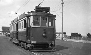
Photograph - B&W print of donated negative, Ron E. Fluck, 7/04/1950 12:00:00 AM
... is a stone wall of the railway tunnel under the road that served... of the photo is a stone wall of the railway tunnel under the road ...Black and white print of a donated negative. Print made 8/1998. Photo of Victorian Railway tram No.34 at the Brighton Beach terminus. Tram has the destination of "St Kilda Rly Stn". In the overhead can be seen the pan for assisting the driver to put the rear pole onto the wire. Also in the background of the photo is a stone wall of the railway tunnel under the road that served the Brighton Beach Pier. Photo taken 7-4-1950. See Victorian Railways to '62, pages 47 and 49 re railway tunnel.tramways, trams, brighton beach, vr, railway tunnel, tram 34 -
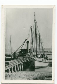 Orbost & District Historical Society
black and white photograph, before 1912
... :- "The Wongrabelle is completely covered in sand." (ref River, Road, Railway...:- "The Wongrabelle is completely covered in sand." (ref River, Road, Railway ...This photo shows the Storm Bird at the end of the jetty and the Wangrabelle in the foreground. Both ships were well known traders. the Wangrabelle became beached and wrecked in 1916 and the Storm Bird became obsolete when the railway from Bairnsdale to Orbost arrived in 1916. (ref. Story of Gippsland Shipping - J.C. Bull) At the start of the river trade goods were shipped from Marlo to Melbourne but when the railway reached Bairnsdale this became unprofitable and the ships plied only between Marlo and Cunninghame. Eventually river transport became economically unviable. The Wongrabelle is still buried in the sands of the entrance of the Snowy River (albeit where the entrance used to be). It took from April 11th 1912 to August 12th 1912 for the loss of the Wongrabelle to be complete, the final entry in the Orbost Shipping Co. records reads:- "The Wongrabelle is completely covered in sand." (ref River, Road, Railway Newsletter O.D.H.S.) This is a pictorial record of a time when the water highways were the only feasible transport mode in sending goods from Orbost and Marlo to Melbourne.A black / white photograph of a ship, sails down, anchored at the Marlo jetty.on back - "M. Gilbert, Wangrabelle at Marlo"storm-bird wangrabelle shipping transport- marlo -
Ballarat Tramway Museum
Document, Hector Bell Junior, "Street passenger transport system of Geelong Urban Area", 1949
... the Geelong railway station, additional roads to service the North... the Geelong railway station, additional roads to service the North ...Report by Hector H Bell Junior of the MMTB early 1949, titled "Street passenger transport system of Geelong Urban Area". Looks at the history of public transport in Geelong, tramway data, financial analysis, the Geelong bus system, buses servicing the North Shore industries - principally the Ford Works, the condition of the bus fleet, taxi and private car hire services, functions of a street transport authority, town planning, populations and traffic surveys, relative values of passenger vehicles, trolley buses, industry and recommendations. Said the tramway system was obsolete, should be a rail service between North and South Geelong, set up a street transport body, replan the Geelong railway station, additional roads to service the North Shore area. Refers to attachments. Has a list of people involved in the preparation of the report. See item 112 for the AETA response of April 1949 to this report.Yields information about the Geelong tram and bus services in 1948/49 and how it could be developed or reformed. Has a close association with Hector Bell Junior, the son of the then MMTB Chairman.Document - 18 foolscap sheets photocopied and stapled in three places along the side.tramways, secv, geelong, statistics, history, passenger services, reports, aeta -
 Ringwood and District Historical Society
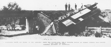
Photograph, Ringwood derailment on 11 Feb 1908 at Wantirna Rd. underpass looking north. Maroondah Highway near trees beyond underpass
... position of fireman McKeone when rescued. 2. View from the road... position of fireman McKeone when rescued. 2. View from the road ...Black and white photographs - 2 copiesPrinted directly below photographs, "1. overturned engine and tender at the 'dead end' which was carried away. The X indicates position of fireman McKeone when rescued. 2. View from the road. Railway accident at Ringwood". Typed below photograph, "Ringwood derailment 1902 at Wantirna Rd. underpass looking north. Maroondah Highway near trees beyond underpass". Date incorrect, should be 11 Feb 1908 (as per item 2019) - refer to The Argus article published on Wednesday 12 February 1908, page 7. Thanks to railway enthusiast Neal Glover for pointing out the error. -
 Melbourne Tram Museum
Document - Research Notes, H. S. McComb, "Extracts from the Minutes of the Prahran and Malvern Tramways Trust which was constituted under Act of Parliament No. 21030 in 1907", 1940's
... ., Dandenong Road lines, railway bridges, extension of High St to St...., Dandenong Road lines, railway bridges, extension of High St to St ...Original and carbon copy of "Extracts from the Minutes of the Prahran and Malvern Tramways Trust which was constituted under Act of Parliament No. 21030 in 1907", 10 foolscap sheets. Includes depot purchase, regrading of High St, extension to Burke Road, relocation of water mains, surveys, starting of construction, tenders for track and buildings, opening, extension, F. A. McCarty & Co., Dandenong Road lines, railway bridges, extension of High St to St Kilda Road, MMBW, finances. Items 2041 to 2052 within box 72.3 in a brown folder marked "PMTT" in red pencil.trams, tramways, pmtt, malvern, routes, track, surveys, malvern rd, tenders, construction, opening, dandenong rd, mmbw, finances -
 Melbourne Tram Museum
Drawing, Melbourne & Metropolitan Tramways Board (MMTB), "Plan of Tramway System - showing route mileage of electric tramways", Late 1960's
... area, Port Melbourne, roads, railways and stations. Has... tram lines in the city area, Port Melbourne, roads, railways ...Set of 9 A3 photocopy of a drawing - of a dyeline print that had been mounted onto a cloth backing and had been kept up to date with regard to extensions and closures or opening and closing - titled - "Plan of Tramway System - showing route mileage of electric tramways" - Principal Junctions and intersections shown diagrammatically. Map of system shown at 40 chains to the inch. Copy of Drawing No. P6050. Shows crossovers, signal cabins, automatic points, closed cable tram lines in the city area, Port Melbourne, roads, railways and stations. Has extensions to Mill Park up to April 1987. Shows the Port Melbourne, North Melbourne (Spencer and Abbotsford Sts) and Collingwood cable lines, the Footscray system lines and the Point Ormond lines. See also Reg Item 1561 for a late 1960's print and 3642 for a 1941 version.trams, tramways, mmtb, trackwork, tramways, junction, map -
 Bendigo Historical Society Inc.
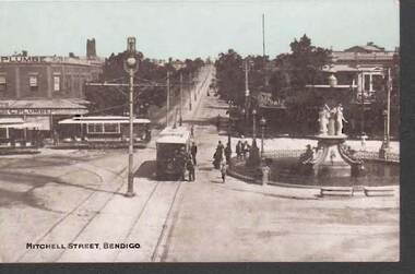
Postcard - MITCHELL STREET, BENDIGO
... Street, looking south east. Tram line runs up centre of road... Street, looking south east. Tram line runs up centre of road ...black and white photo, handcoloured blue sky. Mitchell Street, looking south east. Tram line runs up centre of road towards Railway Station. Two trams in Pall Mall, Alexandra Fountain on RH side. C. Plumbe , tailor, shop on corner of Pall Mall and Mitchell, LH side. Group of people standing near fence surrounding fountain, possibly waiting to get on tram. Man on horse riding down Mitchell Street. On rear of card: addressed to Miss Myrtle Dahlsen, Lake Tyers House, Lake Tyers, written in black ink. No stamp, 6/4/07 in pencil on top of card.bendigo, streetscape, mitchell street, bendigo, pall mall, alexandra fountain. -
 The Beechworth Burke Museum
Photograph - Stereoscopic Photograph, Unknown c1875
... that led to investment and development of roads and railways... in Australia's economy that led to investment and development of roads ...Depicted in the photograph is Newtown Bridge or the Newtown Falls Bridge, in Beechworth, Victoria. Noted for its location, detailed craftsmanship and stonemasonry by Scottish stonemasons the Newtown Bridge was built in the 19th century provincial town of Beechworth (completed in 1875). The bridge was built over Spring Creek, spanning 6.3 meters wide and 24.8 meters tall. Beechworth held a distinct role in the administrative and commercial management of Victoria's north-eastern goldfields, with many objects and structures still well preserved from the towns establishment. The bridge indicates the growth of the town, replacing a previous timber structure as well as its association to the mining activity in the area and the rapid increase in Australia's economy that led to investment and development of roads and railways. The local granite used in the construction of the single arch Newtown Bridge makes the bridge and other buildings made with the granite unique to the area, the honey-toned material distinct to Beechworth. This photograph is historically significant as it provides insight into the industrial development of Beechworth and the surrounding area, contributed to by the goldfields. The photograph further captures the representation of vernacular engineering traditions and Scottish stonemasonry.Two sepia-toned rectangular photographs featuring a bridge in the background printed on matte photographic paper mounted on card.Reverse: 97.2324/ Newtown Bridge/ Beechworthbridge, newtown beechworth, newtown bridge, newtown, beechworth, beechworth falls bridge, beechworth mining district, spring creek, -
 Orbost & District Historical Society
black / white photograph, 1897
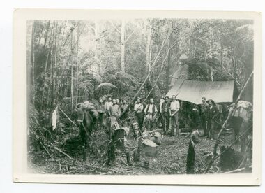
... Blacklock with a packhorse. They were surveying for a road... Blacklock with a packhorse. They were surveying for a road ...Link with item 1178. This is a surveyors' camp in the McCulloch Ranges, Murrangowar, April, 1897. Included in the photograph are: L. Thorn; Pearson; L. Coburn, Clem Bates; Sam Blacklock with a packhorse. They were surveying for a road or railway. Surveyors were among the first European settlers to arrive in Australia. A Surveyor-General was present on the First Fleet, as well as the first two ships which landed in South Australia. These men were issued with instructions to record observations in a journal that included the country’s general appearance, its soil, flora and fauna and the customs and language of local inhabitants. The conditions they worked in were harsh and they embarked on journeys with drays carrying cumbersome surveying and camping equipment, spending months camping out in the bush and mapping the land. It was not until well into the second half of the nineteenth century that the professional training of surveyors became mandatory in Australia.This is a pictorial record of a surveyors' camp in the late 19th century.A black / white photograph of a group of men standing in front of a tent / camp in a dense bush setting.surveyor's-camp-mccullochs-ranges-murrangowar land-settlement -
 Melbourne Tram Museum
Postcard, Rose Stereograph Co, "Melbourne from the Air", early 1940s
... skyline, railway yards, St Kilda Road, Yarra River and Princes..., railway yards, St Kilda Road, Yarra River and Princes Bridge ...Rose Series postcard No. P 622, titled ""Melbourne from the Air", Photo looking east over Melbourne with the Melbourne skyline, railway yards, St Kilda Road, Yarra River and Princes Bridge in the view. Three trams can be seen in the view in St Kilda Road. The building in the middle bottom of the photo is the recently completed Australian Provincial Assurance (APA) Assocation Limited Head Office on the south east corner of Collins and Queen Streets. This 1889 building was refaced and the tower added in 1928-1929. The adding of three additional floors to the Bank of Australasia building, 1875-1876, is well in hand 1929-1931 on the north west corner of Queen and Collins Streets. On the south east corner of the corner of Collins and Market Streets, the new Australian Mutual Provident (AMP) Society Head Office is reaching full height, also constructed 1929-1931. Yields information about an aerial view of Melbourne C1930Postcard - printed real photograph with Rose Stereograph Co. name on the rear.tramways, trams, aerial views, melbourne, collins st. -
 Bendigo Military Museum
Book - NOTE BOOK WW1, 1918
... rules. "R" Road Railway river recon report. "R" .303 Cartridge... rules. "R" Road Railway river recon report. "R" .303 Cartridge ...Full name: Robert Sinclair John Mackay, POB Caithness, Scotland. Training notes: "B" is about bearings - navigation. "G" is for guard duty, "H" is for human frame with drawing and notes - skull to toes - bones. "H" is for hemisphere - finding north in north and south hemispheres. "M" Map reading. "Q" Quarter master rules. "R" Road Railway river recon report. "R" .303 Cartridge design and Ballistics. "R" - duties of an R.S.M. "S" - Stretcher drill. Syphilis, Gonorrhea. "ST" is for stables routine. "W" is for words of command, Ambulance formations. At the very back of the book, is a list of numbers in 3 columns. Mackay enlisted on 8.9.1914 No 907 in the 3rd Light Horse Field Ambulance, embarked for Eygpt 2.2.1915, embark for Gallipoli 25.10.1915, Hospital 21.11.1915 (just said “Disc”) while in Eygpt he is hospitalised again with Bronchial Pneumonia rejoin unit 2.4.1916, hospital 6.11.1916 with Bruised Thigh, promoted Cpl 18.2.1918, hospital 4.8.1918 with Catarrhal Jaundice, rejoin unit 14.9.1918, promoted Sgt in the field 29.1.1919, hospital 26.4.1919 (unclear), hospital 20.6.1919 with Fractured right Disc, embark for England 23.7.1919, RTA 4.1.1920, Discharged from the AIF 22.2.1920. Pocket sized address book which has been used as a Training Exercise book. The cover is made of dark buckram. Inside are sections labelled A - Z, with lined pages or each section. First page has written in pencil: - “CPL ROBERT S. MACKAY, 907 3rd L.H.F.A. 3rd L.H. Brigade, A.M.D. MOASCAR 2 Jnay 1918”.ww1, lighthorse, training notes, 3rd field ambulance -
 Orbost & District Historical Society
black and white photograph, July 1922
... by road and railway traffic, but it was only used for road... by road and railway traffic, but it was only used for road traffic ...A new bridge over the Snowy River at Orbost was opened for traffic on June 20th 1922. It was designed for future joint use by road and railway traffic, but it was only used for road traffic. During the last few years the condition of an old suspension bridge [the 1893 bridge] which was the only vehicular crossing between the town of Orbost and the railway station, caused much concern. The structure was of timber, except for the wire suspension cables of its central span of about 100 feet. A design was prepared in 1914 for a permanent bridge with five spans of 85 feet composed of plate girders on concrete piers. With great increase in the price of steel work during the war, the cost of this design became prohibitive, and the need for a new structure becoming urgent, alternative proposals were investigated. As a result the present design was adopted as providing a sem-permanent bridge at moderate cost. The new bridge spans the river about 160 feet upstream from the old bridge on a slight skew, the piers being at an angle of 80 degrees with the centre line of the bridge. It has a camber of about 2 feet 5 inches in its total length of 527 feet. ( information from Newsletter March 2014 - Lois Crisp) The photograph shows Mrs James Cameron cutting the ribbon at the opening of the Orbost Pile Bridge in 1922. This second bridge, was built by the Victorian Railways and the Country Roads Board. Constructed at a cost of 35,000 pounds and used second-hand girders from the Flinders Street- Spencer Street viaduct. On July 4 1922 it was officially opened by Mrs James Cameron. Unfortunately, her husband, who had long championed the building of the bridge so that it would be ready for the railway to continue to the border, was too ill to attend the ceremony. In fact, James Cameron died on July 13 after a long and severe illness (ref. S.R.M. 20.7.1922). There is a section of this ribbon in the collection - Registration No. 366. This is a pictorial record of a significant event in Orbost's history.A black / white photograph of a pile bridge with a suspension bridge behind it. There are many people standing on the bridge.on back - "Opening of Pile Bridge - 1922"snowy-river-bridge ceremonies cameron-mrs