Showing 2472 items matching " township"
-
 Bendigo Military Museum
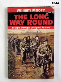
Book, The Long Way Round. Escape Through Occupied France, 1988
Black and red soft cover. Drawing on front cover of seven soldiers walking along a path with bombed township in the background. Author - WILLIAM MOORE Pages 182Written on front page "Donated by Bgo Y Mens Clubbooks-military-history, escape -
 Phillip Island and District Historical Society Inc.
Photograph, circa 1940
Commercially printed approx 1940s. Bayview Guesthouse (lower right foreshore) was burnt down in 1950s.Jetty diagonally lower left - township in foreground - open paddocks in background. Thompson Avenue & Cypress trees lower middle to upper right. Taken approx 1940sAerial view of Cowes Phillip Island No. 147local history, photography, photographs, slides, film, aerial views of cowes, phillip island, black & white photograph, aerial views cowes -
 Bendigo Historical Society Inc.
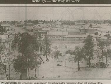
Newspaper - JENNY FOLEY COLLECTION: PROSPERING
Bendigo Advertiser ''The way we were'' from 2000. Prospering: The township of Eaglehawk in 1875 showing the main street, town hall and post office. The clip is in a folder.newspaper, bendigo advertiser, the way we were -
 Lakes Entrance Historical Society
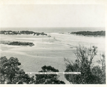
Photograph - The Entrance, Martin Orville, 1940c
Another copy Black and white 7 x 8.5 with inscription'View showing the Entrance, Lakes Entrance, Vic'Black and white photograph of Bullock Island, the New Works, township and entrance from Bass Strait to the Gippsland Lakes. Taken at high tide. Lakes Entrance Victoriaislands, waterways, topography -
Clunes Museum
Document - SHIRE DOCUMENT
COLLECTION MINUTES, ADVICE, RE CONSERVATION FOR TOWNSHIP OF CLUNES AND TALBOT RE LOCATION OR UNDER GROUNDING OF POWER AND REGISTER AND ATLAS OF LOCAL GOVERNMENT LAND USE ISSUESlocal history, document, conservation, talbot & clunes shire, heritage project -
 Bacchus Marsh & District Historical Society
Map, Bacchus Marsh Region Parish Plans: Folded set of maps
Set of Victorian Lands Department Parish Plans covering the township of Bacchus Marsh and surrounding districts. Folded. BMDHS Location: AR/SU27/D2: Map Drawersmaps bacchus marsh region, bacchus marsh victoria maps, interim record -
 Bendigo Historical Society Inc.
Postcard - Alice McGregor Postcard Collection, 1900 - 1920
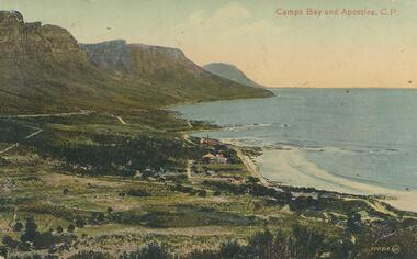
Alice McGREGOR Born: 1908; unknown parents. Possibly adopted by the Salter family? Electoral Roll 1936: Highland Terrace Kangaroo Flat. Alice Mary Salter and William Robert Salter living together; presumed to be sister and brother. William Robert Salter was killed in a MVA in Bendigo in 1937 aged 26. In Victoria in 1938, Alice Mary Salter married James Thomas McGregor (born Victoria 1917, died Victoria 1983, buried Fawkner Cemetery) Lived: 1968; 22 Wade Street Golden Square Alice McGregor Died: 1999 aged 91 at Anne Caudle Centre, Bendigo Buried: Kangaroo Flat Cemetery See additional research. Postcard Album of Alice McGregor contained 86 post cards.Postcard Album of Alice McGregor containing 86 postcards. See 1400 Colour photo of Camps Bay and Apostles, C.P., South Africa Small township on the bay. Addressee - Mrs. Gray, Vermont, Vic Sender - E. Branson Stamp dated 9 Dec 1919, Melbourne postcard, collector, alice mcgregor -
Lakes Entrance Historical Society
Book, LERHS, Bunga Creek School 3365, 2010
Folder containing sparse information about the Bunga Creek State School no 3365 which was situated a few miles north east of the township Lakes Entrance Victoriaschools, education -
 Clunes Museum
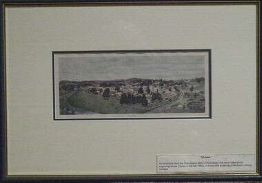
Print - ANTIQUARIAN PRINT, 1890
An illustration from the Picturesque Atlas of Australasia, hand-tinted photo-engraving by W.C. Fitler shows Clunes in late 1880's. It shows little evidence of the town's mining heritageTINTED RELIEF WOOD ENGRAVING PRINT OF THE TOWNSHIP OF CLUNES. HAND COLOURED, MOUNTED AND FRAMED WITH CREAM COLOURED MATT, DARK GREEN FRAME AND GOLD INSIDE TRIM.GENUINE ANTIQUARIAN PRINT LABEL ON BACK FROM LECKIE GALLERYwood engraving, relief, 1890, w.c.fitler -
 Melbourne Water
Photograph, Upper Yarra Dam Personnel, 1955
As the Yarra became unsuitable as a source of water, several attempts were made to find alternative sources for the growing population of Melbourne. It was not until 1891 that the efforts to sewer Melbourne came to fruition with the setting up of the Melbourne Metropolitan Board of Works (MMBW), now known as Melbourne Water. From 1891 until 1992, it was the responsibility of the MMBW to safeguard public health by providing a sewerage system and a safe water supply system. In 1992, The MMBW merged with a number of smaller urban water authorities to form Melbourne Water. In 1946, the Melbourne and Metropolitan Board of Works (MMBW) approved a site for a new dam for Melbourne's domestic water. This is now known as the Upper Yarra Dam. Due to the construction of the dam, the workforce had to be accommodated on site; domestic quarters were built for single men, families and staff. The township also had kitchens, laundry facilities, a canteen, a recreation hall, mess areas and a co-op store, with one of the first houses being seconded to accommodate for a school. This photograph shows personnel at a Kindergarten party at the Upper Yarra Dam, a time where workers were housed during its construction. The photograph is historically significant as it captures a purpose built community that supported the workers undertaking the construction of the dam. upper yarra dam, mmbw, melbourne metropolitan board of works, township, 1940s, community -
 Clunes Museum
Photograph, EDMUND STENDO, TOWN OF CLUNES, 1886
CLUNES TOWNSHIP IN 1886.1 BLACK WOODEN FRAMED PHOTOGRAPH OF CLUNES. HAND TINTED WITH A NARRATIVE WHICH WAS GLUED ONTO THE GLASS. VIEW LOOKING SOUTH NEAR THE PRESENT DAY SCENIC ROAD LOOKOUT. .2 BROWN WOODEN FRAMED PHOTOGRAPH OF THIS SKETCH. WITH MATT BORDER..1 TOWN OF CLUNES - Population 4874 - Number of dwellings 1100. Gold first discovered here 1st July 1851 Printed narrative: A hand-tinted photo-engraving from the Handbook of Victoria, published for the Colonial and Indian Exhibition in London, 1886. Looking south from near the present-day Scenic Road lookout, the illustration projects the image of Clunes as a goldmining town The view shows the headframes of several mine shafts, the Central Clunes Q.M.Co., and the Boundary, No.1 and No.2 shafts of the South Clunes G.M.Co. The headframe on the skyline in the middle distance was probably that of the Bute & Downes Amalgamated G.M.Co., near the railway station. .2 PAPER CERTIFICATE OF AUTHENTICITY ON REAR OF FRAME.colonial and indian exhibition in london 1886, bute & downes amalgamated, buildings, mining -
 Warrnambool and District Historical Society Inc.
Documents, Swintons Paper att 18/53 Merri St. Contract. Map. Notes, 1959
These documents relate to the sale of land in Merri Street Warrnambool in 1959 by Swintons Pty Ltd of Warrnambool. The buyer of the land was George O’Grady, a Warrnambool baker. The land sold for £4000 and there was a shed on the land (called the ‘Office’) which George O’Grady indicated he wished to be included in the sale. William and Ann Swinton migrated to Australia in 1854 and for a decade William Swinton worked as a builder and carpenter in the Warrnambool area, erecting many buildings, including the Wangoom Presbyterian Church. In 1865 he opened a store in Timor Street Warrnambool, selling groceries, hardware, china and glassware. By 1888 the business was known as William Swinton and Sons. Branch stores were opened in Wangoom, Cudgee, Nullawarre, South Warrnambool and West Warrnambool. After William Swinton died his son Robert became the first managing director of Swintons Pty Ltd. In 1934 the business split with George Swinton and Sons selling clothing, furnishings and glassware and Swintons Pty Ltd selling seeds, produce and hardware. Today the Swinton family still operates a furniture and bedding shop in Timor St Warrnambool.These items are of some interest as being connected to the Warrnambool business of Swintons Pty Ltd. They will be of interest to researchers. The current Swinton business in Timor Street is the oldest family business in Warrnambool and, with the name Swinton associated with businesses in Timor Street Warrnambool for 152 years it is amongst the oldest family businesses in Australia.The items here relate to the sale of land by Swintons Pty Ltd., Warrnambool. .1 These are three pages of white paper with typed material, a lawyer’s signature in blue ink, one green stamp and a sketch of the land location. .2 This is a sheet of thick paper containing a plan of the land sold. The paper has printed material and a sketch of the land with part of it coloured in pink. .3 This is a small piece of paper torn at the bottom right edge. It has handwritten material (a letter) in blue ink..2 ‘Plan of Survey of Part of Crown Allotment 18 Section 3 Township of .2 ‘Plan of Survey of Part of Crown Allotment 18 Section 3 Township of Warrnambool Parish of Wangoom County of Villiers’ .3 ‘Tuesday Dear Mr Swinton I am writing to say that I would like to have the ‘Office’ Thanking You George O’Grady’swinton family,, warrnambool -
 Phillip Island and District Historical Society Inc.
Photograph, 1969
One of 16 photographs and postcards donated by Mary KarneyBlack & White Aerial photograph of the two bridges linking San Remo with Newhaven, Phillip Island. San Remo Jetty and township bottom left foreground. Newhaven on the top.On back: "Two bridges San Remo 1969."the two bridges san remo, san remo to newhaven, phillip island bridges, mary karney -
 Bendigo Historical Society Inc.
Document - PLANS FROM LAND OFFICE , BENDIGO
Royal Historical Society of Victoria Bendigo and district branch. Plans from Land office, Bendigo. Four pages listing of parishes and two pages listing of Township plans. -
 Bendigo Historical Society Inc.
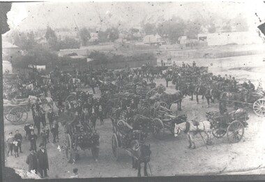
Photograph - HARRY BIGGS COLLECTION: HOSPITAL WOOD DAY
Photograph of the Hospital Wood Day at Eaglehawk. An overhead photo of people with horses and drays full of wood that has just been collected. In the background can be seen the Township of Eaglehawktopic, hospital wood day, horses, hospital wood day, eaglehawk -
Clunes Museum
Memorabilia - CALENDAR, R. FLETCHER & SONS. BALLARAT, 2013
1 x paper sheet of Clunes Fire Brigade printed in colour showing images of Clunes Town Hall, Clunes Township and the Government Bridge, (courtesy of Jenny Anderson)Nil2013, clunes fire brigade -
Tatura Irrigation & Wartime Camps Museum
Box of Maps, early 20th century
Maps are of the following: Toolamba (2), Toolamba West (2), Undera (2), North Murchison, Coomboona (2), Mooroopna, Waranga, Kyabram East, Girgarree East, Mooroopna West (2), Tatura and Goulburn irrigation district (pre 1956).Box containing maps of individual parishes in the county of Rodney, showing early selections. Also one of early Tatura townships with owners of many house blocks. 17 maps.each one is labelled with the parish (Toolamba, Tatura, , etc.) -
 Friends of Ballarat Botanical Gardens History Group
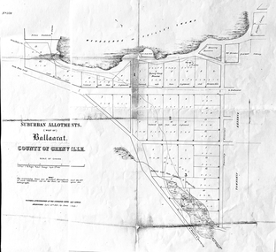
Work on paper - Suburban Allotments (west of) Ballaarat, Wendouree or Yuille's Swamp, County of Grenville 30/4/1856, 30/4/1856. No date given for photocopy
This map of the 1856 survey shows the numbered suburban allotments and the boundaries surrounding this area including Wendouree or Yuilles's Swamp close to where the Ballarat Botanical Gardens and the Lake exist today. This map gives a clear idea of an early survey of this western area and directions to areas of Ballarat surrounding these allotments.2 pages of the same map, except p.2 shows the Township Reserve on the lefthand side of the page. On the back of p.2, righthand corner is the Public Records Stamp.P2, righthand corner is the citation in pencil.john garner, doctor john garner, ballarat botanical gardens, friends of ballarat botanical gardens, map of western suburban allotments 1856, county of grenville, public record office of victoria, john garner collection, gardens, ballarat -
 Lakes Entrance Historical Society
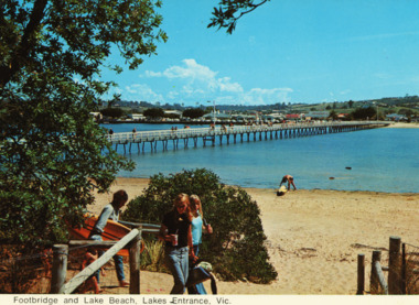
Postcard - Footbridge Cunninghame Arm, 1970 c
Colour postcards showing views of footbridge, part of Cunninghame Arm, east end of township and Myer Street hill in background and approach to ocean beach Lakes Entrance VictoriaFootbridge and lake beach Lakes Entrance Vicbridges -
 Fire Services Museum of Victoria
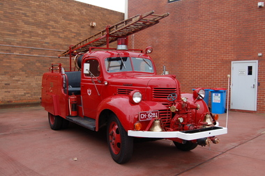
Vehicle - Fire Engine - Pumper "SEC Dodge", "SEC Dodge"
Maufactured for State Electricity Commission of Victoria (SEC) fire brigade at Yallourn township serving the nearby open cut brown coal mine, briquette manufacturing plant and electricity generating station. Donated to FSMV 19??, on closure of Yallourn Fire Brigade preparatory to closure of township to allow extension of open cut mine over township site.Unique only fire engine of design ever made.Pumper fire engine State Electricity Commission of Victoria (SEC) Fire Brigade, Yallourn, Vic Front mounted pump, ?, ? lpm [ ? gpm] Seat for 4 crew open cross mounted behind cab Ladder, ? m [ ? feet] Water tank ? l [ ? gall] Hose reel ? m [ ? feet] Current vehicle registration - CH6281 SEC logo on both doors Y F B on compartment door on both sides of bodyfire engine, fire engine pumper, dodge fire engine, dodge, yallourn fire brigade, sec fire brigade, yallourn, sec -
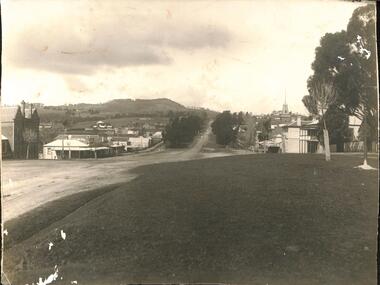 Buninyong & District Historical Society
Photograph - Original Photograph, Buninyong, from crossroads, 1924, 1924
record of township 1920'sB/W photo, Buninyong, from crossroads, 1924buninyong, crown hotel, learmonth st., warrenheip st, caffrey's shoeing forge, buninyong hotel -
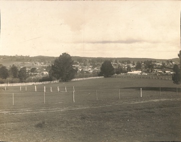 Buninyong & District Historical Society
Photograph - Original Photograph, View of Buninyong, 1920's, believed taken for Rose Post-card series, 1924
record of township 1920'sB/W photo, Buninyong, from crossroads, 1924buninyong -
Clunes Museum
book, HEDGES & BELL PTY. LTD, MARYBOROUGH 1854 - 1954 THE STORY OF A CENTURY, 1954
CARDBOARD COVERED BOOK OF MARYBOROUGH'S HISTORY. BY HAROLD V. NUNN 64 Pages, TITLED ' THE STORY OF A CENTURY'local history, book -
 Federation University Historical Collection
Photograph, Ballarat 1852
Photograph of a framed oil painting titled 'Ballarat 1852 Tent Settlement from Black Hill. Shows Ballarat Flat, Golden Point township. Black Hill Flat and Sebastopol.ballarat, black hill, golden point, ballarat flat, tents, settlement, black hill flat, sebastopol -
Phillip Island and District Historical Society Inc.
Newspaper clippings, 1888
Griffith Point had earlier been so named after Mr Griffiths, a fisherman.The Argus, July 9, 1888. At a public meeting, the inhabitants of Griffiths Point decided unanimously on the suggestion of Mr Fraser that the name of the newly proclaimed township should be named San Remo.local history, documents, newspapers, griffiths point, black & white newspaper clipping, griffiths point, the argus july 9 1988 -
Glenelg Shire Council Cultural Collection
Painting, George H.L Pentland, Casterton 1889, 1889
Casterton & District Historical Society Inc.Painting, oil on canvas showing a 'bird's-eye' view' of the township of Casterton in the late 19th century. It shows the Glenelg River, the bridge, main street and rolling landscape of the Western District.casterton, oil painting, landscape -
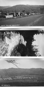 Kiewa Valley Historical Society
Photos - Mt Beauty and surrounds
B & W photos - Mt Beauty township; Earthmoving Equipment opposite workshops; Kiewa River; Mt Bogong view all with the titles written on the bottom left hand cornerKiewa River; Mt Bogong; Earth Moving Equipment; Mt Beauty -
Glenelg Shire Council Cultural Collection
Photograph - Photograph - Portland central township and Portland Harbour, 05/03/1971
Port of Portland Authority archivesFront: (no inscriptions) Back: (no inscriptions)port of portland archives, portland harbour, portland central town, no6 berth development, ocean pier demolition, baths demolition -
 Bendigo Historical Society Inc.
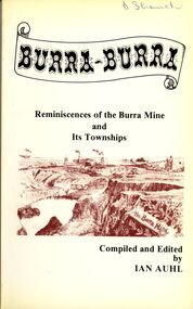
Book - STRAUCH COLLECTION: BURRA BURRA
Soft covered book titled Burra - Burra, Reminiscences of the Burra Mine and Its Townships compiled and edited by Ian Auhl, 160 pages with maps, black and white photographs & illustrations.Ian Auhlhistory, australian, burra burra, history-south australia-burra-mining -
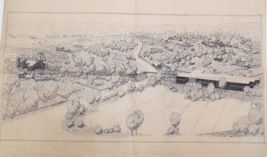 Bendigo Historical Society Inc.
Drawing - MINING IN BENDIGO COLLECTION: SKETCH OF MINING AREA
Pen and ink sketch of a mining scene. Sketch shows poppet legs and mine buildings, overhead mine structures, railway, township, miners cottages in a bush setting. Artist unknownart, mining in bendigo, sketch of mining area