Showing 1506 items matching "acres"
-
 Linton and District Historical Society Inc
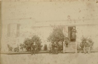
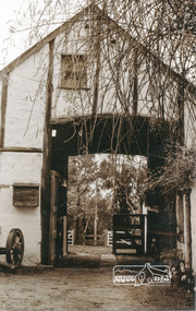
Photograph, Unidentified Family at Mt Bute Station, early 1900s
Mt Bute Station was a pastoral lease originally established c.1840 by Duncan Hoyle. The lease was later transferred to Charles and William Oakley (c.1853), and then to Matthew Hamilton Baird (c.1858). Sir Samuel Wilson acquired the lease in 1872 and purchased the property in 1873. Mt Bute was subdivided for soldier settlement blocks after World War I. The home block - house and 700 acres - is currently owned (2018) by the Collins family.Faded photograph mounted on cream-coloured card, which shows a family outside the residence at Mt Bute pastoral station. The photograph is undated but is believed to have been taken in the early twentieth century. Photograph shows two men, and a woman seated in chairs outside a house. A row of shrubs is across the front of the house. Two young boys are standing either side of the woman. Two young girls are standing on the steps leading to the entrance of the house. The people in the photograph have not been unidentified. A copy of the photograph was made in 2019 and is with the original.mt bute station [pastoral station] -
 City of Moorabbin Historical Society (Operating the Box Cottage Museum)
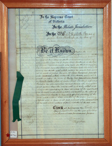
Document - Will of Elizabeth Avis-Box 1914, 1914
Elizabeth Avis- Box 1835-1913 was born in Sussex, married William Box in 1854 and arrived in Melbourne in 1855. William’s parents George and Mary Box and his siblings sailed with them. William & Mary at first leased land in the area of the ‘Dendy Special Survey Brighton 1841’ and then purchased the property with the pioneer cottage 1868 & 1869. William & Elizabeth established a market garden and raised 13 children. 1888 they built a larger 2nd house in front of the original cottage. William died in 1902 and Mary sold 9 acres in 1908 to W. .Snowden Anderson – it later became Joyce Park where the reconstructed Box Cottage Museum now stands. After Elizabeth died her daughters Ada and Violet lived on the 1 acre property until 1917 when August Reitman, a potter and monumental mason, leased the house and land. He established his pottery business and purchased the property in 1935. The business moved in 1953 but continued to use the cottage as a workshop/ storeroom until it was sold to Lewis Timber P/L in 1970. Elizabeth & William Box settled in the pioneer Cottage in Jasper Road East Brighton 1868 and established a market garden whilst raising their 13 children. This Cottage was reconstructed in Joyce Park, Ormond 1984 and is the home of City of Moorabbin Historical Society. In 1960 many local residents responded to a call for the donation of historical artefacts and the Box Cottage Museum now preserves this eclectic collection for the community.The original Last Will & Testament of Elizabeth Avis Box September 1914In the Supreme Court / of Victoria / In the Probate Jurisdiction / In the Will of Elizabeth Box late of / Jasper Road Bentleigh in the State of / Victoria Widow deceased. Be it known ............. Given at Melbourne this ( 21st September 1914) Signed A Carter / Registrar top left corner 79637 / Snowball ( X232) Bottom left corner 10/9/...box elizabeth, box william, moorabbin, bentleigh, brighton, ormond, pioneers, market gardeners, box george, box mary cripps, reitman august, anderson w. snowden, joyce park ormond, box cottage museum dendy’s special survey brighton 1841, -
 Mt Dandenong & District Historical Society Inc.
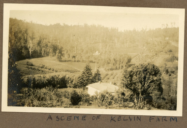
Photograph
Most likely a scene of 'Mt Calvin', the homestead built by John William (Willie) Richardson for his wife Jeanie Green of Wandin. The house was built c1898 The Rowse family purchased the house and 60 acres when Willie and Jeanie Richardson with their 3 children moved to Brisbane. The Rowse family farmed the 60 acres for 35 years and the house was demolished in 1938. The photograph is from the album of Ivy May Child. Ivy May Child (1910 – 1989) was the daughter of Arthur Edward (Ted) Child (1878 – 1964) and Ethel May Madden (1888 – 1970). Ted Child was the son of Matthew Francis Child (1839 – 1933) and Martha Jeeves (1857 – 1926). He was the grandson of one of the early pioneers Francis Child. Ivy grew up on the family property on Childs Road and took many photographs. Most of these are glued into her photo album. The album covered the years from c1927 – 1932. Ivy married Henry William Burgess (1906 – 1968) in 1944. The photographs remain in their original state in the album with individual copies made. Black and white photograph with a house in the foreground looking over cultivated fields with treed hills in the background. A building is visible in the centre in the distance.Written below the photograph in the album" A SCENE OF KELVIN FARMmt calvin, kelvin farm, calvin farm, richardson, rowse, jeanie richardson, john william richardson, willie richardson -
 Wodonga & District Historical Society Inc
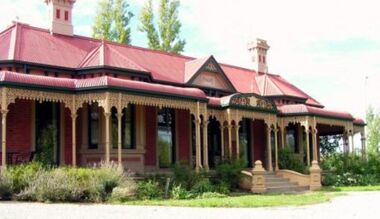
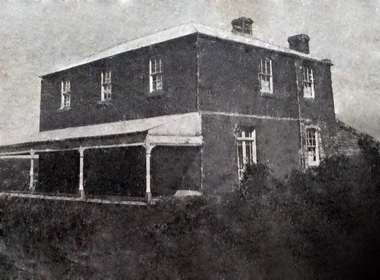
Photograph - Cambourne House
Cambourne homestead was built by 1903 for Rebecca S. Carkeek, who purchased the property in Wodonga in 1899. Cambourne is situated on the original Wodonga Run which was established in 1836. In 1855 the pre-emptive right of 171 acres of the Wodonga Run was granted and sold the following year. The allotments on which the five-acre Cambourne property developed, were purchased in 1873 and 1876, coinciding with the opening of the Railway from Melbourne. The property was purchased by Rebecca Carkeek in June 1899, wife of William Carkeek, Publican of Wodonga and Shire Councillor. Local architects Gordon and Gordon have been credited with the design of Cambourne. The house at Cambourne was built at some stage between 1900 and 1903 as a large single storey homestead. It was constructed in red brick with corrugated iron roof and encircling verandah. Cambourne is a probable work of architects Gordon and Gordon, it is amongst their best preserved and one of their few surviving buildings in Victoria. Today Cambourne remains on a reduced allotment due to the acquisition of land in 1972 by the Country Roads Board and in 2006 by Vic Roads for road works adjacent to the property.Cambourne, Wodonga is of architectural and historical significance to the State of Victoria.A set of coloured photos depicting Cambourne in Wodonga. Part of a collection documented a heritage listed pioneer home.cambourne wodonga, cambourne homestead wodonga, historic buildings wodonga -
 Bendigo Historical Society Inc.
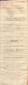
Document - JOHANSON COLLECTION: GRANT BY PURCHASE WILLIAM ROBERTS
Legal document. On front: Dated 17th December 1855. Ac1 R1 P 1. ( acres, roods, perches ) Grant by purchase to William Roberts. In pencil Allot 7 of Sec 12. Inside: 'Victoria - Township Lot. Grantee W. Roberts. Document details purchase of land by above William Roberts of Heathcote, for the sum of two pounds, 12 shillings. Allotment 7, section 12, Township of Heathcote. Land sold as Lot 14. Dated 30 July 1855. Signed by C.W. Hotham ( Sir Charles Hotham ) Property is now 42 Beauchamp Street, Heathcote ( Landata research, 28.3.2017, https://www.landata.vic.gov.au/tpc_confirm_map.aspx?pfi=45257085 )heathcote, land sale, william roberts -
 Wodonga & District Historical Society Inc
Album - Hume Reservoir Australia Album - Driving first row of piles for coffer dam across the river, December 1925
This set of photos is from a leather bound album bearing the inscription "HUME RESERVOIR AUSTRALIA" plus 'The Rt. Hon. L. C. M. S. Amery, P. C., M .P.' all inscribed in gold. It was presented to The Rt. Hon. L. C. M. S. Amery, P. C., M. P, Secretary of State for Dominion Affairs on the occasion of his visit to the Hume Reservoir on 2nd November 1927. This album is of local and national significance as it documents the planning and development of the Hume Reservoir up to 1927. It was the largest water reservoir in the British Empire. The album records the pioneering engineering work that went into its construction.DEPARTMENT OF PUBLIC WORKS, N.S.W. RIVER MURRAY WATERS SCHEME. HUME RESERVOIR. 19. Driving first row of piles for coffer dam across the river. New South Wales. December 1925. Cofferdams are temporary structures used where construction is being carried out in areas submerged in water. They are most commonly used to facilitate the construction or repair of dams, piers and bridges. To divert the river, a Coffer Dam was built across the old bed above and below the Dam site and tying into the end of the concrete wall built inside the levee bank. This completely surrounded the remainder of the site of the Dam and south wing wall, including an area of 12½ acres. hume reservoir australia, river murray waters scheme, hume reservoir construction -
 Bendigo Historical Society Inc.
Document - VICTORIA HILL - VISITOR PLANS FOR VICTORIA HILL
Handwritten carbon copy and typed copy of notes on 1st and 2nd stage plans for a tourist area on approx. 20 acres at Victoria Hill. First stage was to clean up the area, locate and sign post shafts, engine beds, etc and prepare a topographical map with these features on it. Second stage was to arrange for the purchase of typical miners homes and shops in the vicinity to be restored for inspection by visitors. Mining equipment to be placed in the area. Prepare brochures for sale. Set up a mining museum.Prepare an area near BCV 8 with direction finder to mining and general features, as this has the best natural ground level view in the City. Notes prepared by Albert Richardson.mine, gold, victoria hill, victoria hill, visitor plans for victoria hill, darrel mcclure, bendigo city council, bendigo historical society, central nell gwynne, caleb thomas, bcv 8, lazarus, old chum, new chum, victoria, repeater station (p. m. g.) -
 Eltham District Historical Society Inc
Work on paper (item) - Photograph, 2 Metery Road, Eltham South
Robert and Ada Zull built an Alistair Knox designed house at 2 (lot 8) Metery Road, Eltham, a one acre property for their family of five in the mid 1960s. This series of photographs shows the one story house towards the end of its construction. Susan Bennett, nee Zull's reminiscences are published in EDHS Newsletter, February and April 2020. "..The block was big.. Building the house was slow going...the house had a concrete floor and a roof, but no windows..."This series of photographs together with the account of personal remiscences provide a unique document of the construction of an Alistair Knox designed home. Knox was a pioneer in the use of mudbricks and recycled materials and is significant to his contribution of this style of architecture in Eltham and the wider Shire of Nillumbik.zull family, eltham south, 2 metery road, alistair knox, bush block, construction, vw beetle -
 Greensborough Historical Society
Photograph, Partington's Flat Greensborough Circa 1968, 1968_
Partington's Flat Greensborough was created in the 1950s when Heidelberg Council bought 12 acres from the Partington family to make the park. Fruit trees can be seen in this photograph. Gary Partington (on 2/2/2017) was hazy on the precise locale of the photo. It may have been a track from Willis Vale house going toward the Plenty River with maybe Marsh's Pine trees in the right background defining the border fence line of the Marsh Farm.Colour photographHandwritten on back "Partington's Flat Greensborough about 1968"alan partington, greensborough, partingtons flat, farms, landscapes, gardens -
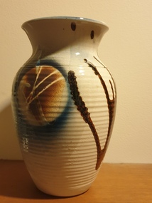 Ballarat Heritage Services
Ceramic - Artwork - Ceramics, Pottery Vase by Mark Reid
Mark REID Mark Reid began working with clay in the early 1980s, working for a time at Kairi Pottery in North Queensland. In 1985, he and his wife Robyn set up the Torvil Pottery at Buninyong, Victoria. In 1991, they relocated to a 10 acre property in nearby Magpie and set up the Ballarat Clayfire Gallery with a working studio, gallery and residence. In 2005, the Clayfire Gallery was located to Daylesford. Reid signs his work with an incised 'Mark Reid' or 'MR'. Photograph of a hand thrown ceramic vase. australian landscape pottery, gilbert buchanan, graham wood, landscape, redbyrne pottery, ceramics, shepparton, torvil pottery, ballarat clayfire gallery -
![Map, [Coornmill land area available for leasing for grazing, Parish of Coornmill]. Circa 1904](/media/collectors/5e461d8021ea67224c82f2a1/items/677cde147f2053f3e5d277c3/item-media/677cdeea7f2053f3e5d27bb4/item-fit-380x285.jpg) Bacchus Marsh & District Historical Society
Bacchus Marsh & District Historical SocietyMap, [Coornmill land area available for leasing for grazing, Parish of Coornmill]. Circa 1904
This map shows an area of land north of Bacchus Marsh in the Larderderg State Park area known as the Parish of Coornmill.The map indicates an area of land which was to be made available by public tender for grazing leaseholders. The plan to do this was discussed in the Bacchus Marsh Express newspaper on the 16 July, 1904, page 2, column 7. The area reserved for grazing leases is identified by red lines on the map. The Express described the area available for grazing was 12,000 acres.A single page paper map showing an area of land in the Parish of Corrnmill to be made available for grazing leases. A photo lithographed Lands Department Map. No scale indicated. The map is pasted into a bound volume containing 76 maps or plans in total. High resolution digital image stored on BMDHS computer network. coornmill parish maps, lerderderg state park maps, agriculture bacchus marsh area -
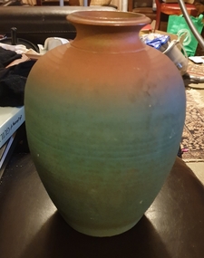 Ballarat Heritage Services
Photograph, Vessel by Mark Reid, 1989
Mark Reid began potting in the early 1980s, working for a time in North Queensland. In 1985, he and his wife Robyn set up the Torvil Pottery at Buninyong near Ballarat in Victoria. In 1991, they relocated to a 10 acre property in nearby Magpie and set up the Ballarat Clayfire Gallery with a working studio, gallery and residence. In 2005, he Clayfire Gallery was located to Daylesford. Mark Reid signs his work with an incised 'Mark Reid' or 'MR'.mark reid, australia studio pottery, ceramics, torvil pottery, buninyong, magpie, clayfire gallery, ballarat clayfire gallery, daylesford -
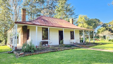 Old Gippstown
Building - Bushy Park
13 August 1843 First application for the Bushy Park run appeared in the “Port Phillip Gazette”. It was taken up by Angus McMillan, who took up the Boisdale run across the Avon River at the same time, for his employer Lachlan Macalister. This house was built in 1848. March 1844 Licence to Bushy Park granted to McMillan. It consisted of 16,000 acres. Late 1840s Bushy Park homestead built for McMillan by Andrew Martin and Matt McCraw. High local historic significance as associated with major pioneer and a very old white settlement in Gippsland.A square shaped timber house, with a corrugated iron roof over shingles. It has a verandah that covers both the front and sides of the house. The house is contructed of redgum timber, and internally has four rooms.National Trust of Australia Plaque - Bushy Park Homestead - Class 'C'mcmillan, angus, old gippstown, west gippsland, gippsland, gippsland heritage park, goldfields, victorian era, moe, historical village, wellington shire, avon river, boisedale, briagolong, dargo, murdoch mackintosh, national trust, andrew martin and matt mccraw., latrobe valley, old gippstown heritage park, gunaikurnai, latrobe city council -
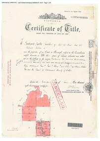
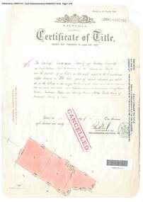 Ringwood and District Historical Society
Document, Certificate of Title - Crown Sections 12, 15, and Part of Section 20 (later including Warranwood, Vic.), Parish of Warrandyte, County of Evelyn - 11 June, 1898
A4 copies of Landata Victoria Historical Search documents - Vol 2687 Fol 537231.The Mutual Assurance Society of Victoria Limited of 406 Collins Street Melbourne, County of Bourke, is now the proprietor of an Estate in Fee-simple - 1,640 acres 3 roods 31 perches or thereabouts, being Crown Sections 12, 15, and part of Crown Section 20, Parish of Warrandyte, County of Evelyn. TRANSFER - 13th March, 1899 - 17ac 3rds 5per to The President Councellors and Ratepayers of the Shire of Lilydale (Part of Crown Section 20). -
 Ringwood and District Historical Society
Document, Certificate of Title - Crown Allotments 4A, 4B, 11A, 11B, and Crown Sections 5 and 6 (later including Wonga Park, Vic.), Parish of Warrandyte, County of Evelyn - 17 June, 1895
A4 copies of Landata Victoria Historical Search documents - Vol 2574 Fol 514725.Frederick Walter Purches of Ascot Vale, Wholesale Butcher, is now the proprietor of an Estate in Fee-simple - 2,291 acres 3 roods 24 perches or thereabouts, being Crown Allotments 4A, 4B, 11A, 11B, and Crown Sections 5 and 6, Parish of Warrandyte, County of Evelyn. Transfers include The Mutual Assurance Society of Victoria Limited, 15th August, 1896, The President Councellors and Ratepayers of the Shire of Lilydale, 13th March, 1899. -
 Eltham District Historical Society Inc
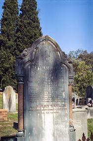
Negative - Photograph, Harry Gilham, Grave of Abraham and Ann Taylor, also Mary Taylor, Eltham Cemetery, Victoria, Sep 2009
Abraham Taylor was born 20 October 1811 in Derrycarn, Drumcree Parish, County Armagh, Ireland, the son of Richard William Taylor and Annie Abraham. He married Ann McClelland on 19 February 1852 in Dumcree. They emigrated to Australia arriving in Geelong aboard the Ann Thompson on Christmas Day, 1852. His younger sisters Mary and Martha and brother William John all having separately preceded them in 1851 and 1852. Abraham and Ann settled in Little Eltham, Abraham was recorded as being 40 years of age and Ann, 36. They made their home and living as an orchardist and gardener where they had three sons, William John (1853 Little Eltham), Richard (1855 Eltham) and Robert David (1857 Eltham), tow of whom became Councillors of the Shire of Eltham; William (1890-1911) and Robert David (1911-1920). In June 1871, Abraham Taylor, Eltham gardener, applied for a 120-acre allotment half a mile northeast of the Research Gully Hotel on June 30, 1871. A license was issued to him January 30, 1872, for 114 acres, being Allotment 8, Section 18, the balance of 6 acres being retained for reserve. He built on the land a two roomed dwelling of slabs and palings. He and his family lived there or at their 6 ½ acre Eltham property, which was used for orchard and garden as a residence. In January 1875 a lease issued to Abraham Taylor for the land one chain wide each side at the gully named ‘Wet Gully’ was excluded. In August 1881 Abraham Taylor paid up all fees and applied for a Crown grant. He vainly requested that the grant be issued to his son, Robert David Taylor, Eltham however the grant was in fact issued to Abraham Taylor, Eltham, gardener. Abraham died at home on June 1, 1890. He was greatly respected by all who knew him. His sister Mary predeceased him 1873and is also buried at Eltham cemetery. Wife Ann died at home 1 September, 1893 and was buried with him. In Loving Remembrance of Abraham Taylor Who died June 1st 1890 Aged 80 years Also Ann Taylor Wife of the above Who died September 1st 1893 Aged 75 years Also Mary Taylor Who died September 22nd 1873 Aged 45 yearsRoll of 35mm colour negative film, 6 stripsKodak GC 400-9eltham cemetery, gravestones, abraham taylor, ann taylor, mary taylor -
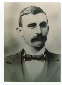 Orbost & District Historical Society
black and white photograph, C1936
This is a photograph of Councillor Hamilton Rutherford Reed who represented North Riding 1918 - 1936. Hamilton Reed was an early settler at Goongerah. In 1868 Hamilton Reed and John Locke both of Bendoc secured a grazing area of 60,000 acres at Goongerah. About the year 1878 Hamilton Reed and C. W. Nicholson decided to, if possible, to go from Bendoc to Orbost via Goongerah, they accomplished the task in 4 days from Goongerah. (more info. Newsletter September 2004)This item is associated with the Orbost Shire Council. The shire covered an area of 9,347 square kilometres and existed from 1892 until 1994 when it became part of the East Gippsland Shire Council.A black / white head and shoulders portrait photograph of a moustached man in a suit. There is also a framed photograph.on back - "Cr H.R. Reed, North Riding 1918-1936"reed-hamilton-rutherford goongerah-history orbost-shire-council -
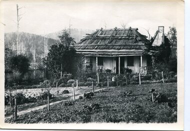 Orbost & District Historical Society
black and white photograph, late 19th century - early 20th century
This is a photograph of the home of Hamilton Reed who was an early settler at Goongerah. In 1868 Hamilton Reed and John Locke both of Bendoc secured a grazing area of 60,000 acres at Goongerah. About the year 1878 Hamilton Reed and C. W. Nicholson decided to, if possible, to go from Bendoc to Orbost via Goongerah, they accomplished the task in 4 days from Goongerah. (more info. Newsletter September 2004) Councillor Hamilton Rutherford Reed represented North Riding 1918 - 1936.This item is associated with Hamilton Reed an early settler of Goongerah who was a long -time member of Orbost Shire Council.A black / white photograph of a settler's wooden home surrounded by a garden. The house is made of upright slabs for the walls and has a stringy bark roof.reed-hamilton goongerah -
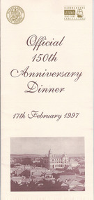 Warrnambool and District Historical Society Inc.
Document, Menu 150th, 1997
This is the program for the dinner celebrating Warrnambool’s 150th anniversary. Warrnambool was established in 1847 as a planned town in response to the need for a new port to be established to service the pastoralists who had occupied land nearby. Superintendent La Trobe authorized the establishment of the town and probably gave it its name. The surveyor of the 250 acre grid that today comprises most of the Central Business District was William Pickering. The 150th anniversary celebrations were organized by an 150th Anniversary Committee headed by Frank JacobsThis program is of minor interest as a memento of the important 150th anniversary celebrations held in Warrnambool in 1997. This is a buff-coloured A3–size sheet folded into three to make six pages of printed material. These include sepia-tone photographs, the menu for the dinner, the official crest of the Warrnambool City Council and the 150th anniversary celebrations logoFront cover: ‘Official 150th Anniversary Dinner, 17th February 1997’warrnambool’s 150 anniversary celebrations -
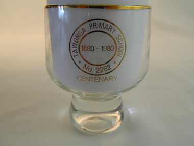 Kiewa Valley Historical Society
Trophies - Glass - Tawonga Primary School, 1980
The Tawonga Primary School was a weatherboard building built on 8 acres. In 1900 a fire destroyed the building and its records. The school was then moved to the Old Tawonga Hall before a new one was built in 1910 on land donated by Frank Cooper. In 1937 and 1954 further buildings were added. Tobacco farming and the building of the Kiewa Hydro Electric Scheme increased the number of pupils during the 1950s and 1960s. This glass represents the celebration held when the school became 100 years old.Tawonga Primary School was established for the children of the farmers of the Kiewa Valley in 1880 and later for children of the tobacco farmers and workers on the Kiewa Hydro Electric Scheme. The history of the school reflects the activities of the people living in the valley and in particular Tawonga township.Clear glass with gold metal brim and embossed in gold on two sides. Base is solid tapering up to the glass sides.On one side: Gold embossed picture of school building On opposite side: Gold embossed 2 circles - Inside inner one: 1880 - 1980. Between this and outer circle - Tawonga Primary School No 2282. Underneath both circles gold embossed: Centenarytawonga primary school, kiewa valley, education -
 Eltham District Historical Society Inc
Work on paper (item) - Photograph, 2 Metery Road, Eltham South
Robert and Ada Zull built an Alistair Knox designed house at 2 (lot 8) Metery Road, Eltham, a one acre property for their family of five in the mid 1960s. The form of the house is laid out on the cleared block. There was a dam at the bottom of the block. Susan Bennett, nee Zull's reminiscences are published in EDHS Newsletter, February and April 2020. ".. the block was big.. Building the house was slow going. The plans had to be discussed, then drawn up, finance found, council permits obtained and labourers engaged. " This series of photographs together with the account of personal remiscences provide a unique document of the construction of an Alistair Knox designed home. Knox was a pioneer in the use of mudbricks and recycled materials and is significant to his contribution of this style of architecture in Eltham and the wider Shire of Nillumbik.zull family, clearing, eltham south, 2 metery road, alistair knox, bow and arrow -
 Eltham District Historical Society Inc
Work on paper (item) - Photograph, 2 Metery Road, Eltham South
Robert and Ada Zull built an Alistair Knox designed house at 2 (lot 8) Metery Road, Eltham, a one acre property for their family of five in the mid 1960s. Concrete footings are poured. The house had a concrete floor. Susan Bennett, nee Zull's reminiscences are published in EDHS Newsletter, February and April 2020. ".. the block was big.. Building the house was slow going. The plans had to be discussed, then drawn up, finance found, council permits obtained and labourers engaged. " This series of photographs together with the account of personal remiscences provide a unique document of the construction of an Alistair Knox designed home. Knox was a pioneer in the use of mudbricks and recycled materials and is significant to his contribution of this style of architecture in Eltham and the wider Shire of Nillumbik.zull family, eltham south, 2 metery road, alistair knox, bow and arrow, footings, concrete, concrete mixer -
 Eltham District Historical Society Inc
Photograph, Stables, Montsalvat
Photograph of stables at Montsalvat, Eltham. Montsalvat is an artist colony, established by Justus Jorgensen in 1934. It is home to over a dozen buildings, houses and halls set amongst richly established gardens on 48,562 m2 (12 acres) of land (Wikpedia). "Many of the buildings (including.. the stable near the animal yard) were designed by Justus Jorgensen in Gothic and/or vernacular styles using mud brick and recycled materials" - Victorian Heritage Database Photo possibly taken by Peter Bassett-Smith. No date. Montsalvat is historically, technically, architecturally, aesthetically, socially and spiritually significant to the State of Victoria.The Montsalvat complex is historically significant because it was established in 1934 by the noted artist and architect Justus Jorgensen. (Victorian Heritage Register)1 photographeltham, montsalvat, stables -
 Orbost & District Historical Society
register, Register of Residence Areas, 10.2.1897 - 4.9.1934
This book is a register of land holders with miners' rights. The correspondence is associated with applications for miners' rights on privately owned land and business sites. They include application fotrms and objections to registrations. The areas referred to are Combienbar, Goongerah, Club Terrace, Wombat Creek and Dundong. One of the privileges under the Mines Act, conferred by the holding of a miner's right until 1935 was that of residence on up to one acre on a gold-fields area. Those occupying a residence area were "deemed in law to be possessed ... of such ... parcels ... and the property therein".This is a useful research tool.A large, heavy book with a grey cloth cover and red spine. The end papers are marbled. The inside pages are ruled in grey with red ruled columns. Entries are hand-written. There are copies of correspondence inside. Details given are the registration number and date, the name of the person, the number of the miner's right and its date, a description of the allotment and any remarks or references to other volumes. Any changes of ownership are shown. The book is mostly unused.register-mining miners-rights -
 Federation University Historical Collection
Document, Anne Beggs Sunter, Green Hill History, c2001
The Green Hill settlement dates from the 1860s. Developers in the 1960s chose to call it Mt Helen rather than Green Hill. Mt Helen is believed to be named after Helen Hastie, the daughter of Reverend Hastie of Buninyong. In 1866 a 241 acre site was purchased for a new tertiary institution. It is now known as the Federation University Mount Helen Campus. Green Hill is a scoria dome and though dominated by Mt Buninyong (Elevation 2442 feet) it is thought to have been formed earlier. Three pages History of Greenhill by Anne Beggs Sunter, and two further pages of notes.greenhill, green hill, mount helen, mt helen, mt helen campus, federation university, elizabeth downing, george dean, latta, davis, skelton, watkins, john latta, elizabeth latta, william watkins, pontresina, rabits, dr longden, abraham baxter, noel robson, jane robson, george inglis, mt helen railway station, ballarat technology park, g. dean, green hill wesley church, jim downing, bob thornton, stapleton, hately, martin fanning, toll keeper, ralph fiscalini -
 Torquay and District Historical Society
Photograph (copy), Bellbrae Cemetery Memorial Exhibition 2015
Photograph shows Llanberris House, built by Joseph and Mary Gundry on Iron Bark Station, west of the Anglesea Geelong Road, off Menzels Road above Spring Creek. The Gundrys took up Iron Bark station in 1844 and subsequently bought up more surrounding land. Just prior to Joseph's death in 1878, the property comprising 7721 acres was offered for sale as well as conditional rights to adjoining land. Llanberis House was a substantial stone dwelling of 2 storeys with 11 rooms.The Gundry family was one of the pioneering European settlers in the Bellbrae Torquay area.Black and white photographbellbrae victoria pioneer families -
 Bendigo Historical Society Inc.
Document - Fortuna Villa - The Past and the Future
Theodore Batterstedt and his father bought five acres of land on which they built a quartz crushing mill and a two storied, 8 roomed home in 1855. In 1869 they added 2 large rooms to each floor. In 1870 they sold the property to George Lansell. Further additions and renovations too place in 1888' 1890, 1900 and 1907. In 1942 the largely derelict building was compulsorily acquired by the army to house the Land Headquarters Cartographic Company and later the Army Survey Regiment.A 2 page document detailing the history of George Lansell's 'Fortuna' estate.george lansell, fortuna, military -
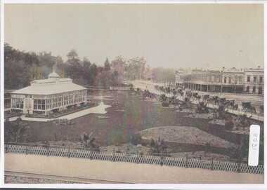 Bendigo Historical Society Inc.
Photograph - Bendigo Conservatory and gardens
Fifty nine acres of land was reserved for a park in1861, and the first gardener began setting out the gardens in 1870. The conservatory was built in 1897 and is the last building of its type in a public park.The conservatory was designed by Mr G. Minto, city surveyor at the time. The building is 72 feet long and 24 feet wide. The walls re twenty two feet high and are topped by a lantern roof, adding a further six feet. It was built at a cost of between 700 and 800 pounds.B&W photograph with view over the Bendigo Conservatory and gardens with a line of twelve horse drawn cabs on Bridge Streetconservatory gardens, bendigo -
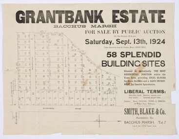 Bacchus Marsh & District Historical Society
Map - Land Sales Plan, Grantbank Estate Bacchus Marsh, 1924
The Grantbank Estate was a parcel of land close to the centre of the shopping area of Bacchus Marsh which was sub-divided and offered for sale in 58 lots on the 13th September, 1924. It comprised an area of 15 acres, being a portion of the Millbank Estate which had been in the hands of the Grant family for 75 years. The lots had frontages to Gisborne Road, Patterson, William and Sutherland Streets. This was a significant sub-division of land and represented a major expansion of residential housing in Bacchus Marsh in the early 20th century.This land sale map is a typical example of housing estate land sales advertising maps produced by real estate agents in this era. The map is significant for the detailed information it provides about when and where land was sold for new housing estates in Bacchus Marsh in the early twentieth century.Printed paper mapland sales bacchus marsh, land subdivsion bacchus marsh, housing estates land sales bacchus marsh, grant family bacchus marsh