Showing 952 items
matching bluestone%20buildings
-
 Flagstaff Hill Maritime Museum and Village
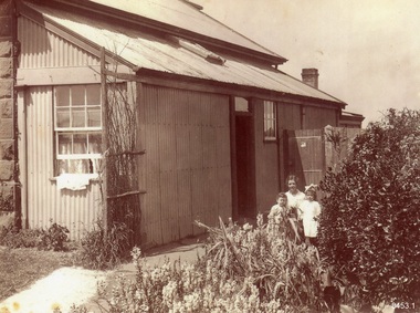
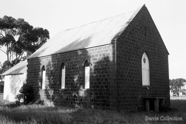
Photograph - Historical, building, Lighthouse Keeper's Quarters Warrnambool, Ca. 1917
This photograph of the Warrnambool Lighthouse Keeper's Quarters was donated together with an accompanying letter written by John Lindsay on October 21st, 1997. The letter was addressed to Howard Nicholl, the Director of Flagstaff Hill at that time. The following information was gleaned from the contents of the letter and the labels attached to the photograph:- The photograph of the Cottage was taken in about 1917. The woman is Gertrude Shade, married to James Shade, who was the Warrnambool Town Council's Officer responsible for keeping records of Shipping activity entering and leaving the busy Port of Warrnambool. The couple and their children, Janet and William, were residents of the Assistant Lighthouse Keeper's Quarters at that time. The family is pictured in the garden on the west side of the building. A washhouse, these days referred to as a laundry, is behind the building and had already been removed when the Flagstaff Hill Planning Board had access to the site in 1972. The corrugated iron veranda was replaced in the 1980s with a smaller covered entry. Janet Shade married the man who lived across the road, Stewart Lindsay, in 1935. Stewart was employed by Nestle at the age of sixteen, working in the export department. He was acting Manager when the Manager became ill, supervising the loading of dairy products and biscuits into the holds of the waiting ships, where they were then exported to Indonesia. Many of the ships were registered in Liberia and the seamen were called 'lascar seamen, or Indian Sailors. Janet and Stewart had a son, John Stewart Lindsay, who was a Pharmacist, a member of the Warrnambool City Council, the Mayor of the City of Warrnambool, a former Director of Flagstaff Hill, and Chairman of the Flagstaff Hill Advisory Committee.This photograph has significance as a historical record of the Warrnambool Lighthouse Kerr'er's Quarters in 1917. The photograph connects the cottage to local families, to local industry, to the Port of Warrnambool, and to overseas exports from Warrnambool. Photograph from c. 1917 depicts the western side of the Warrnambool's Lighthouse keeper's Quarters constructed in bluestone, which was where the Assistant Lighthouse Keeper resided. The image shows the corrugated iron lean-to, and other rooms that were added to the original building after 1872, which were removed in the 1970s due to their poor condition. The members of the family pictured were residents at the time; Gertrude Shade (Mrs James Shade), her daughter Janet and her son William. Inscriptions are on the reverse and the accompanying envelope. Typed label "Gertrude Shade with William and Janet. Lighthouse Keeper's Cottage, Flagstaff Hill, Merri St Warrnambool" Stamp "John Stewart Lindsay, Pharmacist, --0 Thompson Street Warrnambool 3280" "HOWARD NICHOLL / FLAGSTAFF HILL / MERRI STREET" " KEEP OUT OF REACH OF CHILDREN / Lindsay's Pharmacy / 119 Liebig Street, Warrnambool / Tel. 5561 4310" [round symbol of mortar and pestle] Typed letter (from John Lindsay to Howard Nicholl, October 21 1997)flagstaff hill, warrnambool, maritime museum, shipwreck coast, great ocean road, lighthouse keeper's quarters, lighthouse keeper's cottage, gertrude shade, james shade, janet shade, john stewart lindsay, stewart lindsay, nestle, warrnambool exports, port of warrnambool, planning board, 1917, howard nicholl, william shade, export to indonesia, janet lindsay -
 Bendigo Historical Society Inc.
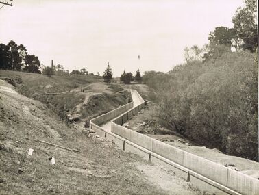
Photograph - JOSEPH BRADY COLLECTION: FLUMING BETWEEN MALMSBURY RESERVOIR AND CALDER HIGHWAY, 1934
Black and white photograph: image shows concrete channel snaking down hill, top LH side appears to be bluestone mill with tall chimney. Trees on RH side of channel. Comments on the back of the photo 'Between Malmsbury Res and Calder Hwy. 8 feet wide 4 foot 6 inches deep. Taken 1934. JA 10/81 concrete grand fluming at 12.5 miles Main channel 8 feet wide 4 foot 6 inches high. Constructed 1928.'place, water, coliban race, john brady collection. coliban race -
 Melton City Libraries
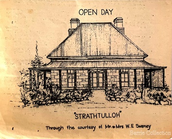
Drawing, Open Day at Strathtulloh, Unknown
"Strathtulloh, 1402-1600 Greigs Road, Melton South, is significant as an early property in Victoria, retaining different eras of pioneering dwellings, ranging from a ruin to a fine Colonial style homestead. The property has close historical association with the early settlement of the Melton district, and was owned by the Henty family in the 1840s. The Strathtulloh property was alienated by the Crown in 1840 to Charles James Garrard, who sold it in 1848 to Charles and Stephen Henty, whose sister Jane and her husband Samuel Bryan lived there in the late 1840s. In 1853 the property then passed to William Tulloh, after whom the homestead was named. A primitive bluestone ruin of near the Toolern Creek, built of vesicular bluestone and mud mortar, is of unknown origin. It has commonly been assumed to pre-date 1840, and to have belonged to the original holder of the Exford lease, Dr Watton or Port Phillip Association member Dr Cotterill. This is unlikely, as the 1841 census records Dr Watton, and everyone else in the district, as living in a ‘wood’ dwelling. It may instead have been the residence of Garrard, and the Bryans, in the 1840s and an early map names a site near here as ‘Bryan’s outstation’. It is assumed that the two-level stone building that became the kitchen is the earliest intact building on the site, and was the first homestead; it is likely to date to the 1840s or 1850s. The main homestead is a substantial villa constructed of random coursed bluestone, with a verandah facing three sides, attic bedrooms with dormer windows, a fan light over the front door, a hipped roof originally clad in slate, and a large cellar. Although demonstrating characteristics of pioneering construction, such as unworked log beams, pit sawn beams, hand-sawn lintels and colonial door locks, documentary evidence shows that it was built c.1869. The homestead has now been structurally repaired and decoratively restored; a sympathetic new semi-detached rear extension was added in the early years of the 21st century. The former kitchen building has also undergone minor repairs and alterations". Strathtulloh Homestead at 1402-1600 Greigs Road, Melton Southlocal architecture -
 City of Moorabbin Historical Society (Operating the Box Cottage Museum)
Booklet - St John's Church of England, East Bentleigh, The New Church, 1963
St John's Church of England first Church was built by the parish of Bentleigh in 1873. The present site, on the south- east corner of Centre and Tucker Roads, was donated by parishioner named John, in whose honour the new church was named St John’s. Erection of a modest brick and bluestone building began in October 1872, and the first service was held on Sunday, 11 May 1873. In the August 1961 a foundation stone was laid to begin the building of the new Church to meet the demands of the present congregation. It was designed by Gawler, Churcher & Boardman (David Gawler) and the builder was Colin D Mason. St John's Church of England Bentleigh was erected in 1873 and was integral to the spiritual well being and social life of the early settlers.Booklet describing the new church and the history of St John's Church of England, Centre Road, East Benteligh, with photosreligin, church of england, anglican, bentleigh, st john's, centre road, tucker road -
 Kew Historical Society Inc
Photograph, Outer Circle Railway Bridge over River Yarra, c.1900
This photograph forms part of the Eric Sibly collection of images and information relating to the Outer Circle Railway which he donated to the Kew Historical Society in 1974. Heritage Victoria Citation (Abridged) "The Chandler Highway Bridge, a 137 metre wrought iron lattice-truss girder bridge with four spans supported on red brick piers with moulded bluestone cappings. The bridge has a cantilevered walkway along the west side. ...The Chandler Highway Bridge crosses the Yarra River and connects Alphington and Kew. It was completed in November 1890 as part of the Outer Circle Railway Line.Black & white photograph of the railway viaduct over Yarra River looking south towards Kew.Reverse: "Pre 1930. Outer Circle Railway Bridge over River Yarra (now Chandler Highway) - note bridge over line on Kew side for Asylum Farm". KH - 56. Kew Historical Society.chandler highway, railway bridges - kew (vic), sir john monash, outer circle railway, river yarra - kew (vic) -
 Melton City Libraries
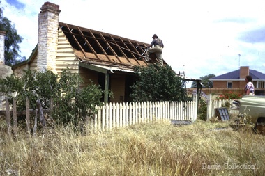
Photograph, Ned Toohey's house, McKenzie Street, 1970
Cottage of Edward Toohey (died 1898) a Shire contractor and road maker. Ned, his son worked with Frederick Myers building many of the bluestone roads in the Shire of Melton. In the background is the brick house built for Martha Myers in 1967. Martha and husband Frederick (born 1877 in Melton) resided in the Myers (Miers) house on Western Highway beside the gully near Reserve road. Frederick lived there for 86 years. The house was built in 1867 by Henri and Ann nee Dowling Myers. Demolished 1968. Martha Myers house was demolished in 2011 to become a car park. Mary and Jack Tolhurst removing roof of Ned Tooheys house (site of Senior Citizens ).local identities, misc. -
 Melton City Libraries
Photograph, Wesleyan Church, Unknown
On the 16th April the foundation stone of the Wesleyan Church was laid and does not appear to have been marked. It was opened for public worship on Oct 13th 1867. Rev Ken Moore of Melbourne was the preacher, only 6 months after the commencement of building. It was constructed of bluestone with a slate roof. The interior had not been plastered, nor ceiling erected, but would be a funds permitted. Cost at opening was L350/13/6; seats and deskL40. A Tea meeting was held to celebrate the opening on the following night. Church closed in 1910. Has been used as a den for the Djerriwarrh Scout Troop.Formerly Melton Wesleyan Church on Palmerston Streetchurches, local architecture -
 Port Fairy Historical Society Museum and Archives
Postcard - Pencil Drawing
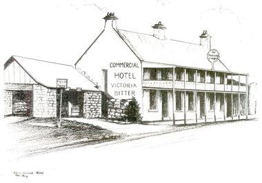
John J. Huntly appears to have been the only licensee of the Royal Oak Hotel, built in 1858. He was a Councillor of the Municipality of Belfast at the time and later became the Secretary of the newly formed Minhamite Shire in 1872. By 1861 D. Smith appears as the licensee of the now named Commercial Hotel. In 1877 it was offered for sale—the building described as follows “Built of bluestone with slate roof, having a frontage to Bank street of 106 feet, 6 inches. Accommodation consists of twelve bedrooms, eight sitting rooms, bathroom, bar and cellar and detached kitchen also of bluestones, with outside offices. Around this time beside its usual business the hotel had various rooms for visiting doctors and a dentist. Dr. Berncastle, who was associated with the Sydney Eye Infirmary, performed several operations there on those suffering from cataracts. It was the meeting place for the Port Fairy Freemasons, before their Lodge was built in James street, and all the local sporting clubs, at one time or another. The veranda was added in 1900. The name Royal Oak was restored this century, but the name Commercial Hotel can still be seen in the leadlight window over the front entrance. The hotel still continues serving patrons with beverages and meals but no beds these days. There is also an addition to the building, as seen in the bottom illustration— a bottle shopBlack and white sketch photographed Line drawing of the Commercial hotelhotel, building, commercial, oak and anchor, inn, pub, d.smith -
 Port Fairy Historical Society Museum and Archives
Photograph
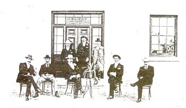
John J. Huntly appears to have been the only licensee of the Royal Oak Hotel, built in 1858. He was a Councillor of the Municipality of Belfast at the time and later became the Secretary of the newly formed Minhamite Shire in 1872. By 1861 D. Smith appears as the licensee of the now named Commercial Hotel. In 1877 it was offered for sale—the building described as follows “Built of bluestone with slate roof, having a frontage to Bank street of 106 feet, 6 inches. Accommodation consists of twelve bedrooms, eight sitting rooms, bathroom, bar and cellar and detached kitchen also of bluestones, with outside offices. Around this time beside its usual business the hotel had various rooms for visiting doctors and a dentist. Dr. Berncastle, who was associated with the Sydney Eye Infirmary, performed several operations there on those suffering from cataracts. It was the meeting place for the Port Fairy Freemasons, before their Lodge was built in James street, and all the local sporting clubs, at one time or another. The veranda was added in 1900. The name Royal Oak was restored this century, but the name Commercial Hotel can still be seen in the leadlight window over the front entrance. The hotel still continues serving patrons with beverages and meals but no beds these days. There is also an addition to the building, as seen in the bottom illustration— a bottle shopBlack and white photograph of 8 males formally posed outside entrance to Commercial hotelhotel, building, kemp family, bank street, royal oak, commercial, oak and anchor, d.smith -
 Flagstaff Hill Maritime Museum and Village
Furniture - Cupboard, c. 1890
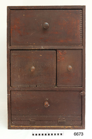
The materials used to build the colonial cupboard have been gathered from various sources and recycled. In those days, it was normal to keep all manner of items 'just in case' they could be repurposed for another item. The brand "Laurel" on one of the wooden panels is from the Mobil Oil company's kerosene. There In the words of the donor, Betty Stone, "Made by Ellis Dale of Latrigg Wangoom, Warrnambool c 1890. The cupboard consists of packing cases stamped with original brand names. One drawer made from a gelignite packing case is of special significance as the Dale family owned a bluestone quarry known as The Dale Bluestone Quarries at Wangoom situated about three miles east of Warrnambool. Ellis Dale, second son of William Dale and Elizabeth (nee Chamberlain) Dale, was born in Wangoom, Warrnambool on 21 November 1860. His father, William Dale, a quarryman from Saddleworth, Yorkshire migrated to Australia in 1852; seven years later - in 1859- he purchased the quarries on twenty acres of land situated in Wangoom at the corner of what is now known as Dales and Aberline Roads. Later, when his two eldest sons, William Jnr and Ellis, reached ten or eleven years of age they worked with their father in the quarries. The work was arduous and dangerous as gelignite was used to blast the bluestone. In 1890 Ellis Dale married Ann Lees, daughter of Lees and Sarah (nee Chamberlain) Lees of Wangoom, Warrnambool. Initially Ellis and Ann Dale resided in a two roomed bluestone cottage which Ellis built a little further up the hill from his parents' home on the Dale family property. A few years later, in order to accommodate their growing family, additional rooms were added making a spacious, comfortable weatherboard home situated in Dales Road which they named Latrigg. Ellis Dale constructed this cupboard soon after he and Ann first set up home in their little stone cottage in 1890. When the home was rebuilt, the home-made cupboard was moved into the larger kitchen, and although Latrigg was well furnished, it remained in the corner between the kitchen door and the large wood stove where it served its purpose very well as it was used for storing ironing utensils. The lower compartment with the hinged drop-door was designed to store the flat irons which were heated on the wood stove, while the ironing blanket and cover, iron holders and other items were stored in the drawers. The Dale quarrying and contracting business existed in Wangoom, Warrnambool for over eighty years as after William Dale’s death. Ellis Dale together with his son lvor, continued on until he died in 1940. (Note: For additional information please refer to Betty Stone’s book “Pioneers and Places - A History of three Warrnambool Pioneering Families” i.e. Chamberlain, Dale and Lees Families)This item is associated with families of Chamberlain, Dale and Lees. These families are listed in the "Pioneers' Register" for Warrnambool Township and Shire, 1835-1900, published by A.I.G.S. Warrnambool Branch.Cupboard, rare example of a Colonial Cupboard, wooden. Made by Ellis Dale from packing cases; several brand names are evident inc. Gelignite and Laurel. Cupboard is lined with newspaper and wallpaper. Panels on left side are braced by attaching a metal scraper. Comprises four compartments, three have round wooden handles, lower compartment has a hinged, drop down door. (From the Chamberlain, Dale and Lees Collection)Brands on wooden panels of cupboard include "Gelignite" and "Laurel" (Laurel is a brand of kerosene)flagstaff hill, warrnambool, shipwrecked coast, flagstaff hill maritime museum, maritime museum, shipwreck coast, flagstaff hill maritime village, great ocean road, chamberlain, dale, lees, stone, betty stone, warrnambool pioneers, dale bluestone quarries, wangoom, cupboard, colonial cupboard, furniture, gelignite, packing crate, ellis dale, laurel -
 Kew Historical Society Inc
Photograph, Façade of ‘Southesk', Cotham Road, 1970
Colour enlargement of a photograph (slide) of Southesk (formerly Ordsall) in Cotham Road, Kew (demolished 1970).Colour photograph of the front lawn and façade of ‘Southesk’ (formerly ‘Ordsall’, built for John Halfey in 1882). The house was located on the corner of Cotham Road and Charles Street, Kew. The Italianate mansion was built in the Renaissance villa style on a bluestone plinth. Two balustrades surrounded the parapet of the roof and ran between the groups of pillars on either side of the entrance porch. The verandah was tiled and wide and Corinthian columns supported its roof. When the house passed into the hands of the City of Kew in 1948, the landscaping and formal flower beds were removed and replaced by lawns.The house was demolished in 1970.david carnegie, john halfey, southesk - cotham road - kew (vic), ordsall - cotham road - kew (vic) -
 Eltham District Historical Society Inc
Photograph, Not Just a Pretty Place, Aleks Danko (2000), Lennister Farm, Eltham South, 2000c
The sculpture was launched on 9th August 2000 by Cr Diane Bullen and welcomed by Annette Xiberras of the Wurundjeri community. Not Just a Pretty Place acknowledges the cultural significance of this site for the residents of Nillumbik Shire and for the Wurrundjeri community. Historically the confluence of rivers have particular importance as these were sites where rituals and ceremonies took place. The carved bluestone form presents an oversize river pebble that echoes the spirit of the water and draws attention to this location as a meeting place an landmark. Awarded the 2000 Nillumbik Art in Public Places Award and situated behind Lennister Farm near Yarra ParkColour photograph printaleks danko, eltham, lennister farm, yarra park, cr. diane bullen -
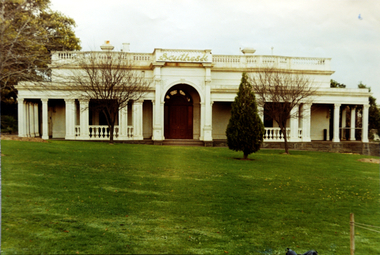
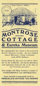 Federation University Historical Collection
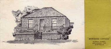
Card - Card - Advertising, ZILLES COLLECTION: Advertising Card for Historic Montrose Cottage and Eureka Museum
Zilles Printers was begun by Lewis Zilles in the early 1930s. It was in McKenzie Street Ballarat. His son Jeffrey also became a printer - letterpress, offset and screen printer. The business became Zilles Printers/Graphics and was in Armstrong Street and later Bell Street Ballarat. Montrose Cottage was build c1856 by John Alexander, builder. He was a Scottish stone mason. It was built with bluestone and hand-made bricks. It is on the Historic Buildings Register, National Trust (Victoria). It is important as a substantial and very early stone cottage. The house is now open to the public. It also provides short term accommodation - self contained apartments.Yellow card with dark blue printDrawing of cottage and on reverse side map.zilles printers, montrose cottage, john alexander, scottish stone mason, bluestone, hand-made bricks, historic buildings register, short term accommodation, national trust, apartments -
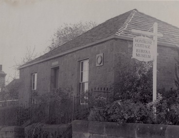 Federation University Historical Collection
Photograph - Photograph - black and white, ZILLES: Photographs of Montrose Cottage and Eureka Museum
Zilles Printers was begun by Lewis Zilles in the early 1930s. It was in McKenzie Street Ballarat. His son Jeffrey also became a printer - letterpress, offset and screen printer. The business became Zilles Printers/Graphics and was in Armstrong Street and later Bell Street Ballarat. Montrose Cottage was build c1856 by John Alexander, builder. He was a Scottish stone mason. It was built with bluestone and hand-made bricks. It is on the Historic Buildings Register, National Trust (Victoria). It is important as a substantial and very early stone cottage. The house is now open to the public. It also provides short term accommodation - self contained apartments.Three black and white photographszilles printers, montrose cottage, eureka museum, ballarat -
 Greensborough Historical Society
Photograph - Digital Image, Pioneer Reserve 2014 -1, 21/05/2014
Pioneer Reserve, Greensborough is a small park on the corner of St Helena and Diamond Creek Roads. It is adjacent to the site of Greensborough's first bridge across the Plenty River, c. 1864 - 1960s. The shelter, viewing platform, retaining wall and entrance are built from the bridge's massive bluestone arched abutments dismantled between 1974 and 1983. Pioneer Reserve is historically significant for its formative association with noted local landscape designer Gordon Ford in 1968, and it is likely that remnant large field stones at the entrance drive to the Reserve remain from his design. Photograph by Marilyn Smith 2014.Digital copy of colour photograph. -
 Whittlesea Historical Society Inc.
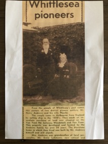
Newspaper - Newspaper clipping, Copy, Whittlesea pioneers, unknown
Transcript: Whittlesea Pioneers From the annals of Whittlesea's past comes this picture of two distinct pioneer settlers, Mr Henry Andrews and his wife Phoebe. The couple came to Melbourne from England by sailing ship in the 1850's. They made an immediate purchase of land now situated on the Yan Yean Rd between Woodstock and Yan Yean. This property was developed and farmed by the Andrews family for over 50 years. The bluestone home in which they lived was built by Mr. Andrews himself and still stands. Mrs. Andrews was grandmother of local personality, Mr. Ernie Lehmann, now retired andNewsprint, copy, very poor quality, blurry image and text, not dated, source unknown.whittlesea, henry andrews, phoebe andrews, andrews family whittlesea, yan yean, ernie lehmann -
 Warrnambool and District Historical Society Inc.
Tools, Miner's Pick, Early 20th century
This miner’s pick was of the type used to extract limestone at the Warrnambool limestone quarries, mainly for buildings and walls. This pick cut the sides and the top of the block and then it was levered off with a crowbar at an angle of about 30° to 40°. These blocks were then reduced to the required size using cross cut saws. There were about 12 limestone quarries operating in Warrnambool in the 19th century and limestone was extensively quarried for about 85 years to the 1930s when quarrying ceased. Today there has been a small revival in the Warrnambool area in the use of limestone blocks for building. Warrnambool also once had several bluestone quarries on the outskirts of the town. This miner’s pick has a wooden handle with rounded sides tapering to a wider end. The wood is weather-worn and split in places, especially at the top end. The pick is metal with a curved shape that tapers to a point at one end. The metal near the other end has a cavity into which is inserted the wider end of the wooden handle. limestone quarries in warrnambool, quarrying in warrnambool, warrnambool history -
 Warrnambool and District Historical Society Inc.
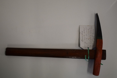
Tool, Miner's Pick
This miner’s pick was of the type used to extract limestone at the Warrnambool limestone quarries, mainly for buildings and walls. This pick cut the sides and across the top of the block and then the block was levered off the strata using a crowbar at an angle of 30° or 40°. These blocks were then reduced to the required size using cross-cut saws. There were about 12 limestone quarries operating in Warrnambool in the 19th century and limestone was extensively quarried for about 85 years to the 1930s when the quarrying ceased. Today there has been a small revival in the use of limestone blocks for building. Warrnambool also once had several bluestone quarries on the outskirts of the town. This miner’s pick is of considerable interest as an example of the type used in quarrying limestone in Warrnambool . Quarrying was once an important industry in Warrnambool. This miner’s pick has a short wooden handle with a metal stud inserted at the bottom end. The handle is rounded on the sides and tapers slightly from the top to the bottom. The metal pick has a curved shape with one blunt end and one sharp end. It has a cavity in the end nearest the blunt end and the wooden handle slots into this. The pick is painted black, green and orange, perhaps for display purposes. A handwritten information tag is attached to the handle. quarrying in warrnambool, limestone quarries in warrnambool -
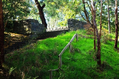
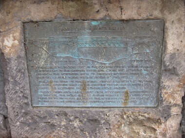 Greensborough Historical Society
Photograph - Digital image, Bridge Plaque - Pioneer Park Greensborough, 27/03/2010
Plaque at Pioneer Reserve Greensborough: "Shire of Diamond Valley. The bluestones used in the construction of this viewing platform and in the carpark entry structure and retaining wall are from the northern arch of Greensborough's first Plenty River Bridge built in the 1860s adjacent to this site. The centre span of the original bridge was removed in 1865 when the western half of the existing bridge was constructed leaving the northern and southern stone arches. The southern arch was retained until floods in 1874 necessitated its removal. The picnic shelter in this reserve was constructed using stone from this abutment. The northern arch was removed in 1983 when widening of the existing bridge commenced."Digital copy of colour photograph.plenty river, pioneer reserve greensborough -
 Kew Historical Society Inc
Photograph, Façade of ‘Southesk', Cotham Road, 1970
Colour enlargement of a photograph (slide) of Southesk (formerly Ordsall) in Cotham Road, Kew (demolished 1970).A colour photograph of the façade of ‘Southesk’ taken at an oblique angle. Formerly known as ‘Ordsall’, the house was built for John Halfey in 1882 on the corner of Cotham Road and Charles Street. The Italianate mansion was built in the Renaissance villa style on a bluestone plinth. Two balustrades surrounded the parapet of the roof and ran between the groups of pillars on either side of the entrance porch. The verandah was tiled and wide and Corinthian columns supported its roof. When the house passed into the hands of the City of Kew in 1948, the Council used it for a kindergarten, an elderly citizen centre and as a home for the Leo Baeck Centre. The house was demolished in 1970.david carnegie, john halfey, southesk - cotham road - kew (vic), ordsall - cotham road - kew (vic) -
 Kew Historical Society Inc
Photograph - Façade of ‘Southesk', Cotham Road, Stewart West, 1970
Colour enlargement of a photograph (slide) of Southesk (formerly Ordsall) in Cotham Road, Kew (demolished 1970).A colour photograph of the façade of ‘Southesk’ taken at an oblique angle. Formerly known as ‘Ordsall’, the house was built for John Halfey in 1882 on the corner of Cotham Road and Charles Street. The Italianate mansion was built in the Renaissance villa style on a bluestone plinth. Two balustrades surrounded the parapet of the roof and ran between the groups of pillars on either side of the entrance porch. The verandah was tiled and wide and Corinthian columns supported its roof. When the house passed into the hands of the City of Kew in 1948, the Council used it for a kindergarten, an elderly citizen centre and as a home for the Leo Baeck Centre. The house was demolished in 1970.david carnegie, john halfey, southesk - cotham road - kew (vic), ordsall - cotham road - kew (vic) -
 Kew Historical Society Inc
Photograph - Denmark Street, Kew, 1972
The Engineer's Department of the former City of Kew had an extensive collection of photograph of sites in Kew requiring documentation to inform public works. It also kept images of engineering practice in other parts of Melbourne, and overseas, that could be used as models for local activity. Many of these photographs (and plans) were donated to our collection in the 1980s. A number of the photographs are annotated, either on the image itself or on the reverse.This photograph, and others sourced from the City Engineer's Department of the former City of Kew, qualifies as an important record of local streets, public works, street beautification, and engineering techniques of the period. Original black and white photographic positive of automobiles and buildings in Denmark Street, Kew, immediately before the road enters Kew Junction. On the left is McKeon Motors and a retailer of Insulwool, while in the distance is the pharmacy on the corner of High Street and Princess Street (later demolished during the widening of Kew Junction). Notable are the bluestone guttering and what appears to be vacant land on the apex of the triangle of land bounded by High Street South, Denmark Street and Barkers Road. This site was the original location of O'Shaughnessy's 'Kew Hotel', and after the destruction by fire of the latter, the location of a service station. [It is now the site of the Cresco Reserve].Annotation verso: "Indicating the existence of a vehicular entrance at Denmark St abuttal of No.188 High St prior to reconstruction of channeling &c 1972."denmark street -- kew (vic.), kew junction, luestone gutters, mckeon motors, insulwool -
 Ringwood and District Historical Society
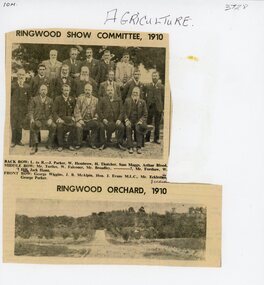
Document, Packet: Agriculture (Ringwood): Cuttings, Handwritten ""Sowing Wheat" Notes (Greg Dawson), 1909-1986
Agriculture; Poultry; Wheats; Dams; Mud Bricks; Ringwood Show Committee 1910 +Additional Keywords: Dawson, GregPacket includes: . Newspaper cutting showing Ringwood Show Committee, 1910, and Ringwood Orchard, 1910. . Letter from the Ringwood Fruit Association Limited dated 3 September, 1921 re supply of bluestone. . Hand written note on report of Ringwood Show 1909. . Extract from "The Victorian Poultry Journal" 1931 about the formation of a branch at Ringwood. . Extract from notes written by Mr. Greg Dawson of Merrigum aged 94, 1967, re sowing wheat, dams, mud bricks, and school. -
 Warrnambool and District Historical Society Inc.
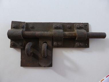
Artefact, Old gaol lock, c.1880
This lock was once used in the old 19th century gaol in Gilles Street, Warrnambool. The gaol is part of a group of four heritage buildings which comprise a police station, a police residence, police stables as well as the gaol. These were built between 1883 and 1888 from the designs of the Victorian Public Works Department architect, E.R. Laver. He was responsible for the designs of many 19th century country police stations, post offices and courthouses in Victoria. The four heritage buildings, of which the gaol is one, are important because they are some of the few surviving Warrnambool 19th century bluestone buildings. Today they form part of the South West Tafe Complex. This lock is of considerable interest as one used in the Warrnambool 19th century gaol building. The door on which it was used appears to be walled up now. This is a large iron lock with a base plate with three rivets and a projection piece. There are three curved iron pieces on the plate and these are fixed to the plate with 12 rivets. The bolt is rounded and moves under the three curved pieces across the plate. There are two other curved pieces, part of the bolt locking system. The lock has surface rust. warrnambool police and gaol heritage buildings, history of warrnambool -
 Federation University Historical Collection
Card - Card - Greetings, ZILLES COLLECTION: Montrose Cottage Christmas Card
Zilles Printers was begun by Lewis Zilles in the early 1930s. It was in McKenzie Street Ballarat. His son Jeffrey also became a printer - letterpress, offset and screen printer. The business became Zilles Printers/Graphics and was in Armstrong Street and later Bell Street Ballarat. Montrose Cottage was build c1856 by John Alexander, builder. He was a Scottish stone mason. It was built with bluestone and hand-made bricks. It is on the Historic Buildings Register, National Trust (Victoria). It is important as a substantial and very early stone cottage. The house is now open to the public. It also provides short term accommodation - self contained apartments. Card produced for Christmas. It has a brief history of the Cottage inside.Thick textured paper, folded. Mustard section with black print. Black and white drawing of cottage."Best Wishes for Christmas and the New Year"zilles printers, ballarat, christmas card, montrose cottage -
 Eltham District Historical Society Inc
Photograph, Near 145 Mountainview Road, Briar Hill, early to mid 1960s, 1960s
In this picture we see the cement mixer on the right so possibly stone work being undertaken both sides of the street. Work is under way at the house one down from the bend where two piles of bluestone are gathered; possibly for terrace edging of the driveway and footpath. These images were from a strip of negatives, most likely taken by a Shire of Eltham employee so the works could have been part of council operations. Many streets in the shire have stonework edges for gardens abutting footpaths where the roads have been cut into the terrain. Much of this stone masonry work was undertaken for the council by C.J. Watson and Sons.Roll of medium format 120 6x6 black and white negative film, 1 stripbriar hill, c.j. watson and sons, fx holden, mountainview road, side-car, motorcycles -
 Victorian Interpretive Projects Inc.
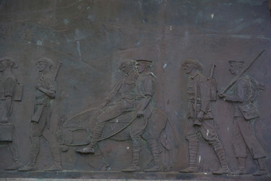
Photograph - Colour, Ararat War Memorial, 13/08.2012
"ARARAT WAR MEMORIAL.- Remarkable simplicity and beauty are combined in the Ararat war memorial, which will be unveiled by Senator H.E. Elliott to-morrow. The monument is a simple rectangular stone mass, 12ft in length, 6ft in width, and 18ft m height, standing on a bluestone platform of three steps in the centre of a formal garden Surrounding the memorial is a bronze frieze, conceived from the classic frieze of the Parthenon in Athens depicting incidents in Australian engagements overseas. The frieze took the sculptor (Mr Wallace Anderson) two years to complete. The memorial was designed and supervised by Mr A.S. Hall. Photographs of the memorial are included in the collection at the architectural exhibition it the Town Hall." (The Argus, Friday 8 August 1930) A number of colour photographs showing details from the Ararat War Memorial.ararat, ararat war memorial, ararat cenotaph, wallace anderson, a.s. hall, world war, nurse -
 Nillumbik Shire Council
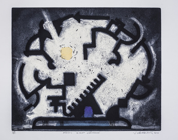
Print (etching, acquatint, stencil): Jock CLUTTERBUCK (b.1945), Jock Clutterbuck, ‘Frosty Night Cartouche’ from 'The Baldessin & Friends' commemorative folio, 2016
Jock Clutterbuck is a sculptor and printmaker of national significance, known for his sophisticated abstract forms with underlying esoteric mysticism. Clutterbuck overlapped with Baldessin when he studied sculpture and printmaking at the Royal Melbourne Institute of Technology, RMIT (1965-66). He taught at RMIT from (1969-73) before lecturing in sculpture at the Victorian College of the Arts (1974-2000). He is represented in many national and international public art collections and is a recipient of many National prizes and awards. George Baldessin (1939-1978) was a printmaker and sculptor who built his bluestone studio at St Andrews (Nillumbik) in 1971. The bluestone studio was hand built by George, his partner Tess and the three Hails brothers, Rob, Doug and Don. Made of recycled materials the studio today contains all of George’s equipment including the large press, which he modelled himself with the help of Neil Jeffrey (Enjay Presses). George won many prizes throughout his career and is represented in many of Australia's public art collections including his famous 'Pears' sculpture in front of the National Gallery of Australia, Canberra. In 1975 he represented Australia in the Sao Paulo Biennale, before living and working in Paris until his return to St Andrews in 1977. In 1978 George was killed in a car accident aged 39 years. In 2001 Tess returned to St Andrews to reclaim the run-down studio and reconstitute it as The Baldessin Press & Studio - a printmaking retreat. It operates in George’s memory, so that artists may continue to create, perpetuating the generous spirit of George.‘Frosty Night Cartouche’ is one of eight prints in the 'Baldessin & Friends commemorative folio. The folio was conceived by Tess Edwards as a fundraising initiative in celebration of the The Baldessin Press & Studio's fifteen year anniversary, and as a way to honour George Baldessin's memory. The Baldessin Press & Studio is a not-for-profit organisation created in memory of the late George Baldessin (1939-1978), whose original studio is now open to the public for creative use and as a practical legacy to living artists. The Studio is located in St Andrews, Nillumbik. The folio is a unique coming together of seven very different and acclaimed artists who are connected by their friendship to the missing eighth member, George Baldessin. Following a visit to the Press in 2015, Clutterbuck was reminded of a suite of paintings he had produced some thirty years earlier inspired by plein-air drawings of the night sky. This print attempts to capture something of the enchantment, mystery and drama of a frosty rural property where Clutterbuck spent many years. It is a frost dreaming; a subtle personal homage to Baldessin, embodying the reverence of a fellow artist towards an old friend. In pencil (handwritten): low plate: left '14/25' (edition); centre 'Frosty Night Cartouche' (title); right 'Jock Clutterbuck' (signature); low paper: right emboss 'GB' (Baldessin Press & Studio monogram)ekphrasis2018, symbols -
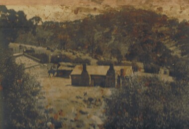 Bendigo Historical Society Inc.
Photograph - THE SPRINGS, SEDGWICK
Photograph - black and white. Photograph of 'The Springs, Sedgwick', 14 miles from Bendigo. Rocky, hilly landscape with scattered trees, two chimneys on the main building in the centre, horse and rider approaching the building. Also 3 current photographs taken by Phillip Wilkin on July,2009. The 3 current photo's showing bluestone ruins - it is the same building on the left of the old photo - not the building with 2 chimney's, the one hidden behind trees (you only see part of it). Phillip's grandfather (Charles Wirth) moved here in 1901, along with his parents and grew up in that building (now ruined), the family still own the land.place, land, the springs, sedgewick., the springs, sedgwick. -
 Surrey Hills Historical Society Collection
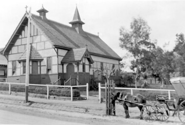
Photograph, Holy Trinity Church, Surrey Hills in the 1920s
This church was built in 1907 and became known as Holy Trinity Surrey Hills. This name had previously been used by the Anglican Church in Mont Albert Road, Mont Albert. This henceforth became known as St George's Anglican Church, Mont Albert. There are 2 copies: the original donated print and an enlargement. The original is mounted on card with photo mounts along with 890, 891 and 892. It measures 13 cm x 9 cm. Norman Carter took many photos of Surrey Hills and Mont Albert from the 1920s in particular of events and activities associated with the Church of England.Black and white photo of the original Holy Trinity Church building in Union Road. It is constructed of weatherboards, above which there is plasterboard and timber strapping. The roof is of terracotta tiles with a small steeple at the front and a larger one towards the rear of the building. There is a box bay window at the front and the entrance is from a porch on the southern side of the building. This is approached by stairs. Part of the vicarage can be seen on the northern high side of the church and to the south there is vacant land. The whole property sits behind a simple post and wire fence. There is a phaeton in the foreground beside a relatively newly planted street tree. The road has bluestone kerb and channelling.churches, holy trinity church, anglican church, horse-drawn vehicles, norman brodley carter, union road